It looks like you're using an Ad Blocker.
Please white-list or disable AboveTopSecret.com in your ad-blocking tool.
Thank you.
Some features of ATS will be disabled while you continue to use an ad-blocker.

ABC Producer Arrested in Denver For Taking Pictures of Senators, Big Donors!
page: 1share:
ABC Producer Arrested in Denver For Taking Pictures of Senators, Big Donors!
abcnews.go.com
(visit the link for the full news article)
DENVER--Police in Denver arrested an ABC News producer today as he and a camera crew were attempting to take pictures on a public sidewalk of Democratic Senators and VIP donors leaving a private meeting at the Brown Palace Hotel. Police on the scene refused to tell ABC lawyers the charges against the producer, Asa Eslocker, who works with the ABC News investigative unit.
A cigar-smoking Denver police sergeant, accompanied by a team of five other officers, first put his hands on Eslocker's neck, then twisted the producers arm behind him to put on handcuffs.
[edit on 27-8-2008 by DimensionalDetective]
What the?!?
HOW MUCH FURTHER OUT OF CONTROL IS THIS POLICE STATE NONSENSE GOING TO GET?!?
So now a SIDEWALK bordering the street is PRIVATE PROPERTY?
This has gotten so out of control anymore that it is jaw-dropping IMO...
I found the below paragraph the most interesting in relevance to this:
abcnews.go.com
(visit the link for the full news article)
HOW MUCH FURTHER OUT OF CONTROL IS THIS POLICE STATE NONSENSE GOING TO GET?!?
So now a SIDEWALK bordering the street is PRIVATE PROPERTY?
This has gotten so out of control anymore that it is jaw-dropping IMO...
I found the below paragraph the most interesting in relevance to this:
Eslocker and his ABC News colleagues are spending the week investigating the role of corporate lobbyists and wealthy donors at the convention for a series of Money Trail reports on ABC World News with Charles Gibson.
abcnews.go.com
(visit the link for the full news article)
Land of the free?
Yeah right.
Enjoy your gilded cages, slaves.
The good news is that this isn't some Joe Schmuck with a camera... you're going to hear about this one (I hope).
.
Yeah right.
Enjoy your gilded cages, slaves.
The good news is that this isn't some Joe Schmuck with a camera... you're going to hear about this one (I hope).
.
And that my friends is why I heartily encourage all True Americans to be sure that they own a Non-registered firearm and have the willingness to use
it. The Police are your neighbors one day and your tormentors the next. Be sure to place your unregistered weapons in a good hiding place and be sure
you have ammunition.
And some blind and ignorant peeps out there still defend these extremely high paid gun toting security guard order following morons.
And some blind and ignorant peeps out there still defend these extremely high paid gun toting security guard order following morons.
The sheriff's officer is seen telling Eslocker the sidewalk is owned by the hotel. Later he is seen pushing Eslocker off the sidewalk into oncoming traffic, forcing him to the other side of the street.
BULLS**T!
You learn a few things when you make your living as an engineer and one of those things is how to find parcel ownership information which is used in right of way acquisitions & boundary restrictions on roadway design.
I searched for the Brown Palace Hotel and found it was located at 321 17TH ST in Denver. I then did a quick Yahoo for +Denver +"Parcel Viewer" and found a link to Denver's city parcel resource page where I typed in the address. A quick search found the parcel and by chooseing the map options, I turned on the 2006 color aerial image overlay for the parcel which includes a very clear sidewalk & curb/gutter line for the streets surrounding the property. (The slight offset between the building & the parcel line is because of the 3/4 perspective used to shoot aerial flyovers combined with the elevation of the building's roof.)
Link
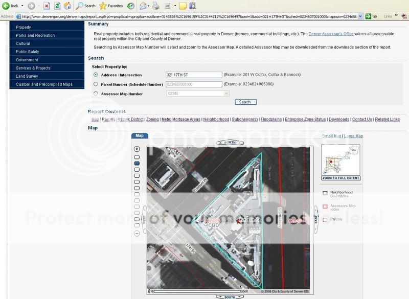
Unless this man was standing inside one of the three triangulation points (an old holdover from years ago when parcels technically ran to monument points located in the roadway on angles less than 30 degrees) he was clearly and blatently standing on publically owned, city, county, or state land paid for by taxpayers and I hope he sues their asses for violating the freedom of the press over this.
(EDITED TO ADD LINK TO DENVER PARCEL VIEWER WEBPAGE)
[edit on 27-8-2008 by burdman30ott6]
Mod edit: fixed large linking address using the proper tags
[edit on 8/27/2008 by Gools]
Don't worry folks... David Lane, famous Denver Attorney, will be owning these losers in the very near future. The city of Denver will go broke
paying their legal bills this coming year and Chickenpooper, the mayor, and Tax Ritter, the governor will be out of office soon, no re-elected nor
will they progress in the Democratic party...
reply to post by burdman30ott6
Excellent work!
In a day and time where media is so disgustingly controlled and spewing out propeganda like there's no tomorrow, for a few folks to actually go out on a limb and investigate this CRIMINAL CONGRESS of ours, then be bullied, harrassed and ARRESTED because of "rattling cages" of these crooks, is the ultimate travesty.
This is such a blatant violation of the "free" press (which for the most part is anything BUT free) that it is of the utmost importance that this be put out on every non-corporate owned site there is...
The Constitution has been vanishing before our eyes, and this is a glaring example of how this process is escalating and spiraling totally out of control!
The following is my opinion as a member participating in this discussion.
Ridiculous. Absolutely ridiculous.
This is a case of censorship and harrassment. They wanted this guy out of the way for the short term. There's no way in hell that this charge is going to hold up in court.
As an ATS Staff Member, I will not moderate in threads such as this where I have participated as a member.
This is common. This is normal. This happens everyday. That is the state of the nation you live in. The press is censored and controlled. People get
disappeared. You may of thought things like controlled media was restricted to Russia or China but it is just the same here as it is there. And that
is now the way of things. If you get out of line the police will take you out. They will not face charges. They being of law enforcement are ABOVE the
law.
Has that sunk in yet? They can beat you , mace you , and Taze you, and then you will be charged with resisting arrest and assault on a police officer. Then the news media will report it as though it is all your fault and that you are in the wrong. Because the police can do no wrong. Not even when they arrest the news media.
Their is no resistance. I see nobody fight back or organizing citizen patrols. When I watch people terrorized by police misconduct I normally see a whole bunch of people screaming and swearing but I never see anyone stand up to the cops and force them down as they force others down. I only see normal everyday police state business.
Look up the name Cory Voorhis, not only did he stand up, he kick their teeth in.
Just looking at Officer Bruiser McThug there makes me think that he should be tested for steroids. I think all of the Denver cops that beat or harass
people on the street should be like wise tested for steroid use. His actions were typical of what is called "roid rage".
Did you actually think that possible known criminals would be allowed to be photographed by the higher ups in the DNP? Come now we already know
several criminals with ties to Obama, do you think they would allow you to know any more?
Originally posted by Gools
Land of the free?
Yeah right.
Enjoy your gilded cages, slaves.
The good news is that this isn't some Joe Schmuck with a camera... you're going to hear about this one (I hope).
.
Indeed.
This caught my attention:
He also said the arrest followed a signed complaint from the Brown Palace Hotel.
Unless I hear something reasonable, I'll be taking my business elsewhere. (I stay there all of the time, and frankly always thought that hotel was over-rated and rather tired looking. Now I have a more substantive reason to change.)
:shk:
The video is atrocious...
reply to post by DimensionalDetective
I think this is the location of the lunch known as the Legacy Circle where John Edwards' attorney Fred Baron -- the one who has been supporting Edwards' mistress out of the kindness of his heart -- was spotted attending LINK HERE for more info on the event:.
He is a major DNC contributor and apparently did not like being observed.
edits: for link and typo
[edit on 27-8-2008 by TheWayISeeIt]
[edit on 27-8-2008 by TheWayISeeIt]
I think this is the location of the lunch known as the Legacy Circle where John Edwards' attorney Fred Baron -- the one who has been supporting Edwards' mistress out of the kindness of his heart -- was spotted attending LINK HERE for more info on the event:.
He is a major DNC contributor and apparently did not like being observed.
Baron, a longtime major contributor to Democratic candidates, would not answer questions from ABC News and walked away when he saw cameras.
edits: for link and typo
[edit on 27-8-2008 by TheWayISeeIt]
[edit on 27-8-2008 by TheWayISeeIt]
Just saw the video......and I am pissed!
I hope every one of these guys loses their job....or at least has to be on parking duty for a few decades.
I find it funny they don't protect Brittney Spears from having her picture taken like that....when she is the one who needs it.
I hope every one of these guys loses their job....or at least has to be on parking duty for a few decades.
I find it funny they don't protect Brittney Spears from having her picture taken like that....when she is the one who needs it.
All I can say is watch this video of your friendly Denver police.
www.youtube.com...
These cops slam this guys face into the street, breaking his teeth then lie in court. They charge the victim with 2nd degree assault.... UNTIL AN UNKNOWN VIDEO taken by a TV news crew shows what really happened.
www.youtube.com...
These cops slam this guys face into the street, breaking his teeth then lie in court. They charge the victim with 2nd degree assault.... UNTIL AN UNKNOWN VIDEO taken by a TV news crew shows what really happened.
Originally posted by Grafilthy
I find it funny they don't protect Brittney Spears from having her picture taken like that....when she is the one who needs it.
The really sad thing is I think the average American would be far more interested in seeing paparazi pictures of Britney's accidental vasheen exposure as she climbs out of an Escalade than they would in seeing pictures of exactly who our representatives are (im)morally and financially in bed with and taking policy setting "suggestions" from.
reply to post by infolurker
Yeah, I saw that one too.
Unbelievable. The sound of his teeth hitting the concrete is so horrible, I can actually still hear it clearly in my head.
Yikes!
Yeah, I saw that one too.
Unbelievable. The sound of his teeth hitting the concrete is so horrible, I can actually still hear it clearly in my head.
Yikes!
I wonder when neo/nazi con homeland security will imposse a ban on cameras in public. Soon we will only be aloud to walk about single file in public
with our eyes held low so not to infringe anothers privacy by a simple glance.
No talking, keep your head down, hands at your sides, keep moving. A neo/nazi cons dream
No talking, keep your head down, hands at your sides, keep moving. A neo/nazi cons dream
well why do the "people " keep letting this happen?
why do they just take it without fighting back?
im really confused...
remember back 40years ago the black panthers would follow cops around with rifles to make SURE they didnt beat up black folks
wheres the panthers now?
why do they just take it without fighting back?
im really confused...
remember back 40years ago the black panthers would follow cops around with rifles to make SURE they didnt beat up black folks
wheres the panthers now?
new topics
-
University of Texas Instantly Shuts Down Anti Israel Protests
Education and Media: 53 minutes ago -
Any one suspicious of fever promotions events, major investor Goldman Sachs card only.
The Gray Area: 3 hours ago -
God's Righteousness is Greater than Our Wrath
Religion, Faith, And Theology: 7 hours ago -
Electrical tricks for saving money
Education and Media: 10 hours ago -
VP's Secret Service agent brawls with other agents at Andrews
Mainstream News: 11 hours ago
top topics
-
VP's Secret Service agent brawls with other agents at Andrews
Mainstream News: 11 hours ago, 10 flags -
Cats Used as Live Bait to Train Ferocious Pitbulls in Illegal NYC Dogfighting
Social Issues and Civil Unrest: 15 hours ago, 8 flags -
Nearly 70% Of Americans Want Talks To End War In Ukraine
Political Issues: 12 hours ago, 4 flags -
Electrical tricks for saving money
Education and Media: 10 hours ago, 4 flags -
Sunak spinning the sickness figures
Other Current Events: 12 hours ago, 3 flags -
Late Night with the Devil - a really good unusual modern horror film.
Movies: 14 hours ago, 2 flags -
Any one suspicious of fever promotions events, major investor Goldman Sachs card only.
The Gray Area: 3 hours ago, 2 flags -
The Good News According to Jesus - Episode 1
Religion, Faith, And Theology: 17 hours ago, 1 flags -
God's Righteousness is Greater than Our Wrath
Religion, Faith, And Theology: 7 hours ago, 0 flags -
University of Texas Instantly Shuts Down Anti Israel Protests
Education and Media: 53 minutes ago, 0 flags
active topics
-
Nearly 70% Of Americans Want Talks To End War In Ukraine
Political Issues • 32 • : andy06shake -
Any one suspicious of fever promotions events, major investor Goldman Sachs card only.
The Gray Area • 6 • : ImagoDei -
University of Texas Instantly Shuts Down Anti Israel Protests
Education and Media • 1 • : PorkChop96 -
Sunak spinning the sickness figures
Other Current Events • 10 • : crayzeed -
Reason of the Existence
The Gray Area • 20 • : belkide -
Black mirror, what happened.
Television • 20 • : seekshelter -
God's Righteousness is Greater than Our Wrath
Religion, Faith, And Theology • 25 • : andy06shake -
Russia Ukraine Update Thread - part 3
World War Three • 5730 • : Arbitrageur -
VP's Secret Service agent brawls with other agents at Andrews
Mainstream News • 43 • : Hakaiju -
Everest-sized ‘Devil comet’ Pons-Brooks Visible Now
Space Exploration • 17 • : Compendium