It looks like you're using an Ad Blocker.
Please white-list or disable AboveTopSecret.com in your ad-blocking tool.
Thank you.
Some features of ATS will be disabled while you continue to use an ad-blocker.

The North Side Flyover - Officially Documented, Independently Confirmed
page: 92share:
reply to post by djeminy
You are right, he is normal, he covered up after he realized he better duck.
But he and others saw 77 impact the Pentagon. What are you conclusions on why people saw 77 impact the Pentagon.
Please see Sean saw 77 hit. You must call him a liar to make another conclusion about 77 that does not include impact. This guy never changed his testimony even after CIT interviews him. If you wish to ignore evidence and use hearsay, it is self critiquing.
If you say 77 did not hit the Pentagon, please take each eye witness who saw 77 impact and refute them with hard evidence. Otherwise based on physical evidence, the witness are confirmed by thousands of pieced of real physical evidence no one has ever refuted. Check it out, not one thing about the Pentagon is refuted with evidence.
Why can't CIT get Boger to recant his seeing 77 impact? They were in his face. Wait till he knows they are essentially calling him a liar when they preach the fly over no one saw in 2001, but now they are misinterpreting witness statements to get a fly over statement in 2007. Yes they refute him using hearsay like, "he could not have seen it, he would duck". Hearsay lost, Sean's testimony stands.
Mod Note: Please use the Reply to button instead of quoting entire posts, and if referring to a part of a post, trim the quote down to the relevant part.
Mod Edit: Big Quote – Please Review This Link.
[edit on 9/23/2008 by Hal9000]
You are right, he is normal, he covered up after he realized he better duck.
But he and others saw 77 impact the Pentagon. What are you conclusions on why people saw 77 impact the Pentagon.
Please see Sean saw 77 hit. You must call him a liar to make another conclusion about 77 that does not include impact. This guy never changed his testimony even after CIT interviews him. If you wish to ignore evidence and use hearsay, it is self critiquing.
Sean Boger, Air Traffic Controller and Pentagon tower chief - "I just looked up and I saw the big nose and the wings of the aircraft coming right at us and I just watched it hit the building." "It exploded. I fell to the ground and covered my head. I could actually hear the metal going through the building."
If you say 77 did not hit the Pentagon, please take each eye witness who saw 77 impact and refute them with hard evidence. Otherwise based on physical evidence, the witness are confirmed by thousands of pieced of real physical evidence no one has ever refuted. Check it out, not one thing about the Pentagon is refuted with evidence.
Why can't CIT get Boger to recant his seeing 77 impact? They were in his face. Wait till he knows they are essentially calling him a liar when they preach the fly over no one saw in 2001, but now they are misinterpreting witness statements to get a fly over statement in 2007. Yes they refute him using hearsay like, "he could not have seen it, he would duck". Hearsay lost, Sean's testimony stands.
Mod Note: Please use the Reply to button instead of quoting entire posts, and if referring to a part of a post, trim the quote down to the relevant part.
Mod Edit: Big Quote – Please Review This Link.
[edit on 9/23/2008 by Hal9000]
Originally posted by beachnut
reply to post by djeminy
You are right, he is normal, he covered up after he realized he better duck.
But he and others saw 77 impact the Pentagon. What are you conclusions on why people saw 77 impact the Pentagon.
Someone witnesses, for example, an accident that is due to several “coincidences”. The shock of being present at the maiming or sudden death of one or more fellow beings causes an involuntary closure of the witness’s eyes—perhaps for only a few seconds. The image that through the sight and through the physical brain is registered in the astral and the psychic brains is then quite incomplete, since these can receive an image only of what the witness has “seen”. Later, recalling what took place and what he or she experienced, the witness tries by thought to piece together the recorded fragments. As an “eye witness”, the witness should of course know what had happened, but not recalling20 closing the eyes21—perhaps at the decisive moment—the witness’s thought sets about reconstructing a plausible general impression: it happened in such and such a way. . . But with the constant repetition of such thoughts, new images assume—through the thought-channel, the cord—definite form in the astral brain. These images appear with every repetition of what the eyewitness has experienced, and, supported by the thought, they become steadily clearer until the individual becomes convinced of having seen the accident in every detail; and although he very well knows that his thoughts have dwelt at length on the same subject, still he is deceived by the train of images that his thought has composed. *SNIP* ......."
You can read what precedes and what follows above quote here:
z3.invisionfree.com...
Mod Note: Reduced size of quote.
Mod Edit: External Source Tags – Please Review This Link.
[edit on 9/24/2008 by Hal9000]
[edit on 9/24/2008 by Hal9000]
Originally posted by djeminy
Lagasse and Brooks was too far away, and only deduced that an impact 'must' have taken place.
That is an outright lie.
Both William Lagasse and Chadwick Brooks had an excellent view of the impact. So did Sean Boger and Wanda Ramey.
Ask Craig.
Sean Boger is no Clark Kent or Hancock, but simply a human being like the rest of us. So don't think for a moment he just stood there, motionless, eyes wide open - as the plane came nearer and nearer - without any immediate reaction! Would any of you have done that, in his situation? No, of course not!
This is wishfull thinking at best.
Mod Note: Please discuss the topic without resorting to accusing other members of lieing.
Dealing with 9/11 Madness – Please Review This Link.
[edit on 9/24/2008 by Hal9000]
[edit on 9/24/2008 by Hal9000]
Mod Note: Please discuss the topic without resorting to accusing other members of lieing.
Dealing with 9/11 Madness – Please Review This Link.
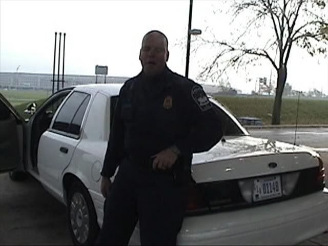
William Lagasse was standing at Pump 2 in the following photo.
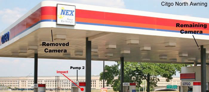
Now you tell me... Would someone familiar with CIT's work make an honest mistake in saying that Lagasse was too far away from the impact site to see anything?
reply to post by discombobulator
The point of my note is that you can argue a point and provide evidence as you just did in your previous post, without being disrespectful and simply saying it is a lie.
It is not the point you made, but it was the manner that you made it. Please show respect to other members even if you don't agree with them. That may fly on other forums, but it doesn't here at ATS.
Also on a general note to all members:
Altering a members name to something demeaning is considered name calling. Please refer to members by their real names.
reply to post by discombobulator
But the plane was much closer to him as it passed by the north of the station.
It's virtually impossible for him to mistake this.
Plus we already know he DIDN'T mistake it because every single other witness in the area backs him up on this, including William Middleton.
Neither Middleton nor Lagasse could possibly mistake the north and south path from their perspectives because they had buildings blocking their view of the south path!
What's more logical....mass hallucination of the banking north side approach or mass deception of the impact?
Also realize that there is clear foreshortening going on with the image you are referencing.
The Pentagon does not appear that close when you are at the gas station.
Here is a better view of the actual perspective and this is from the CLOSER pump!
It's still a good 15 hundred feet away whereas the plane would have passed by him only dozens of feet away.
Of course it would be infinitely easier to mistake the alleged impact.
[edit on 24-9-2008 by Craig Ranke CIT]
Originally posted by discombobulator
Mod Note: Please discuss the topic without resorting to accusing other members of lieing.
Dealing with 9/11 Madness – Please Review This Link.
William Lagasse was standing at Pump 2 in the following photo.
Now you tell me... Would someone familiar with CIT's work make an honest mistake in saying that Lagasse was too far away from the impact site to see anything?
Again, they were much further away. Foreshortened photos do not change that. Go there Disco. You will see, not everything is as closeas it seems in photographs. Reality is a lot different than photography.
May I also remind you that the second Bill Lagasse saw the plane to the left of him or to the north of him, he admitted he FLINCHED and jumped into his patrol car to radio it in in fact, he didn't see the the details of the impact as he admitted because there was a huge fireball.
As for Brooks, he said our movie was an "eye-opener" and that "anything is possible" when it comes to him being fooled that day. Maybe he saw more, maybe he ducked and covered up behind his car. Regardless, he admits our movie was an "eye-opener", he could have been fooled, and most importantly maintains the plane was on the north side of the Citgo which negates an impact.
You can't have both Disco. Or would you like to explain to the audience how the plane showed up low and level across the lawn, hit poles & fence/generator trailer, and caused the directional damage leading to the C-ring hole after it approached on the north side of the Citgo?
[edit on 24-9-2008 by Craig Ranke CIT]
Originally posted by Craig Ranke CIT
Also realize that there is clear foreshortening going on with the image you are referencing.
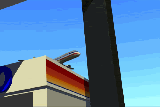
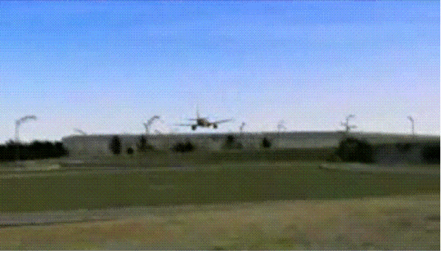
It hilarious that you critique someone using one of YOUR photographs to show a perspective that is a bit unrealistic, YET at the same time you show a .gif that is TOTALLY UNREALISTIC according to ALL of the people at the Citgo Station and ALL of the people from ANC.
I'm talking about this one...
That shows an aircraft perfectly straight and level passing barely North of the Citgo Station. That is NOT what anyone would have seen at all.
Depending upon their location they would have seen either the TOP or the BOTTOM of the aircraft as it turned using an airshow type bank angle. In fact, they would likely have seen the aircraft either stall and crash short of the building or they would have seen the wings fold from excessive G. Then you want to add a pull up to flyover the building which would require more G. Yes, hilarious indeed!
John Farmer has a "new" FAA released flightpath for flight 77, which hit the Pentagon, linked on his latest FOIA page:
aal77.com...
The link:
The controversial FAA/NORAD animation made by AGI's daughter firm STK:
1 AWA 714 pentagon_more2.mpg (mpg file, 12 mb)
aal77.com...
A MUST see! Download and open it with Windows Media Player, let it run one time, stop it just before it ends, and slide the slider slowly back to see the landmarks (crossing roof of NAVY Annex building, north of Citgo gas station, aside Arlington Cemetery with its maintenance buildings) and the right bank of the plane just seconds before "impact".
The video is too fast, but you can slow it down this way very well, or use the slow-down functions of Media Player.
To me it looks much more like a slow flying plane on a perfect landing course to the north tip runway on Reagan International.
If it impacted, it would have cut its right wing 5 meters deep into the Pentagon lawn, before impacting.
If not, it could never have impacted leveled out already a few hundred yards before, as seen in the toll boot cameras DoD videos, at the ceiling of the first floor. Just look up the length of its right wing.
Let ever, to hit that diesel generator as depicted in all those Pentagon photos.
And last but not least, it is totally impossible to have hit those 5 lamp poles at the clover junction roads on a non-existing south of Citgo course.
To obtain some expertise, I went to the PilotsFor911Truth site, and found this informative post in their latest thread:
pilotsfor911truth.org...
This NORAD/FAA data streams-based flightpath has been prepared from May 2002 to June 2002 by AGI, and is already earlier shortly addressed in a PowerPoint presentation of that AGI firm, who made the flightpath video:
www.agi.com...
As being at that time, 2002, for internal use.
See their PP-presentation here:
www.agi.com...
The PowerPoint presentation seems to have been presented to NORAD officials at 11:30 on 06-03-2002.
As an internal memo at that time.
Why did they, the Headquarters of NORAD, knew already at such an early time (March 2002 is the earliest date on the AGI.com papers, six months after 9/11), that flight 77 flew at the North side of the CITGO station, at nearly exactly the same flightpath as described by the 13 witnesses interviewed by the CIT team, and kept quiet about it ALL THESE YEARS ?
Knowing that the basis of the interpretation of the official flightpath, South of CITGO, being the downed 5 light poles and the internal Pentagon damage, which must thus be very questionable also.
And why did NORAD HQ let us getting obsessed in those following six and a half years by all these anomalies in the officially released events timelines and explanations, which turned out now, to be fraudulent from the beginning.
Why did someone decide to give this information free in a FOIA request, at this point in time? Normally the issuing institutions would black this sort of information out, so why not now?
Are some real patriotic Americans being pushed too far and too often over a certain threshold, which they couldn't accept anymore?
A big list of white papers published online by AGI:
www.agi.com...
This is an interesting white paper published by Analytical Graphics, Inc. :
Statistical Analysis of military and civilian navigation error data services
Sept 2005 (180 KB):
www.agi.com...
I hoped to find a likewise researched white paper for other than GPS based data, but until now to no avail.
Reheat wrote that flight 77 had no GPS based navigational systems on board.
I would like to see some references to that, because if they had, than this white paper would be very informative to what amount of error we could base any calculations on. If it had GPS on board, the mean error would be around 78 centimeters minimum to 6 meters maximum (fig 9) in flight data calculations.
One screen shot from the STK PP-presentation, showing the plane flying diagonally over the roof of the Navy Annex building:
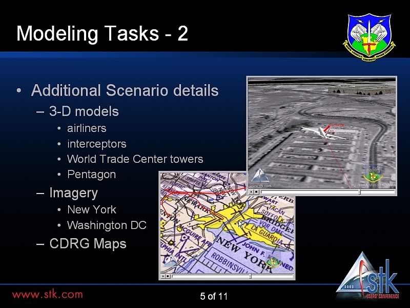
The above AGI-STK video is much better in showing all landmark details and behavior of the plane.
Edit: free PowerPoint viewer:
www.microsoft.com...
[edit on 25/9/08 by LaBTop]
aal77.com...
The link:
The controversial FAA/NORAD animation made by AGI's daughter firm STK:
1 AWA 714 pentagon_more2.mpg (mpg file, 12 mb)
aal77.com...
A MUST see! Download and open it with Windows Media Player, let it run one time, stop it just before it ends, and slide the slider slowly back to see the landmarks (crossing roof of NAVY Annex building, north of Citgo gas station, aside Arlington Cemetery with its maintenance buildings) and the right bank of the plane just seconds before "impact".
The video is too fast, but you can slow it down this way very well, or use the slow-down functions of Media Player.
To me it looks much more like a slow flying plane on a perfect landing course to the north tip runway on Reagan International.
If it impacted, it would have cut its right wing 5 meters deep into the Pentagon lawn, before impacting.
If not, it could never have impacted leveled out already a few hundred yards before, as seen in the toll boot cameras DoD videos, at the ceiling of the first floor. Just look up the length of its right wing.
Let ever, to hit that diesel generator as depicted in all those Pentagon photos.
And last but not least, it is totally impossible to have hit those 5 lamp poles at the clover junction roads on a non-existing south of Citgo course.
To obtain some expertise, I went to the PilotsFor911Truth site, and found this informative post in their latest thread:
pilotsfor911truth.org...
This NORAD/FAA data streams-based flightpath has been prepared from May 2002 to June 2002 by AGI, and is already earlier shortly addressed in a PowerPoint presentation of that AGI firm, who made the flightpath video:
www.agi.com...
As being at that time, 2002, for internal use.
See their PP-presentation here:
www.agi.com...
The PowerPoint presentation seems to have been presented to NORAD officials at 11:30 on 06-03-2002.
As an internal memo at that time.
Why did they, the Headquarters of NORAD, knew already at such an early time (March 2002 is the earliest date on the AGI.com papers, six months after 9/11), that flight 77 flew at the North side of the CITGO station, at nearly exactly the same flightpath as described by the 13 witnesses interviewed by the CIT team, and kept quiet about it ALL THESE YEARS ?
Knowing that the basis of the interpretation of the official flightpath, South of CITGO, being the downed 5 light poles and the internal Pentagon damage, which must thus be very questionable also.
And why did NORAD HQ let us getting obsessed in those following six and a half years by all these anomalies in the officially released events timelines and explanations, which turned out now, to be fraudulent from the beginning.
Why did someone decide to give this information free in a FOIA request, at this point in time? Normally the issuing institutions would black this sort of information out, so why not now?
Are some real patriotic Americans being pushed too far and too often over a certain threshold, which they couldn't accept anymore?
A big list of white papers published online by AGI:
www.agi.com...
This is an interesting white paper published by Analytical Graphics, Inc. :
Statistical Analysis of military and civilian navigation error data services
Sept 2005 (180 KB):
www.agi.com...
My results show that for the military planner, an
operational signal-in-space threshold of greater than 78
centimeters would lead them to choose either the military
or civilian navigation error data service – there is no
statistically significant reason to do otherwise. Below an
operational threshold of 78 centimeters, the military
planner would do better to choose the military data
service. That is the case for only the very near future
however. Within the next month or two, modifications
will be put in place within the civilian navigation error
data service that will bring the level of statistical
significance to approximately 20 centimeters. That is,
with an operational threshold of 20 centimeters or greater,
there is no statistically significant reason to choose one
service over the other.
An additional consideration, based off of the data in
Figures 3 and 4, is the greater variability of the military
errors over that of the civilian errors. While this
increased variability was not enough to affect the
outcome of the statistical tests, it is cause for further
study.
I hoped to find a likewise researched white paper for other than GPS based data, but until now to no avail.
Reheat wrote that flight 77 had no GPS based navigational systems on board.
I would like to see some references to that, because if they had, than this white paper would be very informative to what amount of error we could base any calculations on. If it had GPS on board, the mean error would be around 78 centimeters minimum to 6 meters maximum (fig 9) in flight data calculations.
One screen shot from the STK PP-presentation, showing the plane flying diagonally over the roof of the Navy Annex building:
The above AGI-STK video is much better in showing all landmark details and behavior of the plane.
Edit: free PowerPoint viewer:
www.microsoft.com...
[edit on 25/9/08 by LaBTop]
Originally posted by ULTIMA1
Originally posted by Fitzgibbon
Can you provide an approximate time frame?
Well i received an e-mail the other day. So hopefully here within the next week or 2.
That's one week passed, Ultima. Just want to make sure that you're keeping on top of things.
reply to post by Craig Ranke CIT
Levi Stephens, 23, a courier for the Armed Forces Information Service, refutes the NoC. It flew over him.
"I was driving away from the Pentagon in the South Pentagon lot when I hear this huge rumble, the ground started shaking … I saw this [plane] come flying over the Navy Annex. It flew over the van and I looked back and I saw this huge explosion, black smoke everywhere."
Levi Stephens, 23, a courier for the Armed Forces Information Service, refutes the NoC. It flew over him.
How does it refute the flight going north of Citgo? Genuine question, I'm not just putting this as an 'oh yeah?' challenge. Several of the
witnesses to the northside flightpath also drew the craft as coming over the annex or its facilities. This in no way refutes the northside flightpath.
There is not enough information in that to say that it validates a northside flightpath either, but it certainly doesn't refute it.
Edit: I apologise, I misread the quote, but where abouts was the van (he was driving away) when it flew over him, and how directly above was the flight? Was there a sunroof in the van that he could see directly up from? Or was it some coupé style van? Otherwise, if he was in the van and saw the flight then it must have been at some angle away from the van. Or he was driving with his head out of the window looking directly upwards. This seems a little implausible.
[edit on 28-9-2008 by almighty bob]
reply to post by beachnut
That's why you can't take media reports at face value.
We confirmed with him direct that it did NOT fly over him.
It was a subjective statement that was not meant to suggest DIRECTLY over him.
Of course if it did fly directly over him this would STILL fatally contradict the official flight path since he was in the south parking lot at the time.
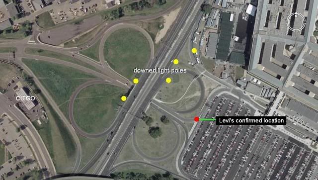
But he DID confirm that it flew directly over the Navy Annex, and was on the Arlington Cemetery or north side of the gas station.
Oh and he thought it did NOT look like an AA jet.
No matter how much denial, spin, and statements you make to the opposite of reality, you can not change the evidence.
By the way did you know that Reheat admitted the NoC flight path is possible?
That's why you can't take media reports at face value.
We confirmed with him direct that it did NOT fly over him.
It was a subjective statement that was not meant to suggest DIRECTLY over him.
Of course if it did fly directly over him this would STILL fatally contradict the official flight path since he was in the south parking lot at the time.
But he DID confirm that it flew directly over the Navy Annex, and was on the Arlington Cemetery or north side of the gas station.
Oh and he thought it did NOT look like an AA jet.
No matter how much denial, spin, and statements you make to the opposite of reality, you can not change the evidence.
By the way did you know that Reheat admitted the NoC flight path is possible?
Thanks Craig, that image answers the question, but from the quote fragment provided by beachnut, doesn't really prove or disprove anything.
However, beachnut, if Stephens did confirm that the flight came north of Citgo (do you have a direct quote of this, Craig? Or any testimony from Stephens?) then this is, at best, ill researched grasping at a pattern to fit your theory, at worst deliberate deception and misinformation that should cast doubt on any argument you make.
Besides, even if his statement did show evidence as you intended it to be read in your post, you still need thirteen more witnesses (as per the conditions of the northside witness statements, impartial and untainted) to actually refute the northside flyover.
Originally posted by Craig Ranke CIT
9. Terry Morin
He describes the plane as directly over him.
We knew that if he meant this literally it would support the north side flight ...
This fact alone proves that he supports the north side path.
He says he then ran out from between the wings and saw the tail of the plane as it reached the Pentagon.
The obvious problem with this claim is that you can only see the very top of the Pentagon from the Navy Annex ...
Since the physical damage requires the plane to enter the building at the bottom floor this means ...
What also contradicts the official story is the fact that like William Middleton and Sean Boger, Terry believes the plane was going a lot slower than officially reported. ...
His story still refutes north path. He explains it is over him and the outer edge of the FOB, and the flight path is parallel to that outer edge as he is going south. South path. Geometry comes in handy.
The aircraft was essentially right over the top of me and the outer portion of the FOB (flight path parallel the outer edge of the FOB)." Morin says!
If the plane passes directly over Morin over the Annex, and goes north of the CITGO, you need 7.66 Gs (wings rip off) with 82.5 degree of bank. IMPOSSIBLE AGAIN
Morin sees the tail, the tail is over 9 feet over the nose of 77, due to descent, thus he see no flyover, 77 is too far below the Pentagon when Morin see the tail to pull out. Morin essentially see the impact, a NoC would not let him see anything due to the Annex being in the way. Geometry steps in to make your interpretation of Morin not correct.
The physical damage at the Pentagon was caused by 77 when it impacted just at or below the Junction of the 1st and 2nd floor. The tail is 44 feet tall, 77 impacts at just below, as in at, the 1st and 2nd floor sections, this means the tail of 77 has the 9 feet above the ground, the 9 feet of up angle for the descent, and 44.5 feet. 62.5 feet tall tail at impact. Morin did see the tail at impact, geometry wins this one.
A fly over? Morin would see the whole plane, not the tail after the plane went down out of sight.
Morin makes a flyover impossible; all the People who witnessed 77 impact; Boger is one who actually watched 77 enter the Pentagon; have you told Boger you are calling him a liar?
Middleton supports impact; no flyover.
William Middleton, sweeper who was less then a mile from the Pentagon:
”I looked up and spotted a commercial jet whose pilot seemed to be fighting with his own craft. Middleton said the plane was no higher than the tops of telephone poles as it lurched toward the Pentagon. The jet accelerated in the final few hundred yards before it tore into the building."
To claim a slower speed than 77 is not even possible based on the damage to the Pentagon done by 77. The kinetic energy impact, and the damage is consistent with the speed of 77, with energy of 1121 pounds of TNT. So the damage to the Pentagon confirms the speed of 77. Physics can be used to check this. Why not read the Pentagon Building Performance report. fire.nist.gov...
[edit on 28-9-2008 by beachnut]
reply to post by almighty bob
To be honest bob out of the 13 north side witnesses, 2 would not give us permission to release the interviews. Levi Stephens and Terry Morin.
Naturally this is why Beachnut chooses to focus on these two.
So consider it 11 if you want but we stake our entire reputations on how we have reported Levi Stephens and Terry Morin's accounts and we are quite certain they would speak out against us if we had misrepresented what they said.
But you can hear the words come directly from the mouths of all 11 other north side witnesses, most of whom were filmed on location.
A shame, yes. Like Roosevelt Roberts, I can't really objectively view it as more than hearsay. But given the veracity of your investigation in
general, I realise it would be counterproductive, and downright damning against the entire venture for you to have faked the information.
Regardless, until a greater refutation using the terms of the CIT investigation arises (that is to say, independant and impartial witness testimony againts the hypothesis), 11 witnesses is still more than enough for validation of the northside flightpath theory.
Regardless, until a greater refutation using the terms of the CIT investigation arises (that is to say, independant and impartial witness testimony againts the hypothesis), 11 witnesses is still more than enough for validation of the northside flightpath theory.
new topics
-
Electrical tricks for saving money
Education and Media: 1 hours ago -
VP's Secret Service agent brawls with other agents at Andrews
Mainstream News: 2 hours ago -
Sunak spinning the sickness figures
Other Current Events: 3 hours ago -
Nearly 70% Of Americans Want Talks To End War In Ukraine
Political Issues: 3 hours ago -
Late Night with the Devil - a really good unusual modern horror film.
Movies: 5 hours ago -
Cats Used as Live Bait to Train Ferocious Pitbulls in Illegal NYC Dogfighting
Social Issues and Civil Unrest: 6 hours ago -
The Good News According to Jesus - Episode 1
Religion, Faith, And Theology: 8 hours ago -
HORRIBLE !! Russian Soldier Drinking Own Urine To Survive In Battle
World War Three: 10 hours ago
top topics
-
SETI chief says US has no evidence for alien technology. 'And we never have'
Aliens and UFOs: 17 hours ago, 8 flags -
Cats Used as Live Bait to Train Ferocious Pitbulls in Illegal NYC Dogfighting
Social Issues and Civil Unrest: 6 hours ago, 8 flags -
Florida man's trip overseas ends in shock over $143,000 T-Mobile phone bill
Social Issues and Civil Unrest: 13 hours ago, 8 flags -
VP's Secret Service agent brawls with other agents at Andrews
Mainstream News: 2 hours ago, 7 flags -
Former Labour minister Frank Field dies aged 81
People: 15 hours ago, 4 flags -
Bobiverse
Fantasy & Science Fiction: 13 hours ago, 3 flags -
HORRIBLE !! Russian Soldier Drinking Own Urine To Survive In Battle
World War Three: 10 hours ago, 3 flags -
Nearly 70% Of Americans Want Talks To End War In Ukraine
Political Issues: 3 hours ago, 3 flags -
Sunak spinning the sickness figures
Other Current Events: 3 hours ago, 3 flags -
Late Night with the Devil - a really good unusual modern horror film.
Movies: 5 hours ago, 2 flags
active topics
-
The Reality of the Laser
Military Projects • 45 • : 5thHead -
President BIDEN Vows to Make Americans Pay More Federal Taxes in 2025 - Political Suicide.
2024 Elections • 125 • : ImagoDei -
Cats Used as Live Bait to Train Ferocious Pitbulls in Illegal NYC Dogfighting
Social Issues and Civil Unrest • 13 • : Albone -
Spectrophilia - Women Who Have Had Affairs With Ghosts Say Spooks Are Better Lovers Than Real Men
Paranormal Studies • 31 • : charlyv -
HORRIBLE !! Russian Soldier Drinking Own Urine To Survive In Battle
World War Three • 29 • : doubledan717 -
-@TH3WH17ERABB17- -Q- ---TIME TO SHOW THE WORLD--- -Part- --44--
Dissecting Disinformation • 651 • : 777Vader -
VP's Secret Service agent brawls with other agents at Andrews
Mainstream News • 19 • : NoCorruptionAllowed -
VirginOfGrand says hello
Introductions • 5 • : burritocat -
SETI chief says US has no evidence for alien technology. 'And we never have'
Aliens and UFOs • 42 • : Boomer1947 -
NASA Researchers Discover a Parallel Universe That Runs Backwards through Time - Alongside Us
Space Exploration • 71 • : charlyv