It looks like you're using an Ad Blocker.
Please white-list or disable AboveTopSecret.com in your ad-blocking tool.
Thank you.
Some features of ATS will be disabled while you continue to use an ad-blocker.

Beaumont, CA Lockheed
page: 2share:
Hey guys. I have access to the gate at the potrero site and have been throughout there many times and have camped at temple bethel recently. About 6
months ago we spotted a black suburban. We ran like bats out of hell. We decided to drive back over when they turned around. We talked to them who
questioned how we got a car and a 2wd truck in there then angrily told us to leave. We left but i haven't seen them the last 10 times I've been there,
The name on the side of the truck was tetra tech. A bomb squad and ground sample company.
Anyways, there is one single bunker still active on the property. Lights at night, video, audio, locked steel doors and ac. Somewhat suspicious. But im curious about laborde. Thinking about checking it out in a couple of days. Is Anyone in the area that knows of roads that lead to the laborde site? Id appreciate it!
Anyways, there is one single bunker still active on the property. Lights at night, video, audio, locked steel doors and ac. Somewhat suspicious. But im curious about laborde. Thinking about checking it out in a couple of days. Is Anyone in the area that knows of roads that lead to the laborde site? Id appreciate it!
edit on 16-10-2014 by Arrow94 because: (no reason given)
edit on 16-10-2014 by Arrow94 because: (no reason
given)
a reply to: richpowers
TAKE A WILD RIDE THROUGH LABORDE CANYON, BEAUMONT, CALIFORNIA, ON LOCKHEED PROPULSION COMPANY SITE 2,
Go inside a rocket test site observation bunker, and when leaving the bunker, get a quick glimpse of the PRISM on your right with motocross tracks going over the top. Ride the knife edge ridges of the bad lands. See the Gas Company high pressure gas line (fenced off at top of hill). What do you do when your dirt bike gets stuck on the edge of a cliff?
Go to You Tube: Riding Beaumont Hills California- Motocross
Hooray, now you can really see for yourself why they call this area, "The Bad Lands".
Rich
a reply to: Arrow94
How does one get into LaBorde Canyon, Beaumont, California?
WARNING: YOU WILL ENTER THE BAD LANDS.
Take at least 2 or 3 appropriate all wheel drive vehicles (equipped with roll cage, tow ropes, extra food, water , compass, mobile phone, and first aid kits; this area is treacherous). Your mobile phone might get a signal from a high ridge where you can see the city below. Off road dirt bikes are your best way to get around in that rough terrain with narrow canyons with walls that go almost straight up.
Tell your friends where you are going and if they do not hear from you by night fall, to call the Riverside County Sheriff search and rescue. This is a huge area and people have gotten lost up there.
There are poisonous diamond back rattle snakes in that area. Diamond backs blend in to the surroundings. If you see one, stay away, they can strike faster than the blink of an eye. Wear tall boots with 2 pair of sox and watch your step. You can scare off coyotes and bobcats by yelling and throwing stones at them. But your biggest fear is falling down one of the steep ravines and getting injured.
But of course, you already knew all that and really want to go to this wilderness. OK, so lets get started:
Access From the Beaumont side (north side)
Jack Rabbit Trail off ramp off California State 60 Freeway. You must be traveling going east because there is no exit there going west. From Jack Rabbit Trail (not a maintained road), look for trails heading east.
Off that same exit you may be able to enter LaBorde canyon on a better road, but it goes through private property. This is the way Lockheed Propulsion Company came in back when they owned the Gate Way Property there. Maybe if the gate is open you can go straight in. Please be respectful of other people's property and do not cut off the lock with bolt cutters.
Access from the south side, San Jacinto side.
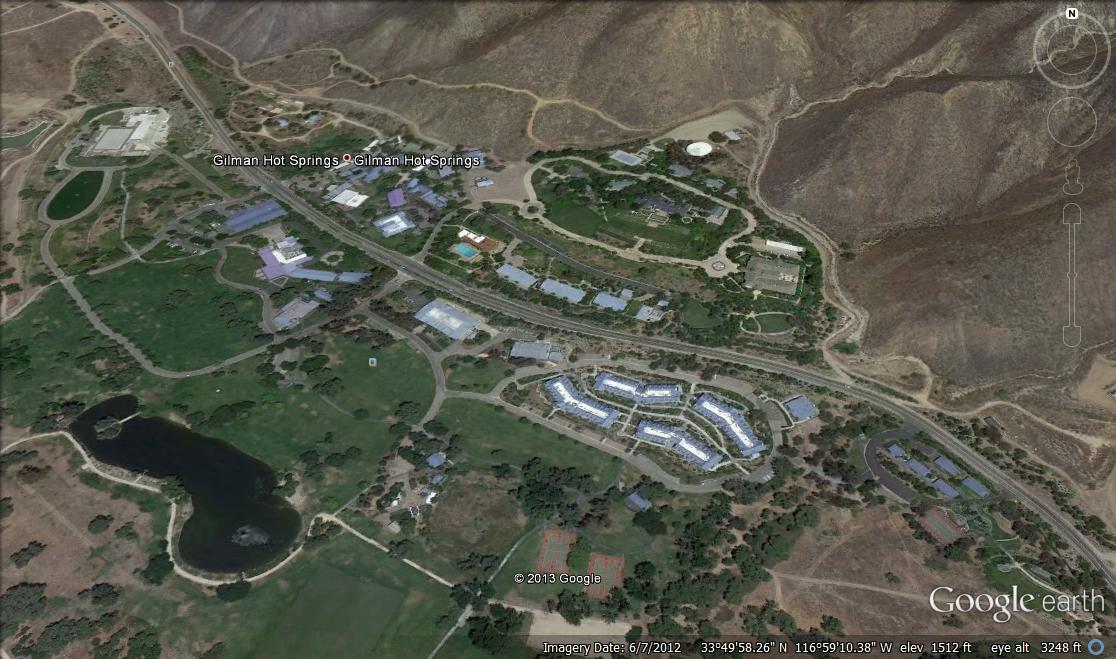
Take Gilman Hot Springs Rd east past Massacre Canyon, take Jack Rabbit Trail north all the way to 60 freeway and look for trails going east.
Jack Rabbit Trail is a public county road, but is not a maintained road and can be treacherous. It goes through the BAD LANDS is frequently impassable from land slides and wash outs. The Gas Company has large high pressure pipes running up through there. The Gas Company, being a public utility, can make Riverside County Road Maintenance make Jack Rabbit Trail a passable road once in a while, so they can maintain those big gas lines. So if it is your lucky day, the road will be passable and you will be able to get where you want to go.
Thankfully, someone transversed Jack Rabbit Trail, in 2013, by motorcycle and took pictures.
socalregion.com...
Of course you can use Google maps and see that Jack Rabbit Trail comes off of Gilman Hot Springs Road just east of Eden Hot Springs Rd (Canadian Hot Springs). Yeah, and click on that tab in the lower left corner that says Earth and see the satellite view.
Take care and take pictures for us off all those test sites, old foundations, bunkers and the PRISM. Post them online and tell us where we can view them. I really miss going out there, but at my age I just can't do it anymore.
Thanks, Rich
How does one get into LaBorde Canyon, Beaumont, California?
WARNING: YOU WILL ENTER THE BAD LANDS.
Take at least 2 or 3 appropriate all wheel drive vehicles (equipped with roll cage, tow ropes, extra food, water , compass, mobile phone, and first aid kits; this area is treacherous). Your mobile phone might get a signal from a high ridge where you can see the city below. Off road dirt bikes are your best way to get around in that rough terrain with narrow canyons with walls that go almost straight up.
Tell your friends where you are going and if they do not hear from you by night fall, to call the Riverside County Sheriff search and rescue. This is a huge area and people have gotten lost up there.
There are poisonous diamond back rattle snakes in that area. Diamond backs blend in to the surroundings. If you see one, stay away, they can strike faster than the blink of an eye. Wear tall boots with 2 pair of sox and watch your step. You can scare off coyotes and bobcats by yelling and throwing stones at them. But your biggest fear is falling down one of the steep ravines and getting injured.
But of course, you already knew all that and really want to go to this wilderness. OK, so lets get started:
Access From the Beaumont side (north side)
Jack Rabbit Trail off ramp off California State 60 Freeway. You must be traveling going east because there is no exit there going west. From Jack Rabbit Trail (not a maintained road), look for trails heading east.
Off that same exit you may be able to enter LaBorde canyon on a better road, but it goes through private property. This is the way Lockheed Propulsion Company came in back when they owned the Gate Way Property there. Maybe if the gate is open you can go straight in. Please be respectful of other people's property and do not cut off the lock with bolt cutters.
Access from the south side, San Jacinto side.
Take Gilman Hot Springs Rd east past Massacre Canyon, take Jack Rabbit Trail north all the way to 60 freeway and look for trails going east.
Jack Rabbit Trail is a public county road, but is not a maintained road and can be treacherous. It goes through the BAD LANDS is frequently impassable from land slides and wash outs. The Gas Company has large high pressure pipes running up through there. The Gas Company, being a public utility, can make Riverside County Road Maintenance make Jack Rabbit Trail a passable road once in a while, so they can maintain those big gas lines. So if it is your lucky day, the road will be passable and you will be able to get where you want to go.
Thankfully, someone transversed Jack Rabbit Trail, in 2013, by motorcycle and took pictures.
socalregion.com...
Of course you can use Google maps and see that Jack Rabbit Trail comes off of Gilman Hot Springs Road just east of Eden Hot Springs Rd (Canadian Hot Springs). Yeah, and click on that tab in the lower left corner that says Earth and see the satellite view.
Take care and take pictures for us off all those test sites, old foundations, bunkers and the PRISM. Post them online and tell us where we can view them. I really miss going out there, but at my age I just can't do it anymore.
Thanks, Rich
a reply to: richpowers
LaBorde Canyon, Site 2, Lockheed Propulsion Company, Beaumont, California
Yes, there is another way in from the south side, off of Gilman Springs Rd, take LaBorde Canyon (I don't know if there is a street sign or just a road going up to the north). I do not know if this is a gated private road. It goes up the canyon and soon becomes a jeep trail.
I found the best 3D image map:
itouchmap.com...
This 3D map is so good that it seems as if you are driving right up into LaBorde Canyon. You can see the PRISM and the Bunker and big foundation of the rocket assembly plant. You can use the tools on the right to make image larger or smaller and turn your view point so you are looking north, south, east or west. Try it, you'll like it.
Rich
a reply to: richpowers
Lockheed, Beaumont, LaBorde Canyon entrance from the south off Gilman Springs Rd.
This gets a little tricky, but if you are an off roader, maybe no problem.
There is a sturdy gate on the LaBorde Canyon entrance. Now, I am not telling you to trespass, that is up to you.
To get around this gate, go east and take the next road to your right, then turn right again on the power line road coming back east and meet up with LaBorde Canyon on the other side of the gate. I did not see any structures up there, like houses so probably no people live up there to chase you out.
Stay to the left to get up to the abandoned rocket test site. The road turns into a jeep trail. Do not take the big road to the right, because that is a power line road and wont take you into the rocket test site.
Good Luck
Rich
a reply to: Arrow94
Hey Arrow94,
Next time you get out to the Lockheed Rocket Company, Potrero Canyon Site, Beuamont, California,
Please check out this man hole located at:
33 degrees, 51' 02.38" North, 116 degrees, 55" 38.14 West
Check it out on Google Earth (maps).
There is a man made mound of subsoil about 100 yards from there about 5 stories tall and the base is about the size of a football field. An enormous amount of rocks was dug out of the earth.
I think it is the, 800 foot deep, Potrero Shaft, dug by MWD in the early 1930's to assist with the construction of the San Jacinto Tunnel.
Check out this nifty tunnel map:
www.usbr.gov/lc/hooverdam/museum/clippings/clipart771.pdf
Ref:
The following was cut and pasted from
Riverside Press Enterpise
SAN JACINTO MOUNTAINS: Tunnel a 1930s engineering feat
"Two vertical shafts were excavated to the grade level of the tunnel at Cabazon on the east and at Potrero on the west,â in addition to portals at each end of the tunnel, said âOdyssey.â The Potrero shaft was 800 feet deep, according to âColorado River Aqueduct Recording Project 1998,â another MWD history.
Excavation proved unexpectedly difficult. âThe mountainâs interior was laced with subsurface faults, streams and springs,â noted âOdyssey.â In July 1934, workers from the west portal hit an underground stream.
âOver 7,500 gallons per minute of water, accompanied by 1,000 cubic yards of detritus, rushed into the tunnel and rose to a depth of 647 feet in the Potrero shaft,â said âRecording Project.â The water was pumped out, but a second flood overwhelmed two of the three pumps."
Well, now we know for sure, that there is water (and earthquake faults) under the Potrero rocket test site. Making it an unlikely place to build an underground facility.
Its probably a bad idea to go down the ladder into the 800 foot shaft. Probably a lot of water rushing through the tunnel at the bottom.
Well, what do you think?
Why not take some photos of this place and let us know on where you posted them online. Plus photos of those old foundations next to the manhole.
Inquiring minds want to know.
Rich
a reply to: Cauliflower
Hi Cauliflower,
Thanks for your input.
The co-ordinates you gave us put us on a road on the abandoned Lockheed Propulsion Company, Potrero Canyon, Site 1, Beaumont, California.
The MWD Colorado River Aquaduct passes under this property at a different location. Please read below:
Please check out this man hole located in the middle of the road at:
33.8480194,-116.9271197
Check it out on Google Earth (maps).
There is a man made mound of subsoil about 100 yards from the man hole about 5 stories tall and the base is about the size of a football field. An enormous amount of rocks was dug out of the earth.
I think it is the, 800 foot deep, Potrero Shaft, dug by MWD in the early 1930's to assist with the construction of the San Jacinto Tunnel. However, the amount of debris piled up is obviously a lot more than would be needed to dig a shaft 3' diameter and 800' deep. Even if they made the shaft 12' in diameter, that mound is a lot more earth than would have been dug out of the shaft. I don't like to guess, but maybe MWD brought up rock debris from the tunnel through the shaft.
I don't have time to contact MWD and ask them about that shaft. If you get more info, please post it here.
Check out this nifty tunnel map:
www.usbr.gov/lc/hooverdam/museum/clippings/clipart771.pdf
Ref:
The following was cut and pasted from
Riverside Press Enterpise
SAN JACINTO MOUNTAINS: Tunnel a 1930s engineering feat
"Two vertical shafts were excavated to the grade level of the tunnel at Cabazon on the east and at Potrero on the west,â in addition to portals at each end of the tunnel, said âOdyssey.â The Potrero shaft was 800 feet deep, according to âColorado River Aqueduct Recording Project 1998,â another MWD history.
Excavation proved unexpectedly difficult. âThe mountainâs interior was laced with subsurface faults, streams and springs,â noted âOdyssey.â
Thanks Cauliflower and please keep in touch.
Rich
a reply to: Arrow94
Arrow94
i hope you get these directions in time for your trip to lockheed abandoned rocket test site in laborde canyon.
I got these ref points from Google Earth, you should try it too.
YOU WILL NEED A CUMPAS, and if you can afford it GPS connected to satellite. Mobile phones my not find a connection in steep hilly terrain. Maybe you can get a signal on a high ridge.
There are two ways in:
if Jack Rabbit Trail is impassable from Gilman Springs Rd on the south , then try to get in from the 60 freeway on the north
Start your trip early in the morning in case you have to have to try a different way in.
It is easy to get lost so write down land marks and distances.
DO NOT STAND NEAR THE SIDE OF THE ROAD WHERE THERE ARE CLIFFS WHERE MOUNTAIN LIONS CAN JUMP DOWN ON TOP OF YOU.
WATHC FOR RATTLE SNAKES.
ALWAYS TAKE TWO VEHICLES WITH TOW ROPES AND POWERFUL CB RADIOS.
GET OUT OF THERE WAY BEFORE IT GETS DARK.
From the south end of Jack Rabbit Trail off of Gilman Springs Rd, in San Jacinto area.
From Freeway 60, Jack Rabbit Trail exit may be shorter and and probably less confusing.
FROM GILMAN SPRINGS ROAD:
Take jack rabbit trail off Gilman Springs rd at 33.889582, -117.070769 head north on Jack Rabbit Trail for at least 5 miles.
On jackrabbit trail at 33.919012, -117.051370 , you will see big gas company pipe (COULD BE HIDDEN AROUND THE BEND); take jeep trail east and wind the hills for approx 1.5 miles,
At 33.919012, -117.051370 make a right turn and go south east and twist and turn.
then go about a mile and turn right at 33.914801, -117.029982 and go south east
then go 500 feet and just past an abandoned pavement on left, turn right at 33.914759, -117.029940 and go due south 200 feet.
You should see the big flat concrete foundation of the abandoned rocket assembly building on right at 33.913263, -117.029254
Continue on same trail due south for about half a mile, take the trail on right at 33.906445, -117.029587
and you will go to the huge earthen mound called the PRISM on the left of the road at 33.908457, -117.031569
and just past that on your left you will see the concrete bunker covered in graffiti at 33.909133, -117.032558
GET OUT OF THERE WELL BEFORE DARK.
FROM 60 FREEWAY NEAR BEAUMONT 33.933694, -117.033616
Exit 60 freeway and keep right and go up slight grade ; now you are on Jack Rabbit Trail.
At the locked farm house gate make a sharp right and stay on Jack Rabbit Trail about 3 - 4 miles of turns until you see the big gas pipe up on the hill on your left (east) and turn left and go east at 33.919012, -117.051370All
At 33.919012, -117.051370 make a right turn and go south east and twist and turn.
then go about a mile and turn right at 33.914801, -117.029982 and go south east
then go 500 feet and turn right just past an abandoned pavement on left at 33.914759, -117.029940 and go due south 200 feet.
You should see the big flat concrete foundation of the abandoned rocket assembly building on right at 33.913263, -117.029254
Continue on same trail due south for about half a mile, take the trail on right at 33.906445, -117.029587
and you will go to the huge earthen mound called the PRISM on the left of the road at 33.908457, -117.031569
and just past that on your left you will see the concrete bunker covered in graffiti at 33.909133, -117.032558
LEAVE THERE WELL BEFORE IT GETS DARK.
directions are approximate, so if you end up in Beverly Hills, well uhh, don't blame me. Any way, you will probably want to view this on GOOGLE EARTH before you leave.
Please take lots of pictures for all of us at ABOVE TOP SECRET and let us know where to find them online.
Inquiring Minds Want To Know,
rich
Hi there. I will most definitely check those coordinates for the shaft out when i go back in two weeks. Ill open it up and let you guys know if i hear
water rushing down there. As far as laborde i went out and tried to find it saturday night at around midnight. I took gilman springs and just drove
slow until i saw a big black gate. When i saw the hazardous chemical sign i knew it was the right road. Since the key for the other gate didnt work
for this one we kept going. I turned right onto the road that i now know goes to the 60 and stopped at the high pressure gas pump thing. Then we
followed the road even further all the way until it turned to dirt. Since i didnt know what the dirt trail looked like ahead nor was i aware it went
to the 60 i had one option. Back my truck 2 miles down that sketchy cliff ridden road till i found a turnaround area at about 1:30 in the morning. I
then realized i lost my phone but gladly and luckily found it at the gas pipeline. Then i found the dirt road that leads to the inside of the gate.
We followed that road up until you get to the fork in the road with all the bee boxes. At that point it was almost 3 am, we were all tired, i was low
on fuel and so we decided to head home. I will come from the 60 next time. Thanks to your coordinates i found the site and the trip from the 60 looks
to be a much easier venture!
edit on 20-10-2014 by Arrow94 because: (no reason given)
a reply to: richpowers
Hi there. I realize i have been to that manhole. I can almost confirm that it is the shaft. It isn't a manhole but a very large cement block with a steel padlocked trap door type thing on top. Now that i know what it is i kinda want to open it up and check it out.
Hi there. I realize i have been to that manhole. I can almost confirm that it is the shaft. It isn't a manhole but a very large cement block with a steel padlocked trap door type thing on top. Now that i know what it is i kinda want to open it up and check it out.
a reply to: Cauliflower
Hi Cauliflower:
I am glad I have somebody to talk to. I did some research on the web about that man hole on the south eastern portion of the vast 9,100 acre, Lockheed Propulsion Company, Potrero Canyon Site 1, at 33.848120, -116.927020
and the five story tall pile of subsoil near by at 33.851277, -116.927492.
I am pretty sure it is the Potrero shaft, of the San Jacinto tunnel for the MWD Colorado River aqueduct. I found out that the reason that there is so much material there, is because it is from the tunnel. MWD started tunneling from the bottom of the Potrero shaft and brought the tunneling debris up the shaft to the surface and dumped it in that huge pile there.
Ref: Eastern Municipal Water District records. www.emwd.org...
See page 6 of the document.
Can you imagine the huge elevator they must have had to hoist the tunneling debris up the 800 foot shaft and then dump it into narrow gage railroad cars to carry it away?
Ok, so now we know a little more about an interesting artifact found at the Lockheed Propulsion Company, Potrero rocket manufacturing and test site #1.
Rich
a reply to: Arrow94
Hey Arrow94,
I am happy you replied and gave us some real meat to chew on.
Please take some digital photos of this Shaft and the old foundations to the east of it. Please take some pix of that big huge pile of tunnel debris from different angles.
Yeah and please post your photos on line and tell us where to find them.
Happy off roading
Rich
a reply to: Arrow94
WOW, Arrow94, did you really go up into the BAD LANDS in the dark? I mean, THAT IS DANGEROUS MAN! You are scaring me. We need you. You are the point man for our BEYOND TOP SECRET EXPLORATION TEAM. I know people get lost up there. Not only that, you can't see where water has undermined the road and the road could collapse sending you down into one of those steep ravines.
ARROW94, from now on, please drive while the sun shines.
I AM OK NOW, I JUST TOOK A BREAK TO PULL MYSELF TOGETHER, AFTER YOU TOLD ME WHAT YOU DID.
We need you to go back up in there again, IN THE DAYTIME, and take lots of pix and show them to us.
Thanks for sharing
Rich
a reply to: richpowers
Hi rich. I most certainly will get some pictures. Ill even go as far as to open it and get an inside shot of the shaft for you guys.
And yes i went at night. Im just that crazy haha. Your talking to a guy who hiked over 10 miles to camp in a canyon at 1:30 in the morning then woke up and hiked 15 more miles back into the canyon till i hit a dead end. I later found out from my picture locations that i hiked from cabazon to the outskirts of idylwild. I have experience with bobcats and mountain lions and the most dangerous rattlesnake there is in california. I have spent years reading roads due to my driving style which requires it, and i can assure you, i wouldn't take a chance on something that doesn't look right. Im a very adventurous but safe person
Needless to say though, i will be going back in bout a week and a half, and most definitely will check out laborde, during the DAYTIME. I really just wanted to find the entrance that night, because my daytime exploration saturday was haulted by a bad alternator which died out at potrero. Luckily my buddy was with me to charge my batt with his car.
Anyways, if anyone in the area is interested, id be willing to take you out to potrero next time im there. Just let me know. I actually have legal access to that one.
Maybe one of you could shed some light on the bunker at potrero which remains locked, with power, and cameras still active
edit on 21-10-2014 by Arrow94 because: Added some stuff
a reply to: Arrow94
Hey Arrow94, count me in on your next trip to Potrero.
I made a special email account just for this trip (in case I get a lot of unwanted emails)
[email protected]
Arrow94, email me the details, date, time, and where we will meet.
I will rent a cheap old beat up jeep from RelayRides.com and bring two other ATS fans with me.
Arrow94, Hope to hear from you soon.
Rich
a reply to: Cauliflower
Sorry, this reply was already posted and so I deleted it.
Rich
Sorry, this reply was already posted and so I deleted it.
Rich
edit on 21-10-2014 by richpowers because: Sorry, this reply was already posted and so I deleted it. Rich
a reply to: richpowers
Hi rich. Ok i will work something out. The days i will be in town are october 31st and november 1st. Friday and saturday. I am arriving friday afternoon and leaving sunday night. I will talk to the person i got the access from originally, just to ok the idea and see if he wants to come(hes the guy who was with me on that night in laborde) i will email you momentarily.
Hi rich. Ok i will work something out. The days i will be in town are october 31st and november 1st. Friday and saturday. I am arriving friday afternoon and leaving sunday night. I will talk to the person i got the access from originally, just to ok the idea and see if he wants to come(hes the guy who was with me on that night in laborde) i will email you momentarily.
What a strange and interesting thread!
It's curious that I stumbled upon it today, as I just Drove through there today, for the first time. I just recently moved to Hemet. Took Sanderson to Gilman Springs, Allessandro over to Morreno Valley. I was imagining how fun those hill would be on a bike!
Anyway, I was drawn to the thread because of the Lockheed Jet Propulsion info and my spidey sense about that area. The Church of Scientology has a huge fortress just south east of Beaumont, off Gilman Springs. They're big on underground compounds, by the way. And then of course, there's L R Hubbard, who teamed up with Jack Parson and all.
Anyway, I hope you keep posting to the thread, your outing and info.
BUMP
a reply to: windword
Hi there. That scientology compound is actually the international headquarters for the entire religion. Every movie, song, or commercial is filmed and produced there. Then distributed to all the smaller compounds and churches for the members to watch or listen to. People have even escaped from there. The niece of the president i think her name was jenny or something escaped from there
Hi there. That scientology compound is actually the international headquarters for the entire religion. Every movie, song, or commercial is filmed and produced there. Then distributed to all the smaller compounds and churches for the members to watch or listen to. People have even escaped from there. The niece of the president i think her name was jenny or something escaped from there
a reply to: Arrow94
Hiya back!
Yeah. Jenna Miscaviage escaped. Now David Miscaviage's wife is "missing" and the reason why Leah Remini left the church. The Gilman Springs compound is known for The Hole , where bad little Scientologists are sent for rehabilitation.
Golden Era Productions
But, watchout! They're watching you!
More on that here: angrygaypope.com...
edit on 21-10-2014 by windword because: (no reason given)
new topics
-
In an Historic First, In N Out Burger Permanently Closes a Location
Mainstream News: 1 hours ago -
MH370 Again....
Disaster Conspiracies: 2 hours ago -
Are you ready for the return of Jesus Christ? Have you been cleansed by His blood?
Religion, Faith, And Theology: 4 hours ago -
Chronological time line of open source information
History: 5 hours ago -
A man of the people
Diseases and Pandemics: 6 hours ago -
Ramblings on DNA, blood, and Spirit.
Philosophy and Metaphysics: 7 hours ago -
4 plans of US elites to defeat Russia
New World Order: 8 hours ago
top topics
-
Israeli Missile Strikes in Iran, Explosions in Syria + Iraq
World War Three: 15 hours ago, 17 flags -
In an Historic First, In N Out Burger Permanently Closes a Location
Mainstream News: 1 hours ago, 12 flags -
Thousands Of Young Ukrainian Men Trying To Flee The Country To Avoid Conscription And The War
Other Current Events: 12 hours ago, 7 flags -
Iran launches Retalliation Strike 4.18.24
World War Three: 15 hours ago, 6 flags -
12 jurors selected in Trump criminal trial
US Political Madness: 14 hours ago, 4 flags -
4 plans of US elites to defeat Russia
New World Order: 8 hours ago, 4 flags -
A man of the people
Diseases and Pandemics: 6 hours ago, 4 flags -
Chronological time line of open source information
History: 5 hours ago, 2 flags -
Are you ready for the return of Jesus Christ? Have you been cleansed by His blood?
Religion, Faith, And Theology: 4 hours ago, 2 flags -
MH370 Again....
Disaster Conspiracies: 2 hours ago, 1 flags
active topics
-
In an Historic First, In N Out Burger Permanently Closes a Location
Mainstream News • 5 • : underpass61 -
12 jurors selected in Trump criminal trial
US Political Madness • 50 • : Xtrozero -
Do we live in a simulation similar to The Matrix 1999?
ATS Skunk Works • 24 • : ByeByeAmericanPie -
4 plans of US elites to defeat Russia
New World Order • 32 • : Oldcarpy2 -
Thousands Of Young Ukrainian Men Trying To Flee The Country To Avoid Conscription And The War
Other Current Events • 22 • : Xtrozero -
Fossils in Greece Suggest Human Ancestors Evolved in Europe, Not Africa
Origins and Creationism • 69 • : Xtrozero -
George Knapp AMA on DI
Area 51 and other Facilities • 24 • : Raptured -
Marjorie Taylor Greene Files Motion to Vacate Speaker Mike Johnson
US Political Madness • 63 • : WeMustCare -
Are you ready for the return of Jesus Christ? Have you been cleansed by His blood?
Religion, Faith, And Theology • 13 • : Cvastar -
MH370 Again....
Disaster Conspiracies • 4 • : Vermilion