It looks like you're using an Ad Blocker.
Please white-list or disable AboveTopSecret.com in your ad-blocking tool.
Thank you.
Some features of ATS will be disabled while you continue to use an ad-blocker.

Hurricane watch 2008
page: 2share:
HAMILTON, Bermuda (AP) — Slow-moving Bertha barely clung to its hurricane status as it hovered near Bermuda early Sunday, and forecasters said it could weaken to tropical storm status by the end of the day.
The Bermuda Weather Service issued a tropical storm warning as Bertha's outer bands were expected to brush the island in the coming days.
usatoday
Please visit the link provided for the complete story.
Well it seems to be fizzling out, and thats a good thing!!
While Bertha spins nearly on top of Bermuda right now, there's another tropical low that bares watching. Still a few days away from the Caribbean,
but heads up. This could be a depression within the next 24 hours, and there's nothing really blocking it from developing further.
Current path projections:

NHC outlook:
[edit on 14-7-2008 by ThatsJustWeird]
Current path projections:
NHC outlook:
THUNDERSTORM ACTIVITY WITH THE AREA OF LOW PRESSURE LOCATED ABOUT 1200 MILES EAST OF THE LESSER ANTILLES HAS INCREASED A LITTLE SINCE THIS MORNING. ENVIRONMENTAL CONDITIONS ARE FAVORABLE FOR FURTHER DEVELOPMENT...AND THIS SYSTEM COULD BECOME A TROPICAL DEPRESSION AT ANY TIME DURING THE NEXT DAY OR TWO AS IT MOVES WEST-NORTHWESTWARD AT 15 MPH.
[edit on 14-7-2008 by ThatsJustWeird]
That wave ^ is still there but still not a depression yet. Still a bit disorganized.
On the other side of the Caribbean, there's a tropical wave that is starting to show some signs of organization and will have to be watched. Close to land though so it may run out of real estate.
And there's a low that developed half over water and half over Florida. If it moves completely over water, this too will have to be watch.
Bertha is also still out there spinning away. Winds up to 70 again.
Only one organized storm but lots to watch out there.
In the Pacific, TD 7 just formed.
reply to post by ThatsJustWeird
Whats your opinion of this hurricane season so far? And what do you expect in the future?
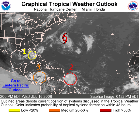
3 things to watch right now
Whats your opinion of this hurricane season so far? And what do you expect in the future?
3 things to watch right now
Number 1 has sure dumped a lot of rain on us here in Tampa Bay...lots of local flooding, but nothing too severe. Been a quiet day today though, only a
little rain.
2 and 3 definitely bear some close watching though...but will probably just bring us even more rain. We need it, somewhat, but not all at once!
[edit on 17-7-2008 by Gazrok]
2 and 3 definitely bear some close watching though...but will probably just bring us even more rain. We need it, somewhat, but not all at once!
[edit on 17-7-2008 by Gazrok]
Originally posted by LDragonFire
Whats your opinion of this hurricane season so far? And what do you expect in the future?
About average so far. Things have gotten pretty active the past couple of weeks as far as things that need to be watched, which is just about right on que.
I think this season will end up being slightly above average. Where Bertha was birthed (and where this possible developing depression in the Caribbean started), you usually don't start seeing activity there until late July-early Aug., so I'm thinking there's not much dust coming off of Africa (which really hindered Cape Verde storms - storms that develop by Africa and trek there way across the Atlantic - last year) and the water temps are pretty warm out there. That will probably push the storm totals up a bit.
Here's the updated map:
Hurricane hunters will examine #1 today and possibly #3 tomorrow.
#3 is looking much better on sat. despite it being so close to land. Winds along the beaches of GA and SC are around 20 mph, but the strongest part of the storm is over water, so yeah this will probably be a TD soon.
All 3 (Bertha, storm off U.S. coast, storm in caribbean)
www.goes.noaa.gov...
Bertha is a hurricane again. Looks like it'll threaten Iceland (as a
TS) in a couple of days. She's been a fighter and has traveled a long way.
And
Tropical Depression 3 has formed off the coast of Georgia and South Carolina. There are tropical storm watches and warnings are along the coast.
And
Tropical Depression 3 has formed off the coast of Georgia and South Carolina. There are tropical storm watches and warnings are along the coast.

CHARLESTON, South Carolina (CNN) -- Tropical Storm Cristobal moved "parallel and very close" to the North Carolina coast Sunday morning, but the storm was expected to move away from the eastern U.S. coast by Monday.
Cristobal had not strengthened beyond the 45 mph (75 km/hr) top winds measured Saturday afternoon when it reached tropical storm status, according to the 5 a.m. ET Sunday advisory from the National Hurricane Center said.
"The center of the tropical storm is expected to move parallel and very close to the coast of North Carolina today and begin to move away from the coast by Monday," the NHC said. It is expected to dump 1 or 2 inches of rain along the North Carolina coast Sunday, it said.
Cristobal moves parallel to North Carolina coast
Please visit the link provided for the complete story.
Bertha was again downgraded to a tropical storm.
The storm set several records: It is the longest-lived tropical cyclone on record during the month of July, and the third-strongest July storm on record, behind Dennis and Emily, in the 2005 hurricane season.
Please visit the link provided for the complete story.
Tropical Storm Dolly has finally formed
www.nhc.noaa.gov...
This thing has held up for about a week, but only became an organized tropical system today.
Track:
www.nhc.noaa.gov...
This thing has held up for about a week, but only became an organized tropical system today.
Track:
All eyes on Dolly now.
Forecast to be a Hurricane when it makes landfall in a couple of days. The center keeps redeveloping a bit it looks like, and it appears to be a little north of the forecast track. Meaning the center may make it across the Yucatan without actually crossing land (or just barely).
Cristobal has strengthened a bit and is now up to 50 mph. No threat to land.
MIAMI, Florida (CNN) -- Tropical Storm Dolly, expected to become a hurricane as it speeds toward Texas' coastal border with Mexico, probably will prompt a hurricane warning there Monday night, the National Hurricane Center said.
A hurricane watch already was in effect Monday afternoon from Rio San Fernando, Mexico, across the U.S.-Mexico border to Port O'Connor, Texas.
Hurricane warning expected for parts of Texas, Mexico
Please visit the link provided for the complete story.
To the members in Mexico and Texas, batten down the hatches as things could get rough.
At most, might get to Cat 1 Hurricane, so just a little wind and water damage...bet folks in New Orleans are breathing a sigh of relief, but hopefully
they're still watching it, just in case after it dies down some, it follows the coast... Even heavy rain means a bad day in New Orleans.
Brownsville seems like it's right in the path....
Brownsville seems like it's right in the path....
I'm in Corpus and my only concern is losing electricity. The heat and humidity here require us to run our A/C year round. The drainage is pretty
bad and alot of rain at one time causes flooding. Not a run for your life storm, but one we're keeping our eye on.
Fairly unlikely you'd lose power. I've been through quite a few hurricanes myself, and typically, we only lose power during a Cat 2 or higher, and
even then, it's only for a few hours. Of course, depending where you are, all it could take is maybe a fallen tree on a line, etc.
Here's the latest bulletin:
000
WTNT34 KNHC 221442
TCPAT4
BULLETIN
TROPICAL STORM DOLLY ADVISORY NUMBER 9
NWS TPC/NATIONAL HURRICANE CENTER MIAMI FL AL042008
1000 AM CDT TUE JUL 22 2008
...DOLLY NEARING HURRICANE STRENGTH...
AT 10 AM CDT...1500 UTC...THE HURRICANE WARNING FROM NORTH OF CORPUS CHRISTI TO PORT O'CONNOR HAS BEEN REPLACED WITH A TROPICAL STORM WARNING. A HURRICANE WARNING IS NOW IN EFFECT FOR THE COAST OF TEXAS FROM BROWNSVILLE TO CORPUS CHRISTI...AND FOR THE NORTHEAST COAST OF MEXICO FROM RIO SAN FERNANDO NORTHWARD TO THE BORDER BETWEEN MEXICO AND THE UNITED STATES. A HURRICANE WARNING MEANS THAT HURRICANE CONDITIONS ARE EXPECTED WITHIN THE WARNING AREA WITHIN THE NEXT 24 HOURS. PREPARATIONS TO PROTECT LIFE AND PROPERTY SHOULD BE RUSHED TO COMPLETION.
A TROPICAL STORM WARNING IS NOW IN EFFECT FROM NORTH OF CORPUS CHRISTI TO SAN LUIS PASS. A TROPICAL STORM WARNING MEANS THAT TROPICAL STORM CONDITIONS ARE EXPECTED WITHIN THE WARNING AREA WITHIN THE NEXT 24 HOURS.
A TROPICAL STORM WARNING AND A HURRICANE WATCH IS IN EFFECT FROM LA PESCA TO SOUTH OF RIO SAN FERNANDO. A HURRICANE WATCH MEANS THAT HURRICANE CONDITIONS ARE POSSIBLE WITHIN THE WATCH AREA...GENERALLY WITHIN 36 HOURS.
FOR STORM INFORMATION SPECIFIC TO YOUR AREA...INCLUDING POSSIBLE INLAND WATCHES AND WARNINGS...PLEASE MONITOR PRODUCTS ISSUED BY YOUR LOCAL WEATHER OFFICE.
AT 1000 AM CDT...1500Z...THE CENTER OF TROPICAL STORM DOLLY WAS
LOCATED NEAR LATITUDE 24.0 NORTH...LONGITUDE 94.5 WEST OR ABOUT 230 MILES...370 KM...SOUTHEAST OF BROWNSVILLE TEXAS.
DOLLY IS MOVING TOWARD THE NORTHWEST NEAR 12 MPH...19 KM/HR. A GENERAL NORTHWEST TO WEST-NORTHWEST TRACK IS EXPECTED DURING THE ENXT 24 HOURS. THIS MOTION WOULD BRING THE CORE OF DOLLY NEAR NORTHEASTERN MEXICO OR EXTREME SOUTHERN TEXAS ON WEDNESDAY.
MAXIMUM SUSTAINED WINDS HAVE INCREASED TO NEAR 70 MPH...110
KM/HR...WITH HIGHER GUSTS. DOLLY IS EXPECTED TO BECOME A HURRICANE LATER TODAY OR WEDNESDAY.
TROPICAL STORM FORCE WINDS EXTEND OUTWARD UP TO 160 MILES...260 KM FROM THE CENTER.
THE MINIMUM CENTRAL PRESSURE RECENTLY REPORTED BY A NOAA HURRICANE HUNTER PLANE WAS 991 MB...29.26 INCHES.
DOLLY IS EXPECTED TO PRODUCE TOTAL RAIN ACCUMULATIONS OF 4 TO 8 INCHES...WITH ISOLATED AMOUNTS OF 15 INCHES...OVER MUCH OF SOUTH TEXAS AND NORTHEASTERN MEXICO OVER THE NEXT FEW DAYS.
COASTAL STORM SURGE FLOODING OF 4 TO 6 FEET ABOVE NORMAL TIDE LEVELS...ALONG WITH LARGE AND DANGEROUS BATTERING WAVES...CAN BE EXPECTED NEAR AND TO THE NORTH OF WHERE THE CENTER MAKES LANDFALL.
REPEATING THE 1000 AM CDT POSITION...24.0 N...94.5 W. MOVEMENT
TOWARD...NORTHWEST NEAR 12 MPH. MAXIMUM SUSTAINED WINDS...70 MPH. MINIMUM CENTRAL PRESSURE...991 MB.
AN INTERMEDIATE ADVISORY WILL BE ISSUED BY THE NATIONAL HURRICANE CENTER AT 100 PM CDT FOLLOWED BY THE NEXT COMPLETE ADVISORY AT 400 PM CDT.
[edit on 22-7-2008 by Gazrok]
Originally posted by Gazrok
Of course, depending where you are, all it could take is maybe a fallen tree on a line, etc.
Yeah, that's usually all it takes. You could easily lose power in well less than hurricane force winds (as seen throughout the country any time a severe thunderstorm blows through)
Anyway, Dolly is now a hurricane. Cat 1 - 75mph
I sleep with a CPAP machine (for apnea). Trust me, there's nothing like waking up feeling like you're being suffocated because you've lost
electricity. Winds are expected 25 to 40 mph here. I sleep days because hubby is on 3rd shift. So I'll know before I go to bed how bad it'll be.
I may or may not sleep tomorrow depending on how things go. Have the battery operated lights out in stategic areas.
Originally posted by darkelf
I sleep with a CPAP machine (for apnea). Trust me, there's nothing like waking up feeling like you're being suffocated because you've lost electricity. Winds are expected 25 to 40 mph here. I sleep days because hubby is on 3rd shift. So I'll know before I go to bed how bad it'll be. I may or may not sleep tomorrow depending on how things go. Have the battery operated lights out in stategic areas.
Our thoughts and prayers for you and all others touched by this storm, hopefully it won't amount to much and you get to sleep like a baby.
Form one third shifter to another, may your lights remain on and your feet remain dry!
Remember your pets people!
Winds up a bit to 80 mph.
Winds in area gusting in the 30s now. Tropical storm force winds should be coming within the next couple of hours.
[edit on 22-7-2008 by ThatsJustWeird]
Winds in area gusting in the 30s now. Tropical storm force winds should be coming within the next couple of hours.

[edit on 22-7-2008 by ThatsJustWeird]
new topics
-
Late Night with the Devil - a really good unusual modern horror film.
Movies: 23 minutes ago -
Cats Used as Live Bait to Train Ferocious Pitbulls in Illegal NYC Dogfighting
Social Issues and Civil Unrest: 1 hours ago -
The Good News According to Jesus - Episode 1
Religion, Faith, And Theology: 3 hours ago -
HORRIBLE !! Russian Soldier Drinking Own Urine To Survive In Battle
World War Three: 5 hours ago -
Bobiverse
Fantasy & Science Fiction: 8 hours ago -
Florida man's trip overseas ends in shock over $143,000 T-Mobile phone bill
Social Issues and Civil Unrest: 8 hours ago -
Former Labour minister Frank Field dies aged 81
People: 10 hours ago
top topics
-
President BIDEN Vows to Make Americans Pay More Federal Taxes in 2025 - Political Suicide.
2024 Elections: 17 hours ago, 19 flags -
Florida man's trip overseas ends in shock over $143,000 T-Mobile phone bill
Social Issues and Civil Unrest: 8 hours ago, 8 flags -
SETI chief says US has no evidence for alien technology. 'And we never have'
Aliens and UFOs: 12 hours ago, 7 flags -
This is our Story
General Entertainment: 15 hours ago, 4 flags -
Former Labour minister Frank Field dies aged 81
People: 10 hours ago, 4 flags -
Cats Used as Live Bait to Train Ferocious Pitbulls in Illegal NYC Dogfighting
Social Issues and Civil Unrest: 1 hours ago, 4 flags -
Bobiverse
Fantasy & Science Fiction: 8 hours ago, 3 flags -
HORRIBLE !! Russian Soldier Drinking Own Urine To Survive In Battle
World War Three: 5 hours ago, 2 flags -
Late Night with the Devil - a really good unusual modern horror film.
Movies: 23 minutes ago, 1 flags -
The Good News According to Jesus - Episode 1
Religion, Faith, And Theology: 3 hours ago, 0 flags
active topics
-
"We're All Hamas" Heard at Columbia University Protests
Social Issues and Civil Unrest • 278 • : KrustyKrab -
Silent Moments --In Memory of Beloved Member TDDA
Short Stories • 70 • : zosimov -
-@TH3WH17ERABB17- -Q- ---TIME TO SHOW THE WORLD--- -Part- --44--
Dissecting Disinformation • 650 • : angelchemuel -
Thousands Of Young Ukrainian Men Trying To Flee The Country To Avoid Conscription And The War
Other Current Events • 135 • : twistedpuppy -
President BIDEN Vows to Make Americans Pay More Federal Taxes in 2025 - Political Suicide.
2024 Elections • 89 • : DBCowboy -
Late Night with the Devil - a really good unusual modern horror film.
Movies • 0 • : devilhunter69 -
New whistleblower Jason Sands speaks on Twitter Spaces last night.
Aliens and UFOs • 52 • : 0bserver1 -
SETI chief says US has no evidence for alien technology. 'And we never have'
Aliens and UFOs • 33 • : 0bserver1 -
Mood Music Part VI
Music • 3099 • : BrucellaOrchitis -
HORRIBLE !! Russian Soldier Drinking Own Urine To Survive In Battle
World War Three • 20 • : budzprime69