It looks like you're using an Ad Blocker.
Please white-list or disable AboveTopSecret.com in your ad-blocking tool.
Thank you.
Some features of ATS will be disabled while you continue to use an ad-blocker.

Hurricane watch 2008
page: 1share:
Well ladies and gentleman this hurricane season is said to be a active one.
National Hurricane Center
NOAA Predicts Near Normal or Above Normal Atlantic Hurricane Season
So anyone have any opinions on this season activities?
National Hurricane Center
NOAA Predicts Near Normal or Above Normal Atlantic Hurricane Season
MIAMI, Florida (CNN) -- Tropical Storm Arthur, the first named storm of the 2008 Atlantic season, formed Saturday near the coast of Belize but was already over land and was expected to weaken later in the day, the U.S. National Hurricane Center said.
But the center said the the storm could reemerge in the Gulf of Mexico and regain intensity Sunday.
Atlantic season's 1st tropical storm forms near Belize
So anyone have any opinions on this season activities?
Im skeptic to say it becuase ever since Katrina people have been Screaming "This is the year!!!"
Originally posted by UnitedSatesofFreemasons
Im skeptic to say it becuase ever since Katrina people have been Screaming "This is the year!!!"
Saying what? that a modern city will be destroyed by a hurricane?
What is your opinion of the upcoming season, do you think it will be bad meaning lots of storms lots of damage lots of deaths or not?
Since this has a nice "official" title and it is the first hurrican 2008 thread, I've topped it for Fragile Earth.
Let the hurricane watching begin.
Let the hurricane watching begin.
Good thread Dragonfire. We're currently getting some of the outflow of Aruthur........ just some T&L and much-needed rain. I feel for the folks
of Belize and Central America in general.... they can't take small storms like many other parts of the Caribbean can -- mudslide fatalities, etc.
It's looking to me like the Bermuda/Azores high is setting up currently closer to the Azores, which suggests to me a potential badness for the Eastern seaboard of the U.S. I'm no meteorologist, just a weather geek.
One thing that's wonderful is the profound myriad of tools available to weather-watchers these days. Virtually everything your local meteorologist has access to (with a few exceptions) is available online, along with professionals to assist you in interpreting them.
Here on the islands, we sometimes say that hurricanes are the lazy person's disaster, as we seem to work best under pressure, and usually start making preparations just days before the storm hits. My family -- we've been ready since LAST hurricane season.
I live in North Carolina, so every single year we are told "THIS IS THE YEAR! REALLY, SERIOUSLY, THE MOTHER LOAD IS COMING!" Every year since
Katrina they have predicted above average or way above average years..and they have been wrong. They predicted 2005 to be average and it was one of
the most active seasons ever.
I used to live on the beach - we wouldn't even evacuate until it was a Category 3 storm, sometimes a 4. Now, even half way in the state people act hysterical and stock up on food for 5 years for a 40 mile per hour tropical storm.
Now theres even a cottage industry around it - "I survived Hurricane X" tshirts and people throwing hurricane parties whenever one comes near. In my experience, those are usually the ones that die when a hurricane hits NC (hurricane parties are not wise, and very deadly). I seriously think people enjoy the excitement of a hurricane around here, its very odd.
Storm number 1 Arthur

Tropical Storm Arthur kicked up surf when it made landfall at the Belize-Mexico border Saturday and headed west with maximum sustained winds near 40 mph (65 kph), according to the National Hurricane Center in Miami, Florida.
The storm was projected to weaken as it crosses the Yucatan before moving out into the Gulf of Mexico as a tropical depression early Sunday.
There was chance it could strengthen back into a tropical storm before hitting Mexico again south of Veracruz, said Jamie Rhome, a meteorologist with the hurricane center. It was not expected to become a hurricane.
At 6 a.m. ET, the center of the storm was inland about 115 miles (185 kilometers) south-southeast of Campeche, Mexico. It was moving west at about 7 mph (11 kph). Its maximum sustained winds were near 40 miles per hour (65 kph).
The storm was expected to stay well away from the U.S. Gulf Coast.
Atlantic season's first storm moves across Yucatan
Please visit the link provided for the complete story.
So far no injuries or deaths reported w00t w00t!!
Today is the official start of the Atlantic Hurricane season.
[edit on 1-6-2008 by LDragonFire]
It's now Tropical Storm Bertha
www.nhc.noaa.gov...
Looks like it'll be a non factor to everyone except shipping...
Yahoo article:
news.yahoo.com...
www.nhc.noaa.gov...
Looks like it'll be a non factor to everyone except shipping...
Yahoo article:
news.yahoo.com...
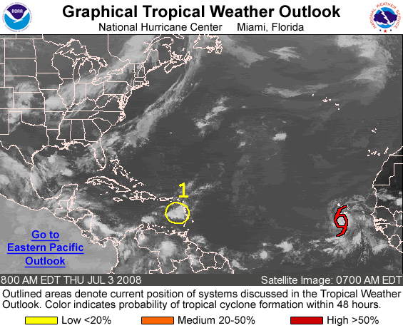
MIAMI - Tropical Storm Bertha has formed in the Atlantic Ocean off the coast of Africa.
At 11 a.m. EDT Thursday, the center of the storm was located about 190 miles south-southwest of the Cape Verde Islands.
The second named storm of the Atlantic hurricane season is moving toward the west-northwest at about 14 mph, and forecasters expect that to continue for the next couple of days.
Maximum sustained winds were near 40 mph. Some gradual strengthening is forecast during the next day or two.
......
Well that was a quick upgrade. Bertha's NHC track is significantly more south than all of the models so far though - although it would be unusual for
a storm to form that far out without curving up. There is also an 'area of interest' forming in the east Caribbean that might turn into something.
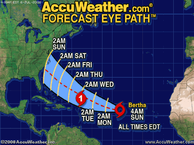
Latest track from Accuweather
Possib le U.S. landfall next weekend
And NHC
Both have shifted the track south threatening the U.S. by next weekend and both have it becoming a hurricane in a couple days.
Possib le U.S. landfall next weekend
And NHC
Both have shifted the track south threatening the U.S. by next weekend and both have it becoming a hurricane in a couple days.
Thanks for the heads up ThatsJustWeird
Looks like things might get rocky next weekend for the East coast.
Looks like things might get rocky next weekend for the East coast.
FOR THE NORTH ATLANTIC...CARIBBEAN SEA AND THE GULF OF MEXICO...
THE NATIONAL HURRICANE CENTER IS ISSUING ADVISORIES ON TROPICAL
STORM BERTHA...LOCATED ABOUT 1300 MILES EAST OF THE NORTHERN LEEWARD
ISLANDS.
ELSEWHERE...TROPICAL CYCLONE FORMATION IS NOT EXPECTED DURING THE
NEXT 48 HOURS.
NOAA
Well here we go!!
Bertha Becomes a Hurricane

MIAMI, Florida (CNN) -- Bertha became the first hurricane of the 2008 Atlantic hurricane season early Monday, according to the National Hurricane Center.
As of 5 a.m. ET, Bertha was 845 miles (1365 km) east of the northern Leeward Islands and was moving toward the west-northwest near 17 mph.
It was packing winds of 75 mph -- the minimum for hurricane status.
Additional strengthening is expected during the next couple of days, according to forecasters.
CNN
Please visit the link provided for the complete story.
Bertha Becomes a Hurricane
MIAMI, Florida (CNN) -- Bertha became the first hurricane of the 2008 Atlantic hurricane season early Monday, according to the National Hurricane Center.
As of 5 a.m. ET, Bertha was 845 miles (1365 km) east of the northern Leeward Islands and was moving toward the west-northwest near 17 mph.
It was packing winds of 75 mph -- the minimum for hurricane status.
Additional strengthening is expected during the next couple of days, according to forecasters.
CNN
Please visit the link provided for the complete story.
Winds up to 90mph now and it looks very good on satellite. Expected to be a cat 2 soon.
Good news is it's expected to curve and miss the U.S.
Well good news for the U.S., maybe not so good news for Bermuda.
Good news is it's expected to curve and miss the U.S.
Well good news for the U.S., maybe not so good news for Bermuda.
Damn that was quick...I was just looking at it this morning. Thank you for the thread and the updates....
Cait
Cait
Quick indeed.
It is now the Atlantic's first major hurricane. Winds are up to 115 making it a cat 3. I figured they would upgrade it seeing how well the eye and CDO developed this afternoon.
Latest Advisory
Latest NHC track has it missing Bermuda....to the EAST
So...this may end up being a pretty cool storm. Good looking storm to look at on sat. and doesn't pose a threat to anyone.
It is now the Atlantic's first major hurricane. Winds are up to 115 making it a cat 3. I figured they would upgrade it seeing how well the eye and CDO developed this afternoon.
Latest Advisory
Latest NHC track has it missing Bermuda....to the EAST

So...this may end up being a pretty cool storm. Good looking storm to look at on sat. and doesn't pose a threat to anyone.
More information here:
While Bertha's power may fluctuate over the next day, the storm is expected to begin gradually weakening by Wednesday, the center said.
Bertha became a major -- or Category 3 -- hurricane Monday afternoon. A Category 3 has wind speeds of 111 to 130 mph.
As predicted, the eye of the hurricane began a shift toward the northwest and slowed a bit early Tuesday, the hurricane center said at 5 a.m. ET.
CNN
Please visit the link provided for the complete story.
There now saying there is little chance of hitting the mainland USA.
Bertha weakened yesterday but is regaining some of that strength back today. Cat 1 (75 mph) last advisory but looking at the satallite and
redevlopment of it's eye and cdo, it will probably be upgraded to cat 2 or close to it next advisory.
Still doesn't look like it'll pose a threat to anyone.
Nice shot courtsey of NASA
Still doesn't look like it'll pose a threat to anyone.
Nice shot courtsey of NASA
The models are all over the place after about 48 hours or so with this storm. Some have it doing a loop. If that happens, it's possible Bermuda
(which is under a tropical storm watch now) could be brushed or affected twice .
new topics
-
In an Historic First, In N Out Burger Permanently Closes a Location
Mainstream News: 13 minutes ago -
MH370 Again....
Disaster Conspiracies: 45 minutes ago -
Are you ready for the return of Jesus Christ? Have you been cleansed by His blood?
Religion, Faith, And Theology: 3 hours ago -
Chronological time line of open source information
History: 4 hours ago -
A man of the people
Diseases and Pandemics: 5 hours ago -
Ramblings on DNA, blood, and Spirit.
Philosophy and Metaphysics: 5 hours ago -
4 plans of US elites to defeat Russia
New World Order: 7 hours ago -
Thousands Of Young Ukrainian Men Trying To Flee The Country To Avoid Conscription And The War
Other Current Events: 10 hours ago
top topics
-
Israeli Missile Strikes in Iran, Explosions in Syria + Iraq
World War Three: 14 hours ago, 17 flags -
Thousands Of Young Ukrainian Men Trying To Flee The Country To Avoid Conscription And The War
Other Current Events: 10 hours ago, 7 flags -
Iran launches Retalliation Strike 4.18.24
World War Three: 13 hours ago, 6 flags -
12 jurors selected in Trump criminal trial
US Political Madness: 13 hours ago, 4 flags -
4 plans of US elites to defeat Russia
New World Order: 7 hours ago, 4 flags -
A man of the people
Diseases and Pandemics: 5 hours ago, 3 flags -
Chronological time line of open source information
History: 4 hours ago, 2 flags -
In an Historic First, In N Out Burger Permanently Closes a Location
Mainstream News: 13 minutes ago, 2 flags -
Are you ready for the return of Jesus Christ? Have you been cleansed by His blood?
Religion, Faith, And Theology: 3 hours ago, 1 flags -
Ramblings on DNA, blood, and Spirit.
Philosophy and Metaphysics: 5 hours ago, 1 flags
active topics
-
Not Aliens but a Nazi Occult Inspired and then Science Rendered Design.
Aliens and UFOs • 15 • : anthelion -
12 jurors selected in Trump criminal trial
US Political Madness • 38 • : ImagoDei -
Thousands Of Young Ukrainian Men Trying To Flee The Country To Avoid Conscription And The War
Other Current Events • 19 • : Xtrozero -
-@TH3WH17ERABB17- -Q- ---TIME TO SHOW THE WORLD--- -Part- --44--
Dissecting Disinformation • 540 • : IndieA -
Scarface does Tiny Desk Concert
Music • 8 • : zosimov -
In an Historic First, In N Out Burger Permanently Closes a Location
Mainstream News • 0 • : underpass61 -
4 plans of US elites to defeat Russia
New World Order • 28 • : Oldcarpy2 -
Israeli Missile Strikes in Iran, Explosions in Syria + Iraq
World War Three • 72 • : DBCowboy -
Fossils in Greece Suggest Human Ancestors Evolved in Europe, Not Africa
Origins and Creationism • 67 • : strongfp -
Are you ready for the return of Jesus Christ? Have you been cleansed by His blood?
Religion, Faith, And Theology • 10 • : TruthJava