It looks like you're using an Ad Blocker.
Please white-list or disable AboveTopSecret.com in your ad-blocking tool.
Thank you.
Some features of ATS will be disabled while you continue to use an ad-blocker.

An Experiment in Alternative Methods of Earthquake Prediction
page: 191share:
Just for the record, --just in case,--
OOoo I suddenly got a real strong pressure change in my ear. Back and forth, the pressure went.
I might as well leave it there, then. Might be something.
I'm in the US MidWest, it's nearing 0730 pm Central, Teusday.
OOoo I suddenly got a real strong pressure change in my ear. Back and forth, the pressure went.
I might as well leave it there, then. Might be something.
I'm in the US MidWest, it's nearing 0730 pm Central, Teusday.
Just thought i'd add too - about 10 mins ago about 10:15AM Brisbane time, I had a massive dizzy spell, and am now lying in bed. Very drained in the
head this morning, my body feels ok, a little sore from yesterdays weights and dancing with the kidlet, but my head feels like I need more sleep.
I have a episode of muted hearing occurring. The only thing any different this time from other episodes is that the tone is steadily raising in pitch.
The sound is quiet overall, but that pitch really has my attention o.O
I'm watching GEE, Taipei to be exact, and they're experiencing a quake. If I remember the measurements criteria correctly, into the MMs is a big
quake. I'm going to take a screen shot, I'm not sure how big this one would be. Interesting that it coincided with the pitch increase
Edit: QVS alerts just popped up with a 6.1 for Taiwan. Not as big as I thought, but still a good size!
Edit 2: I said I was going to take a screen shot, and really don't think it would be nice to say I was going to post one, and then not. So here's what Taipei just had (which was also just dialed down to a 6.0 according to another QVS Alerts pop up)
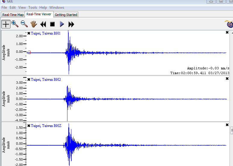
The red arrow outline indicated on the line when my muted hearing episode was, about 10 minute prior to the quake. Not entirely convinced it's anything more than a coincidence, but that's the closest time frame an episode and earthquake have been for me.
Edit: QVS alerts just popped up with a 6.1 for Taiwan. Not as big as I thought, but still a good size!
edit on 3/26/2013 by Nyiah because: (no
reason given)
Edit 2: I said I was going to take a screen shot, and really don't think it would be nice to say I was going to post one, and then not. So here's what Taipei just had (which was also just dialed down to a 6.0 according to another QVS Alerts pop up)
The red arrow outline indicated on the line when my muted hearing episode was, about 10 minute prior to the quake. Not entirely convinced it's anything more than a coincidence, but that's the closest time frame an episode and earthquake have been for me.
edit on 3/26/2013 by Nyiah
because: (no reason given)
reply to post by Nyiah
I've had the 'ringing' sound going on, inner ear.
This link here shows theres just been a 5 off of Japan (Hokkaido) and it looks a tad active just now around the world, in general.
quakes.globalincidentmap.com...
(A 6 on Tiawan.....)
(Near 3's, Alaska, real deep)
I've had the 'ringing' sound going on, inner ear.
This link here shows theres just been a 5 off of Japan (Hokkaido) and it looks a tad active just now around the world, in general.
quakes.globalincidentmap.com...
(A 6 on Tiawan.....)
(Near 3's, Alaska, real deep)
edit on 26-3-2013 by Eedjee because: added updates
Just in case it's something...
Hubby called from work less than an hour ago & said he's having a rough time of it.
All the regular eq symptoms.
I wish I would have thought to ask what level his symptoms were at!
It is awfully quiet again.
I was surprised when I looked today how few since I went to bed!
Guess time will tell!
WOQ
Hubby called from work less than an hour ago & said he's having a rough time of it.
All the regular eq symptoms.
I wish I would have thought to ask what level his symptoms were at!
It is awfully quiet again.
I was surprised when I looked today how few since I went to bed!
Guess time will tell!
WOQ
I haven't posted on this thread prior, but today my dog is being a nut job barking at everything and nothing at all. We've had her three years and
this is the nuttiest I've seen her be. Usually she barks at *something* outside (a neighbor, a squirrel, the mail delivery person), but today....
She'll jump up on a bench, look out the window and start barking and then race from window to window barking. Then she crashes because she's
exhausted and then it starts all over again. Work's been slow so I've been home most of this week and know she hasn't gotten into anything that's
making her act that way (Don't worry about my work, I'll be busy next week). We have another dog too, but he follows her lead. I'm in Central NY, a
very non-geologically interesting place to live.
I should note, we're not expecting any crazy weather here either. So she's not reacting to changing pressure systems.
I should note, we're not expecting any crazy weather here either. So she's not reacting to changing pressure systems.
edit on 28-3-2013 by
mistressofspice because: Forgot a line that might be relavent
reply to post by Observationalist
Now, that is freaky.
Here's the image you linked to of the water drainage canal in LA. I think it's good to have the actual image within this thread so readers can see and compare with what Cait wrote. (Picture credit: Manufactured Landscapes Blog. Thanks to Observationalist for first providing the link to this source.) :
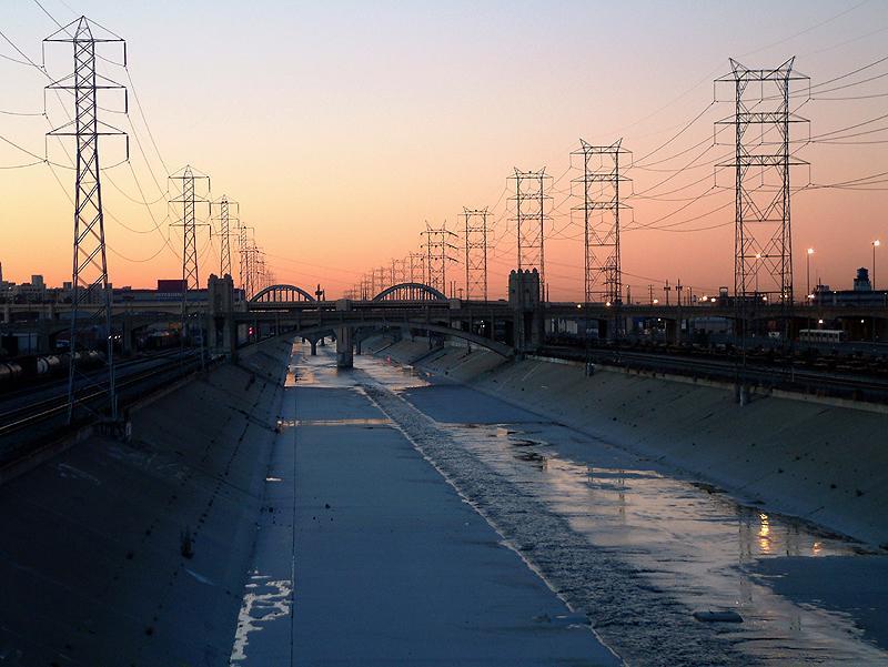
Here's Cait's post from 2/2/13 that had some of us trying to track down an image that fits:
(Bolding mine.)
That LA Canal image fits. The moment I clicked on your link I thought, “That's it! That's what Cait was talking about.” And that was before I read any further in the thread.
And in this later post on 2/2/13 Cait elaborates and provides an image & says:
(Bolding mine.)
Those tall structures that carry the power lines are correctly called “transmission towers”.
Now, that is freaky.
Here's the image you linked to of the water drainage canal in LA. I think it's good to have the actual image within this thread so readers can see and compare with what Cait wrote. (Picture credit: Manufactured Landscapes Blog. Thanks to Observationalist for first providing the link to this source.) :
Here's Cait's post from 2/2/13 that had some of us trying to track down an image that fits:
Wanted to post quickly...had a dream last night about water inundating a canal, like the water was coming in from the sea to a narrow channel, with black narrow square towers on both banks at regular intervals. The wave height looked like it was about 80-100 ft, and the water was very dark, black almost. I'm trying to find an image that matches it. I very rarely remember dreams, let alone have one so specific.
(Bolding mine.)
That LA Canal image fits. The moment I clicked on your link I thought, “That's it! That's what Cait was talking about.” And that was before I read any further in the thread.
And in this later post on 2/2/13 Cait elaborates and provides an image & says:
… What I saw was a wide flat shallow irrigation type canal, almost empty, with sloping sides. This one is in Dixon Valley, near Sacramento, and the poplar trees are about 80 ft, so my estimate of wave height was correct. I saw towers, not trees, lined up either side of a canal like this at maybe 50 ft intervals, tall and narrow like church towers. The wave came in and washed past them near the top, so I'm guessing towers about 100 ft plus high.
(Bolding mine.)
Those tall structures that carry the power lines are correctly called “transmission towers”.
edit on 28/3/13 by JustMike because: Fixed "reply to" link and added credit and link for source image.
Continuing from the above, there are only four nature-based scenarios I can imagine that could cause inundation with a wave of up to 100 ft high.
The first and perhaps most obvious is a tsunami from a major undersea megathrust earthquake, not too far from the coast. That is theoretically possible even along that stretch of California, but far more likely further north in the PNW region, where tsunamis of that height along the Cascadia Subduction Zone are known to have occurred in the past.
The second and probably much less likely along the US west coast region would be a massive storm, but the wind force (speeds and persistence) required to create such a wave are something I've never heard of.
The third but unlikely cause would be a very large volcanic eruption/explosion, possibly even thousands of miles away but within a volcano or volcanic chain that is coastal or even in an island chain. However, for such an event to send a 100-ft-high tsunami into the US west coast, it would have to be even more devastating closer to its source and there are probably no known volcanoes on the Pacific Rim capable of erupting that violently.
Just a note on this point: tsunamis from volcanic explosions (eg Thera [Santorini] and Krakatau [Krakatoa]) can be very severe, but they tend to be much more local in their effects. This is mainly because the wave length of the tsunami is much shorter than those generated by megathrust quakes and overall, the body of water moved is smaller and hence has less energy. I won't go into all the technicalities but that's the basics of it.
Short summary: a huge tsunami from a volcanic explosion is very unlikely in the US west coast region.
The fourth is one that we might not normally even consider, because it involves a combination of nature and humanity and for the most part, we've focused on inundation from tsunamis.
Up in the hills and mountains inland from LA, there are several reservoirs and as you can imagine, their capacity is huge. It has to be to supply the needs of one of the largest urban regions on the planet, especially as there is a lack of very large rivers with enough free flow to otherwise supply the needs of humans and industry year-round.
Here's what I'm thinking: perhaps the wall of water rushing down that channel doesn't come up from the sea, but comes down from a broken dam. There are many faults in the region and more that are probably not even known, simply because they haven't been active. A few hundred years of quiet means nothing with some faults.
Known fault or not, it would only take one of them to let go in a big way near a dam and it might fail and release its millions of cubic yards of water in one huge flood. In that case, it would follow the path of least resistance -- and those canals are designed the same way. Logically, a flood from a dam could wind up reaching the same piece of lower-lying land where the canals are.
The truly scary thing about this scenario is that it would not even need to be a "huge" quake. A moderately severe quake that might not do more than rattle the windows in downtown LA could be enough to destroy the integrity of a dam some dozens of miles away in the hills if the epicenter is close to the dam and it's a fairly shallow quake. And once a major dam starts to go then there's little hope of stopping it failing completely.
edit on 28/3/13 by JustMike because: Added note re volcanic explosions and their tsunamis versus megathrust quake tsunamis.
A couple of other observations.
Cait said:
In other words, if the canal is almost empty and if it's in LA or somewhere else in that general region with its Mediterranean type climate, then this event would likely happen during the drier, warmer months of the year. And that in itself can be a worry, because of this:
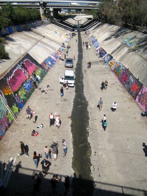
As the caption accompanying this pic on the Manufactured Landscapes Blogsite says:
The canal becomes a recreation area!
I don't think I need to go into details about what a disaster it would be if one of these huge canals was hit by a flash flood. I only hope that authorities would have time to warn people so they could all safely evacuate.
Cait said:
(Pls refer to my prior post on this page for the full quote and link.)
What I saw was a wide flat shallow irrigation type canal, almost empty, with sloping sides.
In other words, if the canal is almost empty and if it's in LA or somewhere else in that general region with its Mediterranean type climate, then this event would likely happen during the drier, warmer months of the year. And that in itself can be a worry, because of this:
As the caption accompanying this pic on the Manufactured Landscapes Blogsite says:
In the dry season when no water is flowing trough [sic] the canal it becomes a recreation area.
The canal becomes a recreation area!
I don't think I need to go into details about what a disaster it would be if one of these huge canals was hit by a flash flood. I only hope that authorities would have time to warn people so they could all safely evacuate.
edit on 28/3/13 by JustMike because: typ o
reply to post by JustMike
Thanks for putting up the image, I work from my IPad and haven't figured out how to upload images from it.
More concerns as I ponder Caitlinfae's dream and this image:
The LA Basin is one big concrete landscape, these Canals are like concrete rivers that run all throughout the populated areas of this massive city. Infact they have paved part of the Los Angeles River. A large surge of water could travel faily uninhibited as it moves up these canals, bring flood waters deep inland.
Here is a recent article talking about the Los Angeles water ways. It's mainly about restoring the surrounding habitat, but there is a similar picture to the one posted above, and a few other images along with a map to give you some perspective.
Los Angeles Reimagines Its Waterway
Obama has it as a priority too.
Edit: I posted this before your two other post
Thanks for putting up the image, I work from my IPad and haven't figured out how to upload images from it.
More concerns as I ponder Caitlinfae's dream and this image:
The LA Basin is one big concrete landscape, these Canals are like concrete rivers that run all throughout the populated areas of this massive city. Infact they have paved part of the Los Angeles River. A large surge of water could travel faily uninhibited as it moves up these canals, bring flood waters deep inland.
Here is a recent article talking about the Los Angeles water ways. It's mainly about restoring the surrounding habitat, but there is a similar picture to the one posted above, and a few other images along with a map to give you some perspective.
Los Angeles Reimagines Its Waterway
LOS ANGELES—Eighty years after the U.S. Army Corps of Engineers cast the Los Angeles River in concrete, turning this city’s original lifeblood into a storm drain, a new generation of Corps members is working to bring back at least some of its natural habitat.
Obama has it as a priority too.
The river was put on a short list of priorities for President Barack Obama’s America’s Great Outdoors initiative, and it is one of seven projects targeted under the Urban Waters Federal Partnership, a coordinated group of federal agencies taking on waterway improvements in underserved communities.
edit on 28-3-2013 by Observationalist because: (no reason given)
Edit: I posted this before your two other post
edit on 28-3-2013 by Observationalist because: Clarity
reply to post by JustMike
I agree that an upstream dam break could be most damaging, however they built these canals for flood relief.
Not sure they built them to support a dam break, and how much faster would these surging waters flow through straight cement lined channels, verses water being slowed by natural winding rivers with vegetation. Things get dicey when you start messing with natural water flows.
Found an article talking abit about this, when LA had a flood back in 1938
Link
Up in the hills and mountains inland from LA, there are several reservoirs and as you can imagine, their capacity is huge. It has to be to supply the needs of one of the largest urban regions on the planet, especially as there is a lack of very large rivers with enough free flow to otherwise supply the needs of humans and industry year-round.
I agree that an upstream dam break could be most damaging, however they built these canals for flood relief.
Not sure they built them to support a dam break, and how much faster would these surging waters flow through straight cement lined channels, verses water being slowed by natural winding rivers with vegetation. Things get dicey when you start messing with natural water flows.
Found an article talking abit about this, when LA had a flood back in 1938
Link
With the river encased in cement, the natural sharp turns were now straightened. Any evidence of vegetation was completely removed, allowing runoff from the San Gabriel Mountains to escape through the river and out of Long Beach at up to 45 miles-per-hour.
edit on 28-3-2013 by Observationalist because: (no reason given)
Good info about that project they're working on. Thanks.
Re possible dam breaks. If the San Gabriel Reservoir Dam failed completely, then somewhere around 70 million cubic yards of water could go cascading down into the Morris Reservoir just below it, and possibly overtop its dam. (San Gabriel Reservoir has a current capacity of 54,499,000 m3, which equals about 70 mil. cu yards.)
So even if the Morris Dam held -- and chances are it might for a while at least as it's concrete, unlike the San Gabriel which is a rockfill dam -- the overtopping could still allow huge amounts of water to go downstream. Even if it were only 20 or 30 percent of what was lost from the San Gabriel (say 15 - 20 mil cu yards) that would still be a devastating amount and likely way beyond the capacity of the downstream canals.
I traced the canals from the Morris down all the way and the final one reaches the sea at Seal Beach, just a little ways down the coast from Long Beach. That is assuming some of the water doesn't flood over and into other canals as well. I don't have the detailed data on the hydrological aspects to even venture a guess on that.
I haven't studied any of the other dams in any detail and have no idea if they present any threat or not to LA itself. Quite possibly, there are detailed studies for dam-failure scenarios available; I haven't checked that angle yet.
This is not a scenario I'd considered in the past for LA. Like most, I focused more on tsunami threats from the sea, along with more "conventional" scenarios for damage to in-city infrastructure and buildings. But as it's not totally far-fetched I guess it's worth having it noted here for further discussion if members wish to look into it further.
edit on 28/3/13 by JustMike because: (no reason given)
reply to post by Observationalist
Sorry, I meant to address this comment you made:
You've raised a good point. The short answer is that the water would flow much faster through a concrete-lined canal than a natural waterway, given the same width and depth of waterway and the same gradient.
In a flood situation when a canal is overwhelmed, the problem is that there is still a very strong current there which can be incredibly hazardous for any rescue craft travelling across what is otherwise just a very messily flooded area. If they hit the canal's deeper and faster-flowing current they are in serious trouble.
With the huge force in the floodwater in a pretty straight canal, anyone caught in it could be washed some distance out to sea, making their rescue even more difficult -- assuming they survive the force of the flow in the first place.
Another problem is that the concrete prevents a percentage of the water seeping into the ground through the banks, as it otherwise would in a natural waterway. So, a much larger percentage of the water will travel further than in the natural case. Ditto, less soil and natural debris will be washed in to mix with the flood water and so it is not slowed down so much by those factors either.
That's the bad side. The other side to it is that because the concrete-lined canal will tend to move a fair amount of water out very quickly, then draining away the flood will also be faster overall. Many people who might otherwise drown or at least suffer severe health problems within their own homes could possibly survive if the water recedes quickly enough, or just doesn't flood to (and maintain) such a high level because it's draining away so fast.
So, concrete canals can be a blessing and a curse. Most of the time, such as when there are very heavy rains that bring "natural" floods, they are a huge advantage. But in the event of an "un-natural" flood due to a dam failure, they can create catastrophic effects for a short period of time.
Sorry, I meant to address this comment you made:
Not sure they built them to support a dam break, and how much faster would these surging waters flow through straight cement lined channels, verses water being slowed by natural winding rivers with vegetation. Things get dicey when you start messing with natural water flows.
You've raised a good point. The short answer is that the water would flow much faster through a concrete-lined canal than a natural waterway, given the same width and depth of waterway and the same gradient.
In a flood situation when a canal is overwhelmed, the problem is that there is still a very strong current there which can be incredibly hazardous for any rescue craft travelling across what is otherwise just a very messily flooded area. If they hit the canal's deeper and faster-flowing current they are in serious trouble.
With the huge force in the floodwater in a pretty straight canal, anyone caught in it could be washed some distance out to sea, making their rescue even more difficult -- assuming they survive the force of the flow in the first place.
Another problem is that the concrete prevents a percentage of the water seeping into the ground through the banks, as it otherwise would in a natural waterway. So, a much larger percentage of the water will travel further than in the natural case. Ditto, less soil and natural debris will be washed in to mix with the flood water and so it is not slowed down so much by those factors either.
That's the bad side. The other side to it is that because the concrete-lined canal will tend to move a fair amount of water out very quickly, then draining away the flood will also be faster overall. Many people who might otherwise drown or at least suffer severe health problems within their own homes could possibly survive if the water recedes quickly enough, or just doesn't flood to (and maintain) such a high level because it's draining away so fast.
So, concrete canals can be a blessing and a curse. Most of the time, such as when there are very heavy rains that bring "natural" floods, they are a huge advantage. But in the event of an "un-natural" flood due to a dam failure, they can create catastrophic effects for a short period of time.
edit on 28/3/13 by JustMike because: typos
JustMike and Observationalist....
A very quick reply until tomorrow when I've processed this a little. I'm blown away at the effort you've both put in and how you've started to make sense of what really made no sense to me at all, apart from the clarity of delivery. I really was thinking that I was kinda getting in the way of this thread somehow, as I'm not technical at all, no science background, although I'm interested intensely, but perhaps the things I'm shown can be useful somehow.
I hadn't considered the dam break scenario...I felt that the water was coming in from the sea, in particular over the curved bridges in the distance...but when I read what you both wrote about dams upcountry breaking, it really made me shiver, not good at all.
Thank you again, and will talk more tomorrow.
Cait xx
Cait's dream was chilling enough then the images that people have been posting, wow! Mike when you mentioned the dams breaking that seems like the
more realistic scenario for the water rushing. I read Lee Goldberg's, The Walk. He does a very good job with portraying how he thinks a major
earthquake would affect this whole area.
I will go back to lurking now!
I will go back to lurking now!
I too always follow this thread and have been following all the talk in regards to Caits dream.
I can't help but wonder... and Mike.... you may know this quicker than any of us.
Is the Northern side of the coast in Cali rising and the Southern half lowering? It seems as if I can't move past this notion. I can't remember if I read it somewhere or saw a video.... or what. Am I just crazy?
Is it possible?
reply to post by caitlinfae
Hi Cait,
it sounds scary as a scenario but thankfully that's all it is at this time. Also, in spite of the eerie similarity with that image of the LA canal, what you saw could still be simply symbolic and does not have to identify that specific location.
Having said that, I'd love to know the orientation of that image. Are those curved bridges downstream -- meaning seawards from where the image was taken -- or upstream? That would be good to confirm.
reply to post by JustMike
The Wiki on the Los Angeles River gives a list of crossing bridges.
Los Angeles River Wiki
Also the canals are used for filming movies and TV shows.
Greece drag race scene
The Wiki on the Los Angeles River gives a list of crossing bridges.
Los Angeles River Wiki
Also the canals are used for filming movies and TV shows.
Numerous films and television programs have featured various sites along the Los Angeles River. Films involving the river include Terminator 2: Judgment Day, Last Action Hero, Chinatown, Them!, The Core, Grease, Point Blank, Repo Man, The Italian Job, Point Break, Gone in 60 Seconds, To Live and Die in L.A., Purple Rain, and Drive. [edit]
Greece drag race scene
reply to post by AuntB
Hi Aunt B,
good to have you creep out from your lurking!
I've never read that book you mentioned but I'll have to try and find out more about it. Thanks for the information.
reply to post by MamaJ
Hi Mama,
technically, the northernmost Californian coastal region would most likely be rising, simply because of its proximity to the Cascadia Subduction Zone, where the subducting Juan de Fuca plate and also the smaller, adjoining Gorda plate are being subducted beneath the North American plate.
These plates pushing under the Nth American plate slowly push up the edge of the coastal region there and so it's rising. But the process is incredibly slow, meaning it can take centuries to rise a few feet.
However, when there's a major "megathrust" quake and the plates suddenly release and slip, then the plate on top of the Juan de Fuca and the Gorda -- the Nth American plate -- will "spring back" as the pressure on it is suddenly eased, and when that happens, then that region of coastline may drop some feet in places.This sudden drop can happen in just minutes, and that's a problem.
This is exactly what happened in some regions along the Japanese east coast in their huge quake two years ago. Some seaside towns were sitting on land that suddenly dropped, and in at least one case I can recall, it has resulted in parts of a town being flooded by sea water every day at high tide, forcing many of the residents to abandon their homes that used to be above the high water mark. In that case, though, it was possibly a good 1,000 years since the last massive megathrust event in the same region, and so the drop in some places was several feet.
The weird thing is that some other places may wind up higher than they were before. It just depends how all the various stresses balance out, depending on what happens below the ground during the quake.
Back to the US: the effects of near-coastal land height changes will probably be more noticeable further up the coast into OR and WA (and maybe Sthn BC) than in Nth CA, however some changes there are not completely unlikely.
I'm not aware of any specific tectonic action that would be making the SoCal coast drop all that much -- certainly not quickly -- but even if there are some, there could also be other factors at work to cause subsidence in places, such as erosion.
edit on 28/3/13 by JustMike because: (no reason given)
new topics
-
Supreme Court Oral Arguments 4.25.2024 - Are PRESIDENTS IMMUNE From Later Being Prosecuted.
Above Politics: 45 minutes ago -
Krystalnacht on today's most elite Universities?
Social Issues and Civil Unrest: 54 minutes ago -
Chris Christie Wishes Death Upon Trump and Ramaswamy
Politicians & People: 1 hours ago -
University of Texas Instantly Shuts Down Anti Israel Protests
Education and Media: 3 hours ago -
Any one suspicious of fever promotions events, major investor Goldman Sachs card only.
The Gray Area: 5 hours ago -
God's Righteousness is Greater than Our Wrath
Religion, Faith, And Theology: 10 hours ago
top topics
-
VP's Secret Service agent brawls with other agents at Andrews
Mainstream News: 14 hours ago, 11 flags -
Nearly 70% Of Americans Want Talks To End War In Ukraine
Political Issues: 15 hours ago, 6 flags -
Sunak spinning the sickness figures
Other Current Events: 15 hours ago, 5 flags -
Electrical tricks for saving money
Education and Media: 13 hours ago, 4 flags -
Late Night with the Devil - a really good unusual modern horror film.
Movies: 17 hours ago, 3 flags -
Krystalnacht on today's most elite Universities?
Social Issues and Civil Unrest: 54 minutes ago, 3 flags -
Supreme Court Oral Arguments 4.25.2024 - Are PRESIDENTS IMMUNE From Later Being Prosecuted.
Above Politics: 45 minutes ago, 3 flags -
Any one suspicious of fever promotions events, major investor Goldman Sachs card only.
The Gray Area: 5 hours ago, 2 flags -
University of Texas Instantly Shuts Down Anti Israel Protests
Education and Media: 3 hours ago, 2 flags -
Chris Christie Wishes Death Upon Trump and Ramaswamy
Politicians & People: 1 hours ago, 1 flags
active topics
-
University of Texas Instantly Shuts Down Anti Israel Protests
Education and Media • 69 • : FlyersFan -
President BIDEN Vows to Make Americans Pay More Federal Taxes in 2025 - Political Suicide.
2024 Elections • 141 • : Euronymous2625 -
-@TH3WH17ERABB17- -Q- ---TIME TO SHOW THE WORLD--- -Part- --44--
Dissecting Disinformation • 664 • : 777Vader -
Nearly 70% Of Americans Want Talks To End War In Ukraine
Political Issues • 70 • : SchrodingersRat -
British TV Presenter Refuses To Use Guest's Preferred Pronouns
Education and Media • 149 • : Annee -
Hate makes for strange bedfellows
US Political Madness • 46 • : network dude -
The Reality of the Laser
Military Projects • 48 • : 5thHead -
Supreme Court Oral Arguments 4.25.2024 - Are PRESIDENTS IMMUNE From Later Being Prosecuted.
Above Politics • 1 • : network dude -
Candidate TRUMP Now Has Crazy Judge JUAN MERCHAN After Him - The Stormy Daniels Hush-Money Case.
Political Conspiracies • 744 • : Threadbarer -
Truth Social goes public, be careful not to lose your money
Mainstream News • 129 • : matafuchs