It looks like you're using an Ad Blocker.
Please white-list or disable AboveTopSecret.com in your ad-blocking tool.
Thank you.
Some features of ATS will be disabled while you continue to use an ad-blocker.

Google Earth North Pole (no ice-cap)
page: 10
share:
Hi,
please enlighten me; I swear that a while ago there was still an ice-cap over the north pole in Google Earth. What has happened; it says Arctic Ocean and it's all blue except for Greenland and some islands that have ice on them.
I feel stupid and stunned and amzed at the same time. Thanks for any reply, be gentle with me.
This might help answer your question.
The north pole is ice that floats on the surface of the sea and Google Earth shows that as blue or part of the ocean. Antarctica is actually a land mass covered in ice and is shown as is.
If you want to see the ice at the northern pole you need the sie.kml. Download it and open it with the Google Earth program.
This link should get you what you need.
www.gearthblog.com...
It's partway down the page and it's called the "Sea Ice File".
This is what I see with it installed:
Here's another link with more information for you that might be helpful:
nsidc.org...
Hope that helps....
[edit on 2/5/2008 by anxietydisorder]
The north pole is ice that floats on the surface of the sea and Google Earth shows that as blue or part of the ocean. Antarctica is actually a land mass covered in ice and is shown as is.
If you want to see the ice at the northern pole you need the sie.kml. Download it and open it with the Google Earth program.
This link should get you what you need.
www.gearthblog.com...
It's partway down the page and it's called the "Sea Ice File".
This is what I see with it installed:
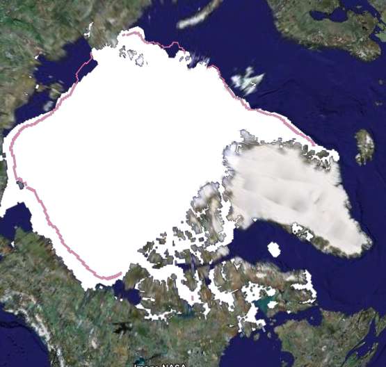
New Snow and Ice Data for Google Earth
Sea Ice Extent from NSIDC in Google EarthThe National Snow and Ice Data Center (NSIDC) is part of the University of Colorado and affiliated with NOAA. Last April the NSIDC released a Google Earth collection showing examples of glacier melting by showing the locations in GE along with photographic pairs from years ago compared to today. With the increased focus on ice and the polar regions of Earth (since the start of the International Polar Year), the NSIDC has released some new GE content. They have a page dedicated to GE content on snow and ice, and a "Featured Data" section. One of the featured content collections shows the sea ice growing and shrinking over time for both poles.
Download the Sea Ice file. You must have Google Earth installed, and you will immediately see an "animation" showing the ice extent around the poles during the month of September from 1979 through 2006.
Here's another link with more information for you that might be helpful:
nsidc.org...
Hope that helps....
[edit on 2/5/2008 by anxietydisorder]
new topics
-
Las Vegas UFO Spotting Teen Traumatized by Demon Creature in Backyard
Aliens and UFOs: 3 hours ago -
2024 Pigeon Forge Rod Run - On the Strip (Video made for you)
Automotive Discussion: 4 hours ago -
Gaza Terrorists Attack US Humanitarian Pier During Construction
Middle East Issues: 4 hours ago -
The functionality of boldening and italics is clunky and no post char limit warning?
ATS Freshman's Forum: 5 hours ago -
Meadows, Giuliani Among 11 Indicted in Arizona in Latest 2020 Election Subversion Case
Mainstream News: 6 hours ago -
Massachusetts Drag Queen Leads Young Kids in Free Palestine Chant
Social Issues and Civil Unrest: 6 hours ago -
Weinstein's conviction overturned
Mainstream News: 7 hours ago -
Supreme Court Oral Arguments 4.25.2024 - Are PRESIDENTS IMMUNE From Later Being Prosecuted.
Above Politics: 9 hours ago -
Krystalnacht on today's most elite Universities?
Social Issues and Civil Unrest: 9 hours ago -
Chris Christie Wishes Death Upon Trump and Ramaswamy
Politicians & People: 9 hours ago
0