It looks like you're using an Ad Blocker.
Please white-list or disable AboveTopSecret.com in your ad-blocking tool.
Thank you.
Some features of ATS will be disabled while you continue to use an ad-blocker.

Hi-Rise Images from Mars
page: 1/0
share:
i've gathered a couple of images from hi-rise for your perusal and opinion.....
mmm...perhaps a stop at Hellas region?
hirise.lpl.arizona.edu...
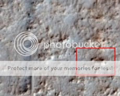
here in the Valles Marineris might be something... appears (again to be a crater except for the three things I've pointed out. What appears to square ejecta, something protruding in the upright and what seems to be its shadow........
hirise.lpl.arizona.edu...
.....hale crater region

hirise.lpl.arizona.edu...
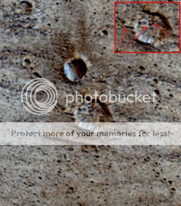
another possibility, or not.... (Hellas again) I cant tell but i'll post it anyways to see what others may think. it looks like there are some straight sides...could be decieving
hirise.lpl.arizona.edu...
thanks for looking!
spikeD.
mmm...perhaps a stop at Hellas region?
hirise.lpl.arizona.edu...
here in the Valles Marineris might be something... appears (again to be a crater except for the three things I've pointed out. What appears to square ejecta, something protruding in the upright and what seems to be its shadow........
hirise.lpl.arizona.edu...
.....hale crater region
hirise.lpl.arizona.edu...
another possibility, or not.... (Hellas again) I cant tell but i'll post it anyways to see what others may think. it looks like there are some straight sides...could be decieving
hirise.lpl.arizona.edu...
thanks for looking!
spikeD.
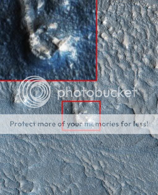
another possibilty of collapsed/eroded ruins???? in the south pole region....

hirise.lpl.arizona.edu...
hirise.lpl.arizona.edu...
I'm not seeing any high rises in the pictures, just desert, rock formations and red arrows. I think any high rise buildings would have eroded by now,
perhaps my schwanzenstook can take a better picture for you?
Interesting photos. I'll reserve judgment till some more of you image people have a look.
It's nice to know that every image that gets released is gone over by somebody I trust more than NASA.
Good work.
It's nice to know that every image that gets released is gone over by somebody I trust more than NASA.
Good work.
Bruno, all due respect... HiRise = High Resolution Imaging Space Experiment located @ the Universty of Arizona Tuscon
hirise.lpl.arizona.edu...
hirise.lpl.arizona.edu...
Thanks for posting these images!
i think these two features/formations (in the blue circles ) looks very interesting too:

Best regards, Ziggystar60.
i think these two features/formations (in the blue circles ) looks very interesting too:
Best regards, Ziggystar60.
Thank you NGC...and Ziggy (good spotting btw!) David Bowie fan I take it?
spikeD.
spikeD.
Originally posted by spikedmilk
Thank you NGC...and Ziggy (good spotting btw!) David Bowie fan I take it?
spikeD.
I know this is not topic, but yes, I am a BIG fan of David Bowie! And I am also a fan of people like you, who takes the time to share such interesting images with us here at ATS. I definetely see much more than just rocks in the images you posted!
All the best to you from Ziggystar60.
No offense, but I saw Scooby Doo in the clouds this morning on the way to work. Does this mean that scooby doo is, in fact, in the sky?
Seeing things in Mars/Moon rocks is nothing more than Pareidolia
I believe, if there was an environment that gave rise to bona fide civilization on Mars, that it is probably a "zillion" years or so in the past, at which point such structure would be eroded to the point where even mental tricks would not divulge them.
Originally posted by IgnoreTheFacts
No offense, but I saw Scooby Doo in the clouds this morning on the way to work. Does this mean that scooby doo is, in fact, in the sky?.........
Well that depends ITF, was it and advertisement for the Cartoon Network or perhaps Boom?
www.abovetopsecret.com...
No offence taken, I (we) know by now how you feel in regards to some of these subjects as you know how we feel about them. And thats fine, to each his own they say or as Bob Dylan had/has said... "You Go Your Way ,I'll go Mine"...
As long we're all friends at the end of the day and can still spill a beer or something with one another (even hypothetically)...peace.
spikeD.
SpiKe, I will say this. I have seen a few photos of Mars rocks that, to me, there is little doubt in my mind, show primitive life (fossils). Some can
be debunked very easily, others are a little harder to debunk. That is for a different thread, one in which I probably would not participate in
because my employer only pays me to come on here and post negative stuff (lol).
I think, that the truth is out there and it probably falls in between most of what is theorized here.
[edit on 9-5-2008 by IgnoreTheFacts]
I think, that the truth is out there and it probably falls in between most of what is theorized here.
[edit on 9-5-2008 by IgnoreTheFacts]
reply to post by IgnoreTheFacts
Thank you for the input ITF.
I believe it'll be just a matter of time. So long as I aint dead or blind by then.
spikeD.
Thank you for the input ITF.
I believe it'll be just a matter of time. So long as I aint dead or blind by then.
spikeD.
I've got a new image here , I am not sure what to make of it though ... I can't tell if I'm looking at an optical illusion caused by light and
shadow or I am if in fact looking at what appears to be a black orb.....


hirise.lpl.arizona.edu...
hirise.lpl.arizona.edu...

I was not aware of this thread, but now I have found it here goes.
First of all, let me say that if you are interested in the HiRISE images (I am ), you should download IAS Viewer; it allows you to see the images without having to download them all, it works more or less like Google Earth, downloading only the area that you are seeing and only to the resolution you have selected.
I think you have to register on the ITT website to download IAS Viewer, and I don't know if I am allowed to post a direct download link (which I have ).
The images seen at full resolution show much more than the browse versions you used.
It took me some time to find some of the exact spots on the images, if I am wrong just say it.
In this first photo I do not see anything unusual.
In the Valles Marineris crater, I think that the "square ejecta" are only dunes. Unfortunately, this image has some noise.
The Hale crater image is a bit strange, but it looks natural.
The straight sides on the second Hellas region photo look more natural in the higher resolution image.
The south pole image does not look like ruins, at least in this version of the image.
As this image has much noise, I decided to use the red channel version, it suffers less from the noise.
The full resolution images for the last two images that you posted show the difference it may make seeing the full resolution, lossless compressed image or just a smaller, compressed with data loss image.
I think that the crater is just an old crater, but I am not an specialist, it may not even be a crater.
First of all, let me say that if you are interested in the HiRISE images (I am ), you should download IAS Viewer; it allows you to see the images without having to download them all, it works more or less like Google Earth, downloading only the area that you are seeing and only to the resolution you have selected.
I think you have to register on the ITT website to download IAS Viewer, and I don't know if I am allowed to post a direct download link (which I have ).
The images seen at full resolution show much more than the browse versions you used.
It took me some time to find some of the exact spots on the images, if I am wrong just say it.
In this first photo I do not see anything unusual.

In the Valles Marineris crater, I think that the "square ejecta" are only dunes. Unfortunately, this image has some noise.

The Hale crater image is a bit strange, but it looks natural.

The straight sides on the second Hellas region photo look more natural in the higher resolution image.

The south pole image does not look like ruins, at least in this version of the image.

As this image has much noise, I decided to use the red channel version, it suffers less from the noise.

The full resolution images for the last two images that you posted show the difference it may make seeing the full resolution, lossless compressed image or just a smaller, compressed with data loss image.

I think that the crater is just an old crater, but I am not an specialist, it may not even be a crater.

reply to post by ArMaP
sonsofguns...........well, i can't argue the higher res pics do clarify what i thought i was seeing... i'll say it again - sonsofguns...
I do have the viewer, unfortunately this thing i have on my desk at home they deem a computer is so terribly slow, its near impossible to do anything on it like this without going all Rip Van Winkle...so I do alot of that stuff on my work cp - minus the viewer... ah well. I really wasnt counting on such a drastic loss in resolution. Thanks anyways for the pics.
spikeD.
new topics
-
In an Historic First, In N Out Burger Permanently Closes a Location
Mainstream News: 1 minutes ago -
MH370 Again....
Disaster Conspiracies: 33 minutes ago -
Are you ready for the return of Jesus Christ? Have you been cleansed by His blood?
Religion, Faith, And Theology: 2 hours ago -
Chronological time line of open source information
History: 4 hours ago -
A man of the people
Diseases and Pandemics: 5 hours ago -
Ramblings on DNA, blood, and Spirit.
Philosophy and Metaphysics: 5 hours ago -
4 plans of US elites to defeat Russia
New World Order: 7 hours ago -
Thousands Of Young Ukrainian Men Trying To Flee The Country To Avoid Conscription And The War
Other Current Events: 10 hours ago
top topics
-
Israeli Missile Strikes in Iran, Explosions in Syria + Iraq
World War Three: 14 hours ago, 17 flags -
Thousands Of Young Ukrainian Men Trying To Flee The Country To Avoid Conscription And The War
Other Current Events: 10 hours ago, 7 flags -
Iran launches Retalliation Strike 4.18.24
World War Three: 13 hours ago, 6 flags -
12 jurors selected in Trump criminal trial
US Political Madness: 13 hours ago, 4 flags -
4 plans of US elites to defeat Russia
New World Order: 7 hours ago, 4 flags -
A man of the people
Diseases and Pandemics: 5 hours ago, 3 flags -
Chronological time line of open source information
History: 4 hours ago, 2 flags -
Are you ready for the return of Jesus Christ? Have you been cleansed by His blood?
Religion, Faith, And Theology: 2 hours ago, 1 flags -
Ramblings on DNA, blood, and Spirit.
Philosophy and Metaphysics: 5 hours ago, 1 flags -
MH370 Again....
Disaster Conspiracies: 33 minutes ago, 0 flags
active topics
-
In an Historic First, In N Out Burger Permanently Closes a Location
Mainstream News • 0 • : underpass61 -
Thousands Of Young Ukrainian Men Trying To Flee The Country To Avoid Conscription And The War
Other Current Events • 17 • : Vermilion -
4 plans of US elites to defeat Russia
New World Order • 28 • : Oldcarpy2 -
Israeli Missile Strikes in Iran, Explosions in Syria + Iraq
World War Three • 72 • : DBCowboy -
Fossils in Greece Suggest Human Ancestors Evolved in Europe, Not Africa
Origins and Creationism • 67 • : strongfp -
Are you ready for the return of Jesus Christ? Have you been cleansed by His blood?
Religion, Faith, And Theology • 10 • : TruthJava -
Not Aliens but a Nazi Occult Inspired and then Science Rendered Design.
Aliens and UFOs • 13 • : Ophiuchus1 -
12 jurors selected in Trump criminal trial
US Political Madness • 36 • : Cvastar -
MH370 Again....
Disaster Conspiracies • 0 • : Cvastar -
So I saw about 30 UFOs in formation last night.
Aliens and UFOs • 34 • : Arbitrageur
0