It looks like you're using an Ad Blocker.
Please white-list or disable AboveTopSecret.com in your ad-blocking tool.
Thank you.
Some features of ATS will be disabled while you continue to use an ad-blocker.

strange chinese aircraft area
page: 12
share:
Dont know if this has been put up before as im new on here, but here it is on google earth
40 27' 31.81" n 93 18' 47.50" e
Does anyone know what this is
also if you look to the right there is a box shape with lots of roads within it and evan farther right is a simulated airbase?????
[edit on 30-4-2008 by immortal pagan]
40 27' 31.81" n 93 18' 47.50" e
Does anyone know what this is
also if you look to the right there is a box shape with lots of roads within it and evan farther right is a simulated airbase?????
[edit on 30-4-2008 by immortal pagan]
hmm very strange
theres also this about 4.3 miles away to the right
40°27'23.29"N 93°23'37.55"E
theres also this about 4.3 miles away to the right
40°27'23.29"N 93°23'37.55"E
Very interesting indeed. That's a good find, how did you happen upon it?
And wow! The coords from the above post.. What the heck is that?!
Here's a strange grouping of buildings not far from those sites:
40.491030, 93.511108
This is interesting as well:
40.454360, 93.742776
[edit on 4/30/2008 by Eshyn]
And wow! The coords from the above post.. What the heck is that?!
Here's a strange grouping of buildings not far from those sites:
40.491030, 93.511108
This is interesting as well:
40.454360, 93.742776
[edit on 4/30/2008 by Eshyn]
re.Eshyn
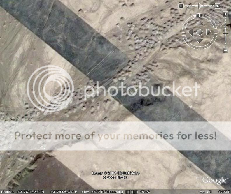
Yes i mentioned the runways and if you zoom in on the blue one at the end it looks like its taken some heavy bombing so maybe its a test site for fighters or somthing?
I came across the site while looking for aintcent sites
Also at 40°27'31.96"N 93°17'36.48"E there are 2 buildings that look out of place?
Hi Guys,
The runways are part of the target range, very similar to the TTR.
Cheers
Robbie
The runways are part of the target range, very similar to the TTR.
Cheers
Robbie
Also check out
40 28 39.57n 93 30 37.93e
40 27 12.26n 93 44 35.88e
40 28 39.57n 93 30 37.93e
40 27 12.26n 93 44 35.88e
Those are some really weird things.
Did you notice just to the west of the big box with roads the levelled area to the west? It is 800m on a side and it has been dug in and raised up to form a seeming totally flat square.
Did you notice just to the west of the big box with roads the levelled area to the west? It is 800m on a side and it has been dug in and raised up to form a seeming totally flat square.
here is something interesting too 38°15'58.07"N 105°57'11.08"E
Lots of neat stuff! Flagged and starred!
I think this might be China's answer to Area-51. Notice the dry lake bed off to the North west. But no runways, as with our beloved Groom Lake. However, a few miles NorthEast, we see not one but TWO runways, non linked. Although at different angles, the runways seem to parallel each other. Same runway size, basic configuration. Looks liek their made of different tarmac though. Maybe the one to the East is newer. Wild.
Just barely South of the "newer" runway theres one runway out in the middle of nowhere. I'm no pilot but it looks pretty odd. I'm also no Map Surveyor, but it looks like this whole base is o the side of a mountain? I see a 200' declination going south, probably at least over 10 miles. If its true, I[m not sure what to think. I dont think its effective to have a target, much less a runway set up on the side of a mountain.
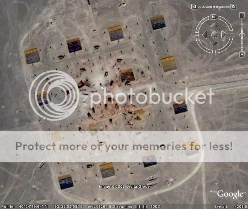
The aircraft are Mig-19 Farmer, or possibly Mig 17s, most likely Chinese built Shenyangs. Basically old junkers, so I would guess they're basically for target practice. I would guess its for Radius effect, considering how everythings set up. Its just a guess.
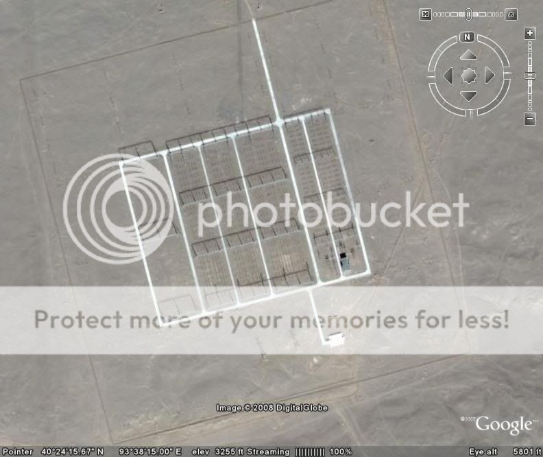
Whoever posted those blue close knot buildings off to the east, those are probably barracks. Again, just a guess. Only reason I can see for having close knit houses. Must be cold in the winter, much less if its in the mountains.
It all looks abandoned for the most part, but thats a guess.
Good find, regardless!
I think this might be China's answer to Area-51. Notice the dry lake bed off to the North west. But no runways, as with our beloved Groom Lake. However, a few miles NorthEast, we see not one but TWO runways, non linked. Although at different angles, the runways seem to parallel each other. Same runway size, basic configuration. Looks liek their made of different tarmac though. Maybe the one to the East is newer. Wild.
Just barely South of the "newer" runway theres one runway out in the middle of nowhere. I'm no pilot but it looks pretty odd. I'm also no Map Surveyor, but it looks like this whole base is o the side of a mountain? I see a 200' declination going south, probably at least over 10 miles. If its true, I[m not sure what to think. I dont think its effective to have a target, much less a runway set up on the side of a mountain.
The aircraft are Mig-19 Farmer, or possibly Mig 17s, most likely Chinese built Shenyangs. Basically old junkers, so I would guess they're basically for target practice. I would guess its for Radius effect, considering how everythings set up. Its just a guess.
Whoever posted those blue close knot buildings off to the east, those are probably barracks. Again, just a guess. Only reason I can see for having close knit houses. Must be cold in the winter, much less if its in the mountains.
It all looks abandoned for the most part, but thats a guess.
Good find, regardless!
I like what "kthulu" had to say about the Area 51 thing and the blast radius. Very probable.
I would have to agree with the concept of a site for measuring blast radius. It looks like upright sections of rings designed to blow over with the
blast at the centre.
I also agree it appears to be halway up a mountain. The snowcap peaks are pretty obvious to the north and the river which would indicate the low point of the valley is well to the south. It does seem an odd place for a test range and airstrip.
Speaking of airstrips, take a closer look at the older looking one. On closer inspection it appears to be a combination of strips cut from at least two other photos of the area and the topography has benn matched up across all three source pics. Strangely, there appears to be some dirt mounds piled up all over the places which seem out of place on the older photo strips. It's not actually a runway, it's photos cut out in the shape of a runway
A closeup pic of it might help explain
These mounds are also starting to appear on the newer runway, they appear to be landfilling a section across the bottom. It makes you wonder why so much dirt was dumped down near the old runway and surrounds though...an awful lot mounds there...
I had a bit more of look around this morning and found what looks like an older test site, it's definitely been used.
Then I followed some of the roads around from there. One ends in the middle of nowhere to the southwest. Another took me to what looks like a base of some sort to the southeast. It's odd becuse what makes it stand out is that same shade of white used on the newer one of the runways mentioned earlier. If not for that on the 'roads' (they appear to go over the buildings) it would be much harder to pick up...
Enough for now
Originally posted by immortal pagan
here is something interesting too 38°15'58.07"N 105°57'11.08"E
Another interesting find. That landscape looks almost....Martian, except for the lakes of course.
Congatulaions mate, the very first star I have ever given out is yours
[edit on 2-5-2008 by troppo_ozstyle]
Originally posted by immortal pagan
Dont know if this has been put up before as im new on here, but here it is on google earth
40 27' 31.81" n 93 18' 47.50" e
Does anyone know what this is
also if you look to the right there is a box shape with lots of roads within it and evan farther right is a simulated airbase?????
[edit on 30-4-2008 by immortal pagan]
hey, i just looked at that site, and a bit to the right i found this VERY STRANGE..
ehm.. picture? it looks like some geometry or something, i dont know.
imageshack.dk.../imagesfree/bce29815.jpg
imageshack.dk.../imagesfree/jm429838.jpg
imageshack.dk.../imagesfree/uZ729858.jpg
???
EDIT: its the same damn thing you described in your post, lol. but its strange.
[edit on 3-5-2008 by makkerskilap]
this whole orange area is VERY strange.
omg.. its amazing really. tests sites, strange geometrical figures,
weird building, bases, i just zoomed in on what i THOUGHT was a lake, and there was something looking like helicopters or the drones? i have no idea.
imageshack.dk.../imagesfree/zyS31107.jpg
do you?
omg.. its amazing really. tests sites, strange geometrical figures,
weird building, bases, i just zoomed in on what i THOUGHT was a lake, and there was something looking like helicopters or the drones? i have no idea.
imageshack.dk.../imagesfree/zyS31107.jpg
do you?
Hi all, Iv been away for the weekend so have only just read the replies put up on this thread and I am glad to see others are interested in the area I
have found. Anyways Iv been looking around China on google earth and have found that the runways on air bases are of a similar design to each other
but the ones pointed out in this thread are different and nothing like any i have found in China.
these are some i have found:-
Fuxin airbase
Shenyang yu hung tun airbase
Shenyang beiling aribase (Shenyang Aircraft corporation where the Stealth J-XX is being built)
Chaoyang airbase
Niu-chia-ying-tzu airbase
And an unidentified Airbase close to Pingquan
My question is this: The runways mentioned at the start of this thread must be mock ups of other runways? maybe from another country?
It would be interesting to have your thoughts on this???
[edit on 6-5-2008 by immortal pagan]
Originally posted by immortal pagan
here is something interesting too 38°15'58.07"N 105°57'11.08"E
from Wikipedia:
Google Earth Speculation
In June 2006, satellite imagery on the Google Earth service revealed a 500:1 scale terrain model of eastern Aksai Chin and adjacent Tibet, built near the town of Huangyangtan, about 35 kilometres South West of Yinchuan, the capital of the autonomous region of Ningxia in China. A visual side-by-side comparison shows a very detailed duplication of Aksai Chin in the camp. The 900m × 700m model was surrounded by substantial facility, with rows of red-roofed buildings, scores of olive-colored trucks and a large compound with elevated lookout posts and a large communications tower. Since terrain models are known to be used in military training and simulation (although usually on a much smaller scale), posters in the Google Earth online community advanced theories regarding the purpose of the model, including usage as
- a model for walk-through terrain visualization exercise in pilot training
- a navigation/gunnery training area for unmanned aerial vehicles that drop small flour or paint bombs in an exercise to simulate trajectories and dispersal patterns
- a model to study dispersal patterns of chemical or biological weapons
- a tank training facility.
- a model simulating water catchment areas of China's major river systems in climatology research.
Local authorities in Ningxia, however, maintain that the model is part of a tank training ground, built in 1998 or 1999.
new topics
-
Is the origin for the Eye of Horus the pineal gland?
General Conspiracies: 29 minutes ago -
Man sets himself on fire outside Donald Trump trial
Mainstream News: 40 minutes ago -
Biden says little kids flip him the bird all the time.
2024 Elections: 46 minutes ago -
The Democrats Take Control the House - Look what happened while you were sleeping
US Political Madness: 1 hours ago -
Sheetz facing racial discrimination lawsuit for considering criminal history in hiring
Social Issues and Civil Unrest: 1 hours ago -
In an Historic First, In N Out Burger Permanently Closes a Location
Mainstream News: 3 hours ago -
MH370 Again....
Disaster Conspiracies: 3 hours ago -
Are you ready for the return of Jesus Christ? Have you been cleansed by His blood?
Religion, Faith, And Theology: 6 hours ago -
Chronological time line of open source information
History: 7 hours ago -
A man of the people
Diseases and Pandemics: 8 hours ago
top topics
-
Israeli Missile Strikes in Iran, Explosions in Syria + Iraq
World War Three: 17 hours ago, 18 flags -
In an Historic First, In N Out Burger Permanently Closes a Location
Mainstream News: 3 hours ago, 14 flags -
Thousands Of Young Ukrainian Men Trying To Flee The Country To Avoid Conscription And The War
Other Current Events: 14 hours ago, 7 flags -
The Democrats Take Control the House - Look what happened while you were sleeping
US Political Madness: 1 hours ago, 7 flags -
Iran launches Retalliation Strike 4.18.24
World War Three: 16 hours ago, 6 flags -
12 jurors selected in Trump criminal trial
US Political Madness: 16 hours ago, 4 flags -
4 plans of US elites to defeat Russia
New World Order: 10 hours ago, 4 flags -
A man of the people
Diseases and Pandemics: 8 hours ago, 4 flags -
Biden says little kids flip him the bird all the time.
2024 Elections: 46 minutes ago, 3 flags -
Sheetz facing racial discrimination lawsuit for considering criminal history in hiring
Social Issues and Civil Unrest: 1 hours ago, 2 flags
active topics
-
Israeli Missile Strikes in Iran, Explosions in Syria + Iraq
World War Three • 99 • : Oldcarpy2 -
The Democrats Take Control the House - Look what happened while you were sleeping
US Political Madness • 14 • : xuenchen -
President BIDEN Warned IRAN Not to Attack ISRAEL - Iran Responded with a Military Attack on Israel.
World War Three • 46 • : ImagoDei -
Man sets himself on fire outside Donald Trump trial
Mainstream News • 7 • : OnlyYouKnow2 -
12 jurors selected in Trump criminal trial
US Political Madness • 70 • : xuenchen -
Biden says little kids flip him the bird all the time.
2024 Elections • 4 • : marg6043 -
Thousands Of Young Ukrainian Men Trying To Flee The Country To Avoid Conscription And The War
Other Current Events • 24 • : DerBeobachter2 -
"We're All Hamas" Heard at Columbia University Protests
Social Issues and Civil Unrest • 131 • : marg6043 -
So I saw about 30 UFOs in formation last night.
Aliens and UFOs • 35 • : charlyv -
Sheetz facing racial discrimination lawsuit for considering criminal history in hiring
Social Issues and Civil Unrest • 5 • : Shoshanna
2