It looks like you're using an Ad Blocker.
Please white-list or disable AboveTopSecret.com in your ad-blocking tool.
Thank you.
Some features of ATS will be disabled while you continue to use an ad-blocker.

Russia 'shot down Georgia drone'
page: 2share:
Originally posted by Britguy
Interesting that the recovered wreckage is covered in stencils in English, not the native language of the area or, most likely, it's military.
Ummm since English is the only language to be use in aviation for clarity and safety sake it makes sense that the aircraft would be labeled with said language on the exterior of the plane.
Originally posted by HatTrick
Meanwhile, hundreds of Allied pilots are crapping their g-suits as they realize that Russian pilots can, and will, effectively shoot your Rolex-wearing butts DOWN.
Haha I can't believe that you so clueless as to put a dumb UAV that was almost certainly intentionally flown into a bad situation on par with a Pilot with 5-7 years of training at least that is armed and whose job is too shoot down another aircraft.
Seriously that is pointless banter geared towards miss leading this thread and very transparent to anyone who knows anything about air combat.
Originally posted by Absence of Self
However if you check the video at 25 seconds you can see that the one in question does not have the radar pod attached so the fact that it knew that a Mig 29 was approaching to a suspiciously short range at a suspiciously low velocity using a really weird attack vector and deploying rather inappropriate ordinance for the job is something of a mystery.
The fact of the missing radar is interesting since it seems that you wouldn't want to lose that equipment to a "suicide run". There is plenty of other ways of tracking the incoming MIG through ground based radar etc. But the fact is that its still a huge cost lost to have the UAV shot down so is it a calculated move of some sort?
Its a small amount of coast that the UAV could of been out over and you can see the coast in the youtube video.
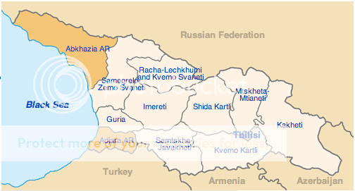
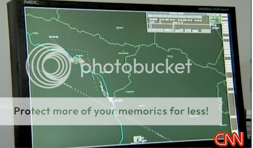
If you look at the CNN screen capture of the air force display they claim the 29 was in Abkhazia which they the Georgians claim is "illegal" (I wouldn't know). The Abkhazia "state" "nation" has said that they would shoot down Georgian planes and it seems they have asked the Russians to help. Also the capture shows how muddled and close the UAV seemed to have been the Abkhazia airspace so its impossible to tell with the info we have if they where or weren't overhead but you can be sure to be that close you could understand why the Abkhazia officals would think they where being spied on.
[edit on 22-4-2008 by Canada_EH]
www.cnn.com...
it would seem that the UAV was operating over Abkhazian airspace and was shot down by a Russian MiG-29 , based in the town of Gudauta in support of the local government.
apparantly Georgia bought 2, Elbit Hermes 450 from Israel this year - but both have now been shot down , the first on march 18th with parts pulled from the black sea and this one today;
it does begger the question - if this is the second shoot down , why only mention this one
oh wait they got a video of russia doing it
[edit on 22/4/08 by Harlequin]
reply to post by Britguy
Well Gorgia is a member of the Euro Union & the UN. Stands to reason they would be buying British/US Hardware.
The US is setting up their First Defence Shield across the region also.
I can't blame the Russians for being a little edgy.
I wouldn't want a forign power to use my own backyard against me, so that if I do fire off a few nukes, they would be shot down over my own territory, before they have cleared the ground..lol
Originally posted by Ironclad
Well Gorgia is a member of the Euro Union & the UN.
Not true. They are not a member of the EU.
Wiki
Georgia is currently a member of the United Nations, the Council of Europe, the Commonwealth of Independent States, the World Trade Organization and the Organization of the Black Sea Economic Cooperation, and seeks integration with the European Union and NATO.
The missile fired could very well have been a R-60 Aphid, the R-60 is used to bridge the gap
between missile and gun range, likely the pilot in question decided the R-60 would provide the cleanest kill.
it was a more stand-off range so it was safer and there was no risk of a collision with the other aircraft or debris that would come off from firing the GSh-30-1 30mm cannon on the target.
The target was definitly at
it was a more stand-off range so it was safer and there was no risk of a collision with the other aircraft or debris that would come off from firing the GSh-30-1 30mm cannon on the target.
The target was definitly at
I wonder how long the UAV was in flight before it was shot down, I mean, was it shot down as soon as it became visible to Russian radar...
I don't know, maybe there is something in that area especially important and/or sensitive that the Russians wish to remain concealed...
I think, most likely, just a show of a willingness to use force, intended to be received by the U.S. and her allies in the region.
I don't know, maybe there is something in that area especially important and/or sensitive that the Russians wish to remain concealed...
I think, most likely, just a show of a willingness to use force, intended to be received by the U.S. and her allies in the region.
Abhazia may become an " independent " state under the Russian protection .
I should feel happy , but somewhat I ain't feeling joyfull .
youtube.com...
I should feel happy , but somewhat I ain't feeling joyfull .
youtube.com...
No politics, just few observations: This is about the recent
video, say
www.youtube.com...
or anywhere else (BBC seems to have a better quality video,
but it is harder to access.
It appears that the images of the coastline are genuine, and
you can match the actual area to that on Google Earth. Just
play with it a little bit.
To identify the place:
----------------------
Install GoogleEarth, and then look at the east coast of
Black see and find place called "Ochamchira". Note that the
quality of the image on Googearth is not very good specifically
in this place and the area of interest is in a brown rectangle,
which is darger and than the surrounding rectangles, which
are mostly green. Once you find "Ochamchira" on google Earth
go a little bit south along the coast, until you see a small
town called "Meore Gudava" it is labelled on Google Earth
maps. This place is characterized by an identation on the
coast line, and a river which goes almost perpendicular
to the coast, them makes 90-degree left turn and enters to
the Sea.
Stop the video at the moment when you can see wheel
of the UAV in the upper-left corner of the screen no more
than 1/6 of the wheel must be visible: if more roll the
movie back a little bit. At this moment on the right
portion of the screen you shoold see and recognize
the river making 90-degree right turn, the identation
of the coast, and the city of "Meore Gudava".
Now back to Google Earth south from Meore Gudava observe
a narrow triangular strip of land free of vegetation, which
looks lighter than the surrounding (the sharp edge of the
triangle points south). Also you will see a dark spot a bit
further south along the coast.
Roll back movie, so that you about 2 seconds before the
wheel appears: you should recognize the spot and the
triangle.
Based on what I see in the movie, the UAV is off-shore,
a bit south from the black spot. I would place the UAV at
42 deg 30' North
41 deg 30' East
Given that the difference in north-south direction between
Meore Gudava and the black spot is 5', or 5 nautical miles,
or 9 kilometers, cooordinate, and given the ~60 angle of
the coast relatively to the screen, and the way how view
moves, I would estimate the distance to the coast from the
UAV at about 6 km, and altitude of the UAV about the same,
6km.
[ Yes, in is well inside Abhaz territorial waters, for
those who cares ]
The video of the coastline in genuine.
[ If you assume that this video is correct, the UAV was
shot down would fall into the Sea: there is simply no
other way. This is consistent with Abkhaz claim of the
plane shot down on March 18 (it fell into the Sea and
they could not recover pieces; Georgia denied then and
still denies today that that incident ever took place).
It is NOT CONSISTENT with last Sunday, April 20 shutdown:
this time the UAV was shot down over land, and Abkhaz's
quickly recovered the wreckage and show it on TV.
I personally believe that both events took place, and
therefore TWO Georgian UAVs were shot down in two month.
There are also unconfirmed claims by Abkhazs about shoting
down another UAV last year, deep over land, when they
could not recover wreckage because of mountains.
Russia maintains that the UAVs were wrightfully shot
down, but yields all credits to Abkhazs. Abkkazs
insists that they did it. Georgia admits only one of
the two confirmed cases, and gives the glory to
Russians.
Personally I would love to have one of the Russian
generals saying "Yes, we did it, and it is correct,
and every mf...ker flying there will be downed in a
manner shown in the movie". But this is not what they
say: in fact, they say nothing. ]
However, the image of Mig-29 firing missile has a problem:
----------------------------------------------------------
As a matter of fact, in reality Mig-29s do not have missile
rails right on the wingtips, and the missile closest to the
wing tip of the wing is about 1/3 of the wingspan inside,
see, for example
www.fas.org...
Apparently, Mig-29 never had wing tip rails (no modification of
the plane ever) and it cannot have it because its wing tips are
slightly rounded (like F15), which structurally excludes
installing the missile rails at the tips.
Now, if you stop the the Georgian video at the right moment,
just when missile detaches from the wing, you will see that
the missile originates right at the wing tip. Just do clicking,
but be patient and try to do it several times. Also observe
the shine of sunlight on the left wing just before the missile
is fired to have a good idea about where the left wing ends.
Note that missile engine starts before the missile leaves
the plane, to that on this video I was able to do a double
click with my mouse observing the smog, while the missile
is still attached to the plane. (I kwow that some newer
planes like F-22 eject the missile downward, before its
engine starts -- if the missile is carried inside the
fuselage, there is simply no other way)
If it is not the 29, so what it is?
Of the russian planes only two types: Mig-25/31 (looks
like... may be(?)) and Su-27 (incl. all its derivatives)
has rails at the wing tips.
However Mig-25/31 are excluded because they look very
differently.
Su-27 is closer to Mig-29 in appearance, but its twin
tails are straight vertica and parallel to each other
(like the ones of F-15, and not bent outward, like on
the 29, or on F-18). Also 27 has a longer front portion
of the fuselage before its forward wing extentions begin,
and distinct tailboom going beyond the rear end of the
engines. See
www.airforce-technology.com...
The two types, Mig-29 and Su-27, routinely fly together
on airshows in close formation, so it is pretty easy to
compare how they look like from various directions for
example,
video.aol.com...
The plane on Georgian video is definitely looks more
like the 29 than the 27 ... but with wing tip missile
rails like Su-27. This is a common kind of sloppyness
for Universal Studios, Hollywood -- you can find a lot
of oopses like that in Hollywood movies -- but it is
an unforgivable for Georgian airforce colonel, who
should know how Mig-25 looks like.
Any comment?
The aircraft in the vid is definately a MiG-29. The MiG-29 has completed some tight turns to get into position. Its leading edge slats will be
deployed and from that camera angle the wing tip is not clearly visible.
The missile that you see will be coming from the inboard wing pylon nearest the tip. The deployment of the slats at that distance will make it appear as if the missile has come off the wing-tip. The aircraft is not a Flanker of any variant and definately not a MiG-25.
The missile that you see will be coming from the inboard wing pylon nearest the tip. The deployment of the slats at that distance will make it appear as if the missile has come off the wing-tip. The aircraft is not a Flanker of any variant and definately not a MiG-25.
reply to post by Harlequin
So you are saying that what I see on the video is not
the reflection of sunlight from the top surface of the
main surface of the wing (which is seen at very shallow
angle from the UAV) but the sunlight reflected from the
top surface of the leading-edge slats, which are deployed
at this moment (bent downward), end therefore at a more
favorable angle to reflect sunlight toward UAV.
And, because Mig-29 slats to not extend all the way to
the very end of the wings, by judging the end of the wing
by the extent of sunlight reflection (which is dominated
by the reflection from the slat) I misjudge its length:
the wing is actually longer than it looks like. This leads
the the illusion than the missile is coming from the wing
tip, when in fact it is not.
Lets check it out:
Here is Mig-29 close and personal, preparing to take off
with its leading edge slats deployed:
www.sci.fi...
or
www.sci.fi...
The slats are, indeed, do not go all the way to the
wing tip, and terminate half way between the outer
missile rail and the wing tip. That would place the
missile a bit closer to the extent of reflected light,
but not all the way.
...Plausible explanation, but not conclusive.
More importantly:
The time when all this unfolding is 9:53am according
to the UAV clock. This is in the morning, and Sun is
about ~30 degrees above the horizon, on the south-east
(I would place it at 5 o'clock, if 12 is north, so
the sunlight is coming from the coast, and about
30 degrees to the coast line. Just use GoogleEarth
to see orientation of the scene). The attacking plane
s heading to south-west, about to ~8 o'clock at the
time when missile is fired. So it is illuminated by
the sunlight from the right as seen from UAV.
[ From the point of view of Mig pilot, the Sun is 45
or more toward 90 degrees on the left at the time
when missile is fired, but there is ABSOLUTELY NO
WAY he is facing Sun directly in front of him at
this moment.
...besides, he would be blinded by
the Sun and will not be able to see the UAV: remember,
he is coming from below when he attacks.
...perhaps, it is the orientation of
the Sun relatively to UAV, which leads to this violent
high-g turn before the attack: assuming that he is
flying from Gudauta along the coast heading southward,
he faces the Sun in front of him, still slightly on
his left. So he goes in-shore, and then turns to the
right.
...I see no other explanation for the
high-g maneuver when attacking a slow flying (basically
stationary target). Or perhaps he saw Tom Cruise
Top Gun movie and drunk too much beer with his friends
the night before. So he got excited about it, of feels
Yahoo, so something. ...after all he is Russia. ]
Under these light conditions, because the Mig-29 wing
leading edge is swept about 35 degrees, the slat on the
left wing of Mig-29 (the side from which the missile is
fired) should reflect MUCH MORE LIGHT UAV than the slat
on the opposite wing.
[ Note the difference in visual brightnesses of the left
and right slats on the photograph
www.sci.fi...
where the light is coming more from the right (left
side of the plane)]
As seen on the Georgian video, the brightness of the
light reflected by the left and right sides of the wing
is pretty much the same just before the missile was
fired. This indicates that the light is reflected by
the top of the main surface of the wing, which is more
or less flat, and most likely the slats are not deployed
on this moment.
Any comment?
Does anybody on this forum can help to get an MPEG file
of the video?
BBC has the best quality and allows to see it, but you
cannot download it from them. Videos on Youtube are
mostly of depleted quality.
Another Georgian drone was seen over Abkhazia (this is not 'the' Russia [Russian Federation]
most of you think of) last Monday (on the 5th). Abkhasian forces showed the remains of two shot down drones from the previous day (4th of
May).
That makes 7 shot-down drones from March 2008. And countless others which keep coming in and out. Georgia denies everything.
The drones are Israeli Hermes-450 unmanned spyplanes.
Hermex 450
Before jumping to any conclusions, for those who lack the knowledge of what's really going on there, please take a look at why this is happening:
Georgian-Abkhazian Conflict
And for those of you who don't know where Georgia is: Georgia
Back to the topic...
Short Video from the news on TV
Another Short Video
Some photos from Vesti.Ru:


new topics
-
Who guards the guards
US Political Madness: 2 hours ago -
Has Tesla manipulated data logs to cover up auto pilot crash?
Automotive Discussion: 4 hours ago -
whistleblower Captain Bill Uhouse on the Kingman UFO recovery
Aliens and UFOs: 9 hours ago -
1980s Arcade
General Chit Chat: 11 hours ago
top topics
-
Lawsuit Seeks to ‘Ban the Jab’ in Florida
Diseases and Pandemics: 16 hours ago, 20 flags -
whistleblower Captain Bill Uhouse on the Kingman UFO recovery
Aliens and UFOs: 9 hours ago, 9 flags -
CIA botched its handling of sexual assault allegations, House intel report says
Breaking Alternative News: 14 hours ago, 8 flags -
Deadpool and Wolverine
Movies: 12 hours ago, 4 flags -
1980s Arcade
General Chit Chat: 11 hours ago, 4 flags -
Teenager makes chess history becoming the youngest challenger for the world championship crown
Other Current Events: 13 hours ago, 3 flags -
Who guards the guards
US Political Madness: 2 hours ago, 1 flags -
Has Tesla manipulated data logs to cover up auto pilot crash?
Automotive Discussion: 4 hours ago, 0 flags
active topics
-
IDF Intel Chief Resigns Over Hamas attack
Middle East Issues • 33 • : JAY1980 -
"We're All Hamas" Heard at Columbia University Protests
Social Issues and Civil Unrest • 208 • : FlyersFan -
Mood Music Part VI
Music • 3088 • : TheWoker -
whistleblower Captain Bill Uhouse on the Kingman UFO recovery
Aliens and UFOs • 9 • : Ophiuchus1 -
The Democrats Take Control the House - Look what happened while you were sleeping
US Political Madness • 107 • : watchitburn -
They Killed Dr. Who for Good
Rant • 65 • : grey580 -
House Overwhelmingly Passes Funding for Ukraine, Israel and Taiwan
US Political Madness • 60 • : Justoneman -
Candidate TRUMP Now Has Crazy Judge JUAN MERCHAN After Him - The Stormy Daniels Hush-Money Case.
Political Conspiracies • 628 • : FlyersFan -
I Guess Cloud Seeding Works
Fragile Earth • 38 • : seekshelter -
Another person lights themselves on fire and dies on College campus, happened in Red Deer, Canada
Mainstream News • 28 • : seekshelter