It looks like you're using an Ad Blocker.
Please white-list or disable AboveTopSecret.com in your ad-blocking tool.
Thank you.
Some features of ATS will be disabled while you continue to use an ad-blocker.

October, November and December 2007 UFO sigtings Maps
page: 3share:
Now this....Is progress! This is the smartest objective idea to use the sighting maps and N.G.O.A. maps. All the stories of these crafts using
underwater bases could hold some water...hehehe so to speak. Now if someone could overlay the theory or speculation mapped areas where some of these
so called under-water sub-marine military bases are. Or just a overlay of all the navel bases in-land and on the cost line and see what kind of
pattern we can start to see?
[edit on 14-4-2008 by tsloan]
[edit on 14-4-2008 by tsloan]
The areas I think should be examined is around the Dragon Triangle in the Pacific and the Islands all along there especially the Marianna Trench and
The Bermuda Triangle area in the Atlantic and the Puerto Rico Trench.
They are in the deepest of our waters and the Trenches are in some of our deepest waters.
They are in the deepest of our waters and the Trenches are in some of our deepest waters.
reply to post by sherpa
A good thread but I might be biased since I'm in the map making business.
Keep in mind (I think it was mentioned), the strongest correlation I notice is sightings over population centers.. i.e. LA, San Fran, Seattle etc. You don't need to be a scientist to guess why that is but still thanks for posting the data.
i fundamentally believe all things are connected. i've been wanting a map such as the one you posted to compare w/the Alert Map.
how do you embed the alert map visz.rsoe.hu... RSOE EDIS Emergency Alert Map?
[edit on 14-4-2008 by musselwhite]
how do you embed the alert map visz.rsoe.hu... RSOE EDIS Emergency Alert Map?
[edit on 14-4-2008 by musselwhite]
Originally posted by PimpyMcgibbins
NOT INCLUDING the eastcoast of the united states...We're talking Florida, North Carolina, New York, New Jersey, and alot of the other northern states that frequently report UFO's...this isn't the whole map!
Are you only looking at the posted image ?
If so than you will not see the east coast, underneath each map is a link which says "Direct link to full size image" click this to see the complete map.
Originally posted by Crabmeat
any mufon maps of the east coast? upwards towards nyc?
i've been looking to the skies of late and am in the clear of sightings, although i do notice peculiar hollowings in clouds of late.
See my post above.
Originally posted by internos
reply to post by sherpa
Sherpa and Havalon: i've made some proofs, but by overlapping two maps so big you get a very confused result (it's not a technical problem, simply it's impossible both to read clearly the final result and to have an idea of distances atcetera): it would be much better, in my opinion, to do it divided by state, for many reasons. What's you take on it?
Sounds good to me.
The NIDS report maps had an additional icon for AFB's I dont know if it would be any easier to create another icon representing nuclear installations and just adding them to the existing maps.
Just my $50 dollars worth, (inflations rife you know)
Originally posted by Scramjet76
reply to post by sherpa
A good thread but I might be biased since I'm in the map making business.
Keep in mind (I think it was mentioned), the strongest correlation I notice is sightings over population centers.. i.e. LA, San Fran, Seattle etc. You don't need to be a scientist to guess why that is but still thanks for posting the data.
Thanks Scramjet76 and yes I did mention population density and the effect this would have on sighting reports on the first page of the thread in response to InfaRedMan's post.
reply to post by easynow
I'm not sure if anyone has brought this up yet or was aware, but "Antimony" as quoted previously in the witness statement is Atomic Number 51 "A51" on the periodic table.
This metal is also used in Batteries, Quite entriguing ......
I'm not sure if anyone has brought this up yet or was aware, but "Antimony" as quoted previously in the witness statement is Atomic Number 51 "A51" on the periodic table.
This metal is also used in Batteries, Quite entriguing ......
We need to keep a check on reported sightings starting from 10 days ago until.........
It seems with the swarm of quakes off Oregon which is baffling the Geophysicists and the quakes in the Marianna Island area lately with a few of them today alone ranging in the same range of quake activity we might be able to make connections.
For myself I have no doubt the ships traverse that area all along the Solomon Islands, the Marianna Islands, (Marianna Trench) and up through the Aleutian Islands.
[edit on 14-4-2008 by observe50]
reply to post by internos
Hi Internos,
If we take a State at a time, say Washington to start with, then if we pick up a concentration over, say a miltary base then we can start to look at other states. If they are over nuclear power stations then concentrate on those.
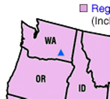
or Military bases:
(sorry about the quality of that one!!
It is just a start, remember we also have the air traffic sites for the western seaboard, so schedule flights can be corelated with mufons sighting information.
I think we need to start somewhere.
Thanks guys.
H
edit to add Mil Base in Washington
[edit on 14-4-2008 by Havalon]
Hi Internos,
If we take a State at a time, say Washington to start with, then if we pick up a concentration over, say a miltary base then we can start to look at other states. If they are over nuclear power stations then concentrate on those.
or Military bases:
(sorry about the quality of that one!!
It is just a start, remember we also have the air traffic sites for the western seaboard, so schedule flights can be corelated with mufons sighting information.
I think we need to start somewhere.
Thanks guys.
H
edit to add Mil Base in Washington
[edit on 14-4-2008 by Havalon]
You wanted the maps put together so I gave it a try... here is what I came up with on the fly.
img180.imageshack.us...

Candyman
img180.imageshack.us...
Candyman
reply to post by Havalon
Thanks Havalon: yes Washington has to be the first one in my opinion too.
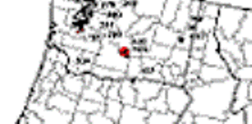
All i have to find now is a series of maps with the same scale: i have to use them as base layer, once for all: now, the mufon maps have a poor resolution, but i'm convinced that they reduced their resolution only in order to share them on the web:
In the example above, we can see that it looks like all the sightings took place near seattle, but with a better detailed map, we would probably find out that many sightings took place even out of seattle, as that there are many bases near Seattle, and the result of an overlayed map at this resolution would be a bunch of symbols one above each other. So, the better step would be, IMHO, to find the better resolution available from Mufon.
[edit on 14/4/2008 by internos]
Thanks Havalon: yes Washington has to be the first one in my opinion too.
All i have to find now is a series of maps with the same scale: i have to use them as base layer, once for all: now, the mufon maps have a poor resolution, but i'm convinced that they reduced their resolution only in order to share them on the web:

In the example above, we can see that it looks like all the sightings took place near seattle, but with a better detailed map, we would probably find out that many sightings took place even out of seattle, as that there are many bases near Seattle, and the result of an overlayed map at this resolution would be a bunch of symbols one above each other. So, the better step would be, IMHO, to find the better resolution available from Mufon.
[edit on 14/4/2008 by internos]
reply to post by internos
Thank you Internos,
I agree wholeheartedly, A better resolution map is required.
Thanks also Candyman.
Onward and upward!
H
Thank you Internos,
I agree wholeheartedly, A better resolution map is required.
Thanks also Candyman.
Onward and upward!
H
reply to post by Havalon
Ok, the people responsible for these these maps are Steve Reichmuth (www.UFOResearcher.com) and Peter Davenport ( NUFORC).
I have sent an email to Steve Reichmuth's website asking if hi-res versions are available.
Meanwhile there are slightly better maps of October, November and December Here
It's great to see your efforts Havalon, internos and the candyman
reply to post by sherpa
Thanks Sherpa,
I have emailed mufon themselves for a hi-res map of the Western seaboard sightings. So hopefully we will get the tools from one source or the other to do a detailed overlay. As Internos says, trying to do an overlay with current maps is frustrating to say the least.
It is all good stuff guys!
H
whats with the flag's? Looked in side to match up the symbol and they didnt have flags, sorry for my ignorance, but if someone can point me the right
direction would be much appreciated thanks
Good Day
Skept!cal
Good Day
Skept!cal
Originally posted by skept!cal
whats with the flag's? Looked in side to match up the symbol and they didnt have flags, sorry for my ignorance, but if someone can point me the right direction would be much appreciated thanks
Good Day
Skept!cal
Hm..good question I had not noticed that icon before, I am glad you saw it as it proves people are giveing these maps more than a cursory glance.
I don't have an answer for you I can only suggest you could perhaps contact Steve Reichmuth on his forum Here
Have a star for bringing that up.
Under the map with the flags on it, it says....
" 'Flag' symbols on these maps represent 'IFO's' or 'Hoaxes', after Mufon investigations in the field."
That should clear that up. Good post OP... enjoying it.
Candyman
" 'Flag' symbols on these maps represent 'IFO's' or 'Hoaxes', after Mufon investigations in the field."
That should clear that up. Good post OP... enjoying it.
Candyman
Originally posted by thecandyman
Under the map with the flags on it, it says....
" 'Flag' symbols on these maps represent 'IFO's' or 'Hoaxes', after Mufon investigations in the field."
That should clear that up. Good post OP... enjoying it.
Candyman
Well done Candyman.
Thats put that one to rest, I did not see that, in fact I still can't
new topics
-
Has Tesla manipulated data logs to cover up auto pilot crash?
Automotive Discussion: 59 minutes ago -
whistleblower Captain Bill Uhouse on the Kingman UFO recovery
Aliens and UFOs: 5 hours ago -
1980s Arcade
General Chit Chat: 8 hours ago -
Deadpool and Wolverine
Movies: 8 hours ago -
Teenager makes chess history becoming the youngest challenger for the world championship crown
Other Current Events: 10 hours ago -
CIA botched its handling of sexual assault allegations, House intel report says
Breaking Alternative News: 11 hours ago
top topics
-
Lawsuit Seeks to ‘Ban the Jab’ in Florida
Diseases and Pandemics: 13 hours ago, 20 flags -
Starburst galaxy M82 - Webb Vs Hubble
Space Exploration: 15 hours ago, 13 flags -
The Superstition of Full Moons Filling Hospitals Turns Out To Be True!
Medical Issues & Conspiracies: 17 hours ago, 8 flags -
CIA botched its handling of sexual assault allegations, House intel report says
Breaking Alternative News: 11 hours ago, 8 flags -
15 Unhealthiest Sodas On The Market
Health & Wellness: 15 hours ago, 6 flags -
whistleblower Captain Bill Uhouse on the Kingman UFO recovery
Aliens and UFOs: 5 hours ago, 6 flags -
1980s Arcade
General Chit Chat: 8 hours ago, 4 flags -
Deadpool and Wolverine
Movies: 8 hours ago, 3 flags -
Teenager makes chess history becoming the youngest challenger for the world championship crown
Other Current Events: 10 hours ago, 3 flags -
Has Tesla manipulated data logs to cover up auto pilot crash?
Automotive Discussion: 59 minutes ago, 0 flags
active topics
-
Lawsuit Seeks to ‘Ban the Jab’ in Florida
Diseases and Pandemics • 23 • : burritocat -
Has Tesla manipulated data logs to cover up auto pilot crash?
Automotive Discussion • 1 • : andy06shake -
15 Unhealthiest Sodas On The Market
Health & Wellness • 36 • : tanstaafl -
My wife just had a very powerful prophetic dream - massive war in Israel...
The Gray Area • 12 • : SchrodingersRat -
-@TH3WH17ERABB17- -Q- ---TIME TO SHOW THE WORLD--- -Part- --44--
Dissecting Disinformation • 606 • : burritocat -
"We're All Hamas" Heard at Columbia University Protests
Social Issues and Civil Unrest • 199 • : FlyersFan -
It takes One to Be; Two to Tango; Three to Create.
Philosophy and Metaphysics • 7 • : Terpene -
Take it to the Media when you protest.. Don't let them ignore you!
Education and Media • 4 • : SchrodingersRat -
They Killed Dr. Who for Good
Rant • 62 • : FlyersFan -
Definitive 9.11 Pentagon EVIDENCE.
9/11 Conspiracies • 421 • : Lazy88