It looks like you're using an Ad Blocker.
Please white-list or disable AboveTopSecret.com in your ad-blocking tool.
Thank you.
Some features of ATS will be disabled while you continue to use an ad-blocker.

CIT's flight path can't be impossible because we never had one
page: 3share:
Originally posted by Craig Ranke CIT
Originally posted by CaptainObvious
In the case of the 4 hijacked planes, we know what happened.
Does everyone understand the importance of the psychology behind this statement?
Absolutely, Craig.
We don't know what happened.
We were told what allegedly happened and encouraged to believe it.
We are always told what to believe for any false flag operation, without any need to enquire or argue. Then, we lose more rights as the MIC licks its lips for another war.
I stand by my quote.
You have evidence to show otherwise please present it. (please stay on topic though) This is about the Pentagon.
You have evidence to show otherwise please present it. (please stay on topic though) This is about the Pentagon.
reply to post by beachnut
I have to chime in here and say....as to Mr. Ranke and the Citgo (or CITGO) or anyway you spell, it, I've seen many differences. It is true, that darn station is there (and, yes, renamed...not sure exactly when), and if you are a civvie and drive in because of the teaser fuel prices...well, it is true, you cannot buy anything there... it stinks, IMO.
Back to beachnut, my hat's off to your excellent observations, and calculations, especially regarding bank angle and G force.
I don't have access to a calculator, or even a printed chart, to show people the relationship to the G-force that is imparted on an airplane at various bank angles, in a steady-state turn. However, one way to picture it is, at 60 degrees, it is 2 Gs. The graph, when drawn on an X-Y axis, X at the bottom being the angle of bank, and Y on the right being the G force, you will see the line exponentially rising vertically to infinity as you near 90 degrees.
Obviously, in the real world, the 'four forces' are always in play as an airplane flies. A jet 'could' reach an angle-of-bank of 77 degrees for a transient time period, and unless sufficient back-pressure were maintained to 'complete' this sort of turn, then two things will happen: Altitude and airspeed will be lost, unless thrust is increased, or altitude would be sacrificed to maintain airspeed.
Let's go back to the 60 degree angle-of-bank, since this is regularly taught to aspiring Private Pilot students. A mere 2 Gs, easy to withstand...but the exercise is designed to enhance the student's skills and ability to maintain control...it requires a smooth use of power(thrust) in the turn to maintain the initial airspeed at entry, along with the smooth reduction of power(thrust) upon exiting, and returning to level flight, on a pre-determined heading and at the initial airspeed AND altitude! It also builds confidence in a fairly new pilot, in just what (and what not) his airplane is capable of. (That's why I always taught spins, though not required...)
Professional airline pilot training still requires a variation on this skill demonstration, except we use 45 degrees of bank instead of 60. (in the simulator) Also, in airline training, +/- 5 knots airspeed, +/- 50 feet altitude, +/- 10 degrees of assigned roll-out heading.
Anyway, here's the rub: When you see an alleged 'track' of an airplane over the ground (and we ignore wind effects for now) then what's been attempted to explain here is, it's simple physics.
The radius of any 'turn' using normal flight control forces will vary according to SPEED and Angle-of-Bank. It's that simple.
A Cessna at 80K at 60 degrees AoB will 'draw' a much tighter radius of turn over the ground below, compared to a Boeing at 480K at 60 degrees AoB.
AS TO AA77...I've seen a lot of arguing, back and forth, about this track or 'that' other track over the ground, and seems to me, a lot of this was re-constructed from fairly spotty 'primary' target paints, as each radar antenna rotated around to 'paint' on each hit, so these are approximations at best. There is no PAR in the area, as far as I've known. If so, please bring that out, it would help, or possibly hurt, but it would at least be more precise. (Andrews certainly has PAR, but it's specific to their runways, besides at those altitude, even their terminal radar is likely below line-of-sight).
Ya know, the view from the cockpit of a B757 is pretty good, and even a bad pilot could fly over a point, or actually beside it, and turn to pick up a landmark that had ALREADY been decided as a landmark to use....say, Columbia Pike, for instance...and follow that road back to target.
As I said, the B757 has a great view from the cockpit.....
WW
[edit on 4/9/0808 by weedwhacker]
Originally posted by beachnut
77 degrees of bank?
Oh nonsense.
It was a constant gradual descending bank that came from east of the river exactly as described by Steve Chaconas.
You can plug your ears and cover your eyes while throwing blind punches at the evidence we have but you can't make it go away.
The plane banked around from east of the river and flew north of the citgo proving a military deception on 9/11.
reply to post by Craig Ranke CIT
EXCUSE ME!?!
Craig....a constant gradual descending bank of 77 degrees????
Or...maybe not 77 degrees, since that's not very gradual (BTW, are you a pilot at all?)
Maybe a gradual descending bank, of oh, say, a comfortable 30 degrees, say 250-300 knots in the turn, with a last-minute diving run and accelerating all the way on the final leg?
Ask someone who works at ATC...ask them what a 'Standard-Rate' turn is. Perhaps you know already.
Perhaps you know that controllers realize that the radius of the turn, the 'rate' of the turn they will expect, when they vector a large jet, is different from what they expect when they are handling a slower, smaller airplane. They already KNOW, from experience....they also, in tight, tight terminal arrival situations, such as the NYC area, slow us down so much.
250K IAS is the speed limit below 10,000 feet. Here are the standard requests, depending on the sector and the controller, and how over-worked he/she is at the moment: 'slow to 210 knots'....hand off, cleared to descend, then 'slow to 180 knots'....sometimes, in this same controller's airspace, 'increase speed to 200 knots'....which means, depending on our flap limit speeds, we have to retract from a position we had already set, due to the ATC speed restriction earlier. My favorite, though, is '150 knots' when we're still ten miles away from the airport! And you wonder why the airlines cry about wasting fuel?
Now, that was just my rant, about the real-world....of course, if you are suicidal, and don't care about getting your license suspended, then you don't follow rules.....
[edit on 4/9/0808 by weedwhacker]
reply to post by Craig Ranke CIT
'the plane banked around from east of the river...'
I am assuming you refer to the Potomac, and not the Anacostia River?
You seem to only focus on the last few minutes, and I am not accusing anything, I'm just wondering why no one ever looks at the longer view, trying to re-construct the track over the ground for the last, say, 30 minutes before impact??? Why?
Let's say, these creeps knew how to tune the VOR....certainly, all they really needed to know is to input the DCA VOR into the FMC, in the LEGS Page, press the 'EXEC' button, and 'voila' a course back to Washington DC appears on the EFIS screen right in front of them.
The Pentagon is a large building, true, but you know everything looks so much different from a high altitude, say 10000 feet...and it varies by angle...so, they get close (I'm assuming they know how to interpret the mileage info, both on the FMC and on the EFIS) and get down lower....being the ignorant, incompetent pilots that they are known to be, they passover National Airport, which you know is down-river from the 'target', shouting arabic obscenities (I imagine) followed with pleas of 'forgiveness' because they aren't that smart, but then they finally spot the 'target'....
I don't hold these creeps in very high regard, in case you might not have noticed, but they planned for this, they carried it out, amateurishly as it may have been.....
Back to the topic....let's see the entire path, or I prefer, 'track' of the airplane, over the ground. It's there, in the DFDR, the heading/wind/altitude and speed info (among other things) and co-relate that with the various radar 'hits', such as they are, knowing that without a transponder, all they could see was a 'primary' target, no computer to help them determine altitude and heading and speed, but put the times, the times from the ground-based systems, and the DVDR together, let's plot a 30-minute scenario!!
Wouldn't this be a good idea?
reply to post by weedwhacker
replying to my last post.
My apologies to another ATS member who directed me to an outside source, I printed it up and am referring to it now...
the NTSB Report, dated February 13, 2002, by John O'Callaghan and Daniel Bower, Ph.D.
Title: "Study of Autopilot, Navigation Equipment, nad Fuel COmsumption Activity Based on United Airlines Flight 93 and American Airlines FLight 77 Digital Flight Data Recorder Information"
to paraphrase, the flight was normal until, according to the report, approx 08:52 the AA77 was commandeered.
Prior to take-over, the airplane was at 35,000 feet (appropriate for a Westbound course) and the A/T engaged to hold Mach .83
[personal note: when I am in a hurry, I'll use .83, or if the headwinds are strong....we're told that .80 to .81 is more fuel-efficient...of course, they had a light load, so ...] BTW, Mach .84 is MMO, or Max Mach Operating.
What is interesting, from this NTSB report, is that the hijackers knew how to use the autopilot....well, a few hours in a simulator, and I could teach anyone to...but they were smart enough to know that they were terrible pilots, and, in that situation, the autopilot is your friend....
You see, all they had to know was....push a button, on the MCP (the panel just below the glareshield) to go into HDG SEL mode (heading select), then turn the knob right there, it makes the numbers change (think of a TV tuner) and guess what? The airplane turns to the new heading you just dialed in. Simple, eh? What's more, it is smooth, even if the bank-limit selector is still set at 25 degrees, and not 15, which is usually done after passing 18,000 feet in the climb.
Back to the report....these guys knew how to use the MCP, where you not only set heading, but altitude, and altitude changes, and also the autothrottles are operated, on the left side of the panel. As long as the A/T are engaged, you control them with the 'SPD' knob.
At 09:08, at 25,000 feet, the F/O's FD, AP and A/T all disengaged, along with the concurrent warning [very loud siren, BTW]. After about two minutes, the AP was re-engaged, on the Captain's side. ANotehr dis-connect, with siren, was re-engaged one minute later, along with the A/T
[see, these guys were in-experienced, but had some knowledge of what they were doing...kinda like monkeys....very personal thought, that]
Over the next ten minutes, the A/T was dis-engaged, and re-engaged several times [when the A/T disengages, you get a beep-beep-beep, and a yellow warning on the EICAS...no loud sirens]
They were still learning, as monkeys eventually do, to figure out what they were doing wrong, based on the few hours of training they had had previously.
At about 09:29, they were at 7000 feet and approx 30 NM from Washington....all auto systems were dis-engaged [a button on the control wheel, pressed once, disengages the AP, pressed again, silences the siren....a button on either side of the throttles, disengages the A/T]
So, from 30 miles West of the Washington DC area, at about 09:29, until impact, they were hand-flying the airplane. At 7000, or 5000 feet, dropping down to see landmarks and make the final run......
Comments? Questions?
WW
Originally posted by weedwhacker
reply to post by Craig Ranke CIT
EXCUSE ME!?!
Craig....a constant gradual descending bank of 77 degrees????
Or...maybe not 77 degrees, since that's not very gradual (BTW, are you a pilot at all?)
Maybe a gradual descending bank, of oh, say, a comfortable 30 degrees, say 250-300 knots in the turn, with a last-minute diving run and accelerating all the way on the final leg?
Of course it wasn't 77 degrees.
That's just the beachnut making stuff up.
No I'm not a pilot.
I am a citizen investigator and I only accept independent verifiable evidence in regards to the Pentagon attack.
My partner and I have spoken with dozens of witnesses, first responders, and vicitms and we can prove a military deception on 9/11.
Watch the 10 minute presentation I posted above (higher quality version here) to see a groundbreaking interview we conducted proving the plane came from east of the Potomac.
This proves the NTSB and 84 RADES data fraudulent.
reply to post by weedwhacker
They are making up the flight path of 77 on their own. Their witnesses saw the C-130 fly by and they are saying it was Flight 77. This is all support by "hard evidence", called RADAR data. The radar data shows the C-130 flying the departure from Andrews, took off to the north and heads west (variation is not understood by CIT) on course flying the instrument departure . They think when the C-130 pilot said he had flew south of the MALL and had could see the MALL, the pilot was over the Mall by 100s of feet. It was miles. Tried to explain the Mall is two miles long and south of the Mall is not next to the Mall. They do not understand why the RADAR data confirms both the pilot's statements and departure flown.
They make up fake paths for 77, and the C-130 just based on their interpretation of terms, like "south". I wonder what they would think if I said I was flying and could see Beale to the east? Would they know I was talking about 200 miles away? It was a beautiful view of Beale, I was west and could see the ramp lights, from my cruise attitude, FL410. I do not think they have experience flying.
Watch the video and see the guy confirm the exact path of the C-130. CIT has accused me and my brother military members of faking the RADAR data. I never knew I was accused of murder on 9/11, but now I am. No evidence just faulty analysis of witness statements. The same witnesses who in 2001 said they saw 77 hit the Pentagon.
[edit on 9-4-2008 by beachnut]
Originally posted by weedwhacker
Comments? Questions?
WW
The NTSB data has been proven fraudulent by the independent witnesses.
The plane did not do this:
It did something more like this:
We prove it with multiple lines of independent corroborating evidence.
The official data released many years after the event is not backed up with any independent evidence.
The plane came from east of the Potomac and flew north of the former CITGO station proving a military deception on 9/11.
reply to post by beachnut
beachnut....I understand completely.
A C-130....which most non-pilots would have know idea anyway...is not going to be a 'drone' or somehow 'fake' an attack!!!
Folks, a C-130 does not fly at the same speeds as a commercial jet! It is a four-engine, high-wing turbo-prop....the one you see dropping supplies out its rear....because it has a ramp, in the aft fuselage, for loading, and un-loading....and it can be opened in flight, because it was designed that way!!
Top speed....I don't know, it's a turbo-prop....300 knots? Maybe 320?
See, an airplane being propelled by a 'propellor' has certain limitations...
One of them, being maximum speed. BUT, they, the C-130s, can also have great advantages over jets...as in, the ability to haul great payloads into very short runways...and also take-off from those short runways. See? Different missions, different airplanes, different designs.
It's all in the compromise, in aircraft design......
reply to post by Craig Ranke CIT
Which witnesses? Your witnesses? Several of whom saw the plane hit the pentagon!
multiple lines? In your OP you state:
Cant you just leave it at that? You could have stated that in one thead, then you and your "partner" Aldo could have lived together happily ever after.
Think about it. For the love of god, please think about it.
CT
PS So how is having your own forum coming along? You know the one where you post responses to debunking in other forums because you and your "partner" have been banned from most of the others?
The NTSB data has been proven fraudulent by the independent witnesses.
Which witnesses? Your witnesses? Several of whom saw the plane hit the pentagon!
We prove it with multiple lines of independent corroborating evidence
multiple lines? In your OP you state:
The only thing we say we have proven is the very general claim that the plane came from east of the river and flew north of the citgo.
Cant you just leave it at that? You could have stated that in one thead, then you and your "partner" Aldo could have lived together happily ever after.
Think about it. For the love of god, please think about it.
CT
PS So how is having your own forum coming along? You know the one where you post responses to debunking in other forums because you and your "partner" have been banned from most of the others?
reply to post by Craig Ranke CIT
Well, I am not a 'quote puller', or 'quote wrangler'....I just don't do that.
I will simply note: I asked Craig Ranke if he was a pilot, and, to his credit, he said: "No, I'm not a pilot"
So that was honest, and I appreciate it.
Having said that (you know, there's always a 'but'...)
I wrote a few very long posts....some that went long because I needed to 'flesh' them out, in order to provide context...but I asked, 'Why not show the entire last 30 minutes of AA77?'
Well, I didn't use those exact words, you can scroll up and read it yourselves....but, I was using a printed copy I have, from the NTSB, a summary, not the 'official' report...[personal note: I put official in quotes because, if you've not read any NTSB reports before, they get very detailed and very long...that's why a summary is useful]
Let's back-track. At 09:29 AA77 was at approx 7000 feet and 30 NM from target. It appears, based on DFDR data, to have been taken over at approx 08:52. That is 37 minutes elapsed, so far. When was impact? Add in the minutes....
Now, a Cockpit Voice Recorder has an approx 30 minute continuous-loop audio tape, so the 'take-over' would be 'taped-over'....but modern science can sometimes glean info, even from tapes that are 'taped' over...
The DFDR does not conform to this 30-minute criteria....something like 120 hours of past data are recorded. So, we should be able to read it all...and, in fact, that's just what the NTSB summary that I referrenced earlier, noted.
It is well-known, or at least, should be well-known, that actual audio tapes from a CVR are NEVER....and I emphasize....NEVER released to the public. This is in deference to the families and loved ones, and I think it is an honorable policy.
However, the ATC tapes are allowed to be released, and many of you have probably heard a few....and if the pilots involved have died, then, in deference to family...maybe their voices have been edited out, with others in their place. I have NO IDEA if this happens, it's just a thought. The idea of my loved one's voice being replayed, over and over on the media, after his death, would tear out my heart, as I think, it would tear out anyone's.
I can only provide one example, to what I am trying to convey. IN August 1987, in Detroit, a NorthWest MD-80, bound for Phoenix, crashed during take-off. ONE person survived....a little girl...out of nearly 165 people, including two on the ground. [think of this, when you consider the passport in NYC]
Why did this accident happen? Pilot error, and that's why it was studied, and shown to us in our re-current training, as a warning to not let it happen to us. Confusion during the taxi led to poor checklist compliance, and they forgot to set the flaps/slats for take-off. Contributing, and still unexplained, is why there was no 'Config' warning....but we'll never know.
Point is, we heard the 'transcript', as read by actors, as the scenario was computer generated in a video, as an educational tool, to prevent further occurences. BUT!! No actual voices were used, and that is my point, from up above.
I think, sometimes, simple questions are asked....and there are no simple answers. People try to provide 'simplistic' answers to complex questions....sometimes I just grit my teeth, and move on, but sometimes I try to impart a little bit of knowledge into a realm that I happen to know something about, and can pontificate on.
Sorry if I seemed to rant....
WW
The NTSB data is not proven wrong. You are just saying it is wrong and making up the story. Your own witnesses put 77 on the 61.2 degree true track on 9/11. Proof your statement is wrong. These are you "hard evidence" indisputable witnesses and they prove you wrong. You have taken their words and change them as we watch your video.
Originally posted by Craig Ranke CIT
Originally posted by weedwhacker
Comments? Questions?
WW
The NTSB data has been proven fraudulent by the independent witnesses.
We prove it with multiple lines of independent corroborating evidence.
The official data released many years after the event is not backed up with any independent evidence.
The plane came from east of the Potomac and flew north of the former CITGO station proving a military deception on 9/11.
Your evidence is manufactured by taking quotes and misinterpreting them from you witness statements which your call "hard evidence". Witness statements? Your proof is made up using faulty logic from your flawed interpretation of witness statement. You have zero physical evidence. The physical evidence lies along a 61.2 degree heading to the impact point at the Pentagon. You use the line up error by the NTSB, but ignore the real data from the FOR, recovered from the Pentagon, showing the previous 25 hours of operation of Flight 77.
No, the Plane did not come from the east, it is clearly found on RADAR data. It is absurd to say the RADAR data is fake. You have zero evidence and it has not been collaborated by a board of experts independent of the truth movement groups. Your boat witness watched the C-130 go over and you now say it is flight 77. Flight 77 was seen by KDCA tower people on the flight path seen on the RADAR data, the same plane they saw with eyes and RADAR in the tower; This testimony you have twisted to your made up flight path over DC. It is unbelievable how you take good witnesses and ruin the data.
So you just say everything is fake, yet your own witnesses do not support your ideas on the Pentagon. You even make up stuff about them. If someone saw 77 impact the Pentagon, you say "they ducked" and missed it. Wow, just change their words to match you fantasy. No evidence, just witness statements you change to fit your story.
And how many paths have you published, and you say you do not have?
reply to post by Craig Ranke CIT
Craig, you put up two 'maps'....the first one, on top, a red herring, obviously, since I already explained how they navigated back to the DC area....they used the DCA VOR! This VOR is located at National Airport, which is SOUTH of the Pentagon!
Then your second picture....that's just completely made up!.....
Again, these creeps dropped down, as they came from the West, to about 7000 feet, since they were, after all, small-airplane pilots, at least their 200-hour or so experience, and this is what they were ued to seeing....but they're flying a jet much faster that they were used to, so they learned to adapt, after a few minutes...
Craig, you are not a pilot, so I wouldn't expect you to understand. Others here, on ATS ARE pilots, so they know what I mean.
So, they were manually flying, saw the 'target', circled around, lined up on the pre-planned course, which is Columbia Pike, since it is a prominent road in the area, and leads directly to the 'target'....and shoved the throttles to the firewall and just drove the airplane into the 'target', making small corrections....visually...as you would do if your were steering your Ferarri into a brick wall at maximum speed!
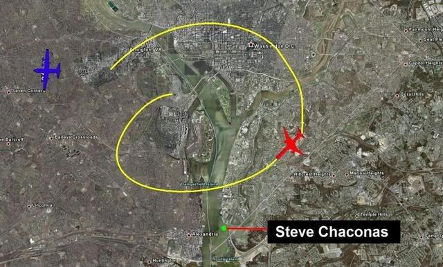
EDIT.....I just looked, again, at your second picture, Craig....and it looks as if you located your 'observer' Mr. Chaconas on the Maryland side of the potomac, to the East and slightly SOUTH of Alexandria, VA, on the other side of the river?!? Is this your contention?!?
Do you have any idea how far away that is from the 'target'? Sheesh, it's about 3 miles (or more) away from National Airport!! AND the target is UP-river from there!
Care to elaborate?
[edit on 4/10/0808 by weedwhacker]
Craig, you put up two 'maps'....the first one, on top, a red herring, obviously, since I already explained how they navigated back to the DC area....they used the DCA VOR! This VOR is located at National Airport, which is SOUTH of the Pentagon!
Then your second picture....that's just completely made up!.....
Again, these creeps dropped down, as they came from the West, to about 7000 feet, since they were, after all, small-airplane pilots, at least their 200-hour or so experience, and this is what they were ued to seeing....but they're flying a jet much faster that they were used to, so they learned to adapt, after a few minutes...
Craig, you are not a pilot, so I wouldn't expect you to understand. Others here, on ATS ARE pilots, so they know what I mean.
So, they were manually flying, saw the 'target', circled around, lined up on the pre-planned course, which is Columbia Pike, since it is a prominent road in the area, and leads directly to the 'target'....and shoved the throttles to the firewall and just drove the airplane into the 'target', making small corrections....visually...as you would do if your were steering your Ferarri into a brick wall at maximum speed!
EDIT.....I just looked, again, at your second picture, Craig....and it looks as if you located your 'observer' Mr. Chaconas on the Maryland side of the potomac, to the East and slightly SOUTH of Alexandria, VA, on the other side of the river?!? Is this your contention?!?
Do you have any idea how far away that is from the 'target'? Sheesh, it's about 3 miles (or more) away from National Airport!! AND the target is UP-river from there!
Care to elaborate?
[edit on 4/10/0808 by weedwhacker]
Originally posted by weedwhacker
Craig, you put up two 'maps'....the first one, on top, a red herring, obviously, since I already explained how they navigated back to the DC area....they used the DCA VOR! This VOR is located at National Airport, which is SOUTH of the Pentagon!
Umm...the first picture is THE actual NTSB flight path that allegedly came from the black box. It is their image.
Then your second picture....that's just completely made up!.....
No it is not.
It is based on independent first hand testimony that we provide filmed ON LOCATION.
Please watch the interview with Steve Chaconas that I already posted above, then watch our interview with Jamal at the Army Navy Country club in our presentation "Flight 77" The White Plane and then watch all the interviews from all the witnesses who were at the citgo station in The PentaCon Smoking Gun Version.
The entire flight path is fully supported while there is ZERO independent evidence that supports the NTSB flight path.
So, they were manually flying, saw the 'target', circled around, lined up on the pre-planned course, which is Columbia Pike, since it is a prominent road in the area, and leads directly to the 'target'....and shoved the throttles to the firewall and just drove the airplane into the 'target', making small corrections....visually...as you would do if your were steering your Ferarri into a brick wall at maximum speed!
This is what you were told and imagined.
I am backing up all of my claims with independent evidence.
Big difference.
EDIT.....I just looked, again, at your second picture, Craig....and it looks as if you located your 'observer' Mr. Chaconas on the Maryland side of the potomac, to the East and slightly SOUTH of Alexandria, VA, on the other side of the river?!? Is this your contention?!?
Do you have any idea how far away that is from the 'target'? Sheesh, it's about 3 miles (or more) away from National Airport!! AND the target is UP-river from there!
Care to elaborate?
Yes that is where Steve was.
It's actually about 5 miles away.
It was the perfect place to see the plane approach from east of the river proving the NTSB and 84 RADES data fraudulent.
Have you watched the interview?
Please do and watch all the interviews I linked because that is real evidence.
Since you live in the area you should find them rather interesting since they were all filmed on location.
reply to post by Craig Ranke CIT
one moment Craig Ranke, just to acknowledge that I saw you last post.
I will now go to your links, and talk to you afterwards.
WW
[edit to add]
I did not imagine your video links would be so long. I got as far as 1400 S. Barton I actually know where that is, so I'll drive over tomorrow.
Ya know, don't you, that Arlington is laid out alphabetically? Going up from the River, the street names are one syllable, alphabetically, then two syllable, again, alphabetically, and so forth until you hit Fairfax County!!!!
Oh, and the line between 'north' adresses and 'south' addresses? Route 50.
Hey! I used to live on North Garfield Street, in Arlington, so don't try to fool me, OK?
ps....I know all about Columbia Pike....that's why I tell people to Google Map it, to see for themselves....
WW
[edit on 4/10/0808 by weedwhacker]
Originally posted by tezzajw
Originally posted by Craig Ranke CIT
Originally posted by CaptainObvious
In the case of the 4 hijacked planes, we know what happened.
Does everyone understand the importance of the psychology behind this statement?
Absolutely, Craig.
We don't know what happened.
To Craig and Jawa:
Are we TRYING to find problems with fellow members' mindsets here? Consider it this way, the way he probably meant it;
in this case for investigative purposes, they OFFICIALLY 'knew' what happened and the cause of aircraft failure. Therefore a normal re-assembly investigation thing to determine the cause would not be needed. It is not NECESSARILY a sign that they were trying to cover up the fact that they had only missile debris and a few scraps from the Amazon to work with.
And back to the flight path CIT never had
except in the vague sense that it totally proved the 'official story' wrong...
Craig: This is an interesting thread, and I commend you for clarifying that there is some speculation that goes into CIT's work after all, and that you don't take your tentative proposal as gospel. I understand general findings and not flight paths are your thing - east of the river, north of the station, alright. But this is about a plane, and planes of course don't fly in general findings, they travel along flight paths if they're real. A flight path must be first, possible and second, consistent with the evidence. So a flight path proposal, or a range of possibilities, is very important to check if your conclusions make sense.
CIT never had a flight path? They need to get one. You've been on the case since late 2006 at least, so it's only getting later.
I have only one concrete question to start with; how is CIT thinking about Jamal ElKournayti's account? I feel your original tentative path accurately and almost exactly reflected what he said.
Unfortunately, that's a big part of where your tentative proposal got all impossible. If the plane was a bit north of where he thought it flew that would help reduce the banking needed to get north of the Annex. So do you feel this might be the case, the yellow path just read him too literal? (perspective, right?)
Maybe if you have time, trace out some variants that could match his account, and then working with the three variation of the NoC path we can start thinking about the middle stretch.
[edit on 10-4-2008 by Caustic Logic]
Originally posted by Craig Ranke CIT
Originally posted by weedwhacker
Craig, you put up two 'maps'....the first one, on top, a red herring, obviously, since I already explained how they navigated back to the DC area....they used the DCA VOR! This VOR is located at National Airport, which is SOUTH of the Pentagon!
Umm...the first picture is THE actual NTSB flight path that allegedly came from the black box. It is their image.
weedwhacker, I will be interested to read your explanation of why the first map is a 'red herring' when it is the official NTSB map of the alleged flight path?
Please, explain what the map should look like. Even better, if your computer graphic skills extend to using Paint, or something similar, then perhaps you could draw in the alleged flight path for us?
Originally posted by Craig Ranke CIT
Originally posted by nicepants
The path above requires the plane to be in a bank when it flies past the citgo, but your witnesses report that the wings were level. Not only that, look at how many Gs you're pulling. Then, of course, the fact that when it reaches the Pentagon it's too far north.
Actually you are wrong.
ATC Sean Boger was in the heliport tower and is the only one who had a view of the plane AS it approached and continued past the citgo on the north side and he most certainly DOES report the plane as banking over the Navy Annex.
[edit on 9-4-2008 by Craig Ranke CIT]
Sean Borger? You mean the guy who saw and heard the plane fly right into the building?
The path you drew would have the plane banking as it flew past the citgo, so those witnesses would have seen it too.
Also, it doesn't reach the pentagon at the impact point, but further north.
Originally posted by Craig Ranke CIT
Oh and please tell me how to "look" at "G's".
Do the math and you'll understand.
Originally posted by Craig Ranke CITThere is nothing unreasonable about that flight path at say 2 or 300mph which would still seem quite fast at such a low altitude.
The plane would have had to have been going approx 80 mph to pull off that maneuver, which would put it into a stall..
This is a simple way to find out if your witnesses are right....do the math, if it doesn't add up then they were clearly wrong. (Now I understand why you don't want to do the math)
new topics
-
SETI chief says US has no evidence for alien technology. 'And we never have'
Aliens and UFOs: 44 minutes ago -
This is our Story
General Entertainment: 3 hours ago -
President BIDEN Vows to Make Americans Pay More Federal Taxes in 2025 - Political Suicide.
2024 Elections: 5 hours ago -
Ode to Artemis
General Chit Chat: 6 hours ago -
Ditching physical money
History: 9 hours ago -
One Flame Throwing Robot Dog for Christmas Please!
Weaponry: 10 hours ago -
Don't take advantage of people just because it seems easy it will backfire
Rant: 10 hours ago -
VirginOfGrand says hello
Introductions: 11 hours ago -
Should Biden Replace Harris With AOC On the 2024 Democrat Ticket?
2024 Elections: 11 hours ago
top topics
-
University student disciplined after saying veganism is wrong and gender fluidity is stupid
Education and Media: 14 hours ago, 14 flags -
Police clash with St George’s Day protesters at central London rally
Social Issues and Civil Unrest: 17 hours ago, 10 flags -
President BIDEN Vows to Make Americans Pay More Federal Taxes in 2025 - Political Suicide.
2024 Elections: 5 hours ago, 10 flags -
Should Biden Replace Harris With AOC On the 2024 Democrat Ticket?
2024 Elections: 11 hours ago, 6 flags -
One Flame Throwing Robot Dog for Christmas Please!
Weaponry: 10 hours ago, 5 flags -
Ditching physical money
History: 9 hours ago, 4 flags -
Don't take advantage of people just because it seems easy it will backfire
Rant: 10 hours ago, 4 flags -
God lived as a Devil Dog.
Short Stories: 15 hours ago, 3 flags -
VirginOfGrand says hello
Introductions: 11 hours ago, 2 flags -
Geddy Lee in Conversation with Alex Lifeson - My Effin’ Life
People: 15 hours ago, 2 flags
active topics
-
University student disciplined after saying veganism is wrong and gender fluidity is stupid
Education and Media • 30 • : KrustyKrab -
Republican Voters Against Trump
2024 Elections • 288 • : burritocat -
SETI chief says US has no evidence for alien technology. 'And we never have'
Aliens and UFOs • 3 • : gortex -
Police clash with St George’s Day protesters at central London rally
Social Issues and Civil Unrest • 38 • : ohahhupthera -
Spectrophilia - Women Who Have Had Affairs With Ghosts Say Spooks Are Better Lovers Than Real Men
Paranormal Studies • 29 • : burritocat -
Should Biden Replace Harris With AOC On the 2024 Democrat Ticket?
2024 Elections • 45 • : burritocat -
Ditching physical money
History • 14 • : DerBeobachter2 -
British TV Presenter Refuses To Use Guest's Preferred Pronouns
Education and Media • 129 • : KrustyKrab -
-@TH3WH17ERABB17- -Q- ---TIME TO SHOW THE WORLD--- -Part- --44--
Dissecting Disinformation • 637 • : burritocat -
The Reality of the Laser
Military Projects • 33 • : ADVISOR