It looks like you're using an Ad Blocker.
Please white-list or disable AboveTopSecret.com in your ad-blocking tool.
Thank you.
Some features of ATS will be disabled while you continue to use an ad-blocker.

strange bunker on outskirts of Area 51
page: 1share:
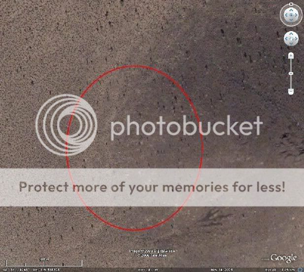
it may have already been seen or discussed but i was flying around google earth looking at area 51 at work today and when i went just northeast of the
main part of the base I noticed something in the mountain so i zoomed in to these coordinates
37°27'0.62"N 115°44'43.38"W
only to find what looks to be a bunker in the mountain... but why so far from the main part of the base... i mean, walking on foot from racheal, NV you could hike through the mountain to that point from the north... i believe there are no roads up there that any 'camo guy jeeps' could track you but there is a dirt road leading from the main part of the base to the spot and there are what appears to be turn around roads right at the entrance to the bunker in the mountain. any thoughts or theory's... i mean if its intended to be so far away... could be waste storage possibly? but if its not that then what would they store so far from 'home'
reply to post by darthdescendent
I'm not sure what about that image makes you think its a bunker?
sure there is a little building the size of a garage there, but i don't see any blast doors, or air handling anywhere near it - it could just be a weather station, or a geological survey...
and i've just found this, which suggests what you are seeing is comms gear...
www.abovetopsecret.com...
[edit on 1/3/08 by rat256]
Originally posted by darthdescendent
it may have already been seen or discussed but i was flying around google earth looking at area 51 at work today and when i went just northeast of the main part of the base I noticed something in the mountain so i zoomed in to these coordinates
37°27'0.62"N 115°44'43.38"W
only to find what looks to be a bunker in the mountain... but why so far from the main part of the base... i mean, walking on foot from racheal, NV you could hike through the mountain to that point from the north... i believe there are no roads up there that any 'camo guy jeeps' could track you but there is a dirt road leading from the main part of the base to the spot and there are what appears to be turn around roads right at the entrance to the bunker in the mountain. any thoughts or theory's... i mean if its intended to be so far away... could be waste storage possibly? but if its not that then what would they store so far from 'home'
If you pan a little further east, to the top of the peaks, you will see Bald Mountain Radar Station 1 and 2. The "bunker" might be associated that - some type of fuel cell for power perhaps?
37°27'0.89"N, 115°44'4.59"W
[edit on 1-3-2008 by FosterVS]
i see the comm station at the top of the mountain i just find it odd that there is so much road for turn around and such for something as small as a
geo survey station or comm's gear... plus there are no lines going up the mountain unless underground of course but it just seems to me that if bald
mountain comm station isn't part of area 51 then what i was looking at is due to the fact that the road goes right to the base itself... just seems a
bit more then what you suggested but i could be wrong im not about to argue anyone on this... just wanted to post what i found.
thanks for the replies
thanks for the replies
reply to post by darthdescendent
i agree there does seem to be a lot of road, but what i don't see is anything that actually looks like a tell tale bunker...
i guess thats the closest access for anyone needing to get to the towers on the top as well, which might explain it.
i agree there does seem to be a lot of road, but what i don't see is anything that actually looks like a tell tale bunker...
i guess thats the closest access for anyone needing to get to the towers on the top as well, which might explain it.
According to the ufomind.com website, Bald Mountain is serviced via helicopter. I haven't seen this done. No one talks about how the fuel for the
facility is delivered. That building may be the end of the line for the ground crew.
The road may be wide to make things more manageable for winter travel. Often in Nevada they use a tracked vehicle to make it to the top of these high altitude repeater sites. On the ufomind.com website, there is mention of a tracked vehicle, which I assumed was to reach the top of Halligan Mesa.
If you have ever tried to climb Tikaboo too soon in the year, you can see how these mountain tops have their own microclimate. Not simply colder, but also a higher moisture content
That building might be something to do with testing RCS or ELINT gear perhaps? They'd need a nice little isolated spot to keep away from all the
electronic crap in the air at Groom I presume.
reply to post by DeltaNine
The building is in the shadow of air traffic control radar (Bald Mountain), so that would rule out any weak signal systems.
The building is in the shadow of air traffic control radar (Bald Mountain), so that would rule out any weak signal systems.
I don't like you, that's the second post of mine today you've discredited! :p
i've never even seen a51. anyone want to "risk" getting really really close?
I'm somewhat convinced the straight road leading up the hill toward the "shack" is a power line road. You see these a lot in the desert. No matter
how insane the route, they can route the wire. So maybe the shack is a substation.
www.lazygranch.com/temp/bmpls.kmz
marks what may be power poles. The resolution is not very good on google earth in that area.
www.lazygranch.com/temp/bmpls.kmz
marks what may be power poles. The resolution is not very good on google earth in that area.
does anyone know the coordinates to the 6 ish ufo bunkers near area 51?
Originally posted by nzldude
does anyone know the coordinates to the 6 ish ufo bunkers near area 51?
Are you referring to the UFO hangers at S-4 as claimed by Bob Lazar?
Originally posted by nzldude
yeah, im sure that it was operational till a few years back.
Really? Well here is exactly where Lazar claims the S4 hangars are/were:
Notice there are no access roads, trails, etc. No sign of any activity. Considering he claimed he was taken from A51 to this site by a bus with blacked out windows, how could said bus get there minus a road - unless of course it is that secret anti-gravity bus... Frankly I think Lazar is full of crap. However I am sure there are a multitude of Lazar threads here on ATS.
oh well thanks for the info man. i've heard that there are some bunkers near area 51 that house some of the more 'need to know' technology but
had no hard evidence of the fact
reply to post by FosterVS
Foster, nice pic to discredit lazar. i am always on the fence about lazar, but it seems the more info that comes out, the harder it gets to buy into him. what are the coordinates for lazar's site? Id love if someone could show lazar that pic and just capture the blank stare look that would inevitably be on his face.
Foster, nice pic to discredit lazar. i am always on the fence about lazar, but it seems the more info that comes out, the harder it gets to buy into him. what are the coordinates for lazar's site? Id love if someone could show lazar that pic and just capture the blank stare look that would inevitably be on his face.
Originally posted by bknapple32
reply to post by FosterVS
Foster, nice pic to discredit lazar. i am always on the fence about lazar, but it seems the more info that comes out, the harder it gets to buy into him. what are the coordinates for lazar's site? Id love if someone could show lazar that pic and just capture the blank stare look that would inevitably be on his face.
Sorry, I should have put the coordinates in my post.
37°6'51.92"N 115°50'19.13"W
I saw a document or picture or something at some point (on Lazar's website I believe) that showed the general area, and S-4 is known to be south of the A51 base, so it was quite easy to pinpoint the spot.
"Id love if someone could show lazar that pic and just capture the blank stare look that would inevitably be on his face."
Considering what I have seen on GE in the Netherlands (see "GoogleMaps: bad job at hiding 'sensitive information' guys.... (picture)" thread) I guess it would be fairly easy to obscure the details in that area. Might be interesting to have a look at some other satellite photos pre-GE to see any differences.
reply to post by FosterVS
hi there,
can you please explain a little more on what you meant re:the subject of GE in Holland ??
thanks
snoopyuk
hi there,
can you please explain a little more on what you meant re:the subject of GE in Holland ??
thanks
snoopyuk
reply to post by FosterVS
I could of sworn I saw a pre GE photo of the S-4 area... might have been supplied by Lazar himself, with a distinct road that leads to nothing. Thats what kept me on the fence about him. I ll try looking for it today. In you picture I looked where the road would have been and it seems to look like a faint trail but not a road, could easily be photo shopped though, who knows. I'll lean on the side of caution however...
I could of sworn I saw a pre GE photo of the S-4 area... might have been supplied by Lazar himself, with a distinct road that leads to nothing. Thats what kept me on the fence about him. I ll try looking for it today. In you picture I looked where the road would have been and it seems to look like a faint trail but not a road, could easily be photo shopped though, who knows. I'll lean on the side of caution however...
new topics
-
Nirvana - Immigrant Song
Music: 1 hours ago -
British TV Presenter Refuses To Use Guest's Preferred Pronouns
Education and Media: 2 hours ago -
Tucker Carlson interviews Christian pastor from Bethlehem.
Middle East Issues: 4 hours ago -
Trump To Hold Dinner with President of Poland At Trump Tower Tonight
2024 Elections: 4 hours ago -
A family from Kansas with six children moved to the Moscow region
Other Current Events: 7 hours ago -
Revolution in advertising: the Russians launched a unique satellite
Science & Technology: 9 hours ago
top topics
-
I Guess Cloud Seeding Works
Fragile Earth: 15 hours ago, 14 flags -
Trump To Hold Dinner with President of Poland At Trump Tower Tonight
2024 Elections: 4 hours ago, 7 flags -
Canadian Forces bow out and loose interest in UFO’s
Aliens and UFOs: 15 hours ago, 6 flags -
Revolution in advertising: the Russians launched a unique satellite
Science & Technology: 9 hours ago, 5 flags -
A family from Kansas with six children moved to the Moscow region
Other Current Events: 7 hours ago, 4 flags -
Tucker Carlson interviews Christian pastor from Bethlehem.
Middle East Issues: 4 hours ago, 4 flags -
Echo & The Bunnymen - The Killing Moon!
Music: 12 hours ago, 3 flags -
British TV Presenter Refuses To Use Guest's Preferred Pronouns
Education and Media: 2 hours ago, 1 flags -
Nirvana - Immigrant Song
Music: 1 hours ago, 1 flags
active topics
-
It has begun... Iran begins attack on Israel, launches tons of drones towards the country
World War Three • 826 • : matafuchs -
British TV Presenter Refuses To Use Guest's Preferred Pronouns
Education and Media • 9 • : Consvoli -
The Acronym Game .. Pt.3
General Chit Chat • 7718 • : bally001 -
Candidate TRUMP Now Has Crazy Judge JUAN MERCHAN After Him - The Stormy Daniels Hush-Money Case.
Political Conspiracies • 268 • : matafuchs -
Revolution in advertising: the Russians launched a unique satellite
Science & Technology • 48 • : RussianTroll -
Trump To Hold Dinner with President of Poland At Trump Tower Tonight
2024 Elections • 5 • : Boomer1947 -
USO 10 miles west of caladesi island, Clearwater beach Florida
Aliens and UFOs • 9 • : matafuchs -
Marjorie Taylor Greene Files Motion to Vacate Speaker Mike Johnson
US Political Madness • 56 • : xuenchen -
-@TH3WH17ERABB17- -Q- ---TIME TO SHOW THE WORLD--- -Part- --44--
Dissecting Disinformation • 501 • : cherokeetroy -
Tucker Carlson interviews Christian pastor from Bethlehem.
Middle East Issues • 11 • : andy06shake