It looks like you're using an Ad Blocker.
Please white-list or disable AboveTopSecret.com in your ad-blocking tool.
Thank you.
Some features of ATS will be disabled while you continue to use an ad-blocker.

The Smoking (Anti-Aircraft) Guns (of Los Angeles, 1942)
page: 5share:
I hope this offers a couple of new doors for investigation, but I have to say up front that this is anecdotal: As a member of MUFON-GA in 2003-2004, I
attended a meeting (can't remember if it was the end of 2003 or early 2004) hosted by a particular member who had done a bit of research on this
topic, presented it with a powerpoint presentation, and I think may have been planning a related book. I am no longer a member of MUFON-GA, having
moved to NY last year. I am currently trying to track down the aforementioned MUFON-GA member to see if he would be willing to contribute to this
thread. (But given that I recall him talking about working on a book about this topic, he may not be more forthcoming beyond what I'm about to
relate):
Here's what I remember from the presentation of evidence; again, this is purely anecdotal at this point, since I haven't done the research myself, though I'm hoping this maybe helps point your diligent researchers in the right direction:
Regarding the AA batteries and the klieg lights: One potential reason for secrecy surrounding this event is that this was a first-time military use of a system that incorporated using a mobile radar attached to the klieg lights attached to the mobile guns. So that perhaps makes somewhat irrelevant the discussion of the placement of the guns and lights; I do not recall from the research that person X did whether the guns were emplaced or mobile mounts that could be mounted on any available hilltop. However, of greater importance (at least to him) was that the system being employed was locking onto a single blip, which caused all of the lights to be focused in that area, and which caused the related guns to be focused along the same paths. The significance here (according to person X) is that multiple separate batteries employing the same new defense system all locked onto the same target, which caused the related guns to fire on that same target. If I remember correctly, he backed his claims via FOIA requests related to the deployment of this heretofore classified system of radar tracking tied to the illuminating units and firing units. Again, my recollection is that these were highly mobile, thus looking at map placements now for emplaced batteries may not yield much in terms of a logistical placement of either the lights in the photo nor the size and placement of the object itself. Rather, a look at the placement of these mobile units would be a better place to investigate.
If I remember correctly, the number of these units was either 12 or 15. I think that not all of the units locked onto the target at first but that eventually all did. Whether or not that's true, that may lead to an explanation for additional 'beam width' for some of the spotlights in the photo in question. Assume perhaps 12 spots at a minimum. Again, the lock-on was radar controlled regarding the lights. The guns were firing up the light beams, assuming the kliegs had radar lock on a solid target.
There was more physical evidence of the incident beyond the 3 direct and 3 indirect deaths: there was also property damage. Some of that was associated with the 'direct' deaths. Further damage included damaged car and house roofs from falling debris.
Obviously, no craft was actually shot down. After hovering throughout the battle, visual reports have the 'craft' moving south down the coast and then west out to sea, where it was eventually lost to radar contact.
It's my understanding that the negative of the LA Times photo no longer exists. For anyone who claims differently and would use that for a basis for photo analysis, I'd appreciate some info on where I might be able to examine it.
WFA: I am working on identifying the person I refer to as 'person X' who did a bit of this legwork a few years ago. If I have any more info, I will pass it along. In the meantime, I suggest per what I commented on above, looking into classified radar arrays deployed in LA at that time.
If the Santa Monica mountaiins had logging or fire break roads at the time they would be an ideal location to hide mobile AA batteries.
37th CA Brigade
www.envirostor.dtsc.ca.gov...
With a map showing the roads and the camp (now appears to be an airport)
www.multimap.com...|NANDINA%20AVE%20AND%20FWY%20215#t=l&map=33.873,-117.26091|15|32
Yes, confirmed, it is March AFB.
well, that's the attacking brigades base.. but where were they deployed?
Unless they were posted at the base as protection for it, although the reports of the Object(s) under fire were from santa monica to long beach which is miles away from riverside.
Also;
www.americanchronicle.com...
My point is, how did the 37th CA brigade at riverside shoot at anything near Los Angeles or Santa Monica?
And if the object(s) took 30 minutes to fly between Santa Monica and Long Beach, what were the gunners shooting at for the other 30 minutes?
My only theory on this is that there was more than one object.
And according to some of the reports, they may have been ready for the arrival of whatever it was that flew over.
But that report only states one object, not multiple.
Bearing in mind the disinformation that's been dished out too, I think it's safe to say there was only one object and someone was definitely shooting at it and it is more than likely to be the 37th based at camp Haan.
The Los Angeles area was a major supplier and manufacturer of all of Americas WW2 equipment and aircraft. So the observation of this area by ANYONE would have been a major upset for the US government.
Once we have finally worked out the location of the ridge in the photograph, we may be able to decide fact from fiction.
If aircraft were in the air that night, then it may have been them that flew between Santa Monica and Long Beach. the object over Los Angeles may have moved off towards where the 37th were at their posts. The Santa Monica aircraft may have been the decoys to avert attention away from the real object that was fired at and caught on camera. It seems to me that the ridge was deliberately used in the photo to be able to establish the size of the craft.
The ridge was used as a reference point. I'm not sure on the terrain between Santa Monica and Long Beach, but from what I've seen so far, it would appear to be a pretty low lying area.
One way to explain the hour long firing is if the object flew in a direct line over all the guns, the first gun begining firing as soon as object was in range, and so on until the it passed the last guns range. But the range given by LazyGuy on page 2 is Max horizontal range 12,400/10,900 yards.
So you would only have two guns firing at a range of an extra (approx) 10,000 yards each, which may still not add the extra 30 minutes of firing time.
The more I'm looking into this, the more I'm seeing a major cover up of something.
Hope this is making sense, I've been up all night sorting this little lot out.
I've got to listen to the radio report again as I believe he states where the object is spotted from a couple of times.
In this video of a radio reporter, you'll hear several mistakes regarding the times the guns started shooting and also the blackout times too. The order to fire was given at 2.25 am according to the reporter, yet he says that firing commenced just after 3am. You also hear that observers could see the event from the Columbia broadcasting building. (which could also be the area of the ridge that we're looking at)
Concussion from shells felt 15 miles away in Los Angeles. He clearly is talking about the object moving from Santa Monica to Longbeach as it was fired upon along the way..
It seems evident to me (from this particular report)that the craft left the area and came back again to be fired at again. This second arrival does not seem to be tied in with the amount of time it was shot at the first time.
video.aol.com...
And this vid here is a modern day news report on the aniversary of the event.
www.youtube.com...
So the plot thickens. One craft or more? Is the ridge in the still frame (Yes it appears to be a still from a video rather than a photograph... watch all the posted video links) the famous Hollywood ridge?
This is the area of the broadcasting building on sunset
www.multimap.com...|Sunset%20Boulevard,%20ca#t=l&map
[edit on 27-1-2008 by Extralien]
[edit on 27-1-2008 by Extralien]
CAMP HAAN, SITE Y (J09CA029) STATE RESPONSE DERA REFER: RWQCB WEST AND NORTH OF THE INTERSECTION OF NANDINA AVE AND FWY 215 RIVERSIDE 92518 RIVERSIDE
www.envirostor.dtsc.ca.gov...
With a map showing the roads and the camp (now appears to be an airport)
www.multimap.com...|NANDINA%20AVE%20AND%20FWY%20215#t=l&map=33.873,-117.26091|15|32
Yes, confirmed, it is March AFB.
well, that's the attacking brigades base.. but where were they deployed?
Unless they were posted at the base as protection for it, although the reports of the Object(s) under fire were from santa monica to long beach which is miles away from riverside.
Also;
Which is just over an hour, but...
The 37th Coast Artillery Brigade's antiaircraft batteries began firing at 3:08 a.m. and ceased at 4:14 a.m.
A coast artillery colonel spotted 25 planes at 12,000 feet over Los Angeles and others saw a balloon carrying red flares hovering over Santa Monica. Non-military witnesses, some using binoculars, describe a large orange object that moved slowly over the coast between Santa Monica and Long Beach. The object traveled the twenty miles in approximately 30 minutes and then disappeared!
www.americanchronicle.com...
My point is, how did the 37th CA brigade at riverside shoot at anything near Los Angeles or Santa Monica?
And if the object(s) took 30 minutes to fly between Santa Monica and Long Beach, what were the gunners shooting at for the other 30 minutes?
My only theory on this is that there was more than one object.
And according to some of the reports, they may have been ready for the arrival of whatever it was that flew over.
www.americanchronicle.com...
A naval intelligence warning indicated an attack was expected within the next 10 hours. Various radar stations picked up an unidentified object 120 miles west of Los Angeles.
But that report only states one object, not multiple.
Bearing in mind the disinformation that's been dished out too, I think it's safe to say there was only one object and someone was definitely shooting at it and it is more than likely to be the 37th based at camp Haan.
The Los Angeles area was a major supplier and manufacturer of all of Americas WW2 equipment and aircraft. So the observation of this area by ANYONE would have been a major upset for the US government.
Once we have finally worked out the location of the ridge in the photograph, we may be able to decide fact from fiction.
If aircraft were in the air that night, then it may have been them that flew between Santa Monica and Long Beach. the object over Los Angeles may have moved off towards where the 37th were at their posts. The Santa Monica aircraft may have been the decoys to avert attention away from the real object that was fired at and caught on camera. It seems to me that the ridge was deliberately used in the photo to be able to establish the size of the craft.
The ridge was used as a reference point. I'm not sure on the terrain between Santa Monica and Long Beach, but from what I've seen so far, it would appear to be a pretty low lying area.
One way to explain the hour long firing is if the object flew in a direct line over all the guns, the first gun begining firing as soon as object was in range, and so on until the it passed the last guns range. But the range given by LazyGuy on page 2 is Max horizontal range 12,400/10,900 yards.
So you would only have two guns firing at a range of an extra (approx) 10,000 yards each, which may still not add the extra 30 minutes of firing time.
The more I'm looking into this, the more I'm seeing a major cover up of something.
Hope this is making sense, I've been up all night sorting this little lot out.
I've got to listen to the radio report again as I believe he states where the object is spotted from a couple of times.
In this video of a radio reporter, you'll hear several mistakes regarding the times the guns started shooting and also the blackout times too. The order to fire was given at 2.25 am according to the reporter, yet he says that firing commenced just after 3am. You also hear that observers could see the event from the Columbia broadcasting building. (which could also be the area of the ridge that we're looking at)
Concussion from shells felt 15 miles away in Los Angeles. He clearly is talking about the object moving from Santa Monica to Longbeach as it was fired upon along the way..
It seems evident to me (from this particular report)that the craft left the area and came back again to be fired at again. This second arrival does not seem to be tied in with the amount of time it was shot at the first time.
video.aol.com...
And this vid here is a modern day news report on the aniversary of the event.
www.youtube.com...
So the plot thickens. One craft or more? Is the ridge in the still frame (Yes it appears to be a still from a video rather than a photograph... watch all the posted video links) the famous Hollywood ridge?
This is the area of the broadcasting building on sunset
www.multimap.com...|Sunset%20Boulevard,%20ca#t=l&map
[edit on 27-1-2008 by Extralien]
[edit on 27-1-2008 by Extralien]
I was doing some thinking and we can get a bit more of an idea of the size of the object through the study of the anti-aircraft rounds exploding
nearby. Combine that data with what we know about the searchlight beams and we can get a bit closer too.
First off, here's some data I found regarding the blast radius of HE (high explosive) rounds. I tried to get exact details for anti aircraft types but you'll see from this that it's not easy.
ok, here is a guide to blast radius based on Fragmentation ranges and crate sizes caused by different caliber rounds
Then we have;
members.tripod.com...
Which also must take into account Artillery Propellant Formulation and HE characteristics.
Once you've got all that sorted out you can then use this further bit of info to approximate the blast radius of the rounds seen in the photo.
www.winterwar.com...
The perils of flak;
www.constable.ca...
Now, onto the searchlights.
We know they have a max range of 5.6 miles long and a max beam width of 5 feet. How they account for the apparent beam spread is another thing.
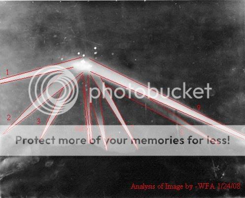
in the picture on page 1 with each bam numbered off (re-posted below) we can get approximate distances for each light. number 9 seems to have another beam behind it, so we will count that one out, but 1 and 9 are strong beams compared to 8 and 6, so 1 and 9, we can assume, are the closest to the object.
With their range of 5.6 miles, you're going to want them to be able to cover a large area yet be able to converge on each other too. Using this we can estimate a rough distance of 10 miles seperating 1 and 9 lights.
4 and 5 would be roughly 12 to 15 miles away, and 6 and 8 slightly further out again due to the loss of light reaching the target in comparison.
Assuming the beams are 5 feet wide at point of origin, we can calculate the overall beam width of the lights, combined with the blast radius example and get an approximation on the size of the craft. Add that to the scale of the ridge too... and we get a much more definite figure for the object.
Taking into consideration that the object is flooded in light and surrounded by smoke, we may never get an exact fix on its size, but we can get a lot closer than before.
First off, here's some data I found regarding the blast radius of HE (high explosive) rounds. I tried to get exact details for anti aircraft types but you'll see from this that it's not easy.
ok, here is a guide to blast radius based on Fragmentation ranges and crate sizes caused by different caliber rounds
Then we have;
Area of Effect
Unless direct hits are sought, HE air-burst is more effective than ground-burst for two reasons: for a given angle of descent there are more useful splinters, particularly at lower angles, and because the splinters strike downwards, instead of horizontal, they reach into holes and hollows. Clearly, the extent of increased effectiveness will depend on the target. Post World War 2 trials found that against dug-in targets proximity (VT) fuzed shells varied from about 1.2 to 2.5 times as effective as ground-burst. However, some data from the war indicated that air-burst could be as much as 10 times as effective as ground-burst.
members.tripod.com...
Which also must take into account Artillery Propellant Formulation and HE characteristics.
Once you've got all that sorted out you can then use this further bit of info to approximate the blast radius of the rounds seen in the photo.
Generally speaking, the blast of the artillery projectile creates a crater (or a shell hole) , if it penetrates the soil, and explodes underneath the surface at an optimum depth. The blast throws up soil high into the air, from which a part scatters around the point of impact, while a part falls back into the crater and to the edges of the crater creating a small embankment surrounding the hole. The maximum depth, where this type of a crater will be formed is roughly 10 times the caliber, which is usually also the radius of the blast.
www.winterwar.com...
The perils of flak;
They exploded in daylight with puffs of black smoke with little red interiors, and made muffled "krumppp" sounds (due to the high levels of noise in the Allied bombers). At night they flashed quickly yellow or red and dissappeared. When one hit close the shards of shrapnel banged through the aircraft and pinged off of more solid members. With a direct hit from an 88 mm or larger shell the aircraft would stagger, sometimes stall, fill with smoke and screaming wounded airmen. Sometimes a wing would fold up and the bomber would go straight down in flames. Other times the entire aircraft would simply vanish in a dirty ball of fire, smoke and bits of plane and man. Many other times the aircraft and men would fly on, riddled with holes but still fighting. Only to have to try to land somewhere without lights, damaged under carriages, missing engines and wounded or dead crew. Often they bombed their targets only to die in a crash landing.
www.constable.ca...
Now, onto the searchlights.
We know they have a max range of 5.6 miles long and a max beam width of 5 feet. How they account for the apparent beam spread is another thing.
in the picture on page 1 with each bam numbered off (re-posted below) we can get approximate distances for each light. number 9 seems to have another beam behind it, so we will count that one out, but 1 and 9 are strong beams compared to 8 and 6, so 1 and 9, we can assume, are the closest to the object.
With their range of 5.6 miles, you're going to want them to be able to cover a large area yet be able to converge on each other too. Using this we can estimate a rough distance of 10 miles seperating 1 and 9 lights.
4 and 5 would be roughly 12 to 15 miles away, and 6 and 8 slightly further out again due to the loss of light reaching the target in comparison.
Assuming the beams are 5 feet wide at point of origin, we can calculate the overall beam width of the lights, combined with the blast radius example and get an approximation on the size of the craft. Add that to the scale of the ridge too... and we get a much more definite figure for the object.
Taking into consideration that the object is flooded in light and surrounded by smoke, we may never get an exact fix on its size, but we can get a lot closer than before.
A book I recently read, 'Flying As It Was', authored by Gerry A. Casey and published by TAB Books, Inc. in 1987, has in it an interesting chapter
relating to his, and his comrades, personal observations of the February, 1942 Los Angeles Air Raid.
Mr. Casey, made his solo flight at age 12, in 1927, and did extensive active flying in the 1930s and 40s. He was hired by the Air Corps Ferrying Command to flight test pilot applicants and happened to be in the Los Angeles area at the time of the 'Air Raid' incident.
Some interesting excerpts from his recollections of that night, follow:
1. He called it 'A phony air raid'.
2. When the aircraft were first spotted in the searchlights, he and his
comrades, agreed they were 'airplanes'.
3. They then all agreed it was a flight of 13 airplanes composed of four
flights of three vee formations--all centered upon a single, huge, four-
engined bomber.
4. He exclaimed, 'Those aren't enemy planes. Look, that bomber is the
Douglas B-19!' He was familiar with the B-19, he welded its landing
gear and some of its engine mounts when he worked at the Douglas
Aircraft plant in Santa Monica.
5. The question that he and the others had was, 'Why are they trying to
shoot down our own planes?'
6. They then noticed that the anti-aircraft shells weren't exploding
anywhere near the planes, but 2,000 to 3,000 feet below them,
eliciting remarks like, 'They aren't trying to shoot 'em down!'
7. After seeing that the planes were in no danger, they could only
conclude that what they were viewing could only 'happen through
some very careful and intelligent orchestration.'
8. They learned that 1,433 rounds of AA shells had been fired and that
two civilians had been killed by falling shrapnel.
9. The next day, Secretary of War, Henry L. Stimson, was quoted as
saying, 'People in Los Angeles were seeing things. There was no
raid, no airplanes--nothing! It must have been a case of mass
hysteria.'
10. These witnesses all agreed that if they had a chance to get to March
Field Airbase in Riverside, California, they'd give great odds that the
fleet of planes, as well as the B-19 bomber, would have been found.
11. The writer still feels the sting as to why he and his comrades, hired as
rational, skilled pilots were subject to insults officially denying any
planes were aloft at that time.
12. The author states that, 'Someone alive knows the story from the
Washington D.C. point of view!'
Hello ALL!
Thank you very much for your thoughtful responses to this topic, and for all of the in-depth research I've read in this thread so far! Extralien especially, you're really thinking about this case's individual aspects, as well as the entire picture as a whole. Thank you all, I really appreciate your thoughts and ideas.
I'm sorry I haven't had more time this weekend, but I've scheduled pretty much all of tonight to work on this thread, and I've got a lot to respond to.
Mobile AA guns, that idea especially throws a few more possible variables into our equation here. I'll be researching this as well, and am looking forward to adding these points of reference to our map. Even mobile platforms must be limited to an approximate location, and there should be a record of each place the guns were fired. Let's find that data and plot it!
Also, thanks for the summary of data on the searchlights thus far. 35 miles seems to be the visual limit for the beams. As for the beam diameter of 5 feet, I'm assuming that means the diameter of the beam as it leaves the light, as opposed to the diameter of the beam once spread? I'll take a second look at all of this too.
Anyway, I'll be back tonight with longer individual replies, and the addition of the new data I've been able to acquire over the weekend. I just wanted to pop in to thank everyone for their hard work and courtesy, and to let you all know that I am reading and following, even though I haven't had time yet to reply.
Be back tonight!
-WFA
This was during WW2 correct? so what makes you think it was aliens exactly? There is proof that the germans were testing anti-gravity aircrafts and
making essentially what we call UFOs today. After WW2 all of the German scientists were brought to America. Many of them were working and
experimenting in New Mexico, hence the Roswell incident in 1947. If you didn't know, Roswell is right outside of the White Sands Missile Range, where
they tested the atom bomb (trinity site) and they still test rockets, missiles, and other things...(cough* UFO's*) . Don't believe me? tell me why
the German Airforce was stationed in New Mexico right next to white sands? (town of Alamagordo).
The Germans were the first to make the UFO's and the US wanted in on the knowledge. They knew what happened in the Battle of LA and you're mostlikley not going to find what you're looking for because what's being hid, is worth hiding when you've got a secret agenda.
Think about Texas and the whole UFO thing, the government is hiding the truth.
Originally posted by leira7
This was during WW2 correct? so what makes you think it was aliens exactly? There is proof that the germans were testing anti-gravity aircrafts and making essentially what we call UFOs today. After WW2 all of the German scientists were brought to America. Many of them were working and experimenting in New Mexico, hence the Roswell incident in 1947. If you didn't know, Roswell is right outside of the White Sands Missile Range, where they tested the atom bomb (trinity site) and they still test rockets, missiles, and other things...(cough* UFO's*) . Don't believe me? tell me why the German Airforce was stationed in New Mexico right next to white sands? (town of Alamagordo).
The Germans were the first to make the UFO's and the US wanted in on the knowledge. They knew what happened in the Battle of LA and you're mostlikley not going to find what you're looking for because what's being hid, is worth hiding when you've got a secret agenda.
Think about Texas and the whole UFO thing, the government is hiding the truth.
I guess you haven't seen footage of these German "flying" saucers in action? If you have you'll know they could not have possibly been involved in the LA incident. I watched an excellent documentary on the History Channel about these German flying saucers, they showed tons of footage and interviewed the scientists involved with the project. Basically the scientists couldn't figure out how to actually make them fly and they lost funding, one scientist said they would need technology off of this world for them saucers to fly.
Originally posted by undermind
Propounded for your consideration: The Battle of Los Angeles was a “blind” anti-aircraft artillary training exercise. Blind means the anti-aircraft batteries were not warned that a training exercise was going to take place. Someone high up wanted to see how they would perform.
A blind test is not out of consideration, but this test in particular does not seem to fit the evidence of this case...
Originally posted by undermind
The targets were towed on long wires by a variety of aircraft, at different speeds, altitudes etc.
Exactly, and we would expect to find debris from the targets and the wires. We find neither. We also have no radar data to support the 'towing aircraft' on this occasion. From this post:
www.abovetopsecret.com...
Extralien cites the CHRONOLOGICAL HISTORY OF THE AIR NATIONAL GUARD AND ITS ANTECEDENTS, 1908 - 2007.
In this catalogue of events, a drill similar to the one you are suggesting was in fact undertaken at Fort MacArthur on the 22nd. There is no similar entry for the 24th-25th, and if this was such a drill, it should have been logged such. No mention of this event was made though, supporting the Air Force's claim (of the time) that their craft were on standby...
Originally posted by undermind
Certainly this raises other questions:
1.There's a risk that the towing planes could be spotted and shot down.
-Possible answer: Part or most pre-issued ammunition is not actual ammunition, but fireworks designed to produce similar burst at set altitude.
-Possible answer: Maybe they just risked it. Remember, anti-aircraft is designed not so much to shoot planes down as to keep them above a certain high altitude where bombing is inaccurate.
Possible answer 1: These were clearly shells, the real deal. Some of them failed to explode in the sky and fell to the streets of Los Angeles below. One of these is photographed in the LA Times.
Possible answer 2: The drill you reference places flak over the ocean, not over the city. The guns were firing in completely the wrong direction, over civilian populated land. I'm thinking that's not a risk one would take, especially with the option of conducting the drill over the ocean where no civilians would potentially be placed in harms way.
Thank you for your thoughts, undermind, but unfortunately I don't believe your theory fits with the evidence found in this case.
reply to post by Leto
Who are you? another disinformist? If it weren't for the german scientists, we would not have made it into space. And you are trusting the History Channel to tell you the truth? Sure you saw the video, but is that all of the video that got filmed? I doubt it. Don't believe what the TV tells you. They (meaning the government) own the media they own the history channel. The tv will only tell you what they want you to believe. The Nazi's got off the ground, I'll bet my last dollar on that!!
Who are you? another disinformist? If it weren't for the german scientists, we would not have made it into space. And you are trusting the History Channel to tell you the truth? Sure you saw the video, but is that all of the video that got filmed? I doubt it. Don't believe what the TV tells you. They (meaning the government) own the media they own the history channel. The tv will only tell you what they want you to believe. The Nazi's got off the ground, I'll bet my last dollar on that!!
Originally posted by LAUGHING-CAT
After looking at the link for the image analysis and then following another link, I came across acouple of eye-witness accounts. One from a person identified as H.C. gave his then location as Adams and crenshaw facing west, the other, identified as Scott Littleton, who gave an address of 2500 Strand. I went to Google maps and their stories both were geographically accurate. The short story being that after I printed out the Google image, I plotted the reported accounts, and the whatever looks to have come in over Hermosa travelling S.W. going just north of Long Beach, then disappearing over Signal Hill. I am looking to find more accounts so as to narrow this down.
Excellent work, and thank you Laughing-Cat!
If it would not be to much to ask, would you mind (and anyone else reading this thread who wants to contribute in this way is also more than welcome!):
Submitting a short EyeWitness Report here in this thread, similar to how you have above. If we can all format each entry, it will be much easier for everyone to reference. For example, the Scott Littleton report...
Eye Witness [W1]: Scott Littleton
Location of Sighting: 2500 Strand
Source of Information: (Insert Link where you found the info)
Link to Map of Location: (Insert Link to google map of the area)
That way, I can take everyones entries and easily plot them on our map as we go forward...
Of note, there is a bibliography already in place, the green numbers found in the original report. If you find a newspaper article that's new, or another internet site you want to add to the initial report, feel free to create a new number for it, and file it that way
For example, I can further reply to undermind's theory above, by citing [N-1] (newspaper article #1), the LA Times report, where he can find the photograph of the shell in question to determine for himself that it wasn't a firework... (Just an example)
Thanks everyone for all of your hard work on this! I've finally got some free time, so I hope I'll be able to respond to everyone and post my new info tonight
Originally posted by Nohup
Nope. That big structure is more likely to be a large oil storage tank. According to the newspaper descriptions, the thing(s) were spotted on radar coming in from the ocean over San Pedro. The way I understand it (please correct me if I'm wrong), the fight path went something like this:

Well, I can't correct you accurately yet Nohup, but sarcasm aside thank you for taking the initial step of posting a possible flight path.
It looks from the evidence like there was more than one object in the sky that night, none of which fell to the ground, several of which may have been fired upon. We also have not yet plotted all of the eyewitness reports on the map, nor cross-indexed their visual sightings to try to sort out the multiple aircraft issue.
I'm just saying it's a little early to draw conclusions, as all the data isn't quite in. But again thanks for the map, and I'll certainly post a flight plan map that reflects the data as soon as I have one. If you beat me to it I'll be more than pleased to duplicate the results independently so we can have a 'sure' thing!
I do happen to agree with you that we don't know what the referenced 'peak' is yet. It could well be an oil tank, like you suggested, or it could be the backside of Griffith Observatory, or any number of other things, including a mountain/hillside. Only through further research will we uncover the truth. I welcome a picture of an oil tank on such a peak, if you have one in mind. Living in the area, if you think you've seen this mountainscape before I'm truly interested in examining your reference. Please show us a comparison picture, if you are able, and thanks for helping us to narrow this down! You've got a good mind, and I appreciate that you are spending time participating in this thread
Originally posted by Steff
I would assume some of those searchlight would come from some of the former NIKE missile sites. There's one that I frequently hike around "dirt" Mullholland. Dirt Mullholland is located west of the 405 driving on Mullholland Drive, a dirt roads veer off, often refered to as dirt Mullholland.
I live in Venice, and my first instict watching th photo was....Thats not over Culver city. Obviously that is Santa Monica mountains in the bg. It seems to me the "valley" searchlights are shooting almost straight up, perhaps a little southbound, which would place the craft more over Bel Air, Pacific Palisades or something.
Check out this site over former NIKE misslile bases.
ed-thelen.org...
Excelent, I will check it out. In fact, if I can find solid data there I'll make plotting this onto the map my first priority after responding to posts this evening.
Also, thank you for your eyewitness testimony of the area(s) in question. Are you able to take pictures of the various mountains from ground level in your area? (I'm not suggesting you just go out and randomly do it LOL) When we have a target location, or if you have a comparison shot you could take, it would be great.
I'm also planning on taking some pics, once I've got some solid target information and can make some educated guesses. I think we're getting there, and I thank you for your help
Originally posted by Extralien
Found something interesting... it's not helpful to the mission here, but it is odd.
...SOURCED MATERIAL...
notice the oddness? Not one mention of the thread related operation...
Odd indeed, and a further record from the US Military on events (or lack thereof) on the night in question. Thank you for adding this.
Originally posted by Extralien
and just as a reminder to WFA, the searchlights have a 5 meter wide beam, with a range of 5 miles approx. and can be seen from over 35 miles away...
so if you're standing 35 miles away and a light is pointing 5 miles up..you'll see the beam.
Thanks for summarizing that, there is a lot of data in this thread and it's easy to get lost in I'll be including a radius circle around Culver City in the next incarnation of the map. Excellent research, and thank you.
Forrest, wow, you've been a member for a long time, and this is your first post? You really should speak more often, I really enjoyed reading your
thoughts!
For the record, I'm a writer (by love not by trade), and may some day write a book on this topic, but I feel also that the truth should be exposed, whether the book I (may or may not) write ever makes a dime. Even if I do write a book about it, ALL of my evidence and research will be posted for free here at ATS (with site owner permission, of course), in the interest of seeing the truth told to those who seek it. I can't speak for this person you're referencing, but it's possible that they share my view. I hope so, it's a huge mystery, and your guest speaker could probably help us a lot. Thank you for trying to locate the person.
Thanks for summarizing this testimony. When looking at the (so far empty on our map) area of the Santa Monica Mountains, I've wondered over the past few days why there were no embankments there. There should have been. Logistically speaking it was a straight flight in from that area to the Western edge of Los Angeles, Beverly Hills, Hollywood, etc.
There doesn't seem to be a good reason for the big gap in our apparent defenses. Mobile AA platforms could well be the answer. I'm going to try to find some solid data on these platforms, and if I can verify anything, I'll include it here.
You're right. We need to get the locations of these events and plot them accordingly. Thanks for highlighting that aspect of the data we already have
Which brings to mind another set of points that would be helpful if plotted on the map, the Radar Arrays, not only the Fixed Postition Arrays we know about, but the possible mobile 'classified at the time' sort you're speaking about. I'll see what I can do research-wise on that front as well.
Excellent, I look forward to your results! If I find anything in my digging, I'll keep you up to date as well
Originally posted by Forrest
...I am currently trying to track down the aforementioned MUFON-GA member to see if he would be willing to contribute to this thread. (But given that I recall him talking about working on a book about this topic, he may not be more forthcoming beyond what I'm about to relate):
For the record, I'm a writer (by love not by trade), and may some day write a book on this topic, but I feel also that the truth should be exposed, whether the book I (may or may not) write ever makes a dime. Even if I do write a book about it, ALL of my evidence and research will be posted for free here at ATS (with site owner permission, of course), in the interest of seeing the truth told to those who seek it. I can't speak for this person you're referencing, but it's possible that they share my view. I hope so, it's a huge mystery, and your guest speaker could probably help us a lot. Thank you for trying to locate the person.
Originally posted by Forrest
... If I remember correctly, he backed his claims via FOIA requests related to the deployment of this heretofore classified system of radar tracking tied to the illuminating units and firing units. Again, my recollection is that these were highly mobile, thus looking at map placements now for emplaced batteries may not yield much in terms of a logistical placement of either the lights in the photo nor the size and placement of the object itself. Rather, a look at the placement of these mobile units would be a better place to investigate.
Thanks for summarizing this testimony. When looking at the (so far empty on our map) area of the Santa Monica Mountains, I've wondered over the past few days why there were no embankments there. There should have been. Logistically speaking it was a straight flight in from that area to the Western edge of Los Angeles, Beverly Hills, Hollywood, etc.
There doesn't seem to be a good reason for the big gap in our apparent defenses. Mobile AA platforms could well be the answer. I'm going to try to find some solid data on these platforms, and if I can verify anything, I'll include it here.
Originally posted by Forrest
There was more physical evidence of the incident beyond the 3 direct and 3 indirect deaths: there was also property damage. Some of that was associated with the 'direct' deaths. Further damage included damaged car and house roofs from falling debris.
You're right. We need to get the locations of these events and plot them accordingly. Thanks for highlighting that aspect of the data we already have
Originally posted by Forrest
Obviously, no craft was actually shot down. After hovering throughout the battle, visual reports have the 'craft' moving south down the coast and then west out to sea, where it was eventually lost to radar contact.
Which brings to mind another set of points that would be helpful if plotted on the map, the Radar Arrays, not only the Fixed Postition Arrays we know about, but the possible mobile 'classified at the time' sort you're speaking about. I'll see what I can do research-wise on that front as well.
Originally posted by Forrest
WFA: I am working on identifying the person I refer to as 'person X' who did a bit of this legwork a few years ago. If I have any more info, I will pass it along. In the meantime, I suggest per what I commented on above, looking into classified radar arrays deployed in LA at that time.
Excellent, I look forward to your results! If I find anything in my digging, I'll keep you up to date as well
Originally posted by Extralien
Hope this is making sense, I've been up all night sorting this little lot out.
It is making sense, and what a phenomenal post. I just gave it a star. Your right on a whole lot of different points here Extralien.
I think you and I are on exactly the same page, that all of this needs to be visually analyzed. I think the first step is getting all of the data onto a map, and we're getting there. I'm going to post an updated map tonight (even if it's 4 in the morning by the time I do it! LOL)
I can't even begin to draw conclusions yet, as much as I want to, but all of your speculation in this post is ringing around in my head, and I'm asking all of the same questions. Thanks for spending all night sorting that out, we're getting closer to our answers every day. In fact, this thread has only been up, what, 3 days now? We've all made amazing progress. Thank you for your personal contributions.
reply to post by kurioz
Thank you for this new source. I tried to find it for sale, but was unable. Can you assist?
According to this google search:
www.google.com...
TAB is a real publisher, and published in '87...
But neither Google, nor Amazon.com:
www.amazon.com...=nb_ss_gw/103-6361796-5110208?url=search-alias%3Daps&field-keywords=%27Flying+As+It+Was%27%2C+authored+by+Gerry+A.+Casey+an d+published+by+TAB+Books%2C+Inc.+in+1987&x=18&y=22
can show me an image of the bookcover or a place this book exists...
I'd like to include this in my source index, and read it for data, could you help us find a copy?
-WFA
Originally posted by leira7
This was during WW2 correct? so what makes you think it was aliens exactly?
Well, it's just a theory, and I've labeled it such. Right now I find it to be the only theory that fits the observable evidence, but if you can find a better one, I'll consider that against the data, and see how it holds up.
The Nazi UFO theory doesn't make sense to me for one reason, and I'll admit, it's not a reason that has anything to do with the Battle of Los Angeles.
Hitler never unleashed A SINGLE ONE of these Nazi UFOs during the entirety of WW2. Never once were they deployed to fight off Allied Aircraft in the skies, or to bomb Allied targets on the ground. In fact, Hitler and the Nazi's lost WW2 without ever using their 'secret UFO weapons' that (if your theory were true) had been battle tested over Allied turf and couldn't be destroyed by Allied fire.
I'm sorry, I just find it hard to believe that the Nazis had such a craft and didn't use it against our fighters. I find it harder to believe than an extraterrestrial craft buzzing a human city. It's counter to logic, and counter to the survival instinct that even people like Hitler surely had.
That's just my take, thanks for your idea. If it does turn out to be a Nazi UFO that was never used in War, I'll gladly apologize. I just don't think such a craft fits the evidence here, a Nazi UFO would have made that fly-by a bombing run, and we'd have found German bomb fragments on the streets of LA...
reply to post by WitnessFromAfar
Steff, I just checked this site out, it looks very well researched. They have a page where they've already mapped these sites, for Google Earth. That page is here:
ed-thelen.org...
It's in the middle, where they discuss US Nike sites...
Does anyone have access to Google Earth? If so, can we get an image out of this data to post here with the locations plotted?
I'm more than willing to replot them on our current map (and WILL certainly plot them regardless on our MASTER MAP, which I'll hopefully be posting later tonight) but if there is already a good plotted map, it would make it a lot easier...
Anyone with Google Earth that can help?
STRIKE THAT!!! LOL check this page out:
ed-thelen.org...
Scroll down a ways until you find the Los Angeles data. Jackpot. There are long and lat coordinates too, so I can plot this against our data on the MASTER MAP I'm creating.
The above page is a link page, with links to all of the locations (by Nike site) mapped by TerraServer, here is the first one, as an example:
terraserver-usa.com...
Consider me plotting Nike base coordinates I'll post again when I've got them up.
Let's all keep digging though, somehow I feel there is more out there still...
Edited for bad grammar
[edit on 29-1-2008 by WitnessFromAfar]
Okay, WOW, that was fun
I've plotted all of the NIKE Missile Base Locations onto a speculative MASTER MAP, together with the locations of the AA Batteries, and the 2 marked locations (so far) of eye-witnesses.
I had to expand the earlier map, to fit the NIKE sites in. Having done this, I will go back and attempt to plot the two missing AA Battery points (Ventura and Santa Barbara) when I have time. I will also include the 'radius' circle patterns in the MASTER MAP's next update. I did manage to verify the Point Vincent location, while searching for the NIKE sites.
Keep in mind that many of the NIKE Sites and AA Battery Sites are the same location. The dots appear next to each other, (right next to each other) but due to the scale of the map, they depict the same physical spots. You can verify visually on the map where these sites overlap.
I think it's important to keep seperate maps for each category we're dealing with here, so I'm going to spend some time tonight working for posterity on each individual map (we've got 5 so far, a BLANK, An AA Battery Map, An Eye-Witness Map, A NIKE Missile Site Map, and a MASTER MAP).
As new data comes in, I will of course update these images. For now, here is the first incarnation of the 'MASTER MAP':
Like the large images before, please click on the pic to launch it in a new window. Then click in the bottom right corner to enlarge the image (within the new window) to full size. For best viewing, save the image and open it in your favorite image program
Source: img213.imageshack.us...
Here is a summary so far of what's on the map:
AA Battery Map Key (Red):
Source: Mapped using a Google Map Compilation, created by WFA
[1] Fort MacArthur Upper Reservation
[2] Fort MacArthur Lower Reservation
[3] Pacific Palasaides Battery
[4] Playa del Rey Battery
[5] El Segundo/Hyperion Battery
[6] Manhattan Beach Battery
[7] Redondo Beach Battery
[8] Rocky Point Battery
[9] Long Point Battery
[10] Bolsa Chica Battery
[11] Costa Mesa Battery
[12] Santa Barbara Battery
[13] Ventura Battery
[14] Point Vincent Battery
[15] Port Hueneme Battery
[16] Oxnard Battery
[17] White Point Battery
[18] Bluff Park/Long Beach Battery
[19] Breakwater Battery
[20] Riverside Battery
Eye-Witness Location(s) Map Key (Blue):
[1] Scott Littleton, 2500 Strand
[2] W.C., Adams & Crenshaw
NIKE Missile Site Map Key (Green):
Source: ed-thelen.org...
Coordinates Mapped Using: www.mapquest.com...
[1] LA-04 Mount Gleason / Palmdale, CA terraserver-usa.com... terraserver-usa.com...
[2] LA-09 Mount Disappointment / Barley Flats, CA terraserver-usa.com... terraserver-usa.com...
[3] LA-14 South El Monte, CA terraserver-usa.com... terraserver-usa.com...
[4] LA-29 Brea / Puente Hills, CA terraserver-usa.com... terraserver-usa.com...
[5] LA-32 Garden Grove, CA terraserver-usa.com... terraserver-usa.com...
[6] LA-40 Long Beach Airport / Lakewood, CA terraserver-usa.com... terraserver-usa.com...
[7] LA-43 Ft. MacArthur (Upper Res. / White Point), CA terraserver-usa.com... terraserver-usa.com...
[8] LA-45DC Ft. MacArthur, CA (MM-__) terraserver-usa.com...
[9] LA-45R Ft. MacArthur / San Pedro Hill AFS, CA (Z-39) terraserver-usa.com...
[10] LA-55 Point Vicente, CA terraserver-usa.com... terraserver-usa.com...
[11] LA-57 Redondo Beach / Torrance, CA terraserver-usa.com... terraserver-usa.com...
[12] LA-70 Hyperion / Playa Del Rey, CA terraserver-usa.com... terraserver-usa.com...
[13] LA-73 Playa Del Rey / LAX, CA terraserver-usa.com... terraserver-usa.com...
[14] LA-78 Malibu, CA terraserver-usa.com... terraserver-usa.com...
[15] LA-88 Chatsworth / Oat Mtn., CA terraserver-usa.com... terraserver-usa.com...
[16] LA-94 Los Pinetos / Newhall, CA terraserver-usa.com... terraserver-usa.com...
[17] LA-96 Van Nuys / Sepulveda, CA terraserver-usa.com... terraserver-usa.com...
[18] LA-98 Magic Mountain / Lang / Saugus, CA terraserver-usa.com... terraserver-usa.com...
Thanks again everyone for your amazing research and well thought out arguments. I can't wait to read the next round of posts!
-WFA
new topics
-
University of Texas Instantly Shuts Down Anti Israel Protests
Education and Media: 27 minutes ago -
Any one suspicious of fever promotions events, major investor Goldman Sachs card only.
The Gray Area: 2 hours ago -
God's Righteousness is Greater than Our Wrath
Religion, Faith, And Theology: 7 hours ago -
Electrical tricks for saving money
Education and Media: 10 hours ago -
VP's Secret Service agent brawls with other agents at Andrews
Mainstream News: 11 hours ago
top topics
-
VP's Secret Service agent brawls with other agents at Andrews
Mainstream News: 11 hours ago, 9 flags -
Cats Used as Live Bait to Train Ferocious Pitbulls in Illegal NYC Dogfighting
Social Issues and Civil Unrest: 15 hours ago, 8 flags -
Nearly 70% Of Americans Want Talks To End War In Ukraine
Political Issues: 12 hours ago, 4 flags -
Electrical tricks for saving money
Education and Media: 10 hours ago, 4 flags -
Sunak spinning the sickness figures
Other Current Events: 12 hours ago, 3 flags -
Late Night with the Devil - a really good unusual modern horror film.
Movies: 14 hours ago, 2 flags -
Any one suspicious of fever promotions events, major investor Goldman Sachs card only.
The Gray Area: 2 hours ago, 2 flags -
The Good News According to Jesus - Episode 1
Religion, Faith, And Theology: 17 hours ago, 1 flags -
God's Righteousness is Greater than Our Wrath
Religion, Faith, And Theology: 7 hours ago, 0 flags -
University of Texas Instantly Shuts Down Anti Israel Protests
Education and Media: 26 minutes ago, 0 flags
active topics
-
God's Righteousness is Greater than Our Wrath
Religion, Faith, And Theology • 25 • : andy06shake -
Russia Ukraine Update Thread - part 3
World War Three • 5730 • : Arbitrageur -
Nearly 70% Of Americans Want Talks To End War In Ukraine
Political Issues • 28 • : andy06shake -
VP's Secret Service agent brawls with other agents at Andrews
Mainstream News • 43 • : Hakaiju -
Everest-sized ‘Devil comet’ Pons-Brooks Visible Now
Space Exploration • 17 • : Compendium -
Nakedeye Mother of Dragons Comet Is Here!
Space Exploration • 5 • : Compendium -
HORRIBLE !! Russian Soldier Drinking Own Urine To Survive In Battle
World War Three • 38 • : BernnieJGato -
15 Unhealthiest Sodas On The Market
Health & Wellness • 43 • : JPRCrastney -
University of Texas Instantly Shuts Down Anti Israel Protests
Education and Media • 0 • : FlyersFan -
Sunak spinning the sickness figures
Other Current Events • 9 • : Ohanka