It looks like you're using an Ad Blocker.
Please white-list or disable AboveTopSecret.com in your ad-blocking tool.
Thank you.
Some features of ATS will be disabled while you continue to use an ad-blocker.

Easter Island Mystery - Worlds largest Glyph seen from Space?
page: 10
share:
If there is one Island surrounded in mystery it would be Easter Island.
Upon viewing Easter Island using common globe viewing programs like Google earth, one can see the devastation and deforastation left behind by the mysterious ancient globe trotters who used the island as a resting place during their voyage, or evacuation of the mainland.
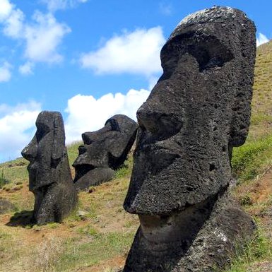
Its isolation in the Pacific is baffling, to think ancient humans traversed that distance let alone the mysterious statues left behind which some were left in mid construction.
The mystery is the Forrest left behind is uncaningly like a mayan glyph or picture, possibly peruvian.
Was this done on purpose or was it a coincidental outcome of deforrestation?
thanks for reading.
[edit on 2-1-2008 by IvanZana]
Upon viewing Easter Island using common globe viewing programs like Google earth, one can see the devastation and deforastation left behind by the mysterious ancient globe trotters who used the island as a resting place during their voyage, or evacuation of the mainland.
Its isolation in the Pacific is baffling, to think ancient humans traversed that distance let alone the mysterious statues left behind which some were left in mid construction.
The mystery is the Forrest left behind is uncaningly like a mayan glyph or picture, possibly peruvian.
Was this done on purpose or was it a coincidental outcome of deforrestation?
thanks for reading.


[edit on 2-1-2008 by IvanZana]
In response to mystery of how humans managed to get that far into the ocean there was an ancient landbridge that connected it to south america. It
also explains the mayan influence observed in many of the statues. Theories are that it was used as a staging point for many ancient explorations to
the other continents by the south americans.
Originally posted by Scalamander
In response to mystery of how humans managed to get that far into the ocean there was an ancient landbridge that connected it to south america. It also explains the mayan influence observed in many of the statues. Theories are that it was used as a staging point for many ancient explorations to the other continents by the south americans.
Awesome info. What do you think of the "glyph"?
As far as the land bridge, i wondered that too. Under the ocean you can see a mountain range or ridge extending all the way with a little bend 2/3rds of the way tp the mysterious Nazca Lines.
Hers a pic I made, the span on the line is 2400miles.

I can help but think about Neal Adams Expanding Earth Theory www.nealadams.com...
heres a vid www.continuitystudios.net...
[edit on 2-1-2008 by IvanZana]
The island was completely deforested when Europeans discovered it in the 1700's so any trees you see there now have been planted since.
It looks like a plantation to me.
It looks like a plantation to me.
I did read that easter island was once inhospitable with little or no game, and scarce vegetation.
It may have once flourished...
But whatver scenario, that is an interesting image nontheless.
[edit on 2-1-2008 by mr-lizard]
It may have once flourished...
But whatver scenario, that is an interesting image nontheless.
[edit on 2-1-2008 by mr-lizard]
It is also along the same latitude line (longitude?) as significant structures in south america, the nazca lines as well as the pyramids of egypt. I
get the feeling this was done intentionally as both the pyramids and nazca lines correspond to astronomical phenomenon.
Easter Island was first inhabited by a small band of Polynesians thousands of years ago by boat. It was not connected to South America by a land
bridge at the time. Remember, the ocean levels rose a significant amount at the earliest 8,000 years ago, and really have not changed much since.
These people were very advanced in ocean travel, capable of traveling hundreds of kilometres on the open ocean. This is similar to how most pacific
islands were inhabited and this shows in the art of the Easter Island people, especially visible in the huge heads. There is also genetic evidence of
their origins.
There is really no mystery to these statues anymore as it is known that they were carved from easily manipulable volcanic rock. Half finished ones have been found in the quarries as well as the tools used to carve them.
They were moved and placed using trees that were once believed to have had made up a significant area of the island. It is believed that this was one of the main factors in the deforestation of the island to what it was like when it was discovered by europeans.
This was not some stepping stone for globe-trotting South American cultures but rather the landing spot for some lucky Polynesians. Inbreeding had pretty much decimated the "native" people by the time the Spanish found it. It was also extremely isolated. Any contact with outside cultures would most likely to have carried over some influence in their culture and art as well as any who visited the island. This was a truly unique culture, even their system of writing is unique to the island.
It is unlikely that Easter Island was intentionally placed on this "line" as placing an entire island in the Pacific would be pretty hard work, that and the Egyptian Pyramids and Nazca lines are connected as there is too much time between these events. Plus, is it so hard to imagine that many different cultures could do great things independently of each other? I mean come on! And would they not choose to make all these look as close to the same as possible? Almost all cultures looked to the heavens for inspiration, even Christianity. It would be safe to assume that there would be some similarity but an intentional, inter-continental development of astronomical inspired structures seems a little far fetched for cultures such as the Egyptians and Amerindians. I will not even go into the fact that the Pyramids of Giza were tombs for uber-powerful kings, that is all together a different topic.
Good stuff, spaceoddity, but I have a few points as well:
I believe the best estimate now is that they got there about AD700-800, though some still say AD300-400 - so at least a thousand years before Europeans arrived anyway.
Advanced in terms of knowledge and technique, but these stone age people didn't have the technology to caulk their boats, meaning they wouldn't have even been water tight! The settlers journey would have been at least 17 days (someone went from Mangareva to Easter using a sailing canoe in 1999 in this amount of time). The thought of spending several weeks out in the middle of the ocean with no navigation and all your worldly belongings (including crops and animals) while constantly bailing out the canoe makes my bowels loosen.
Inbreeding at the end, but that would have been after their culture and population had crashed (probably 200 years before the Europeans got there). For at least 500 years the island would have been thriving enough to support the feeding of all the workers involved in building the statues (ahu) - they have estimated 25% extra food above subsistence would have been required to support this industry.
What did for them was deforestation, which caused a collapse in their environment - soil erosion made farming, what was already crappy land, almost impossible and they would have lost all the native birds - another important source of food. They also couldn't make their boats once the trees were all gone - they had 2 left when Cook arrived.
The mystery of Easter Island is why these people managed to deforest the island, whereas other Polynesian populated islands were still thriving (and still are) when they were "discovered". Jared Diamond goes into great detail about the factors involved in Collapse - How Societies Choose to Fail or Survive if anyone is interested.
[edit on 3/1/08 by FatherLukeDuke]
Originally posted by spacedoddity
Easter Island was first inhabited by a small band of Polynesians thousands of years ago by boat.
I believe the best estimate now is that they got there about AD700-800, though some still say AD300-400 - so at least a thousand years before Europeans arrived anyway.
These people were very advanced in ocean travel, capable of traveling hundreds of kilometres on the open ocean.
Advanced in terms of knowledge and technique, but these stone age people didn't have the technology to caulk their boats, meaning they wouldn't have even been water tight! The settlers journey would have been at least 17 days (someone went from Mangareva to Easter using a sailing canoe in 1999 in this amount of time). The thought of spending several weeks out in the middle of the ocean with no navigation and all your worldly belongings (including crops and animals) while constantly bailing out the canoe makes my bowels loosen.
Inbreeding had pretty much decimated the "native" people by the time the Spanish found it.
Inbreeding at the end, but that would have been after their culture and population had crashed (probably 200 years before the Europeans got there). For at least 500 years the island would have been thriving enough to support the feeding of all the workers involved in building the statues (ahu) - they have estimated 25% extra food above subsistence would have been required to support this industry.
What did for them was deforestation, which caused a collapse in their environment - soil erosion made farming, what was already crappy land, almost impossible and they would have lost all the native birds - another important source of food. They also couldn't make their boats once the trees were all gone - they had 2 left when Cook arrived.
The mystery of Easter Island is why these people managed to deforest the island, whereas other Polynesian populated islands were still thriving (and still are) when they were "discovered". Jared Diamond goes into great detail about the factors involved in Collapse - How Societies Choose to Fail or Survive if anyone is interested.
[edit on 3/1/08 by FatherLukeDuke]
Thanks fatherlukeduke for adding to my information posted. Its good to see somebody else who knows something about this island. When I was a kid was
always very interested in Easter Island's history and had read many books and articles on the topic, but it has been awhile and my knowledge is a
little rusty on the topic.
I remember reading about that guy who did the journey to the island. That is a little crazy for me. It just amazes me what humans were capable with the limited knowledge and technology they had.
I remember reading about that guy who did the journey to the island. That is a little crazy for me. It just amazes me what humans were capable with the limited knowledge and technology they had.
reply to post by spacedoddity
i'm not going to re-hash the same lines as have been re-hashed in the past here concerning the Mystery of Easter Island as we will simply go round in circles with no real outcome.
Suffice to say, the information you provided, while potentially correct (you are obviously well read on the topic and i respect that), does fail to recognise potential land masses which may no longer remain which can explain Easter Island's heritage and exactly what the statues may have been used for.
ANd also, while i know this is off topic, this Pyramids of Giza were NOT tombs of any description.
No bodies have EVER been found in them and the closest thing to tombs found in them could be anything at all. Being tomb shaped doesnt equal a tomb.
But it is very off topic and i dont want to de-rail the thread.
I think the shape of the forrest is due to land boundaries and re-forrestation. Definetly interestingly shaped but no glyph in my opinion
reply to post by IvanZana
The tribal men of Easter island foretold of Obama look at the stone idols they look just like Obama! they worshiped him like they do in the USA, that is so creepy
The tribal men of Easter island foretold of Obama look at the stone idols they look just like Obama! they worshiped him like they do in the USA, that is so creepy
In 1947, Thor Heyerdahl made a raft using raw materials of balsa tree trunks, mangrove wood, and bamboo branches lashed with hemp ropes. He and his
crew managed to sail for 101 days with provisions onboard, over 4,300 miles in the Pacific Ocean.
He proved the polynesians could accomplish sea travel easily, using basic materials and even primitive technologies. As for navigation, we do know the Mayans and Incas were masters of astronomy long before mankind knew the Earth was round.
As Earth is covered by seas, it would not be unnatural to presume that the ancients would not venture out to sea. Mankind had been imbued with curiousity, and knowledge was not aquired from books, but by trials and errors, and was succeeded, was passed down from generations to generations.
They had several centuries of time to trial and test, and eventually with each success, the learning curve became shorter till we could reach the stars within only a few short years. That is our evolution.
As for the glyphs, I know not the answer, nor able to contribute anything, except that if man was responsible for the Nazca lines, then they are are fully capable of anything else, that is, if it was humans who made those lines, which no one has definitieve proof either way.
new topics
-
Weinstein's conviction overturned
Mainstream News: 33 minutes ago -
Supreme Court Oral Arguments 4.25.2024 - Are PRESIDENTS IMMUNE From Later Being Prosecuted.
Above Politics: 2 hours ago -
Krystalnacht on today's most elite Universities?
Social Issues and Civil Unrest: 2 hours ago -
Chris Christie Wishes Death Upon Trump and Ramaswamy
Politicians & People: 2 hours ago -
University of Texas Instantly Shuts Down Anti Israel Protests
Education and Media: 4 hours ago -
Any one suspicious of fever promotions events, major investor Goldman Sachs card only.
The Gray Area: 6 hours ago -
God's Righteousness is Greater than Our Wrath
Religion, Faith, And Theology: 11 hours ago
top topics
-
VP's Secret Service agent brawls with other agents at Andrews
Mainstream News: 15 hours ago, 11 flags -
Nearly 70% Of Americans Want Talks To End War In Ukraine
Political Issues: 16 hours ago, 6 flags -
Krystalnacht on today's most elite Universities?
Social Issues and Civil Unrest: 2 hours ago, 6 flags -
Sunak spinning the sickness figures
Other Current Events: 16 hours ago, 5 flags -
Supreme Court Oral Arguments 4.25.2024 - Are PRESIDENTS IMMUNE From Later Being Prosecuted.
Above Politics: 2 hours ago, 5 flags -
Weinstein's conviction overturned
Mainstream News: 33 minutes ago, 4 flags -
Electrical tricks for saving money
Education and Media: 14 hours ago, 4 flags -
University of Texas Instantly Shuts Down Anti Israel Protests
Education and Media: 4 hours ago, 2 flags -
Any one suspicious of fever promotions events, major investor Goldman Sachs card only.
The Gray Area: 6 hours ago, 2 flags -
Chris Christie Wishes Death Upon Trump and Ramaswamy
Politicians & People: 2 hours ago, 1 flags
active topics
-
Supreme Court Oral Arguments 4.25.2024 - Are PRESIDENTS IMMUNE From Later Being Prosecuted.
Above Politics • 13 • : Vermilion -
University of Texas Instantly Shuts Down Anti Israel Protests
Education and Media • 99 • : xuenchen -
Nearly 70% Of Americans Want Talks To End War In Ukraine
Political Issues • 77 • : Consvoli -
British TV Presenter Refuses To Use Guest's Preferred Pronouns
Education and Media • 159 • : 5thHead -
-@TH3WH17ERABB17- -Q- ---TIME TO SHOW THE WORLD--- -Part- --44--
Dissecting Disinformation • 669 • : Justoneman -
HORRIBLE !! Russian Soldier Drinking Own Urine To Survive In Battle
World War Three • 40 • : Myhandle -
Weinstein's conviction overturned
Mainstream News • 7 • : underpass61 -
President BIDEN Vows to Make Americans Pay More Federal Taxes in 2025 - Political Suicide.
2024 Elections • 144 • : underpass61 -
Sunak spinning the sickness figures
Other Current Events • 19 • : Freeborn -
Candidate TRUMP Now Has Crazy Judge JUAN MERCHAN After Him - The Stormy Daniels Hush-Money Case.
Political Conspiracies • 746 • : matafuchs
0