It looks like you're using an Ad Blocker.
Please white-list or disable AboveTopSecret.com in your ad-blocking tool.
Thank you.
Some features of ATS will be disabled while you continue to use an ad-blocker.

Quake Watch 2008
page: 10share:
www.rgj.com...
I was looking to see if the local paper had any photos of the fissure in Somerset. My mother mentioned it was on the local news yesterday. I know that it's been there since before they built Somerset because my boyfriend worked over there the last two years and told me about it. He said the builders kept dozing dirt and rocks into it, but every morning it'd be visible again.
If this thing's going to go, I wish it would just get it over with. The house creaks all the time and this constant hypervigilance is exhausting. Next time I buy property, I'll either check the fault map out on the internet or have a professional geological report done first.
From what I'm reading, earthquake insurance went up considerably after the 4.7 temblor. I'm glad I bought it Friday. This morning I see the warnings of a possible "big one" have made national news. The suspense is killing me.
I just had an odd thought.
This reminds me of the story of Paracutin..a famous Mexican Volcano, that appeared in a Farmer's cornfield back in the late 40's.
It started with a series of small quakes.
www.paricutin.com...
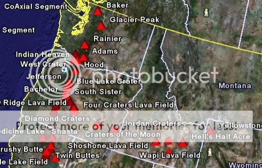
Now, look at this map of potentially active volcanos in the West.
If you were to fill in the blanks, where would you put the dots to complete the picture?
Just a thought..
This reminds me of the story of Paracutin..a famous Mexican Volcano, that appeared in a Farmer's cornfield back in the late 40's.
It started with a series of small quakes.
www.paricutin.com...
Now, look at this map of potentially active volcanos in the West.
If you were to fill in the blanks, where would you put the dots to complete the picture?
Just a thought..
reply to post by spacedoubt
Geez, Space, I haven't slept for 3 days as it is! I know the Long Valley caldera has an alert page on USGS.
Geez, Space, I haven't slept for 3 days as it is! I know the Long Valley caldera has an alert page on USGS.
Originally posted by spacedoubt
www.paricutin.com...
Now, look at this map of potentially active volcanos in the West.
If you were to fill in the blanks, where would you put the dots to complete the picture?
It's weird, I found myself on the wiki page for Paricutin earlier. IIRC it was a volcano typical of that area with cinder cone activity, though I'm not too sure about it. Last year Manchester had a swarm of small quakes in August, though none so big. And I'm no volcanologist.
But as for the map of the volcanoes and the arc from west coast to Yellowstone, this shows it a bit better:
Also, bear in mind that the Cascades are fed by the subducting Juan de Fuca plate, and it gets a bit more complicated the further south till you hit mexico, where it is classic subduction again. But the arc of volcanoes is from a hotspot moving under the crust (or rather the plate moving over the hotspot, same effect though) with Yellowstone at the end. So that chain ends at Yellowstone presently. Of course another could come up, but I only know of 2 sets of hotspot volcanoes, Yellowstone and Hawaii, there are probably more, but I don't remember any others.
At least, I'm pretty sure thats the explanation for that chain toward Yellowstone. Remember Earth is a sphere, the plate would move roughly straight, so it looks curvy, particularly when forced on a flat map.
Eastern Nevada just had a 3.5 quake. Whats up with that? They have been all over the place with a heavy concentration in the Reno area. I think a
large body of Lava is moving under Reno with the heavy activity so concentrated in one spot. Maybe lake Tahoe is going to become a volcano. Maybe it
is an old one? That would explain why it is so deep.
I also seen that they had a 5.8 in Mexico.
I also seen that they had a 5.8 in Mexico.
Reno Nevada 3.0 17:49
I need to tell you something about this one. Our Other Cat began acting really weird, looking at us and meowing, shaking his head. Then running across the room. Thats what he does when he's agitated.
he did this at 17:45..My wife made note of this because she's pretty nervous about the earthquakes.. So his behavior changed 4 minutes before the tremor.
Not really a true scientific experiment, and I didn't Post anything. But I promise I will next round, if it happens again..
Let's see how good he is at this.
i seem unable to find any good web readouts of quakes for Nevada, but this site lists ones in
California, and if you know which one is near you there may be something there to look at. And tell me which one, since I don't know which one is
near you.
And PS, this seems to be what Harmonic tremor might look like, if it is volcanic activity:
Edit: which I'm sure you'd really find not reassuring in the slightest. So contact some actual seismologist or something.
[edit on 28-4-2008 by apex]
And PS, this seems to be what Harmonic tremor might look like, if it is volcanic activity:
Edit: which I'm sure you'd really find not reassuring in the slightest. So contact some actual seismologist or something.
[edit on 28-4-2008 by apex]
I am very concerned for you all, Kat and Doubt, I cannot believe how calmly you are taking this! I would be in another state by now. I do hope you
remain safe, and keep us posted as to futher activity in your locations. I have been watching earthquake and volcano activity closely for a few weeks
now, I had a crazy dream, it had to do with both happening at the same time, and I saw a vocano rise up out of water, after reading Doubt's post
about the 1940's volcano ( I had never heard of this before either) I am wondering if my precog skills aren't honing in on an event to come.
Thank you, SpaceCadet, for your concern. I'm not calm though... we just had a 4.0 at 4:30 a.m. Hell of a way to wake up. After not sleeping more
than a couple restless hours each night for the past three days, I finally went to bed at 8 p.m. last night. The dogs didn't want to come in the
house, so that made me nervous, but we went to bed anyway. Whatever smaller quakes we had during the night, I'd wake up for a minute and think "to
hell with it" and go back to sleep. People in Reno walk around like zombies-- no one's sleeping much, especially those of us living close to the
epicenter. I heard the insurance companies are no longer selling earthquake insurance up here.
And to top it off, our summer arsonist is back in action, setting a brush fire a couple miles from here yesterday afternoon. He seems to prefer this area, NW Reno foothills, as last summer it seemed like most weekends there would be a brush fire up here somewhere. They're not saying serial arsonist yet on the News, but it's pretty obvious to me.
So many people that live up here in the NW foothills, came here after the 7.2 Loma Preita quake in the SF Bay area. So now we're all saying-- one of the reasons we left California was to get away from earthquakes.
reply to post by spacedoubt
Interesting about your cat... I guess your other hasn't returned home yet then. Maybe this is about over now.... I hope. Let us know when he comes home-- we'll take it as a good sign.
My personal earthquake predictor is a headache behind the eyes sort of concentrated in the right temple and it was bad yesterday, getting worse by the time I went to bed. I notice it's better now, which to me is a good sign. I had that headache for four straight days before the last big Seattle quake. I only seem to get them for quakes in the western U.S. I don't know why, but I've learned to pay attention as I don't get headaches as a rule. Sleeplessness is another signal for me.
Edit to add: Doubt, you might try giving your cat Bach's Rescue Remedy drops-- it calms them down. Four drops in water or milk. I've been putting them in my dogs' water bowl as well lately. I get mine at Everlasting Health downtown. Five Flower drops are the same thing and somewhat less expensive. I use them myself.
[edit on 4/28/08 by kattraxx]
quake.wr.usgs.gov...
Upgraded to a 4.2. What I find interesting on the current recent activity map of California and Nevada is the increase in magnitude of the quakes south of Reno and heading east towards the Wells area.
And now USGS has upgraded the 4.7 a couple days ago to a 5.0.
[edit on 4/28/08 by kattraxx]
Upgraded to a 4.2. What I find interesting on the current recent activity map of California and Nevada is the increase in magnitude of the quakes south of Reno and heading east towards the Wells area.
And now USGS has upgraded the 4.7 a couple days ago to a 5.0.
[edit on 4/28/08 by kattraxx]
reply to post by kattraxx
Thats weird, I wonder if a barometer could show any movements any way before and after the quake, Or maybe its radio frequency's in the very low range like the annoying Taos, New Mexico humming noise. I would bet on the low frequency vibrations. See if you can find any ham radio guys in the area to listen for something on a scanner or try to get in touch with Art Bell and he can listen for them. Just a thought.
Now that I have done more thinking, Its probably in the classified Navy frequency's so they would not be able to listen for them anyway. It wouldn't hurt to ask Art about that possibility though.
[edit on 28-4-2008 by Sky watcher]
Magnitude 6.0 - SOUTH SANDWICH ISLANDS REGION
2008 April 28 15:58:02 UTC
Depth 97km
You guys sure are making me glad I'm not in an earthquake prone zone, though it does feel a bit silly to be sitting here discussing it from here.
[edit on 28-4-2008 by apex]
2008 April 28 15:58:02 UTC
Depth 97km
You guys sure are making me glad I'm not in an earthquake prone zone, though it does feel a bit silly to be sitting here discussing it from here.
[edit on 28-4-2008 by apex]
This one is within the last hour and reviewed, but someone please update any changes if you spot any before I get back
Magnitude 6.0 SOUTH SANDWICH ISLANDS REGION
Monday, April 28, 2008 at 15:57:55 UTC
Depth 35 km (21.7 miles)
Seems you guys in Nevada were far enough from this one
Magnitude 6.0 SOUTH SANDWICH ISLANDS REGION
Monday, April 28, 2008 at 15:57:55 UTC
Depth 35 km (21.7 miles)
Seems you guys in Nevada were far enough from this one
MAP 6.4 2008/Text Red04/28 18:33:29 -20.174 168.802 3.6 LOYALTY ISLANDS
reply to post by michigangirl
Follow the link, rather than using the table, as a guideline
to get it like this:
Magnitude 6.4 - LOYALTY ISLANDS
2008 April 28 18:33:28 UTC
Depth 3.6km
use this code:
[url=http://earthquake.usgs.gov/eqcenter/recenteqsww/Quakes/us2008rjbe.php]Magnitude 6.4 - LOYALTY ISLANDS
2008 April 28 18:33:28 UTC
Depth 3.6km[/url]
3.1 in northern Oregon.
earthquake.usgs.gov...
Look at this map below and tell me if it don't look like Lava is trying to find its way to Yellowstone through a new route.
earthquake.usgs.gov...
Look at this map below and tell me if it don't look like Lava is trying to find its way to Yellowstone through a new route.
reply to post by Sky watcher
Sky, I'm sleep-deprived and all but I can't find the map you're referring to and I'd like to see this... Are you speaking about the "trail" of quakes across Nevada?
quake.wr.usgs.gov... Animation of quakes in the past seven days. Click on Start Animation.
[edit on 4/28/08 by kattraxx]
Sky, I'm sleep-deprived and all but I can't find the map you're referring to and I'd like to see this... Are you speaking about the "trail" of quakes across Nevada?
quake.wr.usgs.gov... Animation of quakes in the past seven days. Click on Start Animation.
[edit on 4/28/08 by kattraxx]
reply to post by kattraxx
Ah my pain meds are making me dumb. I forgot that Yellowstone was its own hot spot with lava coming from deep below. Thats a pretty cool animation, Thanks.
Why don't you pitch a tent in the yard with the dogs and get some sleep that way? Odds are the quake will not bring down the house in the time it would take for you to get out.
new topics
-
God's Righteousness is Greater than Our Wrath
Religion, Faith, And Theology: 2 hours ago -
Electrical tricks for saving money
Education and Media: 5 hours ago -
VP's Secret Service agent brawls with other agents at Andrews
Mainstream News: 6 hours ago -
Sunak spinning the sickness figures
Other Current Events: 7 hours ago -
Nearly 70% Of Americans Want Talks To End War In Ukraine
Political Issues: 7 hours ago -
Late Night with the Devil - a really good unusual modern horror film.
Movies: 9 hours ago -
Cats Used as Live Bait to Train Ferocious Pitbulls in Illegal NYC Dogfighting
Social Issues and Civil Unrest: 10 hours ago
top topics
-
VP's Secret Service agent brawls with other agents at Andrews
Mainstream News: 6 hours ago, 9 flags -
Florida man's trip overseas ends in shock over $143,000 T-Mobile phone bill
Social Issues and Civil Unrest: 17 hours ago, 8 flags -
Cats Used as Live Bait to Train Ferocious Pitbulls in Illegal NYC Dogfighting
Social Issues and Civil Unrest: 10 hours ago, 8 flags -
Electrical tricks for saving money
Education and Media: 5 hours ago, 4 flags -
Bobiverse
Fantasy & Science Fiction: 17 hours ago, 3 flags -
HORRIBLE !! Russian Soldier Drinking Own Urine To Survive In Battle
World War Three: 14 hours ago, 3 flags -
Nearly 70% Of Americans Want Talks To End War In Ukraine
Political Issues: 7 hours ago, 3 flags -
Sunak spinning the sickness figures
Other Current Events: 7 hours ago, 3 flags -
Late Night with the Devil - a really good unusual modern horror film.
Movies: 9 hours ago, 2 flags -
The Good News According to Jesus - Episode 1
Religion, Faith, And Theology: 12 hours ago, 1 flags
active topics
-
Cats Used as Live Bait to Train Ferocious Pitbulls in Illegal NYC Dogfighting
Social Issues and Civil Unrest • 20 • : Asher47 -
Nearly 70% Of Americans Want Talks To End War In Ukraine
Political Issues • 12 • : Asher47 -
VP's Secret Service agent brawls with other agents at Andrews
Mainstream News • 39 • : Asher47 -
Electrical tricks for saving money
Education and Media • 4 • : Lumenari -
New whistleblower Jason Sands speaks on Twitter Spaces last night.
Aliens and UFOs • 54 • : Ophiuchus1 -
DONALD J. TRUMP - 2024 Candidate for President - His Communications to Americans and the World.
2024 Elections • 514 • : WeMustCare -
The Acronym Game .. Pt.3
General Chit Chat • 7744 • : bally001 -
Truth Social goes public, be careful not to lose your money
Mainstream News • 128 • : Astyanax -
Sunak spinning the sickness figures
Other Current Events • 5 • : glen200376 -
SETI chief says US has no evidence for alien technology. 'And we never have'
Aliens and UFOs • 44 • : MikeDeGrasseTyson