It looks like you're using an Ad Blocker.
Please white-list or disable AboveTopSecret.com in your ad-blocking tool.
Thank you.
Some features of ATS will be disabled while you continue to use an ad-blocker.

Alien City On Mars? Check This Out!
page: 16share:
Originally posted by rocksarerocks
I'm sorry but there has been absolutely zero proof presented here than anything exists in that original photo besides artifacts of JPEG compression, and THAT has been proven over and over again.
Put some coolant in your radiator, rocks! NO ONE here has said anything about PROOF of anything, at least not so far! We are all SEEKING proof. We haven't got it yet. We're still in the discussion stage and may take a few years more for incontrovertible evidence/proof of any alien civilization on Mars.
Have a nice day!
Cheers!
And hey! Why on Earth do you name the first pic above, MOS EISLEY SPACEPORT? Why of all things 'Mos Eisley'? Why not Elvis Presley?!!
Mos Eisley is a desert city from the film, STAR WARS. Here's the scene from the film that it reminded me of:
And the original screen for the scene, painted by Ralph McQuarrie:
OK, show us one of those satellite photos from Google Earth that you keep talking about that shows number plates.
Originally posted by mikesingh
If I can see my number plates through Google etc from a satellite 400 Km in space, then why these badly 'pixelated', 'mapped over' images from Mars? Why can't I get to see that number plate on Mars too? (Just a figure of speech! )
And I wonder why you are still ignoring those photos with a 25cm/pixel resolution...
Pretty unusual shape for anything, that is one of the most useless photos I have seen.
Having said that take a peek at this image of Mars South Pole. The area has been enlarged by Liz Edwards of Iwonder Pruductions. Pretty unusual shape for a natural rock formation in the middle, what?

Courtesy: Liz Edwards
reply to post by undo
It's an optical illusion.
That image is 4710 pixels wide and, according to World Wind, that area measuers around 235km, making it a 69m/pixel image.
And, apparently, we get once again those "artifacts" of mapping a 2D image over a 3D model.
It's an optical illusion.
That image is 4710 pixels wide and, according to World Wind, that area measuers around 235km, making it a 69m/pixel image.
And, apparently, we get once again those "artifacts" of mapping a 2D image over a 3D model.
Originally posted by ArMaP
It's an optical illusion.
That image is 4710 pixels wide and, according to World Wind, that area measuers around 235km, making it a 69m/pixel image.
And, apparently, we get once again those "artifacts" of mapping a 2D image over a 3D model.
That's a 3d model?
And what artifacts are you referring to? the ones with rounded corners?
reply to post by undo
Yes, that is a 3D model, if it was just a normal photo it would look like this

instead of looking like this

The artifacts are bad joining between photos that become part of the relief,


stretched pixels

and other things like those.
PS: I forgot to post the image that shows my measurements.

Edit: this page shows that the resolution is very low and that I was wrong in my calculations.
[edit on 15/11/2007 by ArMaP]
Another edit to say that your "Mos Eisley" would be on this area.

[edit on 15/11/2007 by ArMaP]
Edit: this page shows that the resolution is very low and that I was wrong in my calculations.
Wrong in which calculations?
reply to post by undo
My calculations about the resolution, but now that I looked at it again I think that I was right.
Anyway, it is already 1 AM here in Portugal, so I think it's best to leave any calculations for tomorrow.
My calculations about the resolution, but now that I looked at it again I think that I was right.
Anyway, it is already 1 AM here in Portugal, so I think it's best to leave any calculations for tomorrow.
This is what the jpl site says about the image
photojournal.jpl.nasa.gov...
So what you are saying is that this explanation is saying it is 3-d ? And if so, does that mean the moment they paste the images over 3-d models that the images are no longer of any value other than to display height/depth? And if they were simply to show height/depth, wouldn't they use the standard mapping procedure for that instead of this one? If there were a building in an image such as this, would we have to automatically assume it's just an artifact because it's real photos pasted on 3-d model? What about the real photos? They are useless?
Original Caption Released with Image:
An oblique, color image of central Valles Marineris, Mars showing relief of Ophir and Candor Chasmata; view toward east. The photograph is a composite of Viking high-resolution images in black and white and low-resolution images in color. Ophir Chasma on the north (left side) is approximately 300 km across and as deep as 10 km. The connected chasma or valleys of Valles Marineris may have formed from a combination of erosional collapse and structural activity. Tongues of interior layered deposits on the floor of the chasmata can be observed as well as young landslide material along the base of Ophir Chasma's north wall.
photojournal.jpl.nasa.gov...
So what you are saying is that this explanation is saying it is 3-d ? And if so, does that mean the moment they paste the images over 3-d models that the images are no longer of any value other than to display height/depth? And if they were simply to show height/depth, wouldn't they use the standard mapping procedure for that instead of this one? If there were a building in an image such as this, would we have to automatically assume it's just an artifact because it's real photos pasted on 3-d model? What about the real photos? They are useless?
Originally posted by undo
So what you are saying is that this explanation is saying it is 3-d ? And if so, does that mean the moment they paste the images over 3-d models that the images are no longer of any value other than to display height/depth? And if they were simply to show height/depth, wouldn't they use the standard mapping procedure for that instead of this one? If there were a building in an image such as this, would we have to automatically assume it's just an artifact because it's real photos pasted on 3-d model? What about the real photos? They are useless?
That's what I've been trying to get an answer to since the age of the dinosaurs, or at least a dozen pages back! Guess I'll have to wait till the sun becomes a Red Giant to get a proper answer!!
Cheers!
Originally posted by mikesingh
That's what I've been trying to get an answer to since the age of the dinosaurs, or at least a dozen pages back! Guess I'll have to wait till the sun becomes a Red Giant to get a proper answer!!
Cheers!
the artifact clause was called in to the effort. that seems a bit desperate, as armap is usually not quite as stubborn about such things. if he doesn't have a reasonable explanation, he rarely goes for any excuse that'll work, and tends to just not respond at all. this is a first for him, i do believe. must've struck a nerve.
Originally posted by ArMaP
The artifacts are bad joining between photos that become part of the relief,
stretched pixels.
ArMaP, do you really believe yourself when you say that the 'furrows' in the pic below are due to bad joining between photos? Can you replicate this so we know this CAN happen? Notice there is already a joint between the two images which can be discerned clearly BELOW the 'tracks' or 'furrows'.
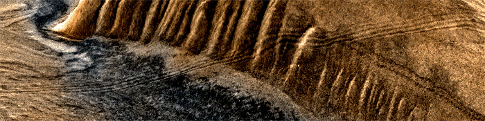
So, if you say that it is due to 'bad joining', then...
> NASA has awfully incompetent dudes on board. Is that all they can get in the whole of the US of A / Europe? These guys can't join two pics together! Is this the end result of billion dollar probes?
> So why haven't these goofs been sacked as yet? Are NASA's or ESA's qualitative requirements being met by this sub standard exhibition of incompetence?
I don't believe it. Period!
Cheers!
[edit on 16-11-2007 by mikesingh]
No, what I was saying is that, to me, everything shows that image as a 3D computer generated image made with the Viking photos.
Originally posted by undo
So what you are saying is that this explanation is saying it is 3-d ?
No, the images show the same things but mapped over the height data. The original images do not display the height/depth, if that was the case there would be no need of 3D images
And if so, does that mean the moment they paste the images over 3-d models that the images are no longer of any value other than to display height/depth?
And if they were simply to show height/depth, wouldn't they use the standard mapping procedure for that instead of this one?
Sorry, I don't understand it, what do you mean by "standard mapping procedure"?
If a building were visible in a 3D model that would be the result of the height data, not of the original image, you can map a photo of a building over a flat 3D model or map a photo of a flat surface over a building on a 3D model.
If there were a building in an image such as this, would we have to automatically assume it's just an artifact because it's real photos pasted on 3-d model?
The problem with this type of 3D models with images mapped over them is that they may create their own artifacts that may add to the original image artifacts (if any), making it less representative of the real target of the photo in a 2D way while making it more representative of the target in a 3D way.
Of course not, the original photos are the real photos, so they are the most important data for those that are looking for visible clues of something.
What about the real photos? They are useless?
Of course not, the original photos are the real photos, so they are the most important data for those that are looking for visible clues of something.
So if the original photos are available and show the same anomalies, what then? Will we assume they are artifacts?
Here are the anomalies, relabelled as "artifacts"
whatcha think? are they artifacts? what condition would cause these artifacts? they can't be labelled as pixellizations because they don't
fit the description. they aren't "blocks" of solid color and they have rounded corners
Hello Mikesingh and undo,
I would like to get into the Mars-subject a bit more so that I can talk about it and maybe even help in finding anomalies.
As a beginner on the subject, what websites would you suggest I read first?
I would like to get into the Mars-subject a bit more so that I can talk about it and maybe even help in finding anomalies.
As a beginner on the subject, what websites would you suggest I read first?
Hello again everyone, I posted this pic before but I'm going to post it again. Only because after much googling....this anomoly might possibly
resemble a Sumerian monument more than it does Egyptian. thoughts? Do you think it was possibly photoshopped? FYI, this was right out off the ESA
sight. I'm by no means an expert, but the link is below.

www.esa.int...
Undo - Nice Pics, good find!
MikeSingh - still - good work as usual...
Armap no snow? ever? you need to get into a snowball fight! come to Wisconsin!
thanks guys/gals
www.esa.int...
Undo - Nice Pics, good find!
MikeSingh - still - good work as usual...
Armap no snow? ever? you need to get into a snowball fight! come to Wisconsin!
thanks guys/gals
Originally posted by Skyfloating
Hello Mikesingh and undo,
I would like to get into the Mars-subject a bit more so that I can talk about it and maybe even help in finding anomalies.
As a beginner on the subject, what websites would you suggest I read first?
I'd start with nasa images, and the companies associated with nasa (like jpl, for example), and work from there, primarily because you don't want your observations to be pre-determined. you want it to be unbiased, and then work from that position. if what you're seeing doesn't match what they are saying you should see, you must determine which is the most likely, i suppose.
Tube rings
from "the roof" (full view please thestargates.com... )
which is from:
PIA00416
www.thestargates.com...
that can be substantiated at JPL PHOTOJOURNAL
photojournal.jpl.nasa.gov...
other interesting areas in the vicinity are (full view please thestargates.com... ):
[edit on 16-11-2007 by undo]
from "the roof" (full view please thestargates.com... )
which is from:
PIA00416
www.thestargates.com...
that can be substantiated at JPL PHOTOJOURNAL
photojournal.jpl.nasa.gov...
other interesting areas in the vicinity are (full view please thestargates.com... ):
[edit on 16-11-2007 by undo]
Originally posted by ArMaP
Originally posted by undo
So what you are saying is that this explanation is saying it is 3-d ?
No, what I was saying is that, to me, everything shows that image as a 3D computer generated image made with the Viking photos...
...And that the picture is titled "Oblique View with Altimetry of Valles Marineris".
Speaking of Mars altimetry: Here's a fun site to play with...
jmars.asu.edu...
Interactive HiRISE atlas...
marsoweb.nas.nasa.gov...
[edit on 16-11-2007 by IAttackPeople]
[edit on 16-11-2007 by IAttackPeople]
new topics
-
VP's Secret Service agent brawls with other agents at Andrews
Mainstream News: 14 minutes ago -
Sunak spinning the sickness figures
Other Current Events: 55 minutes ago -
Nearly 70% Of Americans Want Talks To End War In Ukraine
Political Issues: 1 hours ago -
Late Night with the Devil - a really good unusual modern horror film.
Movies: 2 hours ago -
Cats Used as Live Bait to Train Ferocious Pitbulls in Illegal NYC Dogfighting
Social Issues and Civil Unrest: 4 hours ago -
The Good News According to Jesus - Episode 1
Religion, Faith, And Theology: 6 hours ago -
HORRIBLE !! Russian Soldier Drinking Own Urine To Survive In Battle
World War Three: 8 hours ago -
Bobiverse
Fantasy & Science Fiction: 11 hours ago -
Florida man's trip overseas ends in shock over $143,000 T-Mobile phone bill
Social Issues and Civil Unrest: 11 hours ago
top topics
-
Florida man's trip overseas ends in shock over $143,000 T-Mobile phone bill
Social Issues and Civil Unrest: 11 hours ago, 8 flags -
SETI chief says US has no evidence for alien technology. 'And we never have'
Aliens and UFOs: 15 hours ago, 7 flags -
Cats Used as Live Bait to Train Ferocious Pitbulls in Illegal NYC Dogfighting
Social Issues and Civil Unrest: 4 hours ago, 7 flags -
This is our Story
General Entertainment: 17 hours ago, 4 flags -
Former Labour minister Frank Field dies aged 81
People: 13 hours ago, 4 flags -
Bobiverse
Fantasy & Science Fiction: 11 hours ago, 3 flags -
HORRIBLE !! Russian Soldier Drinking Own Urine To Survive In Battle
World War Three: 8 hours ago, 2 flags -
Nearly 70% Of Americans Want Talks To End War In Ukraine
Political Issues: 1 hours ago, 2 flags -
Late Night with the Devil - a really good unusual modern horror film.
Movies: 2 hours ago, 2 flags -
VP's Secret Service agent brawls with other agents at Andrews
Mainstream News: 14 minutes ago, 1 flags
active topics
-
VP's Secret Service agent brawls with other agents at Andrews
Mainstream News • 3 • : matafuchs -
President BIDEN Vows to Make Americans Pay More Federal Taxes in 2025 - Political Suicide.
2024 Elections • 119 • : Zanti Misfit -
Truth Social goes public, be careful not to lose your money
Mainstream News • 126 • : Zanti Misfit -
Nearly 70% Of Americans Want Talks To End War In Ukraine
Political Issues • 6 • : budzprime69 -
HORRIBLE !! Russian Soldier Drinking Own Urine To Survive In Battle
World War Three • 25 • : Freeborn -
Definitive 9.11 Pentagon EVIDENCE.
9/11 Conspiracies • 422 • : Zanti Misfit -
Breaking Baltimore, ship brings down bridge, mass casualties
Other Current Events • 482 • : IndieA -
How ageing is" immune deficiency"
Medical Issues & Conspiracies • 30 • : annonentity -
Remember These Attacks When President Trump 2.0 Retribution-Justice Commences.
2024 Elections • 55 • : Zanti Misfit -
SETI chief says US has no evidence for alien technology. 'And we never have'
Aliens and UFOs • 36 • : anthelion