It looks like you're using an Ad Blocker.
Please white-list or disable AboveTopSecret.com in your ad-blocking tool.
Thank you.
Some features of ATS will be disabled while you continue to use an ad-blocker.

The Lost Flight -- Who Knew What and When About Flight AA77 On 9/11?
page: 11
share:
Sami Yli-Karjanmaa is a great Pentagon researcher out of Holland.
His paper on the ASCE Building Performance report is excellent.
read here.
This new short he released exposes more fatal contradictions in the official Pentagon story in the sense that the 9/11 commission completely changed their story about when the FAA knew where "flight 77" was before the attack and after it disappeared at 8:56
The Lost Flight -- Who Knew What and When About Flight AA77 On 9/11?
Sami refrains from theorizing and merely shows enough footage to prove this blatant and pathetic glaring contradiction but of course the implications of this are that the final story is simply a fabrication that was molded to suit their needs.
One thing for sure is that both accounts can't be true.
They really ended up throwing Mineta under the bus with this one.
They did the SAME THING with the flight path too.
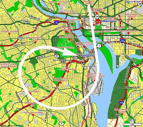
Here is the "down river approach" flight path that was originally reported and believed for years to be accurate as it was the only flight path that was described.
From Mineta's testimony:
Mineta does not mince words in 2002. The flight path he is describing allegedly based off radar is quite clear.
However the NTSB reported something entirely different in 2006!
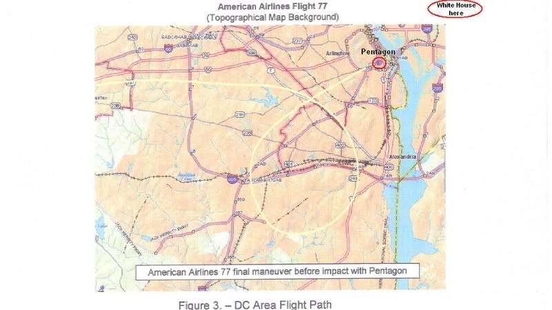
So according to the NTSB.....the FDR says that flight 77 was not ever going "downriver" at all and the entire "loop" was completely to the west of the Pentagon so the plane never "over-passed" the Pentagon.
So who is lying? The NTSB or Mineta? The 9/11 Comission or Mineta? Mineta is being way too detailed to have simply made a mistake. Particularly since he is not the only one whose story doesn't match the NTSB flight path.
So the story completely changed in regards to WHEN they detected the plane and exactly WHERE the plane flew throwing Mineta under the bus and any others who relayed the first versions of these stories.
Yet the media is silent.
His paper on the ASCE Building Performance report is excellent.
read here.
This new short he released exposes more fatal contradictions in the official Pentagon story in the sense that the 9/11 commission completely changed their story about when the FAA knew where "flight 77" was before the attack and after it disappeared at 8:56
The Lost Flight -- Who Knew What and When About Flight AA77 On 9/11?
Sami refrains from theorizing and merely shows enough footage to prove this blatant and pathetic glaring contradiction but of course the implications of this are that the final story is simply a fabrication that was molded to suit their needs.
One thing for sure is that both accounts can't be true.
They really ended up throwing Mineta under the bus with this one.
They did the SAME THING with the flight path too.
Here is the "down river approach" flight path that was originally reported and believed for years to be accurate as it was the only flight path that was described.
From Mineta's testimony:
from 2002 NBC News interview with Mineta
MINETA: So then someone came in, the same person came in and said, "Mr. Vice President, it -- the plane's 30-miles out." So I said, "Monte, can you see it, and where is it in relationship to the ground?"
He said, "Well, that's difficult to really determine. I would guess it's somewhere between Great Falls and National Airport, coming what they call the DRA, the down river approach."
And so then the person came in and said, "Mr. Vice President, the plane's ten-miles out," and so I said, "Monte, where is it?" and he said, "Well, I'm not really sure but I'd be guessing somewhere maybe between the USA Today building and, and National Airport."
"HAGER: Now coming over to the White House and you're down there in the bunker, and that third unidentified blip is coming down the Potomac.
For one thing, had you thought about the possibility that it might be -- I mean you're at the White House. That's the center where everything is going on. Is that something that would have gone through your mind?
MINETA:Well, the question was where is it coming. And so as I was asking Monte, it was following pretty much the DRA, the down river approach, and it had not crossed over towards the White House or towards the Capitol. It was staying on its line towards what would normally be the traffic pattern into National Airport.
And in fact, later on, in looking at the radar track, the plane had actually over-passed the Pentagon, then turned around and then came back into it, and it never took a wide sweep to cross over to the east side of the White House.
MINETA:Oh, absolutely, it's something like that, but at least at the time the track of the radar was following what would be considered the down-river approach and it never came over to cross the east side of the Potomac River and it just followed the river all the way in.
Mineta does not mince words in 2002. The flight path he is describing allegedly based off radar is quite clear.
However the NTSB reported something entirely different in 2006!
So according to the NTSB.....the FDR says that flight 77 was not ever going "downriver" at all and the entire "loop" was completely to the west of the Pentagon so the plane never "over-passed" the Pentagon.
So who is lying? The NTSB or Mineta? The 9/11 Comission or Mineta? Mineta is being way too detailed to have simply made a mistake. Particularly since he is not the only one whose story doesn't match the NTSB flight path.
So the story completely changed in regards to WHEN they detected the plane and exactly WHERE the plane flew throwing Mineta under the bus and any others who relayed the first versions of these stories.
Yet the media is silent.
Pertial reply - to the loop 'discrepancy' half:
Again with the accusation there was ever more than error behind Koeppel’s map.
Old 270 loop explained
Regarding the term 'down-river approach.'
Mineta said: "I would guess it's somewhere between Great Falls and National Airport, coming what they call the DRA, the down river approach."
Map of Great Falls, VA
Take a look - zoom out and see its relation to the Potomac, Dulles, Reagan National (right behind the Pentagon) and Koeppel’s erred map. It would not be set to swoop down over DC from the northeast in Mineta's story. It doesn't exactly fit the radar loop either, but seems vaguely in-between the two.
Also note in the map linked above, that in general the Potomac flows from west to east. The plane (officially) came in west to east, somewhat along but well south of the river.
So Mineta says Monte says " I'd be guessing somewhere maybe between the USA Today building and, and National Airport."
And Mineta elaborates “Well, the question was where is it coming. And so as I was asking Monte, it was following pretty much the DRA, the down river approach, and it had not crossed over towards the White House or towards the Capitol. It was staying on its line towards what would normally be the traffic pattern into National Airport. […] The track of the radar was following what would be considered the down-river approach and it never came over to cross the east side of the Potomac River and it just followed the river all the way in.”
West to east, past a point between Dulles/Great Falls and Reagan/Pentagon, never crossing TO DC ‘side’. Cheney’s description too of the loop before impact could fit this map as well as it does Koeppel’s, which shows it crossing down only the mouth of the river ALONG the edge of the DC ‘side.’
So who’s actually lying? Anyone?
[edit on 29-10-2007 by Caustic Logic]
[edit on 29-10-2007 by Caustic Logic]
As usual you are wrong.
The 2006 NTSB flight path can NOT in any circumstances be described as "what would normally be the traffic pattern into National Airport" or the down river approach that Mineta was describing.
Regardless of how much you spin Mineta and Belger's flight path description I noticed how you ignored Sami's presentation.
Still working on a spin for that one too or is it sufficiently LIHOP enough that you can back it?
The NTSB flight path will be proven a fraud once and for all soon enough.
originally posted by Caustic Logic
So according to the NTSB.....the FDR says that flight 77 was not ever going "downriver" at all and the entire "loop" was completely to the west of the Pentagon so the plane never "over-passed" the Pentagon.
Not only the NTSB, but also the Air Force's 84th RADES.
Link
Originally posted by Craig Ranke CIT
As usual you are wrong.
The 2006 NTSB flight path can NOT in any circumstances be described as "what would normally be the traffic pattern into National Airport" or the down river approach that Mineta was describing.
Well I never said for sure this was the 'normal pattern,' as I don't know how to find that out. But you state flatly, it seems, all traffic to Reagan comes in south down that narrow stretch of river. Can you illustrate that this is the one and only normal approach? Or is just something that 'everyone knows?' Where in that supposed Cheney-Mineta supporting map is the lane betwwn Reagan and Great Falls?
I'll do a graphic...
Regardless of how much you spin Mineta and Belger's flight path description I noticed how you ignored Sami's presentation.
For the time. He's a smart-sounding guy, but a fraudster. I'll check it out soon.
Still working on a spin for that one too or is it sufficiently LIHOP enough that you can back it?
Yes and don't know.
Originally posted by Boone 870
originally posted by Caustic Logic
So according to the NTSB.....the FDR says that flight 77 was not ever going "downriver" at all and the entire "loop" was completely to the west of the Pentagon so the plane never "over-passed" the Pentagon.
Not only the NTSB, but also the Air Force's 84th RADES.
Link
[sarcasm]No Boone, this is the 9/11 Commission's loop. They're the least trusted by truthers, so they must've invented it. Better, yet, Cheney's loop. Or is his Koeppel's? Anyway, someone shady invented something that was then copied-and-pasted into FAA radar records, RADES analysis, and the FDR.
Didn't you see where the wrong guy's wrong map said to be official and the same as
Mineta's is different from this one? So someone's lying... and this proves something sinister. [/sarcasm]
reply to post by Caustic Logic
I know what you mean CL. Those conspirators were very very busy planting all the fake evidence.
I know what you mean CL. Those conspirators were very very busy planting all the fake evidence.
reply to post by Caustic Logic
If you aren't aware that there is a strict flight pattern for Reagan traffic due to the sensitivity of the area etc then I simply don't know what to say to help you.
Stop making authoritative statements when you have no clue what you are talking about.
Monty Belger was NOT describing the NTSB flight path to Mineta and when you analyze all of the statements made by the C-130 pilot you will find that he also fatally contradicts the NTSB flight path.
Good news......we have compiled this data for you in a brand new thread available here.
Chew on that for a while and see if you have anything intelligent to add.
But we aren't done.
As I keep promising we will eventually provide testimony that proves your beloved government controlled data a fraud.
It blows my mind how you sarcastically dismiss all contradictions and insist that everything the government controls and provides for you years after the fact is 100% valid.
Truly disgusting yet rather typical from you at this point.
Originally posted by Craig Ranke CIT
reply to post by Caustic Logic
If you aren't aware that there is a strict flight pattern for Reagan traffic due to the sensitivity of the area etc then I simply don't know what to say to help you.
I'm sure there is a set path(s) once you get close, but no reason the 'official' path couldn't be a general approach. Why would this secure corridor pass right over DC as seen in Koeppel's accidentally "Cheney-Mineta-matching" map?
Stop making authoritative statements when you have no clue what you are talking about.
I'm the one who admits I don't know. You're the one who's so sure you know the approaches. You probably do know more than me, but why don't you just show us some sources for how you figured this out, or draw a map of your own?
Here's one I did: Down-the-river appraoch:
big image
Monty Belger was NOT describing the NTSB flight path to Mineta and when you analyze all of the statements made by the C-130 pilot you will find that he also fatally contradicts the NTSB flight path.
Stop making authoritative statements based on vague accounts that, if read literally, lie between the 'official story' and your whatever it is you're trying to prove here.
Good news......we have compiled this data for you in a brand new thread available here.
Chew on that for a while and see if you have anything intelligent to add.
But we aren't done.
Yeah that thing. Again, I'll have to dig in to see what vague descriptors you've etched crookedly in stone and 'disproven' there. That's later.
As I keep promising we will eventually provide testimony that proves your beloved government controlled data a fraud.
It blows my mind how you sarcastically dismiss all contradictions and insist that everything the government controls and provides for you years after the fact is 100% valid.
100% what? Please quote. I address all evidence I have the time to form a worthwhile opinion on withranges of probability. But yes, most of the data is in the high end of corroboration with the rest of the evidence and common sense.
Truly disgusting yet rather typical from you at this point.
Hell I don't need to sling my own ad homs. Just your's back at ya - I'm rubber coted.
reply to post by Craig Ranke CIT
I agree. www.myairplane.com... has all the charts you need to see the way aircraft approach DCA. Use KDCA as the search ICAO for charts. These charts can even be used for RW navigation.
To follow the river and fly the "River Visual" as it is known, would make far more sense than attempting a descending turn. It would also explain the complete lack of witnesses to it approaching the Pentagon as the locals wouldn't think twice about it flying over - they'd think it was just another jet on approach.
Assuming the river apporach is correct, and assuming it over-flew the Pentagon, then it would achieve the following:
* Put the aircraft North of Citgo
* Cause it to be flying maybe heading 100-120 degrees, possibly even 150 degrees at a push
The second point has the following ramifications:
Assuming it flew the official heading of 070 as it passed over the Pentagon, it very quickly heads out over water (remembering that it is also low-level). It wouldn't be that tough to slow the jet down after it passed over, and do a tight turn over the river to fly downwind for RW35. This would enable them to land the jet with few people seeing them. In the confusion of a stop on all air traffic, they could look like any other aircraft looking for a place to land. One thing to note is that all aircraft were required to divert to the nearest available airfield and land ASAP. They were not permitted to continue to their destinations.
Has anyone traced anyone working at DCA? They'd have a great view of any aircraft flying low-level in that direction.
[edit on 29-10-2007 by mirageofdeceit]
The 2006 NTSB flight path can NOT in any circumstances be described as "what would normally be the traffic pattern into National Airport" or the down river approach that Mineta was describing.
I agree. www.myairplane.com... has all the charts you need to see the way aircraft approach DCA. Use KDCA as the search ICAO for charts. These charts can even be used for RW navigation.
To follow the river and fly the "River Visual" as it is known, would make far more sense than attempting a descending turn. It would also explain the complete lack of witnesses to it approaching the Pentagon as the locals wouldn't think twice about it flying over - they'd think it was just another jet on approach.
Assuming the river apporach is correct, and assuming it over-flew the Pentagon, then it would achieve the following:
* Put the aircraft North of Citgo
* Cause it to be flying maybe heading 100-120 degrees, possibly even 150 degrees at a push
The second point has the following ramifications:
Assuming it flew the official heading of 070 as it passed over the Pentagon, it very quickly heads out over water (remembering that it is also low-level). It wouldn't be that tough to slow the jet down after it passed over, and do a tight turn over the river to fly downwind for RW35. This would enable them to land the jet with few people seeing them. In the confusion of a stop on all air traffic, they could look like any other aircraft looking for a place to land. One thing to note is that all aircraft were required to divert to the nearest available airfield and land ASAP. They were not permitted to continue to their destinations.
Has anyone traced anyone working at DCA? They'd have a great view of any aircraft flying low-level in that direction.
[edit on 29-10-2007 by mirageofdeceit]
reply to post by Caustic Logic
It doesn't (if you mean "secure corridor" as in flight path).
See: www.myairplane.com...
It shows the restricted airspace over DC. You fly around it, not over it (unless you're above 18,000 ft, then you're way too high to be landing at DCA at that point anyway).
[edit on 29-10-2007 by mirageofdeceit]
Why would this secure corridor pass right over DC
It doesn't (if you mean "secure corridor" as in flight path).
See: www.myairplane.com...
It shows the restricted airspace over DC. You fly around it, not over it (unless you're above 18,000 ft, then you're way too high to be landing at DCA at that point anyway).
[edit on 29-10-2007 by mirageofdeceit]
all these flight paths but yet not anyone of these can support the idea of 9/11 being an inside job. it dont matter what the goddamn flight path was
becuz when you look at the big picture there was a plane that hit the building. the plane does not need to be intact upon impact that explains why so
little of the plane was left. would you guys rather believe a missle hit the pentagon or it was a bomb that infact left some pieces of the plane
there. when a plane hits a building around 400-500 miles an hour it practicly disintegrates. are you guys suggesting there was no evidence that a
plane hit the pentagon. the fact is the FBI did NOT have enough middle eastern interpreter's and they were probably unqualified for the job so this
leads me to believe that we are slow to act becuz there are rules of enagment keepin our intellegents from stopping all those flights. this leads
people to think that the U.S intellegence knew of the 9/11 plots. but they did not know what planes were going down or what planes had terrorist on
them. why wont more poeple just blame 9/11 on our lack of intellegence instead of thinkin there was an inside job? whats so hard to face. do you
see other countries flying planes into their buildings? no! if the 9/11 disaster was conspired what was it's main purpose? to go to war lookin for
WMD? when all is said and done no one will ever be able to prove that Bush knew about the 9/11 plot's. nobody knows what intellegence gets to Bush.
Dont blame the president and dont blame your country! He may not be the smartest guy or the best speaker but his job is to simply take the shots.
Remember Bin Laden took full responsibilty for 9/11. he said he planned it. admitted that he funded it. what more do you need?
[edit on 29-10-2007 by S.O.Blilbobby]
[edit on 29-10-2007 by S.O.Blilbobby]
Originally posted by Caustic Logic
Originally posted by Craig Ranke CIT
reply to post by Caustic Logic
If you aren't aware that there is a strict flight pattern for Reagan traffic due to the sensitivity of the area etc then I simply don't know what to say to help you.
I'm sure there is a set path(s) once you get close, but no reason the 'official' path couldn't be a general approach. Why would this secure corridor pass right over DC as seen in Koeppel's accidentally "Cheney-Mineta-matching" map?
Nobody said Koeppel's map is perfect. It is simply closer to the DRA than the NTSB flight path. It was an estimation based on eyewitness reports.
Stop making authoritative statements when you have no clue what you are talking about.
I'm the one who admits I don't know. You're the one who's so sure you know the approaches. You probably do know more than me, but why don't you just show us some sources for how you figured this out, or draw a map of your own?
Here's one I did: Down-the-river appraoch:
big image
Oh for cripes sake. GO THERE and you can SEE where the planes fly every 3 minutes. Watch The PentaCon and you can see them in the background. It is not anywhere NEAR the NTSB flight path and there is no possible way you could construe that to be the same as what Mineta and Belger were talking about.
Yet that doesn't stop you from trying. Go figure.
Monty Belger was NOT describing the NTSB flight path to Mineta and when you analyze all of the statements made by the C-130 pilot you will find that he also fatally contradicts the NTSB flight path.
Stop making authoritative statements based on vague accounts that, if read literally, lie between the 'official story' and your whatever it is you're trying to prove here.
I am making authoritative statements based on fact and first hand knowledge.
You are spinning convoluted nonsense in a blatant attempt to neutralize and confuse.
I have to admit you are an absolute expert at that.
Good news......we have compiled this data for you in a brand new thread available here.
Chew on that for a while and see if you have anything intelligent to add.
But we aren't done.
Yeah that thing. Again, I'll have to dig in to see what vague descriptors you've etched crookedly in stone and 'disproven' there. That's later.
Nothing but facts.
Heavily researched facts based on evidence devoid of conjecture and spin.
I'm sure it will be quite alien to you and will even take a few reads before it sinks in.
As I keep promising we will eventually provide testimony that proves your beloved government controlled data a fraud.
It blows my mind how you sarcastically dismiss all contradictions and insist that everything the government controls and provides for you years after the fact is 100% valid.
100% what? Please quote. I address all evidence I have the time to form a worthwhile opinion on withranges of probability. But yes, most of the data is in the high end of corroboration with the rest of the evidence and common sense.
You support the official story in spite of the myriad of evidence against it. That's the bottom line.
Truly disgusting yet rather typical from you at this point.
Hell I don't need to sling my own ad homs. Just your's back at ya - I'm rubber coted.
Yeah well you're starting to get me mad again.
You have stepped up the convoluted neutralization attempts because you are feeling the heat from all the groundbreaking critical info we have been providing.
Originally posted by Caustic Logic
Originally posted by Craig Ranke CIT
.
Regardless of how much you spin Mineta and Belger's flight path description I noticed how you ignored Sami's presentation.
For the time. He's a smart-sounding guy, but a fraudster. I'll check it out soon.
Fraudster?
This coming from the Frustrated Fraud?
Where is your evidence for this libelous claim?
You have no right to piss on his name like that without backing it up.
Look, I'll admit Mineta's account doesn't match the official story too well, and I don't have time study all the different approaches, etc. But I
do have to stick at least to this one minor point.
Actually if you read his piece, it's based on one source - a Reuter's graphic that had the wrong degree of loop and the wrong impact point, and on Koeppel's pure guess that it would follow certain landmarks in the area. H may have been thiking of anything else, but never cites Mineta, Cheney, radar, FDR, or any eyewitness in his original analysis at least.
You really need to just make your own map if you care about not looking like a fool looking for anything to support this particular graphic.
Alright then, that's all until I get a better grip on the facts in general. Maybe I was too quick here.
Yeah well you're starting to get me mad again.
You have stepped up the convoluted neutralization attempts because you are feeling the heat from all the groundbreaking critical info we have been providing.
Well I don't have the time now to dig into your new critical stuff - the C-130/flight path/white plane/new witnesses/etc., and so I'm not going to really debate them with you for a while anyway. So I'm going to just continue my few things I'm more versed in and already working on - your core case, not its new growths.
I'm afraid you're going to keep being mad, but that's not why I'm dong it.
Originally posted by Craig Ranke CIT
Nobody said Koeppel's map is perfect. It is simply closer to the DRA than the NTSB flight path. It was an estimation based on eyewitness reports
Actually if you read his piece, it's based on one source - a Reuter's graphic that had the wrong degree of loop and the wrong impact point, and on Koeppel's pure guess that it would follow certain landmarks in the area. H may have been thiking of anything else, but never cites Mineta, Cheney, radar, FDR, or any eyewitness in his original analysis at least.
You really need to just make your own map if you care about not looking like a fool looking for anything to support this particular graphic.
Oh for cripes sake. GO THERE and you can SEE where the planes fly every 3 minutes. Watch The PentaCon and you can see them in the background. It is not anywhere NEAR the NTSB flight path and there is no possible way you could construe that to be the same as what Mineta and Belger were talking about.
Yet that doesn't stop you from trying. Go figure.
Alright then, that's all until I get a better grip on the facts in general. Maybe I was too quick here.
Monty Belger was NOT describing the NTSB flight path to Mineta and when you analyze all of the statements made by the C-130 pilot you will find that he also fatally contradicts the NTSB flight path.
Alright, I was just offering some thoughts but did so from smart-ass mode like I know more than I do. Points made for whatever they're worth, Mineta's testimony still possibly telling, and here we are.
Truly disgusting yet rather typical from you at this point.
Hell I don't need to sling my own ad homs. Just your's back at ya - I'm rubber coted.
Yeah well you're starting to get me mad again.
You have stepped up the convoluted neutralization attempts because you are feeling the heat from all the groundbreaking critical info we have been providing.
Well I don't have the time now to dig into your new critical stuff - the C-130/flight path/white plane/new witnesses/etc., and so I'm not going to really debate them with you for a while anyway. So I'm going to just continue my few things I'm more versed in and already working on - your core case, not its new growths.
I'm afraid you're going to keep being mad, but that's not why I'm dong it.
reply to post by Caustic Logic
I have never used Koeppel's map to represent the true flight path nor have I said that it is meant to represent a perfect "down river approach".
You are over analyzing while at the same time failing to acknowledge the big picture of what's being discussed.
I don't think it's because you really don't understand. I think it's because you are being deliberately obtuse to help neutralize and sow confusion.
Believe me I do not get mad because you have a single relevant point.
I get mad at the notion that a single individual would ever look to you and your convoluted confusion as a legitimate source for information on this subject.
This sums it all up perfectly:
You don't have "time" to review the evidence yet you are going to continue to spend time disseminating more irrelevant diversions without even examining and acknowledging the new evidence you know exists.
Just wow.
ETA: We will only present a flight path for what we have supported by evidence. So far it starts at the Army Navy Country Club driving range with Jamal El Kournayati's account.
Don't worry though.....we'll have a fully supported flight path further proving the NTSB data a complete fraud soon enough.
You have to wait until we release the evidence.
[edit on 30-10-2007 by Craig Ranke CIT]
I have never used Koeppel's map to represent the true flight path nor have I said that it is meant to represent a perfect "down river approach".
You are over analyzing while at the same time failing to acknowledge the big picture of what's being discussed.
I don't think it's because you really don't understand. I think it's because you are being deliberately obtuse to help neutralize and sow confusion.
Believe me I do not get mad because you have a single relevant point.
I get mad at the notion that a single individual would ever look to you and your convoluted confusion as a legitimate source for information on this subject.
This sums it all up perfectly:
Well I don't have the time now to dig into your new critical stuff - the C-130/flight path/white plane/new witnesses/etc., and so I'm not going to really debate them with you for a while anyway. So I'm going to just continue my few things I'm more versed in and already working on - your core case, not its new growths.
You don't have "time" to review the evidence yet you are going to continue to spend time disseminating more irrelevant diversions without even examining and acknowledging the new evidence you know exists.
Just wow.
ETA: We will only present a flight path for what we have supported by evidence. So far it starts at the Army Navy Country Club driving range with Jamal El Kournayati's account.
Don't worry though.....we'll have a fully supported flight path further proving the NTSB data a complete fraud soon enough.
You have to wait until we release the evidence.
[edit on 30-10-2007 by Craig Ranke CIT]
new topics
-
SETI chief says US has no evidence for alien technology. 'And we never have'
Aliens and UFOs: 12 minutes ago -
This is our Story
General Entertainment: 2 hours ago -
President BIDEN Vows to Make Americans Pay More Federal Taxes in 2025 - Political Suicide.
2024 Elections: 5 hours ago -
Ode to Artemis
General Chit Chat: 5 hours ago -
Ditching physical money
History: 9 hours ago -
One Flame Throwing Robot Dog for Christmas Please!
Weaponry: 9 hours ago -
Don't take advantage of people just because it seems easy it will backfire
Rant: 9 hours ago -
VirginOfGrand says hello
Introductions: 10 hours ago -
Should Biden Replace Harris With AOC On the 2024 Democrat Ticket?
2024 Elections: 11 hours ago
top topics
-
University student disciplined after saying veganism is wrong and gender fluidity is stupid
Education and Media: 13 hours ago, 14 flags -
President BIDEN Vows to Make Americans Pay More Federal Taxes in 2025 - Political Suicide.
2024 Elections: 5 hours ago, 10 flags -
Police clash with St George’s Day protesters at central London rally
Social Issues and Civil Unrest: 16 hours ago, 9 flags -
TLDR post about ATS and why I love it and hope we all stay together somewhere
General Chit Chat: 17 hours ago, 7 flags -
Should Biden Replace Harris With AOC On the 2024 Democrat Ticket?
2024 Elections: 11 hours ago, 6 flags -
One Flame Throwing Robot Dog for Christmas Please!
Weaponry: 9 hours ago, 5 flags -
Ditching physical money
History: 9 hours ago, 4 flags -
Don't take advantage of people just because it seems easy it will backfire
Rant: 9 hours ago, 4 flags -
God lived as a Devil Dog.
Short Stories: 15 hours ago, 3 flags -
VirginOfGrand says hello
Introductions: 10 hours ago, 2 flags
active topics
-
British TV Presenter Refuses To Use Guest's Preferred Pronouns
Education and Media • 129 • : KrustyKrab -
SETI chief says US has no evidence for alien technology. 'And we never have'
Aliens and UFOs • 1 • : burritocat -
Ditching physical money
History • 13 • : Consvoli -
University student disciplined after saying veganism is wrong and gender fluidity is stupid
Education and Media • 27 • : Consvoli -
-@TH3WH17ERABB17- -Q- ---TIME TO SHOW THE WORLD--- -Part- --44--
Dissecting Disinformation • 637 • : burritocat -
The Reality of the Laser
Military Projects • 33 • : ADVISOR -
Terrifying Encounters With The Black Eyed Kids
Paranormal Studies • 71 • : FlyersFan -
This is our Story
General Entertainment • 1 • : Encia22 -
whistleblower Captain Bill Uhouse on the Kingman UFO recovery
Aliens and UFOs • 17 • : vance2 -
DerBeobachter - Electric Boogaloo 2
Introductions • 13 • : DerBeobachter2
1