It looks like you're using an Ad Blocker.
Please white-list or disable AboveTopSecret.com in your ad-blocking tool.
Thank you.
Some features of ATS will be disabled while you continue to use an ad-blocker.

Flight 77's Shadow?
page: 1share:
I still have not finalized my full case on this, but want to get some response before the weekend, so here is my graphic presentation of findings and
partial explanations.
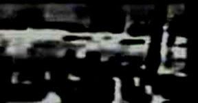
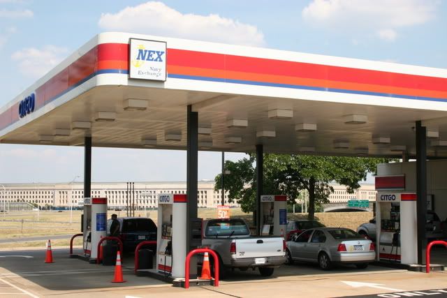
Here is a frame from the Nexcom/Citgo security video released last year. The frame we'll be looking at is 'Single pump side," camera 4, seen far left, second from top.
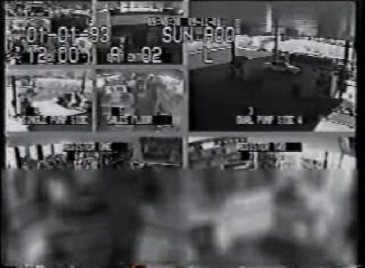
The view here looks southwest - note the canopy blocking the upper part of the view, and canopy shadow at the bottom - sun from the southeast, so the lot is sunlit and the scene washed out.
Many have noted the flashes of light and one interior camera darkening seen at 4:45 in the Citgo video, but the best clue I've found happens two seconds earlier - a large shadow on the ground, visible for one frame in camera 4's view. SOUTH of the Citgo.
This is a high-resolution still showing that frame.
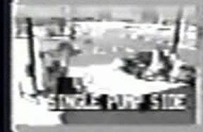
Can you spot the shadow already? If not, watch this short short video I did a while back using lower-res stills:
new window - Youtube
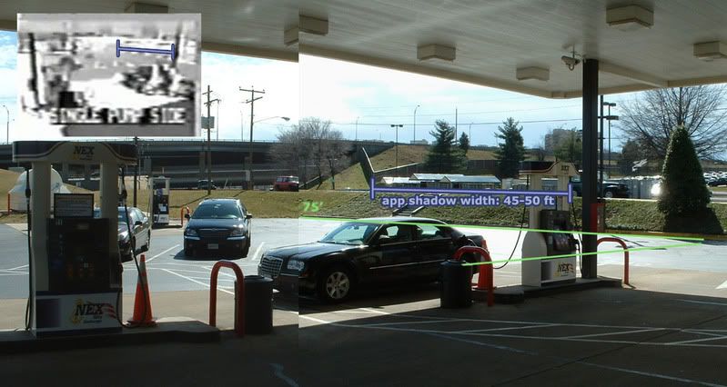
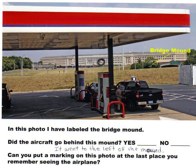
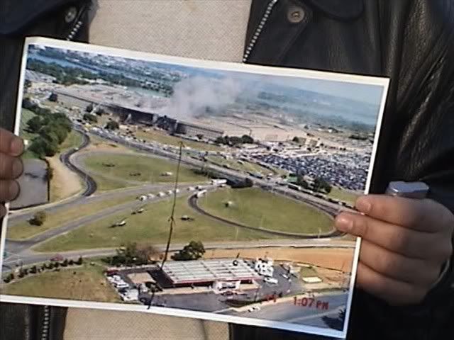
In this montage of two site photographs kindly provided by John Farmer – taken on his research trip there earlier this year – we can see about what the video is trying to show. The security camera was set higher than this and looking down, but at about this lateral angle. Using satelite maps, I measures the south parking lot at about 75 feet long and therefore the area occupied by shadow seems at least 45-50 feet across.
But it's not A shadow, but rather two dots, right? What's up with that?
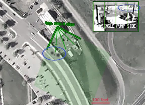
Subdividing the camera's view in 4, approximating its field of view on a satelite map, I have placed the shadow here, on South Joyce Street.
Factors at work to counter a clear view of the shadow include edge fuzzing due to altitude and refraction, road reflectivity, angle of view and surface topography, camera resolution, transfer resolution, and of course the shape of the object casting the shadow, in this case supposedly a twin-engine airliner.
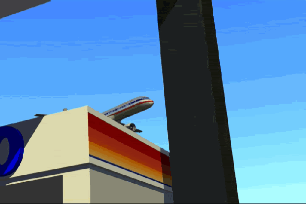
Here's a photo I found that helps clarify what we might expect to see: Note the 'missing' nosecone, and that the foremost portion of the shadow is made of two separate segments - an engine and the fuselage.

brightness and contrast adjustment of the Citgo shadow:
note warped shape of left shadow, and think of the raised sidewalk, obscuring its true length on the roadway behind that. Also note what seems a linear extension of the shadow at far right, on the other side of the support pole. Latent at lower contrasts, it pops out here. It doesn't seem to be present in the frames before or after, but I don't have the full set at high res, so I'm not sure if that's the left wing edge or not.
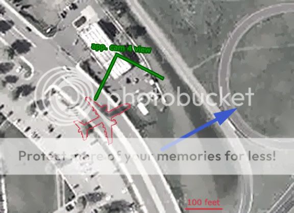
Therefore, it seems this is not altogether an implausible explanation. This is all to scale, the blue arrow showing the official heading and the official path location. Does this shadow line up with a plane on that line?
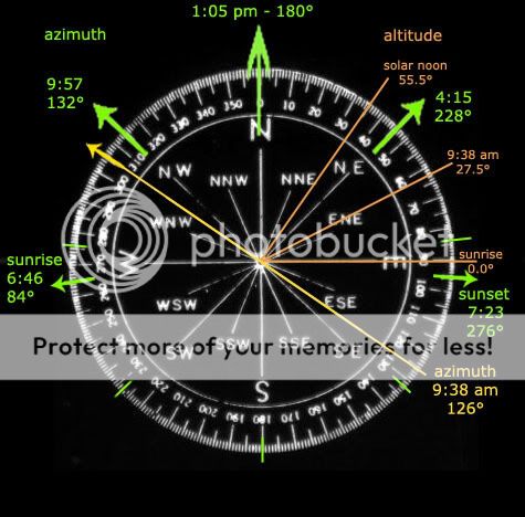
Here is mapped out the sun angles for 9/11/01 at the Capital. numbers from here
Azimuth is the direction to the sun measured in degrees from north, and altitude is the angle of its rays relative to the horizon (0 at sunrise and sunset, highest at solar noon, 1:05 pm at the Pentagon). I goofed on the altitude number here: at 9:38 it should actually be 25 degrees, not 27.5. I used the correct number below, just didn't update the dial.
Anyone care to double-check or challenge my calculations? I'm new to this detailed an analysis, and presuned steady change of both readings during the day.
This allows us to find this:
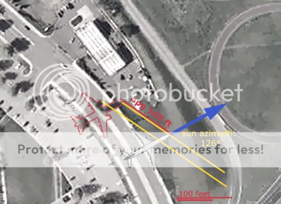
IF on the official path - which considering the downed poles and angled building damage, seems reasonable - then the shadow is about 165 feet NW of the plane.
THIS plus sun altitude allows us to find this:

And so we have a plane - Flight 77? - about 72 feet above that shadow at that moment, or about 125-130 feet above sea level. I don't have the final math, but an average pitch of no more than 5 degrees would put it into the Pentagon's first floor.
The position of the plane also puts it about 2 seconds away from impact at the official speed of 530 mph. Watching the Citgo video, I find that the more famous flashes happen 65 frames after the shadow first appears – 2.167 seconds. Measuring the rough distance from that location to the Pentagon, 1600 feet (plus app. 100 feet descended) - this yields a speed of about 535 mph, or just what the flight data recorded found inside the Pentagon says.
Significance:
We have on video, quite possibly, the shadow of Flight 77, just 2 seconds prior to impact. In terms of size and shape it's possible, its location fits the model and gives it the right altitude, and if linked to the later light effects (fireball?), its speed fits the profile of the 'official story.' It clearly contradicts the north flight path claims, unless possibly we argue for two planes.
Questions: any other legit possibilities for these dark patches besides actual informational alteration of the video? And anyone want to suggest alteration? It was 'held by the perps,' right?
[edit on 26-10-2007 by Caustic Logic]
several edits for clarity
[edit on 26-10-2007 by Caustic Logic]
Here is a frame from the Nexcom/Citgo security video released last year. The frame we'll be looking at is 'Single pump side," camera 4, seen far left, second from top.
The view here looks southwest - note the canopy blocking the upper part of the view, and canopy shadow at the bottom - sun from the southeast, so the lot is sunlit and the scene washed out.
Many have noted the flashes of light and one interior camera darkening seen at 4:45 in the Citgo video, but the best clue I've found happens two seconds earlier - a large shadow on the ground, visible for one frame in camera 4's view. SOUTH of the Citgo.
This is a high-resolution still showing that frame.
Can you spot the shadow already? If not, watch this short short video I did a while back using lower-res stills:
new window - Youtube
In this montage of two site photographs kindly provided by John Farmer – taken on his research trip there earlier this year – we can see about what the video is trying to show. The security camera was set higher than this and looking down, but at about this lateral angle. Using satelite maps, I measures the south parking lot at about 75 feet long and therefore the area occupied by shadow seems at least 45-50 feet across.
But it's not A shadow, but rather two dots, right? What's up with that?
Subdividing the camera's view in 4, approximating its field of view on a satelite map, I have placed the shadow here, on South Joyce Street.
Factors at work to counter a clear view of the shadow include edge fuzzing due to altitude and refraction, road reflectivity, angle of view and surface topography, camera resolution, transfer resolution, and of course the shape of the object casting the shadow, in this case supposedly a twin-engine airliner.
Here's a photo I found that helps clarify what we might expect to see: Note the 'missing' nosecone, and that the foremost portion of the shadow is made of two separate segments - an engine and the fuselage.
brightness and contrast adjustment of the Citgo shadow:
note warped shape of left shadow, and think of the raised sidewalk, obscuring its true length on the roadway behind that. Also note what seems a linear extension of the shadow at far right, on the other side of the support pole. Latent at lower contrasts, it pops out here. It doesn't seem to be present in the frames before or after, but I don't have the full set at high res, so I'm not sure if that's the left wing edge or not.
Therefore, it seems this is not altogether an implausible explanation. This is all to scale, the blue arrow showing the official heading and the official path location. Does this shadow line up with a plane on that line?
Here is mapped out the sun angles for 9/11/01 at the Capital. numbers from here
Azimuth is the direction to the sun measured in degrees from north, and altitude is the angle of its rays relative to the horizon (0 at sunrise and sunset, highest at solar noon, 1:05 pm at the Pentagon). I goofed on the altitude number here: at 9:38 it should actually be 25 degrees, not 27.5. I used the correct number below, just didn't update the dial.
Anyone care to double-check or challenge my calculations? I'm new to this detailed an analysis, and presuned steady change of both readings during the day.
This allows us to find this:
IF on the official path - which considering the downed poles and angled building damage, seems reasonable - then the shadow is about 165 feet NW of the plane.
THIS plus sun altitude allows us to find this:
And so we have a plane - Flight 77? - about 72 feet above that shadow at that moment, or about 125-130 feet above sea level. I don't have the final math, but an average pitch of no more than 5 degrees would put it into the Pentagon's first floor.
The position of the plane also puts it about 2 seconds away from impact at the official speed of 530 mph. Watching the Citgo video, I find that the more famous flashes happen 65 frames after the shadow first appears – 2.167 seconds. Measuring the rough distance from that location to the Pentagon, 1600 feet (plus app. 100 feet descended) - this yields a speed of about 535 mph, or just what the flight data recorded found inside the Pentagon says.
Significance:
We have on video, quite possibly, the shadow of Flight 77, just 2 seconds prior to impact. In terms of size and shape it's possible, its location fits the model and gives it the right altitude, and if linked to the later light effects (fireball?), its speed fits the profile of the 'official story.' It clearly contradicts the north flight path claims, unless possibly we argue for two planes.
Questions: any other legit possibilities for these dark patches besides actual informational alteration of the video? And anyone want to suggest alteration? It was 'held by the perps,' right?
[edit on 26-10-2007 by Caustic Logic]
several edits for clarity
[edit on 26-10-2007 by Caustic Logic]
here we go again with these damn conspiracy's. just let it go..... its already over with.
Originally posted by S.O.Blilbobby
here we go again with these damn conspiracy's. just let it go..... its already over with.
Oh no no, this is big. Wait, what's over with?
Before this goes any further let's just breathe in, and remember this:
Due to member demand, the 9/11 forum is now under close staff scrutiny.
Any inappropriate comments, insults, topic derailment, or trolling will result in immediate posting ban or account termination.
Let's stick to the topic.
Due to member demand, the 9/11 forum is now under close staff scrutiny.
Any inappropriate comments, insults, topic derailment, or trolling will result in immediate posting ban or account termination.
Let's stick to the topic.
Originally posted by Gemwolf
Before this goes any further let's just breathe in, and remember this:
Due to member demand, the 9/11 forum is now under close staff scrutiny.
Any inappropriate comments, insults, topic derailment, or trolling will result in immediate posting ban or account termination.
Let's stick to the topic.
I'm down with that, since the topic is my OP about the shadow. Thanks for the reminder as we move into the am where I sleep and the fur starts flying.
This is just a quick initial response but don't you have the plane pointed in the wrong direction in the photos where the shadow is diagrammed in?
Sorry if I'm off base here. It would be nice to have a wide angle shot that included the Citgo station and the Pentagon also, for people like me who
are not way into this particular discussion.
Apologies if I'm blundering here.
Edited: Sorry, my mistake. I did some checking against a wider panorama shot and you are correct.
[edit on 26-10-2007 by ipsedixit]
Apologies if I'm blundering here.
Edited: Sorry, my mistake. I did some checking against a wider panorama shot and you are correct.
[edit on 26-10-2007 by ipsedixit]
Originally posted by ipsedixit
This is just a quick initial response but don't you have the plane pointed in the wrong direction in the photos where the shadow is diagrammed in? Sorry if I'm off base here. It would be nice to have a wide angle shot that included the Citgo station and the Pentagon also, for people like me who are not way into this particular discussion.
Apologies if I'm blundering here.
Nice find CL!
I was thinking the same thing as ipsedixit after looking at the photos & data. I can see the the shadow being cast in a different position than the plane due to the angle of the Sun. BUT-
If the two elongated shadows on the same lateral line are indeed from the wings then it seems like it's heading will take it directly over the Citgo station and not adjacent to it.
2PacSade-
Another somewhat confusing detail is that the "single pump side" appears to have two pumps. You know, I think I'll just bow out of this one and
leave it to the experts. I feel like John John crawling around under the oval office desk.
This data has been PROVEN to have been manipulated.
Details here.
They removed the most relevant cameras just AFTER the attack and manipulated these views from the data before it was released unannounced a nd with no press 5 years later and 1 week after we announced Robert Turcios as a witness to the north side.
We know this because the manager of the citgo TOLD US that the views were online.
This "analysis" from CL is yet another neutralization attempt.
The alleged "shadow" in question is 2 dots.
A shadow of a massive 757 would be continuous.
To suggest that these 2 dots come from a jet strains credulity beyond belief.
CL... great research!
[sarcasm]No flyover evidence though! Must have been manipulated! [\sacrasm]
[sarcasm]No flyover evidence though! Must have been manipulated! [\sacrasm]
Originally posted by ipsedixit
Another somewhat confusing detail is that the "single pump side" appears to have two pumps. You know, I think I'll just bow out of this one and leave it to the experts. I feel like John John crawling around under the oval office desk.
It's called single pump side because there is one row of pumps while the north side has two rows.
North/double pump side:
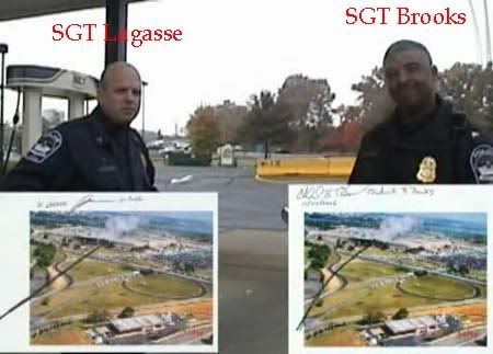
South or single pump side with highway sign that Robert Turcios saw the plane pull up over after passing by the north side of the station:
Here is a gif of Robert's approximate POV as the plane passed by him:
The notion that ALL of these witnesses are mistaken and that the two little dots from that proven manipulated data provided for by the perps came from a 757 is pretty ridiculous.
Really to accept this analysis as valid means you are choosing to dismiss the unrefuted testimony from ALL known witnesses who were there in favor of
accepting data that has been proven to be manipulated and was controlled and provided for by the suspect.
If you question the veracity of 9/11 AT ALL there would be zero logic in accepting such an illogical investigative approach.
If you question the veracity of 9/11 AT ALL there would be zero logic in accepting such an illogical investigative approach.
Originally posted by Caustic Logic
Here's a photo I found that helps clarify what we might expect to see: Note the 'missing' nosecone, and that the foremost portion of the shadow is made of two separate segments - an engine and the fuselage.
brightness and contrast adjustment of the Citgo shadow:
You have got to be kidding.
Missing nosecone?
Two separate segments?
What are you looking at?
In your example image I see a continuous shadow in the shape of a jet with the "foremost" part being the fuselage which is not visible AT ALL in the citgo video.
The notion that the mound would make the entire fuselage shadow AND the wings completely disappear make zero sense.
Are the dots supposed to be the engines or the wings?
Unless you are asserting that two orbs flew on the south side and knocked the poles down and hit the Pentagon you really do not have a valid point because those two dots in this proven manipulated data are clearly NOT from a jet.
reply to post by Craig Ranke CIT
Craig
Can I qualify what you mean by 'manipulated'?
Are you claiming that the Citgo video should contain another three panels, representing the three 'omitted' angles, or that the video content has been manipulated?
Craig
Can I qualify what you mean by 'manipulated'?
Are you claiming that the Citgo video should contain another three panels, representing the three 'omitted' angles, or that the video content has been manipulated?
Originally posted by Craig Ranke CIT
Really to accept this analysis as valid means you are choosing to dismiss the unrefuted testimony from ALL **my** witnesses who were there in favor of accepting data that has been proven to be manipulated and was controlled and provided for by the suspect.
Isnt that the appropriate way that should have been worded? The bolded is my edit
You did not interview EVERYONE that was at the Citgo station, on the ground, in their cars, in the Pentagon, in their homes. etc....
[edit on 26-10-2007 by CaptainObvious]
Originally posted by Caustic Logic
But it's not A shadow, but rather two dots, right? What's up with that?
Is it possible that the appearance of 'two dots' is the result of the shadow being seen on the roofs of the low buildings further back? In Farmer's shot, they are catching the sunlight with different intensities.
Originally posted by coughymachine
reply to post by Craig Ranke CIT
Craig
Can I qualify what you mean by 'manipulated'?
Are you claiming that the Citgo video should contain another three panels, representing the three 'omitted' angles, or that the video content has been manipulated?
Both.
The video content had to have been manipulated to remove these critical views.
They not only manipulated it to remove these views but even completely removed the most critical camera soon after the attack and never replaced it:
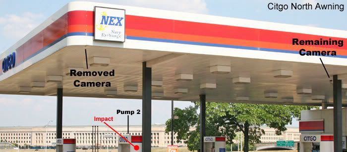
The manager TOLD us this direct and ALSO told us that this camera had a view of the Pentagon itself and clearly it was pointing right towards the alleged impact point.
It would have definitely caught the plane as it passed by the north of the citgo.
To release this data quietly with these critical views manipulated out of the multiplex feed not only implicates them in a cover-up but is a federal offense within itself.
reply to post by CaptainObvious
Huh?
I don't own any witnesses.
We have interviewed all known witnesses to the plane who were at the citgo station.
There aren't many other vantage points where you would be able to definitively tell what side of the station the plane flew which is why they are so critical.
If you know of anyone else at the station that saw the plane or ANYONE that was ANYWHERE who can definitively state what side of the station the plane flew let us know.
As it stands all known witnesses are in 100% agreement and refuted by nobody so it would be rather silly to suggest that the two dots in this proven manipulated data that was controlled by the suspect is sufficient to counter them.
reply to post by Craig Ranke CIT
Would those three omitted views have appeared on the same screen as the seven views we currently have?
Is it your opinion that the 'shadow' CL has analysed has been edited in?
Would those three omitted views have appeared on the same screen as the seven views we currently have?
Is it your opinion that the 'shadow' CL has analysed has been edited in?
reply to post by coughymachine
The multiplex feed sends all camera views to the same screen.
No data controlled and provided for by the suspect is valid evidence in defense of the suspect but the notion that this data has been proven to be manipulated it becomes doubly invalid.
The dots prove nothing whether or not they were edited in.
new topics
-
God's Righteousness is Greater than Our Wrath
Religion, Faith, And Theology: 3 hours ago -
Electrical tricks for saving money
Education and Media: 6 hours ago -
VP's Secret Service agent brawls with other agents at Andrews
Mainstream News: 7 hours ago -
Sunak spinning the sickness figures
Other Current Events: 8 hours ago -
Nearly 70% Of Americans Want Talks To End War In Ukraine
Political Issues: 8 hours ago -
Late Night with the Devil - a really good unusual modern horror film.
Movies: 10 hours ago
top topics
-
VP's Secret Service agent brawls with other agents at Andrews
Mainstream News: 7 hours ago, 9 flags -
Cats Used as Live Bait to Train Ferocious Pitbulls in Illegal NYC Dogfighting
Social Issues and Civil Unrest: 12 hours ago, 8 flags -
Electrical tricks for saving money
Education and Media: 6 hours ago, 4 flags -
HORRIBLE !! Russian Soldier Drinking Own Urine To Survive In Battle
World War Three: 16 hours ago, 3 flags -
Nearly 70% Of Americans Want Talks To End War In Ukraine
Political Issues: 8 hours ago, 3 flags -
Sunak spinning the sickness figures
Other Current Events: 8 hours ago, 3 flags -
Late Night with the Devil - a really good unusual modern horror film.
Movies: 10 hours ago, 2 flags -
The Good News According to Jesus - Episode 1
Religion, Faith, And Theology: 13 hours ago, 1 flags -
God's Righteousness is Greater than Our Wrath
Religion, Faith, And Theology: 3 hours ago, 0 flags
active topics
-
Nearly 70% Of Americans Want Talks To End War In Ukraine
Political Issues • 13 • : Freeborn -
Mood Music Part VI
Music • 3101 • : ThatSmellsStrange -
VP's Secret Service agent brawls with other agents at Andrews
Mainstream News • 41 • : ThatSmellsStrange -
HORRIBLE !! Russian Soldier Drinking Own Urine To Survive In Battle
World War Three • 32 • : DaRAGE -
New whistleblower Jason Sands speaks on Twitter Spaces last night.
Aliens and UFOs • 55 • : baablacksheep1 -
Cats Used as Live Bait to Train Ferocious Pitbulls in Illegal NYC Dogfighting
Social Issues and Civil Unrest • 20 • : Asher47 -
Electrical tricks for saving money
Education and Media • 4 • : Lumenari -
DONALD J. TRUMP - 2024 Candidate for President - His Communications to Americans and the World.
2024 Elections • 514 • : WeMustCare -
The Acronym Game .. Pt.3
General Chit Chat • 7744 • : bally001 -
Truth Social goes public, be careful not to lose your money
Mainstream News • 128 • : Astyanax