It looks like you're using an Ad Blocker.
Please white-list or disable AboveTopSecret.com in your ad-blocking tool.
Thank you.
Some features of ATS will be disabled while you continue to use an ad-blocker.

NAN MADOL - Ancient Weather Manipulation Technology??
page: 1share:
NAN MADOL - Remnant of technology from our ancient past?
So I had posted this information in another thread already - www.abovetopsecret.com... - but there's not a great deal of action there.
I am posting it again here to see what you guys think of it. I want to gauge ATSer's thoughts on possible ancient technology from, IMO, the Lemurian civilisation that existed sometime in the last 5,000 to 15,000 years. The great former civilisation is said to have existed in the Pacific region and is thought to have been wiped out after a series of cataclysms slowly sunk it beneath the Pacific Ocean.
The ancient weather manipulation structure/technology is Nan Madol, situated on the shore of Pohnpei in Micronesia.
The below is a compilation of Frank Joseph's work from his book The Lost Civilisation of Lemuria, and other research.
The below explains one potential reason for Nan Madol which, IMO, could only be the result of a past civilisation which worked with the earth, (not against it as we do), to achieve amazing results. It appears to be Lemurian technology at work.
BACKGROUND
Nan Madol is built on a coral reef only five feet above sea level between the equator and the eleventh parallel. It features 250 tonnes of prismatic magnatized basalt spread over 170 acres. The basalt is magnetized in a highly unusual and unnatural manner - this is an important and intentional affect. The average weight of each stone slab is 5 tonnes, with some weighing up to 25 tonnes each.
It is not an ancient city.
AGE?
It is presumed to be approximately 12,000 years old. It is the same suspected age as the underwater ruins found off the coast of Yonaguni, Japan.
Several attempts to date Nan Madol have been carried out using Carbon-14 dating techniques. In the 1960's, scientists from the Smithsonian Institute tested residue inside what they deduced was a turtle oven and came up with a habitation period of 1285 AD. Additional testing on a nearby ash layer showed it was older by 200 years.
Broader thermoluminescence testing on broken pottery shards found below artificial fill at Nan Madol's Dapahu Islet dated to 2,000 years ago.
HOWEVER, pottery has never been known to be used on or near the island and the natives have no knowledge whatsoever of pottery. Additionally, the only thing these tests actually prove is that someone ate a turtle at Nan Madol in the thirteenth century and that some dropped a jug there at the time of Christ. It in no way gives a construction date for Nan Madol.
Sea level analysis, study of ocean-floor sediment, and examination of surrounding semi-submerged ruins at the base of Nan Madol and in the surrounding waters of Nan Madol put the approximate date for construction at approximately 12,000 years ago.
The basic concept is that the last time that Nan Madol's underwater ruins would have been on dry land and above sea level is approximately 12,000 years ago - so unless some of it was intended to be built underwater then I don’t see how this could be wrong.
Conventional/mainstream scholars have failed to determine how it was made, who built it, when it was built, for what purpose it was built and where the building materials came from.
LOCATION AND PURPOSE
It is positioned roughly half way between Hawaii and the Philipines, at the location where severe storms and typhoons are generated when cold air is brought into contact with the warm waters of the Caroline Islands - many severe storms originate from Nan Madol's location. This is no coincidence. Because severe storms originate there, it is very rarely hit by these storms, making it the safest location in the pacific. Now the major effect which contribute to typhoons and hurricanes is electromagnetic energy - NOT water temperature (see Joseph Newman's work below), temperature is important, obviously, but is secondary.
Joseph Newman's findings
Nan Madol and Kosrae (a similar structure to Nan Madol also located in the Federated States of Micronesia) create a 300-mile-long zone in which typhoons are born and the first stages of their power and severity are developed. The storms soon grow much larger and wind up ravishing the Philippines. Until recently, they were thought to be the exclusive result of masses of cold air convectored into conflict with water’s warmer temperatures. Mainstream meteorologists believe cyclones are produced during a three-step process by the initial intensity of the storm, temperature changes in the air it brings about, and subsequent heat exchange with the ocean. However, late in last century, Joseph Newman declared that:
The major effect in respect to hurricanes is electromagnetic. For a hurricane to remain a hurricane, it does not depend solely on the heat of the water over which it travels.
Proof: The average temperature of the waters of the Gulf of Mexico, 20 miles of the Louisiana coast, is as follows:
July, 82 degrees F
August, 87 degrees F
September, 82 degrees F
October, 76 degrees F
November, 66 degrees F
If what the weather experts said were true, the greatest number and most destructive hurricanes would always occur in July and August, not true! Fact: The peak hurricane season is only in September – not July or August. September and October have 300 per cent more hurricanes of greater destruction than July or August, even November has 80 per cent as many hurricanes as July and August.
Therefore, Newman deduced that temperature was of secondary importance in the production of hurricanes, adding that electromagnetism was the most important factor.
Platinum and silver 'bars' were found within Nan Madol.
WHAT POWERS IT?
Pohnpei, the island attached to Nan Madol, has unique and constant subtle siesmic activity. Seismic activity generates piezoelectricity. The piezoelectricity works with the strangely magnetized basalt to focus a concentrated coronal discharge skyward.
continued next post....
continued.....
CONCLUSION
Now considering the location of Nan Madol, the unique and intentionally altered magnetism of the basalt and the layout of the ruin, it can easily be argued that Nan Madol was ancient weather manipulation technology used to diffuse dangerous storms before they can build up. The coronal discharge let off by the magentized basalt, which is generated by piezoelectricity sourced by the island's constant subtle siesmic activity, means that Nan Madol could react with a storm's electromagnetic elements and effectively diffuse the storm.
DO further research if you doubt it, but it makes sense. Remember this is a summarised version of over 50 pages in Joseph's book mentioned before MUCH greater detail is available.
Lets use this thread to list and discuss anyone elses theories as to the whats, whys or whens of Nan Madol, lets lay them out on the table now.
But consider this - there is some 200 million metric tonnes of stone built on a coral reef surrounded by ocean. If built by natives with no serious construction technology then how did they do it? I believe this once again goes back to ancient lost technologies and potentially frequency manipulation and acoustic resonance. (see the Hutchinson Effect for someone who may be possibly rediscovering this technology).
Let's resist the temptation to turn this into a debate on whether or past civilisations ever existed, the thread mentioned previously has great discussion on this.
I'm more interested in what people think about Nan Madol.
Just going over what you've written, I must say that I'm rather intrigued. I'm going to do a little digging and see what I find about the
structure, but hopefully someone more knowledgable about these sorts of things will post their 'two-cents' soon.
Oi! I was just about to start a thread on this
Anyway, to start with, and to add a balance to srsen's post, here is some additional orthodox info on Nan Madol
www.janesoceania.com...
I'd advise checking the link because there's a lot more info there about the site.
www.janesoceania.com...
I'll be back later to discuss some of the points raised in srsen's post
Anyway, to start with, and to add a balance to srsen's post, here is some additional orthodox info on Nan Madol
At what time the first settlers arrived on Pohnpei is unknown. Eventually stone platforms, house foundations, walls, pavings and tombs, earth terraces and mounds, and other architectural features began to appear at various locations along the coasts, in valley, and on hillside sites of the island's interior. during the first or second century A.D., people apparently were inhabiting the coastal area that became the site of Nan Madol. Here Stephen Athens (1983:53) has recorded radiocarbon dates of this time range from archaeological deposits found below the artificial fill and low-tide level of Dapahu Islet (93). Geologic subsidence coupled with sea level rise on Pohnpei accounts for the present-day inundation of early coastal habitation areas.
William Ayres and Alan Haun (1978) of the University of Oreon have documented several stages of construction for the Usendau (104) and Pahnkadira (33) islet bases, the former going back to the eighth or ninth century A.D. About 1000 or 1100, pottery ceased to be used at Nan Madol. the early use of pottery followed by its discontinuance is a common pattern in Oceania.
Apparently not until sometime around 1200 to 1300 did elaborate megalithic architecture begin at Nan Madol. By this time Pohnpei is believed to have been conquered and unified by a paramount chief called the saudeleur, meaning lord of Deleur, a small political unit that evidently encompassed Temwen Island and neighbouring areas. Eventually, the hegemony of the saudeleur seems to have extended throughout the entire island of Pohnpei.
Under the reign of the sandeleur, Nan Madol flourished and expanded to its present size. This was the time of greatest architectural achievement, when walls of stacked prismatic basalt 18 to 23 feet high were constructed around Nandauwas (113) and the number of artificial islets increased substantially. Some had coral fill u to 7 feet above sea level at high tide, while one of Pahnwi's platforms was some 20 feet high. Several of the islets measure well more than 100 yards on a side and contain areas roughly equivalent to three football fields. Immense seawalls and breakwaters were erected to protect the chiefly center from the relentless pounding of ocean waves in the exposed coastal site.
The downfall of the saudeleur is estimated to have occurred during the early 1600s. Pohnpeian oral traditions link the paramount's demise to the Thunder God, whose temple is located on a large, three-tiered platform on Pahnkadira Islet (33), where the saudeleur lived. The Thunder god's son, the legendary Isokelekel, is said to have established a new political order presided over by a high chief called the nahnmwarki. Perhaps as a safeguard against the re-emergence of a paramount on Pohnpei, Isokelekel divided the island into three autonomous chiefdoms.
Isokelekeo himself became the first nahnmwarki of Madolenihmw, the chiefdom that included Nan Madol, here the next six nahnmwarki resided. It is estimated that during the early 1700s the nahnmwarki removed his residence from Nan Madol, but people seemed to have continued living there a little while longer. by the 1820s, when intensive Western contact began with Pohnpei, people had ceased to live at Nan Madol though it continued to be used through the mid 1800s for periodic religious observances.
www.janesoceania.com...
I'd advise checking the link because there's a lot more info there about the site.
www.janesoceania.com...
I'll be back later to discuss some of the points raised in srsen's post
Originally posted by srsen
It is positioned roughly half way between Hawaii and the Philipines, at the location where severe storms and typhoons are generated when cold air is brought into contact with the warm waters of the Caroline Islands - many severe storms originate from Nan Madol's location.
Nan Madol and Kosrae (a similar structure to Nan Madol also located in the Federated States of Micronesia) create a 300-mile-long zone in which typhoons are born and the first stages of their power and severity are developed.
This is a claim made by Frank Joseph which I wish to dispute:
This map: earthobservatory.nasa.gov... shows the tracks of all tropical cyclones. Nan Madol is situated to the north of New Guinea and lies on the southern edge of the Pacific Typhoon zone. However, as can be seen, there is really nothing remarkable about it's location, with many typhoons starting much further east.
At best I think it could be argued that Nan Modal sits at a longitude around which tropical storms often develop into full blown cyclones - ie they usually start further east but it's around the longitude of Nan Madol where they most often become actual typhoons.
Coincidence or design?
Essan,
The information you provided concerning the orthodox origins of Nan Madol has a few holes which I would like to pick at.
The author of this information must have found very little evidence of these first settlers arriving in Nan Madol itself as there is no clue as to WHEN they arrived - is this coz there is no actual evidence to carbon-14 test? Additionally, the info says that there were discoveries made at 'various locations along the coast' - where exactly though? We know that there was and still is native inhabitants of Pohnpei so what discoveries are exactly being described here? Findings from Nan Madol itself (?)or simply from Pohnpei's other previously inhabited coastal regions?
Ok, this proves that people had inhabited the Nan Madol ruins about 2,000 years ago.
This shows that structures may have been built on top of Nan Madol. The complete Nan Madol structure does extend quite far beneath the ocean's surface, suggesting that it had been consistently built-up over the ages. This could have been to combat the rising sea level??
Ok but pottery has never been common on Pohnpei.
How did they arrive at this fact? A simple study of the ocean floor surrounding Nan Madol will reveal that structures significantly predating 700-800 years ago are found buried deep in ocean sediment - as previously mentioned, putting these ruins on dry land dates the ruins to 12,000 years ago approx.
The paragraphs concerning Saudeleur and Isokelekel are interesting reading but have little to do with Nan Madol's origins and purpose.
Interesting information and I would suggest that this is precisely what Joseph was referring to. I obviously can't confirm this without speaking to man directly (cannot locate email address for him) but it ties in well with the full expanded version (from his book) which I merely summarized. IF Nan Madol is ancient weather manipulation technology then being located where a storm goes from a baby to a full-blown beast would be ideal.
continued next post….
[edit on 15-10-2007 by srsen]
The information you provided concerning the orthodox origins of Nan Madol has a few holes which I would like to pick at.
from Essan's quote
At what time the first settlers arrived on Pohnpei is unknown. Eventually stone platforms, house foundations, walls, pavings and tombs, earth terraces and mounds, and other architectural features began to appear at various locations along the coasts, in valley, and on hillside sites of the island's interior.
The author of this information must have found very little evidence of these first settlers arriving in Nan Madol itself as there is no clue as to WHEN they arrived - is this coz there is no actual evidence to carbon-14 test? Additionally, the info says that there were discoveries made at 'various locations along the coast' - where exactly though? We know that there was and still is native inhabitants of Pohnpei so what discoveries are exactly being described here? Findings from Nan Madol itself (?)or simply from Pohnpei's other previously inhabited coastal regions?
from Essan's quote
During the first or second century A.D., people apparently were inhabiting the coastal area that became the site of Nan Madol. Here Stephen Athens (1983:53) has recorded radiocarbon dates of this time range from archaeological deposits found below the artificial fill and low-tide level of Dapahu Islet (93).
Ok, this proves that people had inhabited the Nan Madol ruins about 2,000 years ago.
from Essan's quote
William Ayres and Alan Haun (1978) of the University of Oreon have documented several stages of construction for the Usendau (104) and Pahnkadira (33) islet bases, the former going back to the eighth or ninth century A.D.
This shows that structures may have been built on top of Nan Madol. The complete Nan Madol structure does extend quite far beneath the ocean's surface, suggesting that it had been consistently built-up over the ages. This could have been to combat the rising sea level??
from Essan's quote About 1000 or 1100, pottery ceased to be used at Nan Madol. the early use of pottery followed by its discontinuance is a common pattern in Oceania.
Ok but pottery has never been common on Pohnpei.
from Essan's quote Apparently not until sometime around 1200 to 1300 did elaborate megalithic architecture begin at Nan Madol.
How did they arrive at this fact? A simple study of the ocean floor surrounding Nan Madol will reveal that structures significantly predating 700-800 years ago are found buried deep in ocean sediment - as previously mentioned, putting these ruins on dry land dates the ruins to 12,000 years ago approx.
The paragraphs concerning Saudeleur and Isokelekel are interesting reading but have little to do with Nan Madol's origins and purpose.
from Essan's quote At best I think it could be argued that Nan Modal sits at a longitude around which tropical storms often develop into full blown cyclones - ie they usually start further east but it's around the longitude of Nan Madol where they most often become actual typhoons.
Coincidence or design?
Interesting information and I would suggest that this is precisely what Joseph was referring to. I obviously can't confirm this without speaking to man directly (cannot locate email address for him) but it ties in well with the full expanded version (from his book) which I merely summarized. IF Nan Madol is ancient weather manipulation technology then being located where a storm goes from a baby to a full-blown beast would be ideal.
continued next post….
[edit on 15-10-2007 by srsen]
continued…..
Returning to Nan Madol's potential purpose, Pohnpei natives tell stories of 'ghost lights' appearing on Nan Madol. These lights are said to take on the appearance of an almost flickering ball-lightning phenomena. Tales exist of people found dead after spending an evening at Nan Madol and confronting these 'ghost lights'.
Is it possible that these 'ghost lights' are the results of subtle earth tremors causing a build-up in piezoelectricity which is 'activating' some part of Nan Madol and causing, for a moment, the structure to begin to do whatever it was it used to do when originally built? This could send electromagnetic charge shooting around the structure causing the 'ghost lights' and potentially killing anyone who came into contact with it. Remember, the magnetism of the basalt would never diminish….
Some non fringe reading about NM:
books.google.com...
On the road of the winds by Patrick Kirch
Archaelogical Survey in Micronesia
William S. Ayres
Current Anthropology, Vol. 20, No. 3 (Sep., 1979), pp. 598-600
This article consists of 3 page(s).
books.google.com...
Upon a Stone Altar: A history of the island of Pohnpei to 1890
books.google.com...
The archaeology of Micronesia Paul Rainbird
www.springerlink.com...
Prehistory in the northwest tropical Pacific: The Caroline, Mariana, and Marshall Islands
A great deal more science on Nan can be found by running a search thru Google Scholar.
books.google.com...
On the road of the winds by Patrick Kirch
Archaelogical Survey in Micronesia
William S. Ayres
Current Anthropology, Vol. 20, No. 3 (Sep., 1979), pp. 598-600
This article consists of 3 page(s).
books.google.com...
Upon a Stone Altar: A history of the island of Pohnpei to 1890
books.google.com...
The archaeology of Micronesia Paul Rainbird
www.springerlink.com...
Prehistory in the northwest tropical Pacific: The Caroline, Mariana, and Marshall Islands
A great deal more science on Nan can be found by running a search thru Google Scholar.
oh if only i had time to read all them!
I'm kind of hoping you have read at least some of them Hanslune because i would like to know this -
What do these books say in regards to the history and origin of the Pacific cultures and that of Nan Madol itself?
Seeing that almost every culture in the Asia-Pacific region can trace it roots to a motherland or race of forefathers who's home sunk beneath the ocean millennia ago, i would be interested to hear the orthodox angle on these origins.
I would also like to know how these books explain the many anomalies i have listed in regards to Nan Madol. Just curious on the 'non-fringe' ideas...
Howdy Srsen
Actually they can't, Lemuria is fictional, most believe and the evidence supports the early people coming out of Formosa/southern China or the Siamannam area
The expansion of the people whom the western world labeled "Polynesians" begins about 40,000 years ago, with a major move forward into and onto the smaller island snear New Guinea around 3500-4000 BP. Modern historical linguistic studies confirm that the 36 documented Polynesian languages form a single branch of the great Austronesian language family. They can all be traced back to a Proto Polynesian language, for which more than 4,000 words have now been reconstructed.
Hmmm have you tried researching it? I always recommend to people who are busy, 'thinking outside the box' to actually figure where the box is first.
How was it made, by taking stone from quarries and floating it across to the site, a trail of lost/sunken stones can be seen underwater. The stones are naturally that shape. A number of quarry sites for the naturally occuring stone basalt prisms have been found but no direct link has been agreed upon.
Age? 800 years with evidence that people were in the area around 2,200 BP
No pottery? Food and especially water were brought into the site. Not sure where the no pottery idea comes from. Lapita pottery has been found there.
People who have studied the site and the local culture think the site was for an elite center, a special place of residence for the nobility and of mortuary activities presided over by priests. Its population almost certainly did not exceed 900+, and may have been less. Although many of the residents were chiefs, the majority were commoners. Nan Madol served, in part, as a means by which the ruling Saudeleur chiefs controlled the nobility.
"Seeing that almost every culture in the Asia-Pacific region can trace it roots to a motherland or race of forefathers who's home sunk beneath the ocean millennia ago, i would be interested to hear the orthodox angle on these origins.
Actually they can't, Lemuria is fictional, most believe and the evidence supports the early people coming out of Formosa/southern China or the Siamannam area
The expansion of the people whom the western world labeled "Polynesians" begins about 40,000 years ago, with a major move forward into and onto the smaller island snear New Guinea around 3500-4000 BP. Modern historical linguistic studies confirm that the 36 documented Polynesian languages form a single branch of the great Austronesian language family. They can all be traced back to a Proto Polynesian language, for which more than 4,000 words have now been reconstructed.
I would also like to know how these books explain the many anomalies i have listed in regards to Nan Madol. Just curious on the 'non-fringe' ideas...
Conventional/mainstream scholars have failed to determine how it was made, who built it, when it was built, for what purpose it was built and where the building materials came from.
Hmmm have you tried researching it? I always recommend to people who are busy, 'thinking outside the box' to actually figure where the box is first.
How was it made, by taking stone from quarries and floating it across to the site, a trail of lost/sunken stones can be seen underwater. The stones are naturally that shape. A number of quarry sites for the naturally occuring stone basalt prisms have been found but no direct link has been agreed upon.
Age? 800 years with evidence that people were in the area around 2,200 BP
No pottery? Food and especially water were brought into the site. Not sure where the no pottery idea comes from. Lapita pottery has been found there.
People who have studied the site and the local culture think the site was for an elite center, a special place of residence for the nobility and of mortuary activities presided over by priests. Its population almost certainly did not exceed 900+, and may have been less. Although many of the residents were chiefs, the majority were commoners. Nan Madol served, in part, as a means by which the ruling Saudeleur chiefs controlled the nobility.
I dont have time for a longer reply right now but i just wanted to drop a pic in here.
THis is in reference to the line that Lemuria is fictional.
The below pic was found in one of the western monasteries of Tibet - it is believed to be 25,000 years old. Now before someone else says, i will - no, i dont have any proof that this map really was found in a western monastry in Tibet - but there are many maps, both old (real) and new (fake), which show Lemuria clearly existed at one time. (oh and the 1931 on the map, well the map was supposedly re-discovered in 1931)
By the way Hanslune, i'm not ignoring your points as they are quite good, i just need to find an hour or two to put a decent response together - its like doing a bloody school assignment sometimes!
[edit on 18-10-2007 by srsen]
[edit on 18-10-2007 by srsen]
Howdy Srsen
That is okay, I was gone from here for two-weeks just recently, take your time.
I'm highly skeptical of that map to say the least. Remember before the theory of continental drift was proved earlier scientists were trying to deal with why similar geology and fossils were found in places thousands of miles away and divided by oceans. Lemuria was a theory for a land bridge (To explain why Lemurs were in India and Madagascar with no obvious connection). Many hypothetical submerged land bridges and continents were proposed during the 19th century, in order to account for the present distribution of species.
These theories all collasped when evidence for the theory of plate tectonics and continental drift were accepted by the larger scientific community and extensive exploration of the sea beds demonstrated a lack of substance for such stories. Now there are seamounts but drilling into some of them have shown they were slowly submerged millions of years ago.
Added point, I thought I recognized that map and went to look it up. Its one by the Colonel! It is a Churchward map showing how he thought Mu refugees spread out after the cataclysm through South America, along the shores of Atlantis and into Africa. He lived and travelled in India for many years so a visit to Tibet is a possibility. In his 1931 book, children of Mu he claimed he travelled thru Western Tibet.
Basically the map is imaginative but unsupported by Oceanography, and in particular seafloor spreading and Plate Tectonics have left no scientific basis for geologically recent lost continents such as Mu, Atlantis and Lemuria. I believe this is another version of it that was reproduced in a newspaper in the 1930's
[edit on 18-10-2007 by Hanslune]
I actually saw a documentairy on tv about this island. They even showed how the created it. They basically took basalt from a extinct volcano and
heated it up and cooled it down again causing it to split.
OK, it took a bit, but I can finally reply to Hanslune’s post.
Now let’s look closely at that – all that information is referring to the movements of “Polynesian” people. This does not necessarily mean anything in regards to Lemuria. Lemuria was very possibly developing either at the same time as these “Polynesians” or already established while these movements were going on. The history of the Pacific region would be more in-depth and complicated than the movements of the “Polynesians” alone.
We also have to consider that, for whatever reason, Lemuria has been covered up, denied. This does not mean it does not exist (we all know this). Of course a standard history book won’t contain information on the movements and history of the Lemurian people, but it will certainly tell us all bout everything else.
USING LANGUAGE TO HIGHLIGHT ANCESTRY
Easter Island
Hanslune brought up language in the last quote and it got me to remember about another piece of information I would like to ad at this point.
Rongorongo – A script used on Easter Island.
It is believed by mainstream researchers that the ancient Andeans introduced civilisation to Easter Island, however what they have all conveniently forgotten is that the Andeans did not possess a written language (such as Rongorongo).
So how could they introduce civilisation to Easter Island but not introduce Easter Island’s written language? It makes no sense.
Additionally, the Cyclopean walls at Easter Island are older than their Cuzco (Andean) counterparts. (see Mark Williams’ and Katherine Routledge’s work).
So the most likely scenario here is that BOTH civilisations were influenced by an outside source common to them both. Impressions made by a shared influence on two widely separated locations would explain their important, otherwise unexplained similarities.
The Pre-Inca Uru of Lake Titicaca, the ancestral Polynesian Uru-keu and Easter Island’s Uru do not prove one people’s influence over another, but rather that they were all influenced by an external power, referred to by some Polynesians as Uru – another name for the Pacific Motherland, or Lemuria.
What Easter Island and pre-conquest southern Peru do share, however, is the traditional belief that their organised society owes its existence to a culture-bearer arriving in the remote past from a distant land which had been long-since destroyed by catastrophe. He was known to the Easter Islanders as Hotu Matua and to the Inca as Kon-Tiki-Viracocha.
The many similarities of the two cultures are said to have come from the lost homeland of their founding fathers – Lemuria. So essentially, both cultures originated elsewhere, Lemuria, and then developed their own unique cultures based on the foundation of their Lemurian origins.
Wait a second – some of the magnetised basalt blocks were upwards of 25 tonnes each – 250 million tonnes in total – HOW COULD THIS BE FLOATED???? Seriously, this is not possible.
Think about it – according to mainstream science, the natives of Pohnpei, a people who didn’t even make pottery, were supposed to have floated 250 million tonnes of prismatic magnetised basalt across vast ocean stretches?? That’s about as unbelievable as the Egyptian pyramids being built with that stupid bloody ramp theory.
Continued next post........
The expansion of the people whom the western world labeled "Polynesians" begins about 40,000 years ago, with a major move forward into and onto the smaller island snear New Guinea around 3500-4000 BP. Modern historical linguistic studies confirm that the 36 documented Polynesian languages form a single branch of the great Austronesian language family. They can all be traced back to a Proto Polynesian language, for which more than 4,000 words have now been reconstructed.
Now let’s look closely at that – all that information is referring to the movements of “Polynesian” people. This does not necessarily mean anything in regards to Lemuria. Lemuria was very possibly developing either at the same time as these “Polynesians” or already established while these movements were going on. The history of the Pacific region would be more in-depth and complicated than the movements of the “Polynesians” alone.
We also have to consider that, for whatever reason, Lemuria has been covered up, denied. This does not mean it does not exist (we all know this). Of course a standard history book won’t contain information on the movements and history of the Lemurian people, but it will certainly tell us all bout everything else.
USING LANGUAGE TO HIGHLIGHT ANCESTRY
Easter Island
Hanslune brought up language in the last quote and it got me to remember about another piece of information I would like to ad at this point.
Rongorongo – A script used on Easter Island.
It is believed by mainstream researchers that the ancient Andeans introduced civilisation to Easter Island, however what they have all conveniently forgotten is that the Andeans did not possess a written language (such as Rongorongo).
So how could they introduce civilisation to Easter Island but not introduce Easter Island’s written language? It makes no sense.
Additionally, the Cyclopean walls at Easter Island are older than their Cuzco (Andean) counterparts. (see Mark Williams’ and Katherine Routledge’s work).
So the most likely scenario here is that BOTH civilisations were influenced by an outside source common to them both. Impressions made by a shared influence on two widely separated locations would explain their important, otherwise unexplained similarities.
The Pre-Inca Uru of Lake Titicaca, the ancestral Polynesian Uru-keu and Easter Island’s Uru do not prove one people’s influence over another, but rather that they were all influenced by an external power, referred to by some Polynesians as Uru – another name for the Pacific Motherland, or Lemuria.
What Easter Island and pre-conquest southern Peru do share, however, is the traditional belief that their organised society owes its existence to a culture-bearer arriving in the remote past from a distant land which had been long-since destroyed by catastrophe. He was known to the Easter Islanders as Hotu Matua and to the Inca as Kon-Tiki-Viracocha.
The many similarities of the two cultures are said to have come from the lost homeland of their founding fathers – Lemuria. So essentially, both cultures originated elsewhere, Lemuria, and then developed their own unique cultures based on the foundation of their Lemurian origins.
How was it made, by taking stone from quarries and floating it across to the site, a trail of lost/sunken stones can be seen underwater. The stones are naturally that shape. A number of quarry sites for the naturally occuring stone basalt prisms have been found but no direct link has been agreed upon.
Wait a second – some of the magnetised basalt blocks were upwards of 25 tonnes each – 250 million tonnes in total – HOW COULD THIS BE FLOATED???? Seriously, this is not possible.
Think about it – according to mainstream science, the natives of Pohnpei, a people who didn’t even make pottery, were supposed to have floated 250 million tonnes of prismatic magnetised basalt across vast ocean stretches?? That’s about as unbelievable as the Egyptian pyramids being built with that stupid bloody ramp theory.
Continued next post........
Continued.....
NAN MADOL’S NATIVE POPULATION
Pohnpeians today lay little claim to Nan Madol as far as who built it. They have no tradition of touching the quarry, they don’t know who hewed the stone, when it was done or why the work was ceased. They pretty much avoid Nan Madol and consider it evil.
To quote a US Department of Interior report – “The unwritten history of Pohnpei indicates that Nan Madol was constructed by or under the direction of people not native to the island of Pohnpei.”
Well I’ve sat here for an hour going through my information and I cant find for the life of me the info on Pohnpeians not using pottery. I know I have it but I cant bloody find it. So I cant help with the pottery thing. Annoying Sorry
I’m sure some of the basalt rocks at Nan Madol can be explained this way but it STILL doesn’t explain the problem of how they moved all this basalt into its precise position.
There a few sites in which are claimed to be the quarry for Nan Madol, and whether they are not is irrelevant (the rocks had to come from somewhere after all), the important answer we need here is how did 25 tonne blocks get moved from quarry to site and then how did they get lowered into position? Island natives could not perform the task.
NAN MADOL’S NATIVE POPULATION
Pohnpeians today lay little claim to Nan Madol as far as who built it. They have no tradition of touching the quarry, they don’t know who hewed the stone, when it was done or why the work was ceased. They pretty much avoid Nan Madol and consider it evil.
To quote a US Department of Interior report – “The unwritten history of Pohnpei indicates that Nan Madol was constructed by or under the direction of people not native to the island of Pohnpei.”
No pottery? Food and especially water were brought into the site. Not sure where the no pottery idea comes from. Lapita pottery has been found there.
Well I’ve sat here for an hour going through my information and I cant find for the life of me the info on Pohnpeians not using pottery. I know I have it but I cant bloody find it. So I cant help with the pottery thing. Annoying Sorry
Quote from Tomcat ha
I actually saw a documentairy on tv about this island. They even showed how the created it. They basically took basalt from a extinct volcano and heated it up and cooled it down again causing it to split.
I’m sure some of the basalt rocks at Nan Madol can be explained this way but it STILL doesn’t explain the problem of how they moved all this basalt into its precise position.
There a few sites in which are claimed to be the quarry for Nan Madol, and whether they are not is irrelevant (the rocks had to come from somewhere after all), the important answer we need here is how did 25 tonne blocks get moved from quarry to site and then how did they get lowered into position? Island natives could not perform the task.
It's funny, I had never heard of Nan Madol until earlier today, while I was wasting time superimposing triangles over various islands in the Pacific,
so it's funny that I should see this thread only now.
I find the Polynesian Triangle really neat, but not in the sense that this triangular orientation of Hawaii, Rapa Nui, and New Zealand has any real intrinsic or historical significance, simply that I think it's cool that they, by chance, have such an obvious triangular orientation.
So anyway, as I said before I was wasting time, having fun with Google Earth and such, when I positioned the base of another triangle along the Hawaii/New Zealand edge of the Polynesian Triangle. Trying to match up the apex of the triangle with an island (any island, really), I came upon the ruins of Nan Madol, which make an (almost) perfect triangle with Hawaii/NZ.
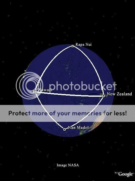
Of course, you could very well make any shape you damn like by picking the right islands to use, but on the other hand, who knows, maybe these Polynesian Triangles have a more complex history to them.
Great thread, by the way. Nan Madol is a very interesting, somewhat mysterious, and controversial location, and I would love to learn more about it.
I find the Polynesian Triangle really neat, but not in the sense that this triangular orientation of Hawaii, Rapa Nui, and New Zealand has any real intrinsic or historical significance, simply that I think it's cool that they, by chance, have such an obvious triangular orientation.
So anyway, as I said before I was wasting time, having fun with Google Earth and such, when I positioned the base of another triangle along the Hawaii/New Zealand edge of the Polynesian Triangle. Trying to match up the apex of the triangle with an island (any island, really), I came upon the ruins of Nan Madol, which make an (almost) perfect triangle with Hawaii/NZ.
Of course, you could very well make any shape you damn like by picking the right islands to use, but on the other hand, who knows, maybe these Polynesian Triangles have a more complex history to them.
Great thread, by the way. Nan Madol is a very interesting, somewhat mysterious, and controversial location, and I would love to learn more about it.
alexg,
So am I understanding this correctly - you did not get that out of some book or website? you noticed that by yourself? it is very interesting
The initial thought that pops into my head is Dragon Lines, aka The Grid, aka Ley Lines, aka The Earth Grid.
For those who dont know, Dragon Lines are literal lines of energy/power which flow through the earth. Major structures such as Giza Pyramids, Stonehenge, etc, etc (as well as most major churches) are built on Dragon Lines junctions or crossroads - where a bunch of these lines intersect.
Without any follow up research and writing off the top of my head i would think that this triangular formation formed by linking these islands could possibly be intentional.
If the Lemurians did build Nan Madol and if they did work as closely with nature as i and many other researchers in the field believe, then it would make perfect sense they that had knowledge of Dragon Lines and used them to determine the building sites of their temples.
I guess we need to determine if there are Dragon Lines in the same (or similar) places you drew the triangle.
If there isn't then i suppose it could be some kind of coincidence. If i have the time, which i doubt i will, i will try to put together a list of suspected Lemurian ruins and then plot them on a map and see if there is any correlation.
Anyway alexg, perhaps you should try doing similar things with Ayres Rock in Northern Territory, Australia. i have some bizzare ideas about that place and would be interested to see if it matches up (in a triangle type thing) to anything interesting. Also try doing the triangle thing with Yonaguni off the coast of Japan - the ruins there would almost have to be Lemurian. Could be interesting
Thanks for the response, srsen. No books or sources, just too much time on my hands on the weekend and a tendency to find patterns (where none may
exist).
It's funny you should bring up Yonaguni, because if you plot a line from the apex of the Madol/Hawaii/NZ triangle all the way around the earth to meet the apex of the Rapa/Hawaii/NZ triangle, Yonaguni (and some other interesting sites) are in rather close proximity to the extending line - probability explains that away rather quickly, but it's still kind of neat.
I had never considered the lay or Dragon lines as a factor, but that's certainly a possibility, I suppose. I'll try to have a look.
What I'm leaning toward, after a little research, is its potential connection with ancient navigational aids such as the Clandon Barrow Lozenge or some such thing.
Anyways, here's an interesting picture of all four sites connected. There are of course hundreds of small islands inside this lozenge shape, two of which, Pitcairn and its sister island Oeno, are almost equidistant from the Hawaii/NZ connecting line as is Nan Madol, so if you make a new triangle out of Pitcairn/Hawaii/NZ it comes out nearer to an actual rhombus than the Rapa/Hawaii/NZ triangle, which, as it is now, makes the whole shape look more like a shield or kite.
Alexg,
Very interesting idea there in regards to the Clandon Barrow Lozenge.
(This will make NO SENSE if you don’t read Alexg's Lozenge link…)
Am I to understand that what you are saying is that the ruins of Lemuria (ie: the past cities, temples, etc) were plotted to intentionally create Clandon Barrow Lozenge type outline when lines are drawn to link each of them? Meaning that the distance between each ruin and the adjacent angles from say Hawaii to Nan Madol would all be relevant and intentional and would tell of a particular measurement or important number and so on?
Fascinating stuff if that is what your saying. And who knows, that could be highly likely. It makes me think though, what important ruin would be found at the centre of the Lozenge???
I am going to forward this thread on to some Lemurian researchers and see what they make of this idea. I think that someone with enough time to plot all Lemurian ruins may be able to see if this idea holds any water. Great stuff mate!
Another point of interest here - when looking at how Plato described Atlantis, he described it has having concentric circles. (see below pics)
Could these circles have also been a reference to a Clandon Barrow Lozenge method of information storage? It is very possible. View the pic below - it is the lines of the Clandon Barrow Lozenge and then picture the same idea as overlapping Atlantis. Interesting
Anyway i would just to conclude by adding that I am still interested to hear people's thoughts on Nan Madol. I don’t want the thread to turn away from Nan Madol discussion entirely, so please keep it coming guys
Howdy Srens
Hans: Unfortunately there is no evidence for either the existence of Lemuria or the movement of unidentified people in that area.
Hans: To cover something up you need to know that it exists, no such evidence exists and if it did how did “they” get everyone to agree that x, y, z were to be ‘denied’, while a, b, c were acceptable – remember they would have had to have done this before the existence of radio-carbon and other age testing methodologies-even DNA-were know, so…so how did they do that?
Hans: History books tend to be written in support of existing evidence or commonly agreed speculation based on known evidence. There is no evidence for Lemuria, therefore it is not mentioned except as a continent proposed as a land link in the Indian ocean to explain how Lemur’s could be found in both India and Mad.
Hans: Incorrect no modern researcher other than good old Thor held that point of view, the Andean civilizations are not considered to have been the source of Polynesian culture. Most recent evidence points to the Polynesians reaching SA however. As an aside are you forgetting quipos,/khipu? So they didn’t conveniently forget anything!
Hans: “Cyclopean walls”? Sorry I don’t recall these Srsen care to tell us where they are located on Rapa Nui? Needless to say they don’t date older than Cuzco.
Hans: Really? I think you’d have a hard time convincing the Polynesians and Andean cultures and those who know their culture of this. I recommend you go to the Hall of Ma’at and float that idea. They have some Polynesian/Melanesian experts there.
Hans: Being personally incredulous of the abilities of other people doesn’t become a fact against its reality, 25+ tons were moved by many cultures at many times before mechanization – floating it is a LOT easier than moving it by land.
I don’t think you intended it but that is a bit dismissive and might even be considered a tad racist. Like saying the stupid peasant living on the Nile couldn’t move heavy rocks (they could). The people on Rapa Nui had no problems moving statues of that weight.
Continuing on the next reply
[edit on 23-10-2007 by Hanslune]
Lemuria was very possibly developing either at the same time as these “Polynesians” or already established while these movements were going on.
Hans: Unfortunately there is no evidence for either the existence of Lemuria or the movement of unidentified people in that area.
We also have to consider that, for whatever reason, Lemuria has been covered up, denied.
Hans: To cover something up you need to know that it exists, no such evidence exists and if it did how did “they” get everyone to agree that x, y, z were to be ‘denied’, while a, b, c were acceptable – remember they would have had to have done this before the existence of radio-carbon and other age testing methodologies-even DNA-were know, so…so how did they do that?
Of course a standard history book won’t contain information on the movements and history of the Lemurian people, but it will certainly tell us all bout everything else.
Hans: History books tend to be written in support of existing evidence or commonly agreed speculation based on known evidence. There is no evidence for Lemuria, therefore it is not mentioned except as a continent proposed as a land link in the Indian ocean to explain how Lemur’s could be found in both India and Mad.
“It is believed by mainstream researchers that the ancient Andeans introduced civilisation to Easter Island, however what they have all conveniently forgotten is that the Andeans did not possess a written language”
Hans: Incorrect no modern researcher other than good old Thor held that point of view, the Andean civilizations are not considered to have been the source of Polynesian culture. Most recent evidence points to the Polynesians reaching SA however. As an aside are you forgetting quipos,/khipu? So they didn’t conveniently forget anything!
Additionally, the Cyclopean walls at Easter Island are older than their Cuzco (Andean) counterparts.
Hans: “Cyclopean walls”? Sorry I don’t recall these Srsen care to tell us where they are located on Rapa Nui? Needless to say they don’t date older than Cuzco.
The Pre-Inca Uru of Lake Titicaca, the ancestral Polynesian Uru-keu and Easter Island’s Uru do not prove one people’s influence over another, but rather that they were all influenced by an external power, referred to by some Polynesians as Uru – another name for the Pacific Motherland, or Lemuria.
Hans: Really? I think you’d have a hard time convincing the Polynesians and Andean cultures and those who know their culture of this. I recommend you go to the Hall of Ma’at and float that idea. They have some Polynesian/Melanesian experts there.
…
Wait a second – some of the magnetised basalt blocks were upwards of 25 tonnes each
Hans: Being personally incredulous of the abilities of other people doesn’t become a fact against its reality, 25+ tons were moved by many cultures at many times before mechanization – floating it is a LOT easier than moving it by land.
“Island natives could not perform the task”.
I don’t think you intended it but that is a bit dismissive and might even be considered a tad racist. Like saying the stupid peasant living on the Nile couldn’t move heavy rocks (they could). The people on Rapa Nui had no problems moving statues of that weight.
Continuing on the next reply
[edit on 23-10-2007 by Hanslune]
new topics
-
University of Texas Instantly Shuts Down Anti Israel Protests
Education and Media: 1 hours ago -
Any one suspicious of fever promotions events, major investor Goldman Sachs card only.
The Gray Area: 3 hours ago -
God's Righteousness is Greater than Our Wrath
Religion, Faith, And Theology: 8 hours ago -
Electrical tricks for saving money
Education and Media: 11 hours ago
top topics
-
VP's Secret Service agent brawls with other agents at Andrews
Mainstream News: 12 hours ago, 10 flags -
Cats Used as Live Bait to Train Ferocious Pitbulls in Illegal NYC Dogfighting
Social Issues and Civil Unrest: 16 hours ago, 8 flags -
Nearly 70% Of Americans Want Talks To End War In Ukraine
Political Issues: 13 hours ago, 4 flags -
Sunak spinning the sickness figures
Other Current Events: 13 hours ago, 4 flags -
Electrical tricks for saving money
Education and Media: 11 hours ago, 4 flags -
Late Night with the Devil - a really good unusual modern horror film.
Movies: 15 hours ago, 2 flags -
Any one suspicious of fever promotions events, major investor Goldman Sachs card only.
The Gray Area: 3 hours ago, 2 flags -
University of Texas Instantly Shuts Down Anti Israel Protests
Education and Media: 1 hours ago, 1 flags -
God's Righteousness is Greater than Our Wrath
Religion, Faith, And Theology: 8 hours ago, 0 flags
active topics
-
University of Texas Instantly Shuts Down Anti Israel Protests
Education and Media • 6 • : CriticalStinker -
Sunak spinning the sickness figures
Other Current Events • 14 • : Ohanka -
British TV Presenter Refuses To Use Guest's Preferred Pronouns
Education and Media • 147 • : Annee -
Nearly 70% Of Americans Want Talks To End War In Ukraine
Political Issues • 41 • : andy06shake -
New whistleblower Jason Sands speaks on Twitter Spaces last night.
Aliens and UFOs • 56 • : pianopraze -
So this is what Hamas considers 'freedom fighting' ...
War On Terrorism • 260 • : network dude -
Hate makes for strange bedfellows
US Political Madness • 43 • : network dude -
Any one suspicious of fever promotions events, major investor Goldman Sachs card only.
The Gray Area • 7 • : seekshelter -
-@TH3WH17ERABB17- -Q- ---TIME TO SHOW THE WORLD--- -Part- --44--
Dissecting Disinformation • 663 • : MetalThunder -
Russia Ukraine Update Thread - part 3
World War Three • 5731 • : Freeborn