It looks like you're using an Ad Blocker.
Please white-list or disable AboveTopSecret.com in your ad-blocking tool.
Thank you.
Some features of ATS will be disabled while you continue to use an ad-blocker.

Map-making highlights impact of climate change
page: 11
share:
ABC News
It has been four years since the last edition of The Times Comprehensive Atlas of the World, and cartographers say they have had to redraw coastlines and reclassify land to reflect significant geographical changes since then.
The atlas's editor-in-chief says the new maps will let us see environmental disasters unfolding before our eyes.
Read more
Please visit the link provided for the complete story.
Haven't seen this come up when I searched ATS. Thought I'd put it on here.
Cheers
[edit]
Here are some scans comparing the old and new editions taken from bartholomewmaps.com.
Disintegration of Larsen Ice Shelf, Antarctica
1967
2003
(rotated for better comparison. Original)
Shrinking of Aral Sea, Asia
1967
2003
Iraqi marshlands destroyed, Asia
1999
2003
Lake Chad reduced by almost 95%, Africa
1973
2003
Creation of Three Gorges Dam, China
1997
2003
[edit on 18/9/2007 by David2012]
The Aral Sea located between Uzbekistan and Kazakhstan is now approximately 10% of its former size.
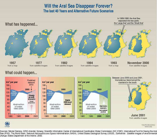
www.unep.org...
Lake Chad, which used to straddle the borders of Chad, Cameroon, Nigeria, and Niger, is now approximately 6% of its former size.
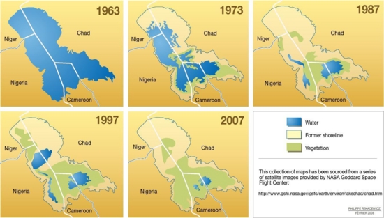
www.unep.org...
www.unep.org...
Lake Chad, which used to straddle the borders of Chad, Cameroon, Nigeria, and Niger, is now approximately 6% of its former size.
www.unep.org...
new topics
-
When an Angel gets his or her wings
Religion, Faith, And Theology: 41 minutes ago -
Comparing the theology of Paul and Hebrews
Religion, Faith, And Theology: 1 hours ago -
Pentagon acknowledges secret UFO project, the Kona Blue program | Vargas Reports
Aliens and UFOs: 2 hours ago -
Boston Dynamics say Farewell to Atlas
Science & Technology: 2 hours ago -
I hate dreaming
Rant: 3 hours ago -
Man sets himself on fire outside Donald Trump trial
Mainstream News: 5 hours ago -
Biden says little kids flip him the bird all the time.
Politicians & People: 5 hours ago -
The Democrats Take Control the House - Look what happened while you were sleeping
US Political Madness: 5 hours ago -
Sheetz facing racial discrimination lawsuit for considering criminal history in hiring
Social Issues and Civil Unrest: 5 hours ago -
In an Historic First, In N Out Burger Permanently Closes a Location
Mainstream News: 7 hours ago
1