It looks like you're using an Ad Blocker.
Please white-list or disable AboveTopSecret.com in your ad-blocking tool.
Thank you.
Some features of ATS will be disabled while you continue to use an ad-blocker.

Mysterious "Missing" Earthquakes
page: 11
share:
Is the USGS conveniently hiding earthquake data from the masses?
This concerns California earthquake data recently. Many 'missing'
quakes and revised quake data. This concerned citizen has been
following this information and documented it below.
What could this mean? Simple errors or mistakes or something else?
From website: standeyo.com...
[edit on 6/10/2007 by greatlakes]
This concerns California earthquake data recently. Many 'missing'
quakes and revised quake data. This concerned citizen has been
following this information and documented it below.
What could this mean? Simple errors or mistakes or something else?
From website: standeyo.com...
DELETED AND REVISED DATA from the USGS site:
DELETED
USGS ENS 10:44 AM 1 DELETED 2007-05-31 09:44 (M 3.0) NORTHERN CALIFORNIA 42.0
USGS ENS 10:45 AM 1 DELETED 2007-05-31 09:44 (M 3.0) NORTHERN CALIFORNIA 42.0
USGS ENS 10:45 AM 1 DELETED 2007-05-31 09:44 (M 2.8) NORTHERN CALIFORNIA 41.6
USGS ENS 10:46 AM 1 DELETED 2007-05-31 09:44 (M 3.4) NORTHERN CALIFORNIA 42.0
USGS ENS 10:46 AM 1 DELETED 2007-05-31 09:44 (M 3.4) NORTHERN CALIFORNIA 42.0
USGS ENS 10:47 AM 1 DELETED 2007-05-31 09:45 (M 2.5) NORTHERN CALIFORNIA 41.9
USGS ENS 11:46 AM 1 DELETED 2007-05-31 10:46 (M 2.1) SOUTHERN CALIFORNIA 34.9
REVISED
USGS ENS 12:17 PM 2 2007-05-28 12:49 REVISED: (Ml 1.1) SOUTHERN CALIFORNIA 35.6
USGS ENS 10:23 AM 2 2007-05-29 04:08 REVISED: (Ml 0.5) SOUTHERN CALIFORNIA 33.5
USGS ENS 10:25 AM 2 2007-05-29 04:44 REVISED: (M 1.0) SOUTHERN CALIFORNIA 33.6
USGS ENS Wed., 10:51 PM 2007-05-31 04:48 REVISED: (Mcd 2.1) CENTRAL CALIFORNIA 36.3
USGS ENS 12:25 AM 2 2007-05-31 04:57 REVISED: (Ml 2.5) NORTHERN CALIFORNIA 41.9
USGS ENS 2:38 PM 2 2007-05-31 19:57 REVISED: (Ml 2.1) SOUTHERN CALIFORNIA 34.8
USGS ENS 10:51 PM 2 2007-05-31 04:48 REVISED: (Mcd 2.1) CENTRAL CALIFORNIA 36.3
June 2, 2007
Holly Deyo
No less than seven earthquake events were mysteriously removed by USGS on Thursday. Another seven events were revised downward. All events just happened to take place in California. That's an awful lot of "mistakes".
If the quakes had all occurred in relatively the same place, it might be attributable to a faulty monitor. However, these EQ events transpired throughout the state.
Coincidentally, a magnitude 4.2 shaker struck Southern California yesterday.
Keep in mind that the Bush administration is requiring scientists' papers to be vetted before release to the public — information that would keep the public informed about events that can greatly affect our well-being. In accordance with this policy, there is a general "pushing downing" and silencing of information regarding natural disasters and climate change.
It is NOT better to be kept in the dark; it only leaves people vulnerable and unprepared.
[edit on 6/10/2007 by greatlakes]
I wonder if they were shockwaves caused by military, building demolition, or mining explosives ?
Have you contacted them directly and asked for an explanation ?
Have you contacted them directly and asked for an explanation ?
Originally posted by sy.gunson
I wonder if they were shockwaves caused by military, building demolition, or mining explosives ?
Have you contacted them directly and asked for an explanation ?
I see a 3.4 , Im not sure but if that was an explosion it was a big one.
We used to get 3.0 or so earthquakes out in Hawaii all the time. They eventually found out they were sonic booms from military planes that were less
than 150 miles off shore. They were just big enough that glasses on shelves would rattle, but you couldn't feel them.
I have not emailed the USGS yet concerning the missing ones. The revised ones are interesting as well...
One cause for the missing ones (really we should be calling them deleted) would be possible mine blasting, quarries etc, sonic booms...But shouldnt these deleted and revised USGS earthquakes BE DOCUMENTED in some way on the website. Any serious gov't agency would/should document an error, either with calibration, false signals, revised magnitudes, locations and depths etc. Hmmmm, interestinger & interestinger...
Did a google search for this and came up with something of interest (yeah its from Rense, but seems genuine and documented, need to followup on this...)
The Case Of The
Missing Wyoming Earthquake
[edit on 6/10/2007 by greatlakes]
One cause for the missing ones (really we should be calling them deleted) would be possible mine blasting, quarries etc, sonic booms...But shouldnt these deleted and revised USGS earthquakes BE DOCUMENTED in some way on the website. Any serious gov't agency would/should document an error, either with calibration, false signals, revised magnitudes, locations and depths etc. Hmmmm, interestinger & interestinger...
Did a google search for this and came up with something of interest (yeah its from Rense, but seems genuine and documented, need to followup on this...)
The Case Of The
Missing Wyoming Earthquake
When the 5.3 showed up, Mitch Battros got involved. What he did not know at the time was that the 5.3 EQ had INDEED been read by the USGS and the European site he found it on, had actually linked directly to that very USGS report.
2004/02/06 19:03:33.3 43.5N 105.1W 264 mb5.3 A NEIA WYOMING
[edit on 6/10/2007 by greatlakes]
Very interesting. I don't know what it means, if anything, but interesting nevertheless.
And on a lighter note: The new avatar is not good. You shouldn't put a picture of me up without my permission.
And on a lighter note: The new avatar is not good. You shouldn't put a picture of me up without my permission.
This is very interesting.
Perhaps there is a simple explanation? = the mining and military blasts but why not leave it there and state what it is? Perhaps it would then fall into a security breach issue?
Seems very odd.
Perhaps there is a simple explanation? = the mining and military blasts but why not leave it there and state what it is? Perhaps it would then fall into a security breach issue?
Seems very odd.
Yes the northern California ones that were deleted seem indicative of a controlled blast detonation cycle, very close proximity time wise to each
other and a large magnitude.
What is at the location of the USGS earthquake epicenter, either above of below the epicenter. I believe the "42.0" gives us the latitude.. of the location? And its rounded off I believe as well.
Goto here for USGS search of a particular area, narrow the dates down...etc:
earthquake.usgs.gov...
or here for different search types:
www.ncedc.org...
And BTW, the USGS search does account for other events, such as nuclear or quarry type blasts in the seismic readings...see here:
[edit on 6/10/2007 by greatlakes]
What is at the location of the USGS earthquake epicenter, either above of below the epicenter. I believe the "42.0" gives us the latitude.. of the location? And its rounded off I believe as well.
Goto here for USGS search of a particular area, narrow the dates down...etc:
earthquake.usgs.gov...
or here for different search types:
www.ncedc.org...
And BTW, the USGS search does account for other events, such as nuclear or quarry type blasts in the seismic readings...see here:

[edit on 6/10/2007 by greatlakes]
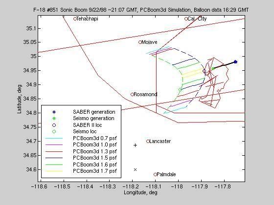
If they were from sonic booms then there would be no reason to keep them on the list. California is home to Edwards AFB, and the NASA Dryden Flight
Center. They have a lot of interesting craft doing flight tests right now.
Originally posted by Zaphod58
If they were from sonic booms then there would be no reason to keep them on the list. California is home to Edwards AFB, and the NASA Dryden Flight Center. They have a lot of interesting craft doing flight tests right now.
Possibly, however, sonic booms are more localized to smaller areas on the ground and also have specific patterns that the USGS should have set 'patterns' of detection filters to distinguish between sonic booms, quarry events (they have searchable database for theses events) as well as nuclear blasts.
From USGS search engine, options for quarry and nuclear events...
Map of aircraft trajectory, locations where boom was launched, wavefronts at arrival, and pressure contours.
* No boom is predicted in Lancaster or Palmdale, where it was heard at locations + and x.
* Low values of pressure bunch up to the north, but not the south.
[edit on 6/10/2007 by greatlakes]
So what's the conspiracy? I'm not saying there isn't one, or that USGS isn't hiding info, but I am not sure if I am following this to the
conspiracy the OP intended.
Greatlakes you pulled the data off the USGS site and it was marked deleted. So at least them deleting the quake data is public knowledge right? Did they give an explanation for why they were removed? What about last month, and the month before? Is there a consistent history of removing/deleting quake data?
[edit on 11-6-2007 by Cloak and Dagger]
Originally posted by Cloak and Dagger
Greatlakes you pulled the data off the USGS site and it was marked deleted. So at least them deleting the quake data is public knowledge right? Did they give an explanation for why they were removed? What about last month, and the month before? Is there a consistent history of removing/deleting quake data?
Don't know if there is one definitively, hence the discussion. I've looked for the data on the USGS site, cannot find it under the search engines there. The orig. data came from the linked site...I'll try to call the website ownere and dig around some more as I've been doing...As far as an offered explanation from USGS, nada so far...
[edit on 6/11/2007 by greatlakes]
Has anyone explored the possibility of off-shore seismic activity? Perhaps the result of sonic weaponry testing by submarines?
This is actually a stab in the dark, and frankly, I'm not sure searching even this forum for posts on Navy "earthquake weaponry" will be a happy rabbit hole to jump down into.
Just curious. Anyone?
This is actually a stab in the dark, and frankly, I'm not sure searching even this forum for posts on Navy "earthquake weaponry" will be a happy rabbit hole to jump down into.
Just curious. Anyone?
Originally posted by newtron25
Has anyone explored the possibility of off-shore seismic activity? Perhaps the result of sonic weaponry testing by submarines?
This is actually a stab in the dark, and frankly, I'm not sure searching even this forum for posts on Navy "earthquake weaponry" will be a happy rabbit hole to jump down into.
Could be, but the seismographs record the location, the epicenter when doing the recordings, as well as the depth...
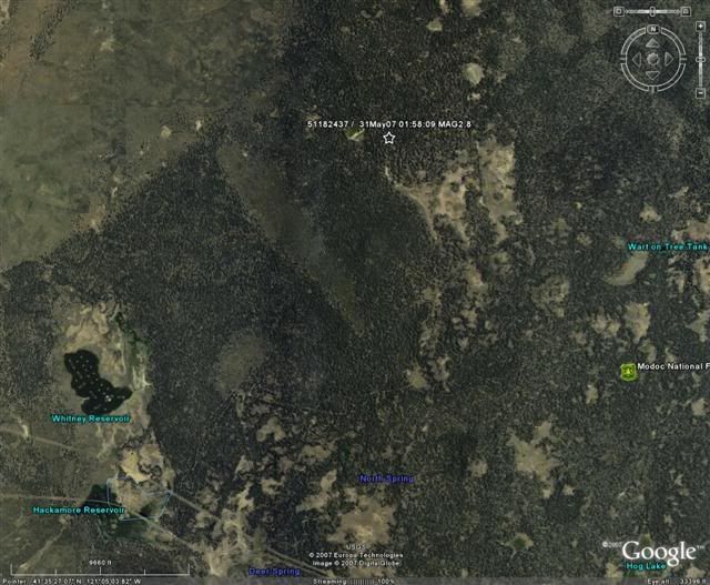
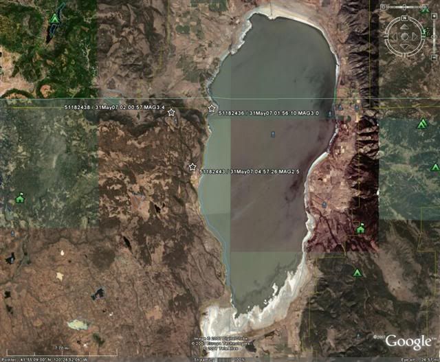
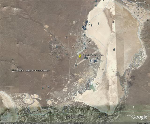
I have done some more investigating into this topic, I've contacted the website owner for more information...She gave me some more information that wasnt on the website such as lat/long of the events (5 of them that she had). These are the deleted events (five of seven).
Its interesting to note that the events are NOT found on the USGS search for the event id #'s or the location or the time when doing a search there. No explanation for the events being deleted is mentioned either.
I have mapped the 5 events on GE...and here is the raw data:
41.993N, 120.493W 51182436 31May07 01:56:10 MAG3.0 DELETED
41.614N, 121.078W 51182437 31May07 01:58:09 MAG2.8 DELETED
41.989N, 120.548W 51182438 31May07 02:00:57 MAG3.4 DELETED
41.934N, 120.519W 51182443 31May07 04:57:26 MAG2.5 DELETED
34.890N, 118.020W 10251041 31May07 16:13:05 MAG2.1 DELETED
These are sizable quakes, around 3.0 magnitude, recorded by different stations, and at different times, the deleted quakes all centering around one day.
Here is the mapping of the events:
[edit on 6/11/2007 by greatlakes]
new topics
-
Russian intelligence officer: explosions at defense factories in the USA and Wales may be sabotage
Weaponry: 1 hours ago -
African "Newcomers" Tell NYC They Don't Like the Free Food or Shelter They've Been Given
Social Issues and Civil Unrest: 2 hours ago -
Russia Flooding
Other Current Events: 4 hours ago -
MULTIPLE SKYMASTER MESSAGES GOING OUT
World War Three: 4 hours ago -
Two Serious Crimes Committed by President JOE BIDEN that are Easy to Impeach Him For.
US Political Madness: 5 hours ago -
911 emergency lines are DOWN across multiple states
Breaking Alternative News: 5 hours ago -
Former NYT Reporter Attacks Scientists For Misleading Him Over COVID Lab-Leak Theory
Education and Media: 7 hours ago -
Why did Phizer team with nanobot maker
Medical Issues & Conspiracies: 8 hours ago -
Pro Hamas protesters at Columbia claim hit with chemical spray
World War Three: 8 hours ago -
Elites disapearing
Political Conspiracies: 10 hours ago
top topics
-
Go Woke, Go Broke--Forbes Confirms Disney Has Lost Money On Star Wars
Movies: 12 hours ago, 13 flags -
Pro Hamas protesters at Columbia claim hit with chemical spray
World War Three: 8 hours ago, 11 flags -
Elites disapearing
Political Conspiracies: 10 hours ago, 9 flags -
Freddie Mercury
Paranormal Studies: 12 hours ago, 7 flags -
Nirvana - Immigrant Song
Music: 17 hours ago, 5 flags -
A Personal Cigar UFO/UAP Video footage I have held onto and will release it here and now.
Aliens and UFOs: 10 hours ago, 5 flags -
African "Newcomers" Tell NYC They Don't Like the Free Food or Shelter They've Been Given
Social Issues and Civil Unrest: 2 hours ago, 5 flags -
Two Serious Crimes Committed by President JOE BIDEN that are Easy to Impeach Him For.
US Political Madness: 5 hours ago, 5 flags -
911 emergency lines are DOWN across multiple states
Breaking Alternative News: 5 hours ago, 4 flags -
Former NYT Reporter Attacks Scientists For Misleading Him Over COVID Lab-Leak Theory
Education and Media: 7 hours ago, 4 flags
active topics
-
Russian intelligence officer: explosions at defense factories in the USA and Wales may be sabotage
Weaponry • 20 • : newstip -
Mood Music Part VI
Music • 3051 • : BrucellaOrchitis -
I Guess Cloud Seeding Works
Fragile Earth • 21 • : BrucellaOrchitis -
Elites disapearing
Political Conspiracies • 20 • : HerbertWest -
What Time is it on the Moon ?
Space Exploration • 50 • : wildespace2 -
Why did Phizer team with nanobot maker
Medical Issues & Conspiracies • 6 • : annonentity -
Israel ufo shoot down drones?
Aliens and UFOs • 26 • : GENERAL EYES -
African "Newcomers" Tell NYC They Don't Like the Free Food or Shelter They've Been Given
Social Issues and Civil Unrest • 4 • : GENERAL EYES -
The Acronym Game .. Pt.3
General Chit Chat • 7722 • : bally001 -
Two Serious Crimes Committed by President JOE BIDEN that are Easy to Impeach Him For.
US Political Madness • 7 • : Disgusted123
1