It looks like you're using an Ad Blocker.
Please white-list or disable AboveTopSecret.com in your ad-blocking tool.
Thank you.
Some features of ATS will be disabled while you continue to use an ad-blocker.

Pentagon "NTSB animation" is wrong!
page: 7share:
Originally posted by Zaphod58
Although some of that may have been true prior to 1960 all airplanes since then use a FADC Flight Air Data Compter system which has gotten better and better over the past 40 years. None of that would have been applicable to the Boeing 757.
Compass errors can be caused by turbulence, acceleration/deceleration, climbing/descending, turning, etc. So it's possible that if they were climbing during this time the compass would read off while the plane was heading the correct direction.
Although some of that may have been true prior to 1960 all airplanes since then use a FADC Flight Air Data Compter system which has gotten better and better over the past 40 years. None of that would have been applicable to the Boeing 757.
Originally posted by coughymachine
A flight level is an altitude. The Terminology Flight Level begins at 18,000 feet and refers to the fact that the Alitmeter setting above 18,000 is referenced to 29.92 (Standard Pressure) and not local barometric. Flight Level 270 is 27,000 feet.
Yes, as soon as the airspace is cleared in front of the aircraft the highest level requested is given. If he has requested 350 but it is only clear of traffic to 310 he is given only 310 until the conflicting traffic is clear.
Pilots want to climb as quickly as possible to save fuel. If a certain altitude is not immediately available center will give the airplane a slight turn to avoid the conflicting traffic so that he can still continue his climb.
Probably for weight. Pilots like to climb as high as possible to save fuel. However because of higher than normal outside air temperatures they may have to maintain a lower altitude until they burn off some fuel.
He was cleared direct Henderson at 12:37:31. It probably took him a couple of minutes to find Henderson in the database, put it in the FMS and then put it into DIRECT TO. Then the airplane starts the turn to Henderson at 12:39:09, 1 minute and 38 seconds after he was cleared to Henderson.
Fairly fast compliance for some of the pilots I know.
Is this routine as well? At 12:25:57, Sector 5 Radar (O5R) instructs FL77 to ‘climb and maintain flight level two seven zero’. What does this ‘two seven zero’ refer to? Is it altitude or heading?
A flight level is an altitude. The Terminology Flight Level begins at 18,000 feet and refers to the fact that the Alitmeter setting above 18,000 is referenced to 29.92 (Standard Pressure) and not local barometric. Flight Level 270 is 27,000 feet.
I’m assuming the former. But FL77 was still around 13,000, having not even reached the altitude given to it by NH two minutes earlier at 12:23:47 (17,000). Is this major overlapping of altitude instructions typical?
Yes, as soon as the airspace is cleared in front of the aircraft the highest level requested is given. If he has requested 350 but it is only clear of traffic to 310 he is given only 310 until the conflicting traffic is clear.
But the one that seems most odd is this.
Sector 3 Radar (O3R) makes its first communication with FL77 at 12:31:21. It instructs FL77 to ‘climb maintain level flight two niner zero’. FL77 is heading 278 degrees at the time. Nearly three minutes later (why the delay?), at 12:34:14, O3R instructs FL77 to ‘turn twenty degrees right vector for your climb’. FL77 executes the manoeuvre and ends up heading 298 degrees.
Pilots want to climb as quickly as possible to save fuel. If a certain altitude is not immediately available center will give the airplane a slight turn to avoid the conflicting traffic so that he can still continue his climb.
Now here’s what I don’t understand. First, O3R makes a mistake in its instruction at 12:37:31. It says:
American seventy seven recleared direct Charleston climb maintain cor – correction recleared direct Henderson sir climb maintain flight level three niner zero.
At 12:37:39 FL77 requests ‘three five zero as final’ (why would he request that?) and had to repeat the request at 12:37:55.
Probably for weight. Pilots like to climb as high as possible to save fuel. However because of higher than normal outside air temperatures they may have to maintain a lower altitude until they burn off some fuel.
Whilst this exchange is happening, FL begins a left turn as it continues to climb. At 12:39:09, FL77 is heading at 272 degrees – a change of 26 degrees. O3R did not request this and FL77 did not announce it. They just did it. If the earlier 'spontaneous' 8/9 degree adjustment was okay, what about this 26 degree one?
He was cleared direct Henderson at 12:37:31. It probably took him a couple of minutes to find Henderson in the database, put it in the FMS and then put it into DIRECT TO. Then the airplane starts the turn to Henderson at 12:39:09, 1 minute and 38 seconds after he was cleared to Henderson.
Fairly fast compliance for some of the pilots I know.
Here is how we know for sure that at least part of the FDR data was faked.
The flight data reorder records the airplanes altitude to a Standard Pressure reference of 29.92 inches of mercury. This is the same Standard Pressure that is used above 18,000 feet.
Now the reason the flight data recorder records the airplanes altitude at 29.92 is that it would be too difficult to measure each of the other two altimeters to the current setting (local field barometric) and in case of an accident to try and reduce the data to one figure.
So the master altitude recorded is based on an altimeter setting of 29.92 and after an accident this ‘master’ altitude is compared to the two other altimeters, corrected to local barometric, for comparison.
There is a third altimeter called a ‘standby’ altimeter but I don’t think the data from this altimeter is recorded.
In others words if the airplane crashes into the ground the flight data recorder is recording that crash altitude in reference to 29.92 inches of Mercury, NOT TO LOCAL FIELD BAROMETRIC.
The pilots and co-pilots altimeter will be set to local field barometric and the flight data recorder will be recording what those altimeters are set to in terms of barometric pressure NOT ALTITUDE.
All the accident investigators have to do is convert the Flight Data Recorder altitude (recorded at Standard Pressure of 29.92) to the barometric pressure set on pilots and copilots altimeter to find out the altitude that the pilots were reading at the instant of the crash.
Now, if you look at the Flight Data Recorder tabulated data for Flight 77 you will see that on line 37806, the last line of recorded data for Pressure Altitude, that under Column E (which records Pressure Altitude, that altitude recorded at 29.92 inches of Mercury Hg) is the figure 173, meaning 173 feet. Further along the recorded tabulated data under column CG is the figure 30.24 which is the barometric pressure set on the pilot’s altimeter. This column is titled BARO CO No. 1 IN in. Hg. Next to this figure on the right is Column CH, titled BARO CO No.2 IN in. Hg. And the figure there is 30.23.
This means that the Captains (No.1) altimeter was set to 30.24 and the Co-pilots (No.2) altimeter was set to 30.23.
Now to correct the altitude at which the Flight Data Recorder recorded the aircraft crashed, 173 feet, to the real altitude of the crash and that altitude displayed on the Pilots and Co-Pilots altimeter you have to convert 173 feet recorded at 29.92 to the local barometric pressure set on the altimeter, in the case of the Captains altimeter, 30.24.
We know that each inch of mercury is equal to 1000 feet and that each 1/100 is 10 feet of altitude. So the difference between 29.92 and 30.24 is 32/100 so 32 times 10 is 320 feet. So we add 320 feet to Flight Data Recorded Altitude recorded at 29.92 of 173 feet and we get 493 feet. That means that the final altitude recorded by the Flight Data Recorder of Flight 77 was 493 feet or approximately 400 feet above the Pentagon.
493 feet is considerably higher than the very top of the Pentagon (at least 400 higher) therefore whatever airplane this Flight Data Recorder tabulated data came from did not hit the Pentagon or the data was faked.
It is my understanding from correspondence I have seen from the NTSB is that the NTSB did not prepare the tabular data. They (NTSB) claim that everything was turned over to the FBI.
It is possible that the FBI faked the data and in doing so did not realize that PRESSURE ALTITUDE meant altitude that was recorded at 29.92 inches of mercury and that when they put in 173 feet as the crash altitude box (37806 column E) that the figure was erroneous. Non-experts would believe that the figure in box 37806 represented that actual altitude of the airplane at the time of the crash. However experts would know that if that figure of 173 on 37806 column E (Pressure Altitude) was correct then it meant that the aircraft overflew the Pentagon by over 400 feet.
It is also possible that they went back a few minutes in the tabular data and started changing the figures in Column E to ‘altitude above sea level’ or the altitude that the cockpit altimeters would have been reading. They may have done that so that nobody (except experts) would have been confused about what altitude the FBI wanted people to think the airplane was actually at.
But whatever the FBI did or did not do with the tabular data from the FDR, no Boeing 757 crashed into the Pentagon on 911. And that is an iron-clad fact.
Originally posted by jprophet420
the arguement only faded away if you let it man. there has been much debunking on both sides that have gone on and on but several things have never been debunked. the main topics in my eyes for the pentagon story is that if you look at the footage in chronological order there was no hole in the pentagon to house a jetliner, and that the fuel that would have been in a jetliner would have burned for days.
This is from In Plane Site I guess. So obviously the issue has not gone away. This animation has been helping fuel the baseless no-planes arguments. I explain the entry hole here that was 90 feet wide and about 30 high at its high spot. Pretty damn close actually for an airliner 125 feet across and 44 feet high.
My physical evidence list
Originally posted by johnlear
Moreover according to the tabular FDR BOTH altimeters were reset within 1 second of each other.
Welcome to the thread Mr. Lear. My questions would be about as Nick's.
Originally posted by nick7261
how does anybody know if this data is real?
And as a member of PF911T, how do you address the primary issues which were brought up in this thread?
So thank you Nick.
Now to read the response, so thank you Mr. Lear.
Wherever we're getting here it's somewhere.
Originally posted by johnlear
But whatever the FBI did or did not do with the tabular data from the FDR, no Boeing 757 crashed into the Pentagon on 911. And that is an iron-clad fact.
John,
With all due respect, there seems to be a bit of circular illogic to your reasoning. If the FDR data is not trustworthy, then how can the data that it portrays be used to argue that there was no 757 that crashed into the Pentagon?
I.e., if the FDR shows the plane at 400 ft. at the end of the data file, then obviously the plane didn't hit the Pentagon, and therefore the FDR data was truncated prematurely. This leads to the conclusion that the FDR data was manipulated. And if the FDR data was manipulated, then how can it be used to show the plane was really at 400 ft.?
Also, what about the NTSB animation? Is it really from the NTSB or did snowygrouch create it to sell some DVDs? As a member of PF911T, do you know why it wasn't pointed out that the csv file didn't match the animation?
This is more evidence of a conspiracy than the *content* of either the animation or the csv file. If the animation and csv file both came from the NTSB, and they didn't match, then the big story should have been that the NTSB provided internally inconsistent data (either the csv or the animation had to be fake!).
It makes no sense to me that if PF911T knew that the NTSB provided either a faked animation or a faked csv file why they would make the story about the flight path instead of making the story about the fact that the NTSB data was internally inconsistent.
This would have been THE smoking gun of government fraud if only there was a documented chain of evidence proving the animation actually came from the NTSB.
Originally posted by johnlear
Here is how we know for sure that at least part of the FDR data was faked.
the basic re-set stuff but explained better...
There is a third altimeter called a ‘standby’ altimeter but I don’t think the data from this altimeter is recorded.
Indeed not too much to go on. I lokked at the PDF from the NTSB and see 13 pages of parameter listings, 4 of those plotted, 9 of those not functioning or validated. This includes radio altimeter among others. This seems to be the case with the CSV file too, lots of empty commas...
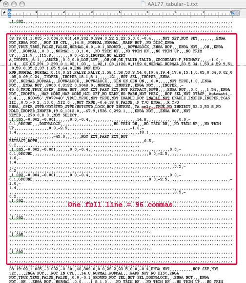
Re: your graph reading. When I see you mention columns and whatnot, I presume you mean you've gotten the CSV file (AA77 tabular) to open readably. If so is there a way to share this? Or just the last frame of data anyway? What I have is plain text and a frame looks like this:
Still assessing where the Q and A stand on the main issues, re: the animation. I'll be back in 20 min...
Originally posted by Caustic Logic
Re: your graph reading. When I see you mention columns and whatnot, I presume you mean you've gotten the CSV file (AA77 tabular) to open readably. If so is there a way to share this? Or just the last frame of data anyway? What I have is plain text and a frame looks like this:
I've always been able to get the file to open in Excel. If you don't have Excel, I'm pretty sure you can download the open source spreadsheet that opens Excel files.
It's at:
www.openoffice.org...
Originally posted by nick7261
Getting back on topic, how does anybody know if this data is real?
And as a member of PF911T, how do you address the primary issues which were brought up in this thread?
The Pandora's Black Box video portrays the NTSB animation as showing the flight path north of the Citgo and with a problematic altitude. And the FDR csv file clearly shows the flight path matching up with the official story.
Originally posted by johnlear
It is my understanding from correspondence I have seen from the NTSB is that the NTSB did not prepare the tabular data. They (NTSB) claim that everything was turned over to the FBI.
It is possible that the FBI faked the data and in doing so did not realize that PRESSURE ALTITUDE meant altitude[…] However experts would know that if that figure of 173 on 37806 column E (Pressure Altitude) was correct then it meant that the aircraft overflew the Pentagon by over 400 feet.
So the FBI doctored the data
Luckily we have such an expert right here.
so that nobody (except experts) would have been confused about what altitude the FBI wanted people to think the airplane was actually at.
1)My understanding was the NTSB turned the FDR over to the FBI, who controlled it but then sent it back to the NTSB to extract the data. Then indeed, the FBI re-took possession of it and could possibly have altered it, certainly with expert advice I should think IMO to prevent slip-ups like this. But who knows?
2) I’m not sure why the FBI wanted people to think the plane was 173 feet above MSL, 140 feet above the ground, when all official reports have it about 10-20 feet up in its second to last second? Wouldn’t they have faked a number like 15? Then you guys would be stumbling on the fact that it overflew the Pgon by 250 feet. I dunno. Something else is up here.
3) So the issue is that the 400'+ overflight is proven internally by the numbers in the FDR data. Again, I still have questions about even this file we're working off of. And it’s off the point. This is a case that some data at least was altered, and the implication for the subject at hand is that the animation may be right while the FDR data – and the physical evidence - are off. But you haven’t explicitly addressed this yet. Is the animation some sort of holy grail nearer the FDR than all the others, but too mysterious to explain?
Originally posted by nick7261Yet nowhere in the video, and nowhere that I've seen in the promotion of PBB or PentaCon, is it brought up that the csv file matches the official story, but not the animation. In fact, the impression I got was that the animation was created *from* the FDR csv file.
Originally posted by johnlear
-
Originally posted by nick7261At this point, unless there's some explanation forthcoming about the source of the animation video, everything points to the animation video as being bogus.
Originally posted by johnlear
But whatever the FBI did or did not do with the tabular data from the FDR, no Boeing 757 crashed into the Pentagon on 911. And that is an iron-clad fact.
Thank you for that stunningly appropriate closer. Well I'm convinced!
[edit on 1-6-2007 by Caustic Logic]
[edit on 1-6-2007 by Caustic Logic]
Originally posted by nick7261
John,
With all due respect, there seems to be a bit of circular illogic to your reasoning. If the FDR data is not trustworthy, then how can the data that it portrays be used to argue that there was no 757 that crashed into the Pentagon?
Exactly! It's the fraud whack-a-mole machine! They just keep popping up and I whack' 'em and then another pops up. And i keep dropping my quarters goddamnit!
This is more evidence of a conspiracy than the *content* of either the animation or the csv file. If the animation and csv file both came from the NTSB, and they didn't match, then the big story should have been that the NTSB provided internally inconsistent data (either the csv or the animation had to be fake!).
It makes no sense to me that if PF911T knew that the NTSB provided either a faked animation or a faked csv file why they would make the story about the flight path instead of making the story about the fact that the NTSB data was internally inconsistent.
This would have been THE smoking gun of government fraud if only there was a documented chain of evidence proving the animation actually came from the NTSB.
Duh! I'd never looked at it like that. You own this thread Nick! This inconsistency, if real, well I wouldn't call it like THE smoking gun, but certainly interesting and far more believable - an inconsistency, a glitch, possibly a seam, that could indicate a real cover up. Instead what we get is "proof" of a flyover-n-bombs and planted poles scenario, complete with bungling FBI fools, discoverable seams, an altitude that blow the PentaCon out of the water, and grand loops of "circular illogic" that would do Hani proud. I'm beginning to think my hunch that this is all a giant game were correct. I need to start saving my quarters.
Originally posted by nick7261
Originally posted by Caustic Logic
Re: your graph reading. When I see you mention columns and whatnot, I presume you mean you've gotten the CSV file (AA77 tabular) to open readably. If so is there a way to share this? Or just the last frame of data anyway? What I have is plain text and a frame looks like this:
I've always been able to get the file to open in Excel. If you don't have Excel, I'm pretty sure you can download the open source spreadsheet that opens Excel files.
It's at:
www.openoffice.org...
Wow! I'll have to try that. I thought it was off... I have Excel but it won't recognize, and the Author of the website AA77FDR.com explained "We tried to export CSV the entire file for all params but gave up after a long time. We estimated the resulting CSV would have been huge and taken hours to process. You wouldn't even be able to begin to look at it unless you put it in a database. It would have been great to have, but oh well."
www.aa77fdr.com...
So they posted their "reading 2," with its minor mag heading oddities...
Almost made me want to give up, but I will check out that prog. Thanks, and now you can see part of why I've remained behind sometimes on my FDR analysis.
Originally posted by Caustic Logic
I am having a little trouble following you here CL. 173 feet is the approximate altitude that the Pentagon is above sea level. Altimeters register altitude above sea level not the ground. They couldn't have faked a number like 15 because altimeters register feet above sea level not the ground. 15 feet would have been about 158 feet under ground.
That may have been my fault in not making it clear what the altitude of the Pentagon was.
Regarding the radar altimeter there is no ON/OFF switch for the radar altimeter. It is always on. It is an integral part of the terrain proximity warning. An airliner cannot be dispatched without this item operative. It is a NoGo item. If this was a legitimate flight then it was dispatched illegally or the FDR data was faked.
Sorry CL. I haven't watched the animation so I am not sure what you are referring to.
I know that I haven't addressed the original issue of the thread as I was trying to clear up some basic misconceptions.
[2) I’m not sure why the FBI wanted people to think the plane was 173 feet above MSL, 140 feet above the ground, when all official reports have it about 10-20 feet up in its second to last second? Wouldn’t they have faked a number like 15? Then you guys would be stumbling on the fact that it overflew the Pgon by 250 feet. I dunno. Something else is up here.
I am having a little trouble following you here CL. 173 feet is the approximate altitude that the Pentagon is above sea level. Altimeters register altitude above sea level not the ground. They couldn't have faked a number like 15 because altimeters register feet above sea level not the ground. 15 feet would have been about 158 feet under ground.
That may have been my fault in not making it clear what the altitude of the Pentagon was.
Regarding the radar altimeter there is no ON/OFF switch for the radar altimeter. It is always on. It is an integral part of the terrain proximity warning. An airliner cannot be dispatched without this item operative. It is a NoGo item. If this was a legitimate flight then it was dispatched illegally or the FDR data was faked.
3) So the issue is that the 400'+ overflight is proven internally by the numbers in the FDR data. Again, I still have questions about even this file we're working off of. And it’s off the point. This is a case that some data at least was altered, and the implication for the subject at hand is that the animation may be right while the FDR data – and the physical evidence - are off. But you haven’t explicitly addressed this yet. Is the animation some sort of holy grail nearer the FDR than all the others, but too mysterious to explain?
Sorry CL. I haven't watched the animation so I am not sure what you are referring to.
I know that I haven't addressed the original issue of the thread as I was trying to clear up some basic misconceptions.
Originally posted by johnlear
I am having a little trouble following you here CL. 173 feet is the approximate altitude that the Pentagon is above sea level.
I've seen many altitudes including that one, and even 300 ft somewhere, but according to most sources I've seen, it's at about 30-40 feet. John Doe X:
The elevation for that highway is ~40 feet above sea level according to the US Geological Survey.
pilotsfor911truth.org...
There's a slightly recessed lagoon just out back at Potomac level, so it can't be too many tens of feet above MSL. So maybe I'm wrong setting it there but had good reason to do so.
Anyway...
Regarding the radar altimeter there is no ON/OFF switch for the radar altimeter. It is always on. It is an integral part of the terrain proximity warning. An airliner cannot be dispatched without this item operative. It is a NoGo item. If this was a legitimate flight then it was dispatched illegally or the FDR data was faked.
I can see that possibility. A lot of things not included, and that one is integral... hmm. Possibly again a fakery, where they got too lazy to figure out all the setting and fill them in.
Sorry CL. I haven't watched the animation so I am not sure what you are referring to.
I know that I haven't addressed the original issue of the thread as I was trying to clear up some basic misconceptions.
Well that'll do it. You really should see it, it's quite interesting, links all throughout the thread. Here again (final maneuver only):
Apparently it shows the uncorrected altitude at the end (rounded to 180 feet) and it flies in north of the Navy Annex and Citgo. It's amazing. We have no idea where it came from... supposedly the NTSB. If you get any urge to look into it, it's really pretty odd and we'd love to hear any insights.
Thanks for the information. The Rad alt thing was pretty cool to learn. Peace.
[edit on 1-6-2007 by Caustic Logic]
Originally posted by Caustic Logic
1)My understanding was the NTSB turned the FDR over to the FBI, who controlled it but then sent it back to the NTSB to extract the data. Then indeed, the FBI re-took possession of it and could possibly have altered it, certainly with expert advice I should think IMO to prevent slip-ups like this. But who knows?
I've been trying to find any official NTSB datafile of the FDR with no luck. The NTSB website has reports in pdf format, but no data files that I can find.
Incredibly, or maybe a better description is un-F@!#ing-believably, I found a posting on Presidential candidate Dennis Kacunich's blog entitled, "Official Account of 9/11 Flight 77 Contradicted by Government's Own Data" in which Kacunich cites the PF911T and snowygrouch's account of the ahem... facts.
Further googling the relevant keywords, the NTSB csv file and animation seems to have taken on a life of it's own. These files are referenced on many sites because of the PF911T claims. The NTSB csv files and animation are rapidly evolving into part of the 9/11 mythology.
Only problem is I haven't seen ANYTHING that actually links the csv file and the animation to the NTSB.
So if anybody from the PF911T is reading along, here's the challenge... how can we get the same csv file and animation you have from the NTSB? Or was this a once-in-a-lifetime event? And if you still have the original CD-R that has the internally contradictory animation and csv files, you may want to hold on to it.
Unless of course if it didn't really come from the NTSB, in which case you may want to destroy it and begin working on the cover story for how it was stolen in the middle of the night be a secret government agent.
Nick, if this helps:
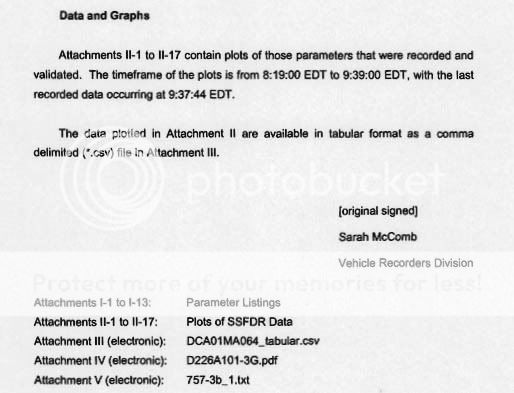
Specialist's Factual report, page 4:
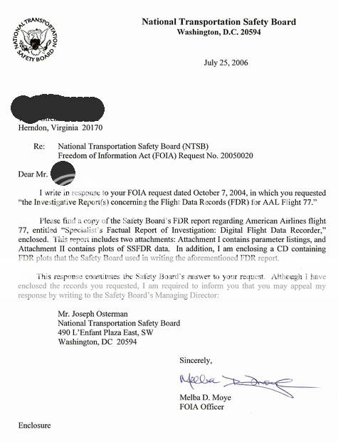
P49T FOIA letter to member "Undertow" accompanying their NTSB documents:
The first two attachments make up the bulk of the PDF itself - params and plots if you look at the headings. The CSV could be this same attachment III, but the title is different. The CSV from the pilots (AAL 77 tab) has no NTSB ID no attached
It could have no ID as it's an attachment to another doc, but why does an "electronic" file have a "printed" date? Probably nothing...
ETA: And you're right, no independently verifiable sources for their CSV. They're listed it as existing but not posted AS an attachment that I've seen.
[edit on 1-6-2007 by Caustic Logic]
Specialist's Factual report, page 4:
P49T FOIA letter to member "Undertow" accompanying their NTSB documents:
The first two attachments make up the bulk of the PDF itself - params and plots if you look at the headings. The CSV could be this same attachment III, but the title is different. The CSV from the pilots (AAL 77 tab) has no NTSB ID no attached
# American Airlines Flight 77 Pentagon
# 9/11/01 Boeing 757 N644AA
# Revision: January 28 2002 January 29 2002
# National Transportation Safety Board
# Date Printed: January 29 2002
# American Airlines Flight 77 Pentagon 9/11/01 Boeing 757 N644AA
# Revision: January 28 2002 January 29 2002 National Transportation Safety Board
# Date Printed: January 29 2002
It could have no ID as it's an attachment to another doc, but why does an "electronic" file have a "printed" date? Probably nothing...
ETA: And you're right, no independently verifiable sources for their CSV. They're listed it as existing but not posted AS an attachment that I've seen.
[edit on 1-6-2007 by Caustic Logic]
Originally posted by nick7261
Incredibly, or maybe a better description is un-F@!#ing-believably, I found a posting on Presidential candidate Dennis Kacunich's blog entitled, "Official Account of 9/11 Flight 77 Contradicted by Government's Own Data" in which Kacunich cites the PF911T and snowygrouch's account of the ahem... facts.
Whoa! What the heck political sucide is this? Who authorized this? First half-line is not too good:
Pilots for 9/11 Truth, an ad-hock international organization of pilots and aviation professionals,
It's here.
ETA: And what's up with Snowygrouch's 273 foot elevation? that's not what we're all seeing. How many different elevations can there be for this thing?
[edit on 1-6-2007 by Caustic Logic]
Originally posted by Caustic Logic
You are correct. It is about 30 feet. So if the FDR data of 173 feet must have been 1 second before he hit. He would have been at 93 feet in a descent. This seems to be at odds with those who saw him level clipping poles.
I took a look at the video and what struck me was that no pilot, even a highjacker is going to perform that maneuver to the right. There is no way the pilot can see anything during the turn (he is sitting in the left hand seat) yet he rolls out right on course. No way. None. If you were going to perform that maneuver you would do it to the left so that you can keep the Pentagon in sight all the time.
This whole thing doesn't make any sense. Why would a pilot start a RIGHT turn. He can't see anything out of the right side of the airplane?
And how did he roll out right on the correct heading and not have to make any adjustments back to the left?
And hit the Pentagon at 463 knots right a ground level? No. Not unlikely. Flat out impossible.
The elevation for that highway is ~40 feet above sea level according to the US Geological Survey.
There's a slightly recessed lagoon just out back at Potomac level, so it can't be too many tens of feet above MSL.
You are correct. It is about 30 feet. So if the FDR data of 173 feet must have been 1 second before he hit. He would have been at 93 feet in a descent. This seems to be at odds with those who saw him level clipping poles.
Apparently it shows the uncorrected altitude at the end (rounded to 180 feet) and it flies in north of the Navy Annex and Citgo. It's amazing. We have no idea where it came from... supposedly the NTSB. If you get any urge to look into it, it's really pretty odd and we'd love to hear any insights.
I took a look at the video and what struck me was that no pilot, even a highjacker is going to perform that maneuver to the right. There is no way the pilot can see anything during the turn (he is sitting in the left hand seat) yet he rolls out right on course. No way. None. If you were going to perform that maneuver you would do it to the left so that you can keep the Pentagon in sight all the time.
This whole thing doesn't make any sense. Why would a pilot start a RIGHT turn. He can't see anything out of the right side of the airplane?
And how did he roll out right on the correct heading and not have to make any adjustments back to the left?
And hit the Pentagon at 463 knots right a ground level? No. Not unlikely. Flat out impossible.
I've only read the first few posts, and the last posts on this page, so forgive me if I miss something etc.. but there are a few important points
I'd like to raise:
* are you saying that the animation and the CSV file are both faked in some way?
* I find it strange that both radio altimeters are either failed or invalidated. WRT the operating airline - what is the procedure regarding dual rad alt failure? Is the aircraft grounded, or can it dispatch as normal with certain limitation (e.g. no autoland)?
* are the animation and CSV totally separate from each other, come from different sources, but only the CSV file is known to come from the NTSB or other government agency directly?
If the data from the Pentagon is faked (and presumably by the pro official story camp) why:
1) would the altitudes be faked?
2) would they overlook the barometric setting that puts it at 400ft, and thus an overfly, when corrected for local pressure?
Surely if an aircraft hit the Pentagon, there would be no need to fake the data?
CL seems pretty sure an aircraft did hit, and I must say his evidence is pretty compelling, but if the CSV file is supposed to support the official story, I find it odd that they would have to fake the data if an aircraft really hit.
I'm at a point now where if a government had to fake data because no aircraft crashed from which to get real data, that in fact no aircraft hit, which is why they have to fake it.
From their point of view, I see no point in faking what should be real data. The only conclusion I can draw is that it is their only option.
What really happened to Flight 77? Did a Flight 93 occur to it, and that it landed someplace safe?
Here is another spin: what if the real Flight 77 either never existed, or was cancelled, and a pseudo Flight 77 flew?
What if Flight 93 and Flight 77 were only positioning flights with no flight number at all, the real flights were canceled to free up the aircraft, and from there, the biggest illusion in history took place?
When David Copperfield made the Eiffle Tower disappear, it never actually disappeared at all. What if the positioning flights flew and landed somewhere else safely? Might it explain the discrepency in the flight logs whereby an aircraft left an airport that it wasn't recorded landing at, because in-between, it was positioned empty there?
I know that is a lot to take on board, but there are so many holes there has to be a more logical explanation.
[edit on 1-6-2007 by mirageofdeceit]
mirage, 2 flights landed in ohio that morning well after all flights had been grounded. they mention it in either loose change 2 or in plane sight but
i havent been able to verify this from any other source.
2 flights landed in ohio that morning well after all flights had been grounded.
I know there was DAL1989 and this mystery flight (actually, confirmed Flight 93 by UA at the time) that landed at Cleveland.
Two flights AFTER the grounding....... if one was Flight 77, I'm lost as to what the other would be.
It was reported that over both the WTC and the Pentagon, strange white aircraft were seen flying. Could these be the two aircraft to which you refer?
Here is a big-time CT : what if all flights were grounded to stop the press from flying in their helicopters over the "crash" sites with cameras and recording activity that they didn't want to be seen?
new topics
-
WF Killer Patents & Secret Science Vol. 1 | Free Energy & Anti-Gravity Cover-Ups
General Conspiracies: 1 hours ago -
Hurt my hip; should I go see a Doctor
General Chit Chat: 2 hours ago -
Israel attacking Iran again.
Middle East Issues: 3 hours ago -
Michigan school district cancels lesson on gender identity and pronouns after backlash
Education and Media: 3 hours ago -
When an Angel gets his or her wings
Religion, Faith, And Theology: 4 hours ago -
Comparing the theology of Paul and Hebrews
Religion, Faith, And Theology: 5 hours ago -
Pentagon acknowledges secret UFO project, the Kona Blue program | Vargas Reports
Aliens and UFOs: 6 hours ago -
Boston Dynamics say Farewell to Atlas
Science & Technology: 6 hours ago -
I hate dreaming
Rant: 7 hours ago -
Man sets himself on fire outside Donald Trump trial
Mainstream News: 9 hours ago
top topics
-
The Democrats Take Control the House - Look what happened while you were sleeping
US Political Madness: 9 hours ago, 18 flags -
In an Historic First, In N Out Burger Permanently Closes a Location
Mainstream News: 11 hours ago, 16 flags -
A man of the people
Medical Issues & Conspiracies: 17 hours ago, 11 flags -
Man sets himself on fire outside Donald Trump trial
Mainstream News: 9 hours ago, 9 flags -
Biden says little kids flip him the bird all the time.
Politicians & People: 9 hours ago, 9 flags -
Michigan school district cancels lesson on gender identity and pronouns after backlash
Education and Media: 3 hours ago, 6 flags -
Pentagon acknowledges secret UFO project, the Kona Blue program | Vargas Reports
Aliens and UFOs: 6 hours ago, 6 flags -
Israel attacking Iran again.
Middle East Issues: 3 hours ago, 5 flags -
WF Killer Patents & Secret Science Vol. 1 | Free Energy & Anti-Gravity Cover-Ups
General Conspiracies: 1 hours ago, 5 flags -
Boston Dynamics say Farewell to Atlas
Science & Technology: 6 hours ago, 4 flags
active topics
-
Israel attacking Iran again.
Middle East Issues • 25 • : charlest2 -
Michigan school district cancels lesson on gender identity and pronouns after backlash
Education and Media • 8 • : TheMichiganSwampBuck -
I Guess Cloud Seeding Works
Fragile Earth • 29 • : Justoneman -
Man sets himself on fire outside Donald Trump trial
Mainstream News • 40 • : Vermilion -
When an Angel gets his or her wings
Religion, Faith, And Theology • 5 • : randomuser2034 -
Anyone one else having Youtube problems
Computer Help • 11 • : charlyv -
The Democrats Take Control the House - Look what happened while you were sleeping
US Political Madness • 68 • : Mahogani -
Candidate TRUMP Now Has Crazy Judge JUAN MERCHAN After Him - The Stormy Daniels Hush-Money Case.
Political Conspiracies • 404 • : Zanti Misfit -
In an Historic First, In N Out Burger Permanently Closes a Location
Mainstream News • 10 • : Degradation33 -
SC Jack Smith is Using Subterfuge Tricks with Donald Trumps Upcoming Documents Trial.
Dissecting Disinformation • 100 • : WeMustCare