It looks like you're using an Ad Blocker.
Please white-list or disable AboveTopSecret.com in your ad-blocking tool.
Thank you.
Some features of ATS will be disabled while you continue to use an ad-blocker.

Pentagon "NTSB animation" is wrong!
page: 18share:
You guys really need to look at Farmers work on the animation (not the csv file). Link was provided a few times on multiple pages and even a copy and
past of his article including pictures was provided. Study it.
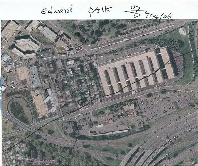
Nick, study the large picture at the top of this page i provided (also provided it on prior pages). Study that little compass in the lower left. That picture is the picture that was used for the cropped image in the Radar Alt thread. Nothing misleading. The only misleading argument made here is that you said numerous times in your post that the Pentagon was rotated in the P4T photo. Wrong. The more accurate statement would have been "I checked P4T website and it appears the screenshot taken of google earth where this photo is used for the crop, has North offset a bit to the left, this photo is not a north up picture". But if you had acually done the leg work, then you wouldnt have even needed to make the post.. right? (by the way.. zoom into the pentagon on google earth. You will see the default orientation just as it is in my large picture.. with North offset to the left. Of course that picture was taken with the older version of Google Earth, but it does the same thing with the new google earth.. i just tried it myself.
Finally, no one has the FDR. The only people who have the FDR are the FBI (reportedly). We have data claimed to be from AA77 FDR provided by the NTSB.
Originally posted by Caustic Logic
Well nick, you do try too hard sometimes, and I'm not sure I follow as to whether or not this graphic is misleading, but...
So the photo was rotated - not just the building but the whole photo, right?
The only way this is deceptive is if the Nav points pinned on were then placed AS IF up was north. If they are mapped in accurate to north on that map, then we just have a case of an accurate charting just turned a bit, for graphics reasons perhaps.
Is there informational miseladig going on here or just rotation?
Please clarify...
Just to clarify this whole subject of the rotated photo on the P49T site:
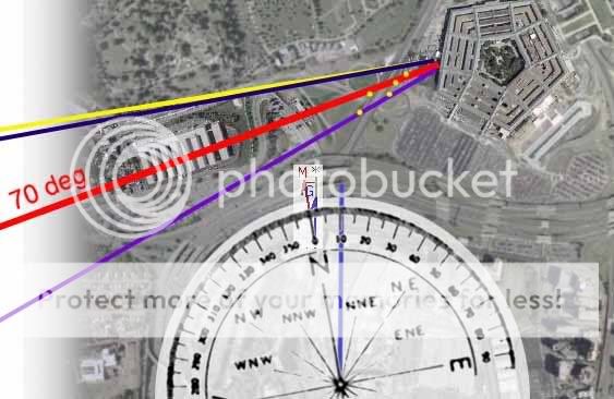
All I was doing was pointing out that the visual orientation of the Pentagon in the video is rotated about 10 degrees counter-clockwise from the 70 degree mag heading shown in the video, and that the P49T site also had a photo that shows the Pentagon with the same rotation counter-clockwise.
IF tha animation was created by somebody downstream of the NTSB, then maybe they used a photo like the one shown on the P49T site, already rotated counter-clockwise, to construct the graphics shown in the "NTSB" animation video. I just thought it was curious that the P49T site already had a photo on their site rotated to match the animation.
This could be nothing, or it could be a clue as to how the animation graphics were out of alignment with the 70 degree heading.
Originally posted by scrapple
IMO somebody sat in a top-line simulator and flew the take-off and attack run to produce the flight data. This file is then tweaked to ‘assist’ the magnetic compass heading to reflect the official story attack orientation.
This scenario makes no sense to me. If somebody is going to attempt to re-create the official flight path in a simulator, they would create it accurately. In fact, this type of thinking is exactly what makes the P49T version of events so difficult to believe.
What're you saying is that the government created a fake FDR file to reflect the official flight path, then leaked their screwed up data to snowygrouch, who gave it to Rob. The re-created FL 77 that the government screwed up then happened to match the eye-witnesses that Craig Ranke interviewed.
So in effect, in trying to fake the official FDR data the government mistakenly created FDR data that matched Ranke's witnesses.
The data and animation are packaged for consumption using this tweaked compass display; however (for reasons beyond me) they (the government) didn’t shift the terrain ‘clockwise through pentagon’ enough to match the true crash heading (as would have been seen by a real pilot out a real FT77 cockpit window).
How about re-thinking this same process from the point of view of somebody who might want to create an animation that showed FL 77 didn't hit the Pentagon.
They created the FL 77 flight path that went north of the Citgo and was too high to hit the Pentagon. They overlooked the fact that the 70 degree mag heading didn't match the visual terrain shown in the animation, and had to "reverse engineer" the rest of the story.
You're really missing the big picture. The animation CONTRADICTS the official story, so it makes no sense that it was created by the government to corroborate the official story. Second, the animation is internally wrong, i.e., faked.
Therefore, the animation was NOT the real flight path being leaked by somebody in the NTSB to tip off people about what really happened, because the animation can't be what really happened. Nor is it a constructed flight path to represent the official story.
That leaves one thing: the animation is a botched attempt to create evidence that FL 77 didn't approach the Pentagon along the official flight path, and that FL 77 didn't hit the Pentagon.
Now maybe this is disinfo put out by the NTSB/FBI/CIA to further discredit the truth movement, or maybe it's overzealous CTers conconcting evidence. Who knows?
Originally posted by johndoex
You guys really need to look at Farmers work on the animation (not the csv file). Link was provided a few times on multiple pages and even a copy and past of his article including pictures was provided. Study it.
Thanks for the link to Farmer's site. I've been reading it slowly trying to digest what he's saying. So far it's not been too convincing, especially the part about the 20 degree heading correction being spread equally throughout the entire data set. I'm not going to rush to judgement on it. I want to really make sure I understand what he's trying to get across.
Nick, study the large picture at the top of this page i provided (also provided it on prior pages). Study that little compass in the lower left. That picture is the picture that was used for the cropped image in the Radar Alt thread. Nothing misleading.
I understand what the picture represents. The photo is rotated counter-clockwise from the normal orientation which shows north-south straight up and down. The smaller photo does not include the compass.
My point was that this orientation of the photo pretty much matches the orientation of the physical representations shown in the "NTSB" animation video. Maybe whoever created the video used a similar photo which was rotated to create the visual representations that are shown in the animation video. I.e., maybe the map used for the animation was offset counter-clockwise as well. It almost looks like the map was rotated to reflect a magnetic north orientation.
The only misleading argument made here is that you said numerous times in your post that the Pentagon was rotated in the P4T photo. Wrong. The more accurate statement would have been "I checked P4T website and it appears the screenshot taken of google earth where this photo is used for the crop, has North offset a bit to the left, this photo is not a north up picture".
Correct. Your description is more accurate than saying the photo was rotated.
(by the way.. zoom into the pentagon on google earth. You will see the default orientation just as it is in my large picture.. with North offset to the left. Of course that picture was taken with the older version of Google Earth, but it does the same thing with the new google earth.. i just tried it myself.
Maybe we're getting close to figuring out why the objects shown in the animation video are out of alignment with the magnetic heading of the plane. What if the software used to create the animation assumed that the map files showed north as straight up, but for some reason the satellite photos used of the Pentagon area are rotated to the left? This would clear up the entire mystery of the heading problem with the animation video.
Finally, no one has the FDR. The only people who have the FDR are the FBI (reportedly). We have data claimed to be from AA77 FDR provided by the NTSB.
Do you have the original CDs that snowygrouch received or did he send you copies?
Originally posted by Caustic Logic
Maybe it was just an errored NTSB map rotation after all.
If so they've sure gotten us to waste a lot of time.
Herein lies the paradox of seeking the truth.
If the CTers are correct that 9/11 was a government plot, even a "let it happen" plot, you can be sure that part of the plot is a sophisticated post 9/11 psyops to discredit the CTers. There's no way in the world they could pull off something as substantial as 9/11 and not plan for the post 9/11 psyops. Part of the psyops is going to be misdirection and disinfo to discredit anybody who gets close to the truth, plus a lot of false leads that not only go nowhere, but backfire on CTers making wild claims.
But if the official story is correct, then the entirety of the CT "movement" has been nothing but a huge waste of time too.
Originally posted by nick7261
This could be nothing, or it could be a clue as to how the animation graphics were out of alignment with the 70 degree heading.
Got it. Interesting point. Is the rotation 20 deg? Never mind, I'll check that myself in a bit.
Originally posted by nick7261
Originally posted by Caustic Logic
Maybe it was just an errored NTSB map rotation after all.
If so they've sure gotten us to waste a lot of time.
Herein lies the paradox of seeking the truth.
If the CTers are correct that 9/11 was a government plot, even a "let it happen" plot, you can be sure that part of the plot is a sophisticated post 9/11 psyops to discredit the CTers. There's no way in the world they could pull off something as substantial as 9/11 and not plan for the post 9/11 psyops. Part of the psyops is going to be misdirection and disinfo to discredit anybody who gets close to the truth, plus a lot of false leads that not only go nowhere, but backfire on CTers making wild claims.
Really? The implications are unsettling! uckily there are no wild claims going on here, just some oddities that show, for example, the the FDR data was altered to conform to the official apologist whatever flight path.
But if the official story is correct, then the entirety of the CT "movement" has been nothing but a huge waste of time too.
Not a chance - a realistic chance - that the gov story is all or majorly true. But the further from reality the CTs get, the closer by comparison the OCT gets. People who admire reason and consensual reality will then migrate to the official story.
And the ravers at the edges slide further and farther out.
The gulf widens.
And with so much good, down home, all-American suspicion to begin with.
How convenient.
Originally posted by Caustic Logic
Not a chance - a realistic chance - that the gov story is all or majorly true.
You mean Sandy Berger really had a good reason to stuff papers down his pants and socks? And the Able Danger data wasn't ordered destroyed just to protect the terrorists' civil rights? And the 9/11 Commission wasn't loaded with D.C. insiders just because they were objective and the most qualified for the job??? Say it ain't so!
But the further from reality the CTs get, the closer by comparison the OCT gets. People who admire reason and consensual reality will then migrate to the official story.
Great observation. The disinfo is designed to make the CTers look even crazier than the 9/11 Commission, which makes people in the middle who already lean towards the official story get up and RUN to the official story, lest they be considered a complete nutcase. So if only Rosie O'Donnell would have been an OCTer we'd have a chance to sway public opinion...
Originally posted by nick7261
So in effect, in trying to fake the official FDR data the government mistakenly created FDR data that matched Ranke's witnesses.
THE ANIMATION/FDR DOES NOT MATCH THE WITNESSES!
[edit on 9-6-2007 by Craig Ranke CIT]
Originally posted by Craig Ranke CIT
THE ANIMATION/FDR DOES NOT MATCH THE WITNESSES!
[edit on 9-6-2007 by Craig Ranke CIT]
Craig, this is the flight path based on the witnesses, right?
The animation DOES generally match the witnesses in terms of the flight path NOT being south of the Citgo, and the altitude corresponding to a fly-over. The animation can't match all the witnesses because their accounts were all slightly different. The last segment of the flight path from the Naval Annex to the Pentagon generally matches, doesn't it?
Not quite - it comes in about straight, north of the annex all the way. (page one for vid ) It does not have this grand squiggle that, zoomed back,
almost looks like a smooth segue between two different paths.
But once it straightens out, yeah, a remarkably similarity.
Just another of the many coincidences of 9/11. Not usually much of a coincidence theorist but... trying... to maintain... unity.
[edit on 9-6-2007 by Caustic Logic]
But once it straightens out, yeah, a remarkably similarity.
Just another of the many coincidences of 9/11. Not usually much of a coincidence theorist but... trying... to maintain... unity.
[edit on 9-6-2007 by Caustic Logic]
Originally posted by Caustic Logic
It does not have this grand squiggle that, zoomed back, almost looks like a smooth segue between two different paths.
Too bad there wasn't some group of expert pilots who could comment on the grand squiggle that's reflected by the eye-witnesses. My instinct is that a plane traveling at 500 mph would have too much momentum to start the right bank at the Naval Annex and be able to straighten out in time to fly anywhere near the center of the Pentagon's west face.
But once it straightens out, yeah, a remarkably similarity.
This might be explained by the whole momentum thing I described in the above paragraph. It might be physically impossible to fly a plane at 500 mph and make the squiggle. This means that anybody attempting to create this flight path on a simulator for the purpose of making a video wouldn't be able to do it either. So what's left? Making a video animation that shows the two most important points - the plane flew north of the Citgo and too high to hit the Pentagon.
If it wasn't for that pesky 80 degree heading thing that the P49T... er... I mean that everybody else pointed out and made a big deal out of people might even have been fooled into thinking the animation was the *REAL* FL 77 flight path.
There is no possibility that the alleged Boeing 757 flew that yellow squiggle line for the simple fact that at 400 mph such a turn would have required
at least between a 75 degree and 90 degree angle of bank. If the staightening out of the squiggle started over the annex at 400 mph and there was only
2 more seconds of flight the pilot could not have even rolled into the bank much less completed the turn and rolled out to hit approxomately wings
level. I have already dsicussed roll rates of transport category aircraft and that they are limited electromechanically to prevent overstressing the
airframe so there is no possiblilty of a 'hot dog' pilot trying to do it anyway.
Originally posted by johnlear
There is no possibility that the alleged Boeing 757 flew that yellow squiggle line for the simple fact that at 400 mph such a turn would have required at least between a 75 degree and 90 degree angle of bank. If the staightening out of the squiggle started over the annex at 400 mph and there was only 2 more seconds of flight the pilot could not have even rolled into the bank much less completed the turn and rolled out to hit approxomately wings level. I have already dsicussed roll rates of transport category aircraft and that they are limited electromechanically to prevent overstressing the airframe so there is no possiblilty of a 'hot dog' pilot trying to do it anyway.
John,
Thanks for your commentary on this. Generally speaking, I'm guessing if this path were physically impossible then it would also be impossible to recreate with a flight simulator, right?
Also, do you know how the mapping in flight simulators work? Specifically, do you have any idea what area each map section might cover? The reason this may be important is because from what we've seen with the "NTSB" animation, it might be possible that the Pentagon area map section was loaded into the simulator with a skewed orientation. The most basic problem with the animation is that the visual orientation of the Pentagon doesn't match the orientation of the Dulles runway.
Originally posted by nick7261
If it were a multi million dollar simulator for the Boeing 757, yes, they would make it impossible to make that turn. But if it was a MS Flight Smulator or something like that, no, they are not going to have the bank angle and turn limitatins programmed in, so there will be no limitation to what the little airplane on the screen can do. Thats just game stuff.
I don't know from what database the maps were loaded. I don't understand the problem of the 'skewed orientation' of the Pentagon. Can you please explain that. (I have read all the posts and I still don't understand what the probelm is.)
[John,
Thanks for your commentary on this. Generally speaking, I'm guessing if this path were physically impossible then it would also be impossible to recreate with a flight simulator, right?
If it were a multi million dollar simulator for the Boeing 757, yes, they would make it impossible to make that turn. But if it was a MS Flight Smulator or something like that, no, they are not going to have the bank angle and turn limitatins programmed in, so there will be no limitation to what the little airplane on the screen can do. Thats just game stuff.
Also, do you know how the mapping in flight simulators work?
Specifically, do you have any idea what area each map section might cover? The reason this may be important is because from what we've seen with the "NTSB" animation, it might be possible that the Pentagon area map section was loaded into the simulator with a skewed orientation. The most basic problem with the animation is that the visual orientation of the Pentagon doesn't match the orientation of the Dulles runway.
I don't know from what database the maps were loaded. I don't understand the problem of the 'skewed orientation' of the Pentagon. Can you please explain that. (I have read all the posts and I still don't understand what the probelm is.)
Originally posted by johnlear
I don't know from what database the maps were loaded. I don't understand the problem of the 'skewed orientation' of the Pentagon. Can you please explain that. (I have read all the posts and I still don't understand what the probelm is.)
I know... it can be confusing.
Basically the problem with the "NTSB" animation is this:
The little plane on the screen is shown flying at different headings and different altitudes like you would expect. But what's also shown on the screen are objects on the ground in relation to the plane on the screen.
When the plane takes off from Dulles, the plane is at the same heading that runway 30 at Dulles is -300 degrees magnetic. Now the plane flies out to Kentucky, makes its turn, and heads back towards D.C.
When the plane on the screen makes it's final run at the Pentagon, the heading on the screen dial shows 70 degrees magnetic. So far so good.
Now here's the problem.
The images on the screen on the ground, the Naval Annex, the highways, and the Pentagon itself are oriented in relation to the plane in such a way that the little plane on the screen would have to be approaching at a magnetic heading of about 80-90 degrees, not 70 degrees.
In other words, the objects in the animation on the ground are lined up with the little plane in a way that's inconsistent with the real world alignment. I'm using the runway at Dulles as a reference point because it's on the ground too. The plane on the screen lines up with the runway properly, but doesn't line up with the Naval Annex and the Pentagon properly in relation to the magnetic heading shown on the screen.
The question becomes why?
The possible answers are:
1) The animation is based on the REAL FL 77 FDR data. The REAL flight path took FL 77 north of the citgo and Naval Annex, and the altitude was too high to hit the Pentagon. The implication is that the REAL FL 77 flew over the Pentagon. The NTSB tried to fake the animation by inserting the mag heading of 70 on the screen, but screwed up by leaving the actual visual flight path unaltered.
OR
2) Somebody else tried to fake the animation to make it look like the flight path was north of the Citgo and too high to hit the Pentagon. They weren't able to keep either the csv data file, the animation, or their explanations consistent. The plane on the animation looks like it's coming in north of the Citgo, but the 70 degree mag heading makes this a physical impossibility.
OR
3) Somehow the map of the Pentagon area in the database was just innocently and mistakenly loaded at the wrong orientation, with north on the map being more closely aligned with magnetic north, i.e., rotated about 10 or so degrees counter-clockwise from true north (forgive me if I'm not using the proper terminology).
In any case, the animation is WRONG for lack of a better word. A better description might be, "The animation alleged to have originated from the NTSB shows FL 77 approaching the Pentagon with an instrument reading of 70 degrees magnetic but with a visual approach closer to 80-90 degrees magnetic." These two statements are facts and not in dispute.
Another way to think of it: The plane on the screen is shown approaching the Pentagon with a heading that should correlate to an 80-90 readout on the dial face in the animation, but the dial face shows 70 instead.
Hope that helps!
Originally posted by nick7261
Yes, greatly. Thanks for the very thorough explanation.
Hope that helps!
Yes, greatly. Thanks for the very thorough explanation.
The images on the screen on the ground, the Naval Annex, the highways, and the Pentagon itself are oriented in relation to the plane in such a way that the little plane on the screen would have to be approaching at a magnetic heading of about 80-90 degrees, not 70 degrees.
I see!! Thanks for the explanation!
I see Nick is having problems with digesting what my analysis of the NTSB animation is saying. If with his engineering background he is having
problems, then I thought I should make a very simple outline of the major observations.
1. When the animation begins, the heading (with mag correction) matches the visual plane sitting on the runway at Dulles. Every thing good at this point.
2. As AA77 takes off, flight controllers give an initial heading to the pilot and the turn is made to that heading. Again, the instruments match the heading.
3. Within one minute of acquisition of the initial heading, the plane takes a small turn to the right (visually apparent by comparing alignment of ground track to grid). There is no air traffic controller instruction to make the turn and the heading instrumentation does not change, other than to fluctuate +/- one degree.
4. Through the remaining animation path, there are points when comparison of the ground track relative to the grid is possible. During these intervals, there is a significant (10+ degrees) delta between the two. Keep in mind they were perfectly matched at take-off and when the initial heading was obtained.
5. After the final 330 degree turn maneuver, there is (as we have been discussing) a 20 degree delta between the take-off heading (matches Dulles runway) and the final approach heading (official approach path) indicated by the ground track compared to the grid.
I have put in an FOIA with the NTSB requesting the parameters used to generate the animation, but to date there has been no response. Some have said that the animation is generated using the physics data in the FDR. If that is the case, then that would account for the deviation observed if the heading data had indeed been tampered with. That does not mean that is the case, but certainly is a possibility. That is why it is important to understand how the animation was generated. I will leave that to others since it really is in the domain of professional pilots and aeronautical engineers (outside my expertise).
The csv simply by the beginning and ending coordinates (latitude and longitude) being erroneous indicates a problem. My analysis simply compared physics data with instrument data to see if they matched. There were areas they did not, and in the case of the longitude data, significant deviations were noted. Based on my own experience with data fitting, my observations were consistent with an error being distributed across that data segment (fitted data). That does not preclude another factor being the cause, and for my purposes is irrelevant.
As I explained to Rob early on, I can be dogmatic about one thing and one thing only. Some of the data has been “fitted” or “smoothed”. Whether that is intentional or from some other unknown mechanism is simply beyond the available information to determine. I hope this helps as well.
Originally posted by spcengineer
I see Nick is having problems with digesting what my analysis of the NTSB animation is saying. If with his engineering background he is having problems, then I thought I should make a very simple outline of the major observations.
As I explained to Rob early on, I can be dogmatic about one thing and one thing only. Some of the data has been “fitted” or “smoothed”. Whether that is intentional or from some other unknown mechanism is simply beyond the available information to determine. I hope this helps as well.
Thanks for the summary of your findings. I'm a little busy with the my kids tonight, so I won't have much time to look at this over the weekend.
I have already looked at your explanations on your site, and the question that came to my mind was this:
What benchmark are you using to make the conclusion that the data was fitted? From what I read, it seemed like you simply presumed the data should look a certain way in terms of uniformity, and when it didn't look like you expected, you concluded it was fitted. I'm not sure this is a valid methodology.
For example, in the stock market, some charts have almost constant slopes over a 2-5 year period. But obviously this is real data, not fitted. Isn't this the same type of methodology you used to conclude the FDR data was fitted?
Originally posted by spcengineer
Could you post an example please. (Is it possible that this error is due to winds aloft?)
I missed this. How do we know the lat/long is erroneous at the ending?
What are you calling 'physics data' and what are you calling 'instrument data?
I'm confused here. Are you saying that only longitude was in error? Or exactly what do you mean 'longitude data, significant deviations were noted'?
Thanks and sorry if I am a little behind the power curve on something you may have already explained.
4. Through the remaining animation path, there are points when comparison of the ground track relative to the grid is possible.
Could you post an example please. (Is it possible that this error is due to winds aloft?)
The csv simply by the beginning and ending coordinates (latitude and longitude) being erroneous indicates a problem.
I missed this. How do we know the lat/long is erroneous at the ending?
My analysis simply compared physics data with instrument data to see if they matched.
What are you calling 'physics data' and what are you calling 'instrument data?
There were areas they did not, and in the case of the longitude data, significant deviations were noted.
I'm confused here. Are you saying that only longitude was in error? Or exactly what do you mean 'longitude data, significant deviations were noted'?
Thanks and sorry if I am a little behind the power curve on something you may have already explained.
new topics
-
God's Righteousness is Greater than Our Wrath
Religion, Faith, And Theology: 3 hours ago -
Electrical tricks for saving money
Education and Media: 7 hours ago -
VP's Secret Service agent brawls with other agents at Andrews
Mainstream News: 8 hours ago -
Sunak spinning the sickness figures
Other Current Events: 9 hours ago -
Nearly 70% Of Americans Want Talks To End War In Ukraine
Political Issues: 9 hours ago -
Late Night with the Devil - a really good unusual modern horror film.
Movies: 11 hours ago
top topics
-
VP's Secret Service agent brawls with other agents at Andrews
Mainstream News: 8 hours ago, 9 flags -
Cats Used as Live Bait to Train Ferocious Pitbulls in Illegal NYC Dogfighting
Social Issues and Civil Unrest: 12 hours ago, 8 flags -
Electrical tricks for saving money
Education and Media: 7 hours ago, 4 flags -
HORRIBLE !! Russian Soldier Drinking Own Urine To Survive In Battle
World War Three: 16 hours ago, 3 flags -
Nearly 70% Of Americans Want Talks To End War In Ukraine
Political Issues: 9 hours ago, 3 flags -
Sunak spinning the sickness figures
Other Current Events: 9 hours ago, 3 flags -
Late Night with the Devil - a really good unusual modern horror film.
Movies: 11 hours ago, 2 flags -
The Good News According to Jesus - Episode 1
Religion, Faith, And Theology: 14 hours ago, 1 flags -
God's Righteousness is Greater than Our Wrath
Religion, Faith, And Theology: 3 hours ago, 0 flags
active topics
-
Sunak spinning the sickness figures
Other Current Events • 6 • : angelchemuel -
HORRIBLE !! Russian Soldier Drinking Own Urine To Survive In Battle
World War Three • 33 • : Degradation33 -
How ageing is" immune deficiency"
Medical Issues & Conspiracies • 34 • : angelchemuel -
Nearly 70% Of Americans Want Talks To End War In Ukraine
Political Issues • 13 • : Freeborn -
Mood Music Part VI
Music • 3101 • : ThatSmellsStrange -
VP's Secret Service agent brawls with other agents at Andrews
Mainstream News • 41 • : ThatSmellsStrange -
New whistleblower Jason Sands speaks on Twitter Spaces last night.
Aliens and UFOs • 55 • : baablacksheep1 -
Cats Used as Live Bait to Train Ferocious Pitbulls in Illegal NYC Dogfighting
Social Issues and Civil Unrest • 20 • : Asher47 -
Electrical tricks for saving money
Education and Media • 4 • : Lumenari -
DONALD J. TRUMP - 2024 Candidate for President - His Communications to Americans and the World.
2024 Elections • 514 • : WeMustCare