It looks like you're using an Ad Blocker.
Please white-list or disable AboveTopSecret.com in your ad-blocking tool.
Thank you.
Some features of ATS will be disabled while you continue to use an ad-blocker.

Pentagon "NTSB animation" is wrong!
page: 16share:
No prob. I know you're a busy man more or less, and I have time to find out. No rush.
Snowygrouch, yeah, I know, I should drop him a line...
I just have a habit of kind of doing things out in the open. I understand there's other avenues as well... more discrete.
Yeah, i can go there too, I'm just not ready.
ETA: I make it sound like I think he's hitting on me.
Nevermind, half drunk.
[edit on 8-6-2007 by Caustic Logic]
Originally posted by johndoex
Ok.. im gonna throw Nick some hints [...]
And let me help
Hint - Check dates of Farmers blog, Snowygrouch's cover letter, Mick Harrison's cover letter which specifically notes 'animation', and JREFer SLOB's google video upload date which was uploaded a few days after receipt.
I don't even have to look that one up. One animation only when Farmer wrote that line. Nothing in that one. Sorry Nick.
Hint - There is an unedited csv file, an unedited .fdr file and an edited .csv file which was decoded from the .fdr file.
Thanks, that helps towards my questions. I don't think you're a high priest, Rob, but you're not an answering ... spewing ... device ... either. Legwork... gettin' to it.
We have never created any animation of the flight path from any csv file from AA77 information provided by the NTSB.
Agreed, nick reads too much into two instances of "decoding" on that point. It probably meant more like into a visual graph or something. Interestingly, the NTSB does mention a CSV file that was plotted out as attachment II in their PDF version. It's supposed to be a readable graph of about what they were looking for, presumably the same exact data that formed your L3, CSV, etc.
So a fully graphed interprettion of the data is available for download here: (77 FDR study) It looks like this - alt, bearing, airspeed etc.
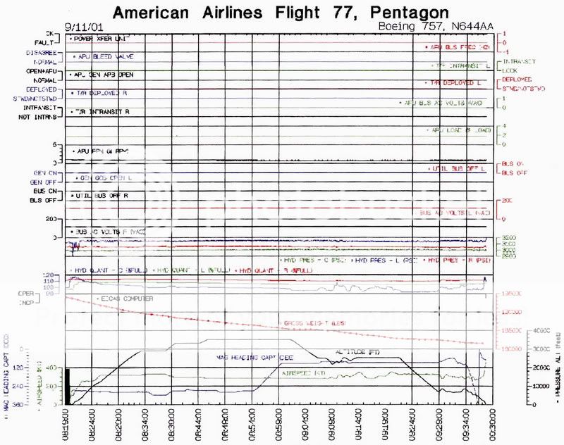
I'm not sure the pilots' take on this document, if it's altered, etc. There aare some links they provide, etc. It's probably got it's problems in conflicting with parts of the data UT got. It is undeniably a giant data set. My csv is still only txt, so I see it every time I open the sucker.
You are thoroughly confused.. nothing personal.. but you're getting there...
He's right Nick. If you want to get somewhere, get some better traction. Dig in! You even have a readable CSV unlike me.
[edit on 8-6-2007 by Caustic Logic]
Clarification on "only one animation". That was my understanding of the release timeline from P4T. They would be the authority on that subject, not
me. At that point I was on a learning curve myself.
Also of note, the csv has greater than 256 data fields. Excel will open it, but is limited to 256 columns per sheet. If anyone has problems getting all of the data fields imported, then contact me via email.
Most likely I will not be visiting this forum again in the near future (I try to stay away from forums). Any questions on my work, then drop me an email ([email protected]) or phone call (901-291-3237).
Have fun data mining
Originally posted by spcengineer
Also of note, the csv has greater than 256 data fields. Excel will open it, but is limited to 256 columns per sheet. If anyone has problems getting all of the data fields imported, then contact me via email.
Thanks much! You might want to consider editing those back out while you can, but I got 'em anyway. I have had problems with the file...
Most likely I will not be visiting this forum again in the near future (I try to stay away from forums).
Thank you for contributing, sir. Sorry I'm not more familiar with your works yet, but some good stuff I have bookmarked anyways.
Originally posted by nick7261
Also, I'm curious why John Farmer would post this comment on his blog:
"Also, the animation was not sent to all of the FOIA requestors, but to only one individual. This leads me to believe that it was an inadvertent disclosure (or something else I won’t discuss at this time).
911files.info...
Is it really true that the animation was only sent to 1 FOIA requester, and that was snowygrouch? Do you have any idea what the "something else" is that Farmer doesn't want to discuss?
More to the point - how does he know that it was only sent to one requestor? Does he have a position such that he can see ALL FOIA requests going into the NTSB, AND know how they were dealt with?
Oh... and just a reminder, you avoided my question about whether or not you actually have software to decode a csv file and turn it into an animation of the flight path. Do you? If so, what software are you using?
Good question!
[edit on 8-6-2007 by mirageofdeceit]
I've just had a closer look at the CSV file I have here. There is some data that I can extract but it will take some time. I'm picking out the
altitudes (both of them) the DME distance, DME frequencies in use and it appears the course pointer is recorded also giving a bearing to the station.
DMEs rarely move, so as long as they are still there, we have some data to use for triangulation of the aircrafts position.
What is the chance of a forger thinking of altering that data?
[edit on 8-6-2007 by mirageofdeceit]
What is the chance of a forger thinking of altering that data?
[edit on 8-6-2007 by mirageofdeceit]
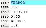
How convenient is this???? The DME frequencies are "#ERROR". Hmm. Why is that? Note that I have been unable to find any DME within 3.2 nm of the
aircraft. 1.5 nm ties in with DCA. Even a secret DME at the Whitehouse is out as that is 5.2 nm away. According to another CSV file I've seen, these
frequencies were auto-tuned.

Now I've identified some data, I should be able to more easily identify this data in the whole file. I'm looking at writing a piece of software that reads it for you, and so you can choose which parameters to view.
[edit on 8-6-2007 by mirageofdeceit]
TRACK ANGLE (TRUE): 61.2
TRACK ANGLE (MAGNETIC): 71.4
Now I've identified some data, I should be able to more easily identify this data in the whole file. I'm looking at writing a piece of software that reads it for you, and so you can choose which parameters to view.
[edit on 8-6-2007 by mirageofdeceit]
Originally posted by johndoex
You can call us liars, bogus etc because we refuse to spoon feed you.
I never called you liars. I said your reasoning was seriously flawed, and your presentation is misleading. It's the misleading part of your presentation that causes confusion.
After you create the confusion with your disjointed misleading postings, you expect the public to go on a treasure hunt and research all of the stories about SnowyGrouch, UnderTow, and SLOB and expect people to simply take everybody's word that they're telling the truth? Do you seriously expect that people are going to just accept your premise that two guys you know were "slipped" data files from the NTSB that nobody else received? And that the data files which were "slipped" to two of your associates were tampered with, but coincidentally matched the witnesses your other associate interviewed?
And you seem surprised that people question this?
And it is "bogus" to that you used and animation file and a csv file that you claim is bad data to insinuate that it represents FL 77's actual flight path. In fact, this is *YOUR* exact quote when describing the "NTSB" animation video that you KNOW has been tampered with:
"This is the final maneuver performed by the aircraft which hit the Pentagon on September 11, 2001. This animation was provided by the NTSB and is accurate in terms of the flight data recorder on board this aircraft. It has not been altered by anyone after it was received from the NTSB."
1. You knew the animation was altered so it was wrong to state as fact that this was the final maneuver performed by the aircraft that hit the Pentagon.
2. You knew the animation didn't match the csv file and therefore was NOT accurate in terms of the flight data recorder on board the aircraft.
3. You had no way to know if snowygrouch or undertow gave you files that were different than the files they received from the NTSB.
This is also from YOU:
"Our brother site that has released their Pentagon Eyewitness documentary interviewing 4 eyewitnesses on location including two Pentagon Police Officers all confirming the flight path North of the Citgo Gas station as seen in Pandora's Black Box - Chapter Two."
So now here's where you're totally misleading. You're claiming that the PentaCon, your "brother" organization, has 4 witnesses that have confirmed the animation that you KNOW does NOT represent the actual Flight 77 approach path. I.e., the animation is WRONG like CL said to start this thread, so why do you care that the PentaCon witnesses have confirmed a WRONG animation?
Even if your story is true, don't you grasp yet how ridiculous your story *appears*? Here's your story:
Somebody at the NTSB "slipped" two of your associates, and nobody else, doctored csv and animation files, plus the raw .fdr file, which don't match each other, and which coincidentally just happen to match the 4 eye witnesses your "brother" organization interviewed.
It's truly an amazing coincidence that the NTSB "slipped" you a doctored animation and a doctored csv file, and "slipped" you the "raw" .fdr file, that none of the data files matched each other, but that they ALL matched the PentaCon witnesses.
Why would you expect the public to buy this story with the sparse documentation that you have to substantiate it?
Originally posted by mirageofdeceit
DME means Distance Measuring Equipment. Where did you find the statement that "DME's are relative to MAGNETIC north'. Thanks.
NOTE: DMEs are relative to MAGNETIC north.
DME means Distance Measuring Equipment. Where did you find the statement that "DME's are relative to MAGNETIC north'. Thanks.
Uh - yeah. I was thinking of VOR/DME when I wrote that. Thanks.
It also has a data field:
I take gps to mean Global Positioning System.
[edit on 8-6-2007 by mirageofdeceit]
[edit on 8-6-2007 by mirageofdeceit]
It also has a data field:
NAVgps = 1
I take gps to mean Global Positioning System.
[edit on 8-6-2007 by mirageofdeceit]
[edit on 8-6-2007 by mirageofdeceit]
Originally posted by spcengineer
Most likely I will not be visiting this forum again in the near future (I try to stay away from forums). Any questions on my work, then drop me an email ([email protected]) or phone call (901-291-3237).
Have fun data mining
John,
Are you the John Farmer that appeared in Pandora's Black Box testifying at the 9/11 Commission hearings? Or is it just a coincidence that a John Farmer was a member of the 9/11 Commission staff?
Originally posted by mirageofdeceit
Thats correct. NAVgps=1 means that the difference between the VOR/DME position and GPS position is 1 mile.
It also has a data field:
NAVgps = 1
I take gps to mean Global Positioning System.
Thats correct. NAVgps=1 means that the difference between the VOR/DME position and GPS position is 1 mile.
..not that NAVgps is either equipped or functioning? I only see one entry for that. Which DME would it be comparing to?
Originally posted by nick7261 If the animation software is reading a csv file to create the animation, it doesn't make sense that the graphics wouldn't line up with the edited csv data....
........So this means that something is drastically wrong with the animation video.
Obviously.
How can a still frame from one simulation animate two conflicting parametrics at the same time - (70*Mag diplayed on the virtual compass AND a cockpit view (true heading) showing 80-90*? )
NTSB to make a perfect forgery would want to 'rotate the map' clockwise ~10* throught the center of the Pentagon (figuratively) to match their story of the strike run......and do so slowly over the course of the flight's simulation so that they are not initially shown taking off in a farmer's field at Dulles.
Or maybe the animation is correct and the data is fixed! Animation is released on a separate disk - executable file - from the data files right? No one has yet admitted to 'making' an animation other than NTSB's. All released animations have corroborated so far - per this discussion.
So do you still imply that P4911T or other like persons/groups created the displayed schism in the animation? Did they do this knowing that CIT would add their North of CITGO witnesses to corroborate their 'map rotation' so obviously contrary to the navigational realities of 70mag displayed?
Forget about edited file data for the moment, and reason through the animated still screen disparity.
[edit on 8-6-2007 by scrapple]
Originally posted by mirageofdeceit
no
The comparison is to where ever the combination of VOR/DME's (NAV) think they are to where the GPS thinks it is. The difference between the 2 is only one mile so the pilot can be pretty sure he is where he thinks he is. There is a hierarchy in the system with the question being, "Who do I believe the Most?" between VOR/DME, DME/DME, GPS, INS, IRS. Not all airplanes have all those and I didn't fly the 757 so I don't know how the hierarchy works. But the bottom line is if the comparitive difference between anything and anything is 1 mile then you are probably there.
..not that NAVgps is either equipped or functioning?
no
I only see one entry for that. Which DME would it be comparing to?
The comparison is to where ever the combination of VOR/DME's (NAV) think they are to where the GPS thinks it is. The difference between the 2 is only one mile so the pilot can be pretty sure he is where he thinks he is. There is a hierarchy in the system with the question being, "Who do I believe the Most?" between VOR/DME, DME/DME, GPS, INS, IRS. Not all airplanes have all those and I didn't fly the 757 so I don't know how the hierarchy works. But the bottom line is if the comparitive difference between anything and anything is 1 mile then you are probably there.
Originally posted by scrapple
How can a still frame from one simulation animate two conflicting parametrics at the same time - (70*Mag diplayed on the virtual compass AND a cockpit view (true heading) showing 80-90*? )
There is a major problem with the animation graphics. Namely, the animation graphics show that the Pentagon is not aligned with the Dulles runway like it is in real life. I.e., the animation graphics don't reflect the real world in terms of the magnetic heading shown in the video.
NTSB to make a perfect forgery would want to 'rotate the map' clockwise ~10* throught the center of the Pentagon (figuratively) to match their story of the strike run......and do so slowly over the course of the flight's simulation so that they are not initially shown taking off in a farmer's field at Dulles.
No, this does't make sense either because the graphics for the runway and Pentagon are internally inconsistent within the animation, while the actual heading reading matches the official story.
In fact, it seems to me more likely just the opposite of what you said. It looks more like somebody wanted to show the flight path coming in VISUALLY north of the Citgo so the map was rotated counter-clockwise on the approach to the Pentagon. I'm theorizing that the flight simulator software would have maps loaded for differenct sections at a time. Maybe there is a way to adjust the rotation of each map that's loaded into a simulator.
In any event, it looks like the heading numbers in the animation are consistent, but that the map graphics are incorrect.
Or maybe the animation is correct and the data is fixed!
No, this can't be because of what I just explained about the relative positions of the runway and the Pentagon. The only way the animation can represent what it does is for the graphics to have been rotated 10+ degrees counter-clockwise between the Dulles runway and the Pentagon approach.
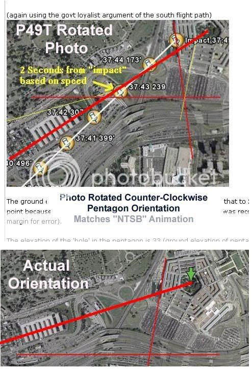
Interestingly, the ONLY other place I've seen an image of the Pentagon rotated 10+ degrees counter-clockwise is on the P49T website. Check this out. This is an image from the Pilots for 9/11 Truth website that has the Pentagon ROTATED COUNTER-CLOCKWISE 10+ DEGREES. Is this a coincidence?
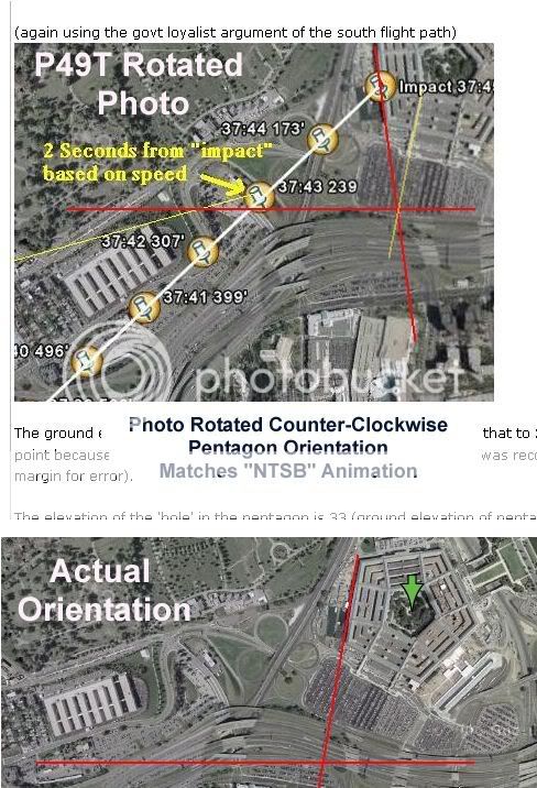
z9.invisionfree.com...
What makes this graphic interesting is that it's used in a discussion about altitude, not heading. For some reason Rob decided to use an overhead photo of the Pentagon that's been rotated counter-clockwise to almost match exactly the orientation of the Pentagon shown at the end of the "NTSB" animation video. This photo has been rotated and cropped to create the appearance that the Pentagon is oriented the same as the animation video. Why would Rob have a photo of the Pentagon on his site that's been rotated counter-clockwise 10+ degrees to match almost exactly the orientation of the Pentagon shown in the "NTSB" animation video???
Here's a direct link to his post on P49T:
z9.invisionfree.com...
So do you still imply that P4911T or other like persons/groups created the displayed schism in the animation? Did they do this knowing that CIT would add their North of CITGO witnesses to corroborate their 'map rotation' so obviously contrary to the navigational realities of 70mag displayed?
Forget about edited file data for the moment, and reason through the animated still screen disparity.
I never implied that P49T DID fake the animation. I just pointed out the possibility that the data was faked and unable to be authenticated. It also really seemed ludicrous that P49T would repeatedly refer to an obviously faked animation in a way that implied it represented the *real* flight path, and that this *real* flight path just coincidentally matched the PentaCon witnesses, more or less.
Rob has shown me nothing to make me believe that he actually can authenticate that the animation came from the NTSB. He is now referencing a poster on the JREF forum named SLOB that supposedly put up his own animation file that matches P49T's animation file. SLOB registered on JREF in Oct. 2006, about 1 month after P49T.org was registered, and about 1 month before pentacon.com was registered. The link to download SLOB's animation only shows that the animation has been downloaded 1 time. I tried downloading it and it didn't work.
So to answer your question, there are two scenarios to choose from:
1) Somebody in the NTSB secretly "slipped" a WRONG animation file to snowygrouch, who then graciously turned over this file to Rob. As luck would have it, Rob already had a csv file that was "slipped" to UnderTow. Somehow they would also acquire a "slipped" raw .fdr file from the NTSB.
None of these "slipped" files would match each other, and all would show signs of being manipulated or tampered with. However, each of these files that Rob claims originated with the NTSB, although not matching with each other, would corroborate Craig Ranke's PentaCon witnesses. Rob and Craig would then start "brother" organizations, promoting each other's films that tackle different parts of the government cover-up of what really happened to Flight 77.
Rather than go to the authorities with this "smoking gun" evidence of a government cover-up, Rob decided to start a web site and produce a series of videos called Pandora's Black Box and market them to the CT community.
OR...
2) Rob wasn't happy that he was removed from being a moderator at the Loose Change Forum, and set out to make a name for himself in the world of 9/11 CT gurus. Somebody dreamed up a plan to create an animation video that would show FL 77 coming in along the north-of-Citgo path, AND too high, just like Ranke's witnesses were going to say happened.
Somehow, between Rob, UnderTow, and snowygrouch, they created a variety of files that were allegedly from the NTSB, but that could never be authenticated as coming from the NTSB. The files didn't match each other and were declared "fake" by their own cited "math expert." But that didn't stop Rob and P49T from continuing to use the animation to promote PBB as showing the *real* flight path of FL 77.
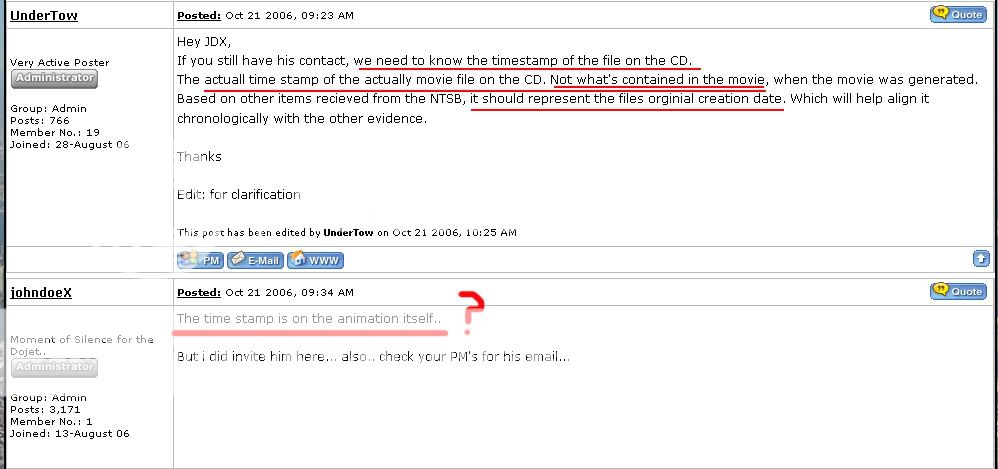
Rob then became angry at anybody who disagreed with him and challenged the authenticity of what he was claiming, and began banning people from his P49T forum who questioned him. He even ignored UnderTow's request to get some sort of time stamp off the data file from the NTSB animation CD, claiming that the time stamp was contained in the animation itself.
I don't have all the facts to pass judgement on Rob. Maybe his story is true, maybe it isn't. But what I've outlined above are basically the two possible realities to choose from. Look at the facts yourself and make your own conclusions.
Originally posted by nick7261 because the graphics for the runway ........are internally inconsistent within the animation.
Is the animated (cockpit view) graphic depiction of a Dulles runway takeoff out of sync:
1)with the magnetic compass display prior to take-off?
2)with FDR data at take-off driving both the above virtual compass or the 3D window view?
Picture posted by Nicky (you're nicky again Nicky)
I did a quick paint line extending from center of pentagon through the Annex. The whole bottom picture itself is rotated. Try lining them both up in the same orientation first my friend.
The pentagon is not rotated in our picture. It is a direct screenshot off google earth.. i did it myself. Anyone who knows how to superimpose the pictures on google earth will be able to see that both pictures above match google earth and neither pentagon is 'rotated' (unless perhaps Google Earth rotated it themselves)
(this guy is an engineer? or is he intentionally trying to cause confusion...)
Didnt have time to read any other replies..
typos
ETA: And that first picture where i drew the flight path was via the csv file heading BEFORE we even got the animation.
[edit on 8-6-2007 by johndoex]
[edit on 8-6-2007 by johndoex]
Originally posted by nick7261 It looks more like somebody wanted to show the flight path coming in VISUALLY north of the Citgo so the map was rotated counter-clockwise on the approach to the Pentagon.
So to be clearer on your position-
-you are insinuating that someone has tampered with the animated terrain referent of the simualtion.
-About this disparity - (of which it seems you are ok with the displayed 70* mag/60*actual - i.e. offical story) you are really more troubled by the 3D visual reference which backs North of Citgo and conspiracy.
And while I dont want to put words on your screen, If I am hearing you right it is also your opinion that this tampering was probably not done by NTSB or other official story body.
scrap
[edit on 8-6-2007 by scrapple]
Originally posted by nick7261
John,
Are you the John Farmer that appeared in Pandora's Black Box testifying at the 9/11 Commission hearings? Or is it just a coincidence that a John Farmer was a member of the 9/11 Commission staff?
"I was shocked at how different the truth was from the way it was described," John Farmer, a former New Jersey attorney general who led the staff inquiry into events on September 11, said in an August 2006 interview
en.wikipedia.org...
45 seconds. It is a common enough name.
new topics
-
Maestro Benedetto
Literature: 8 minutes ago -
Is AI Better Than the Hollywood Elite?
Movies: 17 minutes ago -
Las Vegas UFO Spotting Teen Traumatized by Demon Creature in Backyard
Aliens and UFOs: 3 hours ago -
2024 Pigeon Forge Rod Run - On the Strip (Video made for you)
Automotive Discussion: 4 hours ago -
Gaza Terrorists Attack US Humanitarian Pier During Construction
Middle East Issues: 5 hours ago -
The functionality of boldening and italics is clunky and no post char limit warning?
ATS Freshman's Forum: 6 hours ago -
Meadows, Giuliani Among 11 Indicted in Arizona in Latest 2020 Election Subversion Case
Mainstream News: 6 hours ago -
Massachusetts Drag Queen Leads Young Kids in Free Palestine Chant
Social Issues and Civil Unrest: 6 hours ago -
Weinstein's conviction overturned
Mainstream News: 8 hours ago -
Supreme Court Oral Arguments 4.25.2024 - Are PRESIDENTS IMMUNE From Later Being Prosecuted.
Above Politics: 9 hours ago
top topics
-
Krystalnacht on today's most elite Universities?
Social Issues and Civil Unrest: 9 hours ago, 9 flags -
Supreme Court Oral Arguments 4.25.2024 - Are PRESIDENTS IMMUNE From Later Being Prosecuted.
Above Politics: 9 hours ago, 8 flags -
Weinstein's conviction overturned
Mainstream News: 8 hours ago, 7 flags -
University of Texas Instantly Shuts Down Anti Israel Protests
Education and Media: 12 hours ago, 6 flags -
Massachusetts Drag Queen Leads Young Kids in Free Palestine Chant
Social Issues and Civil Unrest: 6 hours ago, 6 flags -
Gaza Terrorists Attack US Humanitarian Pier During Construction
Middle East Issues: 5 hours ago, 6 flags -
Meadows, Giuliani Among 11 Indicted in Arizona in Latest 2020 Election Subversion Case
Mainstream News: 6 hours ago, 5 flags -
Las Vegas UFO Spotting Teen Traumatized by Demon Creature in Backyard
Aliens and UFOs: 3 hours ago, 3 flags -
2024 Pigeon Forge Rod Run - On the Strip (Video made for you)
Automotive Discussion: 4 hours ago, 2 flags -
Any one suspicious of fever promotions events, major investor Goldman Sachs card only.
The Gray Area: 14 hours ago, 2 flags
active topics
-
Las Vegas UFO Spotting Teen Traumatized by Demon Creature in Backyard
Aliens and UFOs • 9 • : Ophiuchus1 -
Gaza Terrorists Attack US Humanitarian Pier During Construction
Middle East Issues • 21 • : marg6043 -
University of Texas Instantly Shuts Down Anti Israel Protests
Education and Media • 211 • : KrustyKrab -
Is AI Better Than the Hollywood Elite?
Movies • 1 • : 5thHead -
British TV Presenter Refuses To Use Guest's Preferred Pronouns
Education and Media • 164 • : Annee -
VP's Secret Service agent brawls with other agents at Andrews
Mainstream News • 56 • : CarlLaFong -
Maestro Benedetto
Literature • 0 • : BrotherKinsMan -
Massachusetts Drag Queen Leads Young Kids in Free Palestine Chant
Social Issues and Civil Unrest • 11 • : marg6043 -
Electrical tricks for saving money
Education and Media • 7 • : chr0naut -
Definitive 9.11 Pentagon EVIDENCE.
9/11 Conspiracies • 424 • : Zanti Misfit