It looks like you're using an Ad Blocker.
Please white-list or disable AboveTopSecret.com in your ad-blocking tool.
Thank you.
Some features of ATS will be disabled while you continue to use an ad-blocker.

Flight 77 Final Flight Path
page: 1share:
I was looking at Google Maps again and noticed something about the Pentagon and its surroundings that I didn't realize before.
If you look at the image below, you'll notice that not only is Reagan National Airport SE of the Pentagon, but so is Bolling Air Force Base. By now I think everybody knows that Flight 77 was alleged to have made a 330 degree, almost complete circle before crashing into the Pentagon.
My question is does anybody know where Flight 77's flight path would have taken it in relation to Reagan Airport and Bollings AFB? Was the turn tight enough that Flight 77 didn't go over Reagan Airport? Or was it a wider turn that took it out over the water near the AFB?
Also, if Flight 77 was circling directly over Reagan Airport, why did the controllers at Reagan Airport ask the C-130 that had taken off from Andrews AFB to visually locate Flight 77? Shouldn't the controllers at Reagan Airport have been able to see Flight 77 circling right in front of them?
Anybody want to draw Flight 77's official flight path on this map?
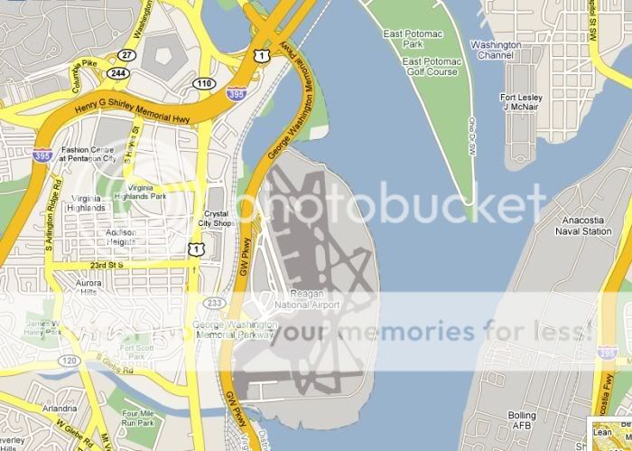
PS I know one version of the "official" flight path has Flight 77 beginning the circle well before the Pentagon, but I've seen other variations that have Flight 77 going OVER the Pentagon.
[edit on 10-5-2007 by nick7261]
If you look at the image below, you'll notice that not only is Reagan National Airport SE of the Pentagon, but so is Bolling Air Force Base. By now I think everybody knows that Flight 77 was alleged to have made a 330 degree, almost complete circle before crashing into the Pentagon.
My question is does anybody know where Flight 77's flight path would have taken it in relation to Reagan Airport and Bollings AFB? Was the turn tight enough that Flight 77 didn't go over Reagan Airport? Or was it a wider turn that took it out over the water near the AFB?
Also, if Flight 77 was circling directly over Reagan Airport, why did the controllers at Reagan Airport ask the C-130 that had taken off from Andrews AFB to visually locate Flight 77? Shouldn't the controllers at Reagan Airport have been able to see Flight 77 circling right in front of them?
Anybody want to draw Flight 77's official flight path on this map?
PS I know one version of the "official" flight path has Flight 77 beginning the circle well before the Pentagon, but I've seen other variations that have Flight 77 going OVER the Pentagon.
[edit on 10-5-2007 by nick7261]
Bolling AFB, per Wikipedia:
Take that for what it is - not sure what Bolling might have o do with this if anything
As for the map, we'd need a longer shot to see much of use - the plane was flying almost due east, according to official versions. 9/11 Comm wide path, closeup on the loop from NTSB, both from the DFDR:
Hope that helps, so whatcha got cooking?
The Air Force District of Washington (AFDW) was created and activated at Bolling on 1 October 1985 with the mission of providing administrative support to Air Force members. On 15 July 1994, AFDW was deactivated, but was reactivated 5 January 2005 to "provide a single voice for Air Force requirements in the National Capital Region" according to the base's website.
Take that for what it is - not sure what Bolling might have o do with this if anything
As for the map, we'd need a longer shot to see much of use - the plane was flying almost due east, according to official versions. 9/11 Comm wide path, closeup on the loop from NTSB, both from the DFDR:
Hope that helps, so whatcha got cooking?
Originally posted by Caustic Logic
Hope that helps, so whatcha got cooking?
I read a more detailed interview of the C-130 crew who witnessed Flight 77 hit the Pentagon. I was just wondering if their account matches up with the official story.
I thought I remembered the loop being well before the Pentagon, but then I have this notion that PF911T video showed 77 go OVER the Pentagon. I also have seen several versions of the flight path that show a different approach from the north. I believe these were constructed from eye-witness accounts.
It's interesting about Bolling be shut down pre-9/11 and then opened up again. It's probably a coincidence, but CSX has a rail line that goes right by the Shanksville crash site that was shut down pre-9/11 and re-opened after 9/11.
In case you didn't know, CSX has been a partner with the feds in owning a top secret complex at Greenbriar, WV. This is a resort that sits on top of a complete bunker that was to house the U.S. Congress in the event of a nuclear war. CSX owned the resort and was complicit in keeping the bunker secret.
I know this proves nothing, except that major corporations play along with the U.S. government in building and maintaining top secret facilities under a pre-text of legitimacy.
www.greenbrier.com...
Some interesting stuff there - site "R" I think it's called.
But as for the Pgon attack, all sources ow seem to agree on the loop. The final north-south orientation re:the Citgo is all in thhat final leg after the loop. The loop is tighter in the official story, a bit wider in the PentaCon / Pandora'sBlackBox version, leaving it a little to the north and then passing over the Pentagon at closer to a 90 degree angle.
It's interesting, they both agree on this northern trajectory but disagree on altitude: official story about 5 feet above ground, PentaCon about 80, just at flyover height, PBB has it 440 feet above ground, adjusted for reset discrepancy. Only one of these three can be correct.
And no one saw it fly over, or heard it fly over. Jet-explosion-silence is the sound pattern reported. Things to think about.
I looked at this a while ago, but my response was buried in another thread and I was new here and not much idea what was going on.
Great thread! I'd determined that had the aircraft flown over the Pentagon, it would have flown almost perpendicular to the river. Reagan National would have been immediately to the right of the aircraft.
I was interested in this because the aircraft WOULD have flown past the end of the runway at Reagan National. I can't find any weather data for Reagan to see which runways were in use. If I can find photos of Reagan National I'll post them up. I know where the tower is located on the airfield, and its elevation, but I don't know what the surroundings look like.
Airport Diagram
The tower and its elevation is marked on the chart.
The visual approach path to RW19 requires that pilots follow the river. Both the instrument approaches for RW15 and RW19 have aircraft flying down the SOUTH side of the river. This is to avoid the airspace over the Whitehouse from what I can gather. The required flight path is very close to the Pentagon (the aircraft fly past it on approach). The charts are available here: www.myairplane.com...
Boilling AFB doesn't exist (check Google Maps). I couldn't see a runway there, anyway.
From Flight 77 FDR, there is a strange DME being picked up at 3 miles IIRC. There are no DME stations to be received around 3 nm. DCA was 1.5nm from the Pentagon. The next nearest DME is out at 9nm. I thought it was possibly a secret DME station at the Whitehouse, but the DME distance does not tally (I put any possible Whitehouse DME at approximately 5.2nm).
[edit on 10-5-2007 by mirageofdeceit]
Originally posted by mirageofdeceit
Boilling AFB doesn't exist (check Google Maps). I couldn't see a runway there, anyway.
From Flight 77 FDR, there is a strange DME being picked up at 3 miles IIRC. There are no DME stations to be received around 3 nm. DCA was 1.5nm from the Pentagon. The next nearest DME is out at 9nm. I thought it was possibly a secret DME station at the Whitehouse, but the DME distance does not tally (I put any possible Whitehouse DME at approximately 5.2nm).
[edit on 10-5-2007 by mirageofdeceit]
Thanks MoD - I recall you and Lear talking about it I think. Funny that Google maps still shows what looks like a bse there in map (as Nick posted), but not in satellite (??). It's open now in some marginal way, but basically decommissioned before 9/11, which could be a clue (secret base anyone?) I didn't get what the DME stations were for before, but this is interesting. What do they do again? Help with direction finding?
Do you know of any cross-reference to the location of FL 77 on radar when the ATC first spotted it and its position in the loop? I remember the story
went something like FL 77 was 5 minutes away from Washington when ATC spotted it. Is this in Mineta's testimony?
Obviously the "5 minutes away" distance wouldn't include the loop time. Is there a way to put an X on the map to show where 77 might have been when it was spotted by ATC?
Obviously the "5 minutes away" distance wouldn't include the loop time. Is there a way to put an X on the map to show where 77 might have been when it was spotted by ATC?
There's a way but I don't know it. Find priphery of DC radar airspace? The loop took a few minutes, so it couldn't've been far out there.
I didn't get what the DME stations were for before, but this is interesting. What do they do again? Help with direction finding?
Yes. They are the radio equivalent of navigation beacons used by shipping to help find the coastlines, shipping lanes etc..
DME = Distance Measuring Equipment. The aircraft is equipped with an interrogator which interrogates the tuned station with a sequence of pulsed-pair signals (they are equally spaced). The ground station receives this interrogation, and transmits an identically sequenced signal in response. The time from transmission by the aircraft, to reception of the response is converted into a distance and displayed to the pilots. The pulses themselves are extremely precise. Each aircrafts DME transmitters have slightly different coded patterns they send out so they can identify their return pulses when re-transmitted by the ground station in response.
VOR = VHF Omni-directional Range. There are two signals broadcast by a VOR station. One signal is "static" and the other is rotated electronically. This creates an interference pattern. Basically, the aircraft receiving equipment compares the two signals, determines the phase-angle between the two, and from this, can determine its position relative to the transmitting station. The VOR is calibrated relative to local magnetic north.
Quite often VOR and DME stations are co-located, so an aircraft has both range and position data relative to the beacon, so an aircraft can determine its position. A pilot then uses that information to look on a chart and find out where he is.
EDIT: The DC controllers saw it on RADAR then, not visually? With the orbit that it made, DCA controllers should have been able to see it????? It would have been in their airspace, surely?!
[edit on 10-5-2007 by mirageofdeceit]
Someone may have visually seen it, I dunno. Danielle O'Brien saw it on her screen, but I think that was her job to watch that.
Video of her talking about it:
hope the link works - if not here's the URL
video.google.com... &q=%22flight+77%22&hl=en
Thanks for the DME info - I'll go back and see where that's shown in the FDR data.
Could be relevant.
Video of her talking about it:
Google Video Link |
hope the link works - if not here's the URL
video.google.com... &q=%22flight+77%22&hl=en
Thanks for the DME info - I'll go back and see where that's shown in the FDR data.
Could be relevant.
I've taken the liberty to increase the size of and slightly edit your map.
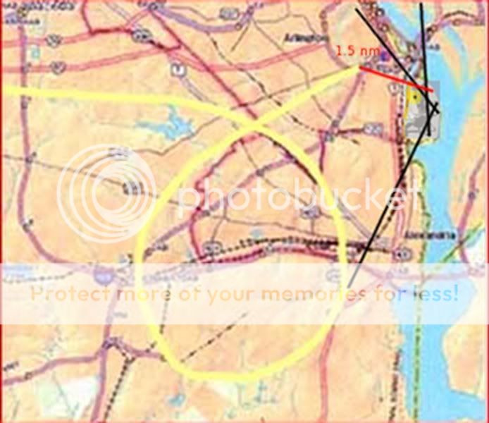
The red line is the last DME distance of DME1 in the Flight 77 FDR. DME2 from the FDR can't be drawn as its position is unknown. The black lines are extended runways showing the relative approach paths for the airport. The faint yellow circle with the blue dot on the airport is the control tower position.
As you can see, DCA had a lot of reasons to (want?) to know where Flight 77 was and what he was doing. Based on general airport ops, he was well inside of DCA tower airspace, and they should have had a clear view of him due to his proximity to the airport.
[edit on 10-5-2007 by mirageofdeceit]
There's still something that doesn't seem right about this whole C-130 flight path.
According to the story, the C-130 had just taken off from Andrews AFB almost at the exact time the ATC saw Flight 77 coming into D.C. at 500+ mph. The ATC asked the C-130 for a visual, and the C-130 pilot said that FL 77 was right in front of him.
When looking at the map, the question that immediately comes to my mind is why did the C-130 have a flight path that took it directly over Reagan International? Am I missing something, or is the only way the C-130 could have seen FL 77 is if it made a bee-line right for the Pentagon, which would have taken it right over Reagan International airspace?
Here's a map:
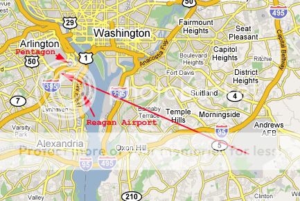
Originally posted by Caustic Logic
Someone may have visually seen it, I dunno. Danielle O'Brien saw it on her screen, but I think that was her job to watch that.
Video of her talking about it:
Google Video Link
hope the link works - if not here's the URL
video.google.com... &q=%22flight+77%22&hl=en
Thanks for the DME info - I'll go back and see where that's shown in the FDR data.
Could be relevant.
CL,
Great video!
Only problem is that it makes me scratch my head even more.
At about 9:20 in the video Danielle O'Brien says she thinks the hijackers flew over the Pentagon, or at least approached very close to it on their first pass.
Also, she was very specific that FL 77 turned away 3 miles out. 3 miles out from what? She made it seem like the White House, but that wouldn't jive with the official flight path. If FL 77 started its turn 3 miles out it almost surely would have gone right over Reagan International, right?
Also, how is it that she wasn't warning all the other aircraft to get out of the way of FL 77? Why didn't they call in to Reagan National ATC? And out of all the aircraft in the area, how is it that the ATC picked the C-130 to see if it could spot FL 77?
There certainly are a lot of questions about this flight path...
Originally posted by nick7261
At about 9:20 in the video Danielle O'Brien says she thinks the hijackers flew over the Pentagon, or at least approached very close to it on their first pass.
I'm not seeing that at 9:20 or any clue of flyover anywhere in that video.
Also, she was very specific that FL 77 turned away 3 miles out. 3 miles out from what? She made it seem like the White House, but that wouldn't jive with the official flight path.
I think she means 3 miles out from her at the tower? It was MUCH further from the White House. Her thots about them going for the Pentagon cause they couldn't see the White House is just silly. Plus the planner wouldn't do that anyway, it was too "Independence Day" already.
If FL 77 started its turn 3 miles out it almost surely would have gone right over Reagan International, right?
Depends which way they turned. The turn did happen a few miles out and it didn't go over the airport, so I guess not.
Also, how is it that she wasn't warning all the other aircraft to get out of the way of FL 77? Why didn't they call in to Reagan National ATC? And out of all the aircraft in the area, how is it that the ATC picked the C-130 to see if it could spot FL 77?
There certainly are a lot of questions about this flight path...
Those I can't say. A lot of questions, and good job on keeping them coming. I'll have to come back later, my appetite for mystery is well whetted.
Originally posted by Caustic Logic
Originally posted by nick7261
At about 9:20 in the video Danielle O'Brien says she thinks the hijackers flew over the Pentagon, or at least approached very close to it on their first pass.
I'm not seeing that at 9:20 or any clue of flyover anywhere in that video.
Ok, start at 8:45 where she talks about going to the Pentagon and standing on the hill imagining where the plane would have been according to what she saw on radar. She talks about the sun being in their eyes and how they couldn't spot the White House, but instead saw the Pentagon. She said something about them flying over or approaching the Pentagon.
Also, she was very specific that FL 77 turned away 3 miles out. 3 miles out from what? She made it seem like the White House, but that wouldn't jive with the official flight path.
I think she means 3 miles out from her at the tower? It was MUCH further from the White House. Her thots about them going for the Pentagon cause they couldn't see the White House is just silly. Plus the planner wouldn't do that anyway, it was too "Independence Day" already.
I'm not so sure about this. They were very specific about calling the White House -not the Capitol or anywhere else. My impression from watching the video is that the plane was 3 miles from the White House when it turned around. That doesn't mean that interpretation is accurate -it's just the impression I got.
If FL 77 started its turn 3 miles out it almost surely would have gone right over Reagan International, right?
Depends which way they turned. The turn did happen a few miles out and it didn't go over the airport, so I guess not.
Now we're getting into the realm of deciding what evidence is reliable. How can we be certain that 77 didn't go over Reagan? I know the FDR data has become accepted as an accurate representation of the flight path, but there are also those who question its validity.
Also, how is it that she wasn't warning all the other aircraft to get out of the way of FL 77? Why didn't they call in to Reagan National ATC? And out of all the aircraft in the area, how is it that the ATC picked the C-130 to see if it could spot FL 77?
There certainly are a lot of questions about this flight path...
Those I can't say. A lot of questions, and good job on keeping them coming. I'll have to come back later, my appetite for mystery is well whetted.
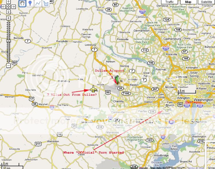
Here's a map I did in Google of Dulles, along with a couple of locations where "3 miles out" could have been.
One thing I noticed is that if the official flight path is correct, then Flight 77 wasn't heading towards the White House when it was 3 miles out. It was heading more in line with the Pentagon, or maybe even heading SE at 3 miles out beginning it's turn.
There is a lot of data re Flight 77's path, but much of it seems contradictory. What makes this analysis interesting, imo, is how it relates to the whole concept of how FL 77 was able to go into downtown D.C. totally unimpeded in the first place.
Was the air traffic around Reagan already cleared in anticipation of FL 77's arrival? Why are there no reports from commerical pilots seeing FL 77?
Originally posted by nick7261
She said something about them flying over or approaching the Pentagon.
Pretty sure it was approaching
Now we're getting into the realm of deciding what evidence is reliable. How can we be certain that 77 didn't go over Reagan? I know the FDR data has become accepted as an accurate representation of the flight path, but there are also those who question its validity.
There are aspects and whole pieces of evidence I doubt, but just about everything agrees on this general path and loop. If you have any good reson to suspect is was over, or headed over Regan I'll consider it.
Here's a map I did in Google of Dulles, along with a couple of locations where "3 miles out" could have been.
One thing I noticed is that if the official flight path is correct, then Flight 77 wasn't heading towards the White House when it was 3 miles out. It was heading more in line with the Pentagon, or maybe even heading SE at 3 miles out beginning it's turn.
Agreed. Whyever it's so, O'Brien's White house centered drama seems all in her head. This plane was gunning for the newly-rnovated side of the Pentagon since it turned around over Ohio.
Okay maybe she thought it was going tp fly over the Pgon, which it would if going to the White House. And maybe it was headed that way - who
can know what's goin on in the mind of the hijacker (Islamic or digital)? Maybe a new signal from the Pgon snagged it there, threw it off on a sprial
loop (a good way to drop altitude without losing much position) and dropped it into the bunker unexpectedly?
More intriguing thoughts, but I need to get going now
More intriguing thoughts, but I need to get going now
I've been looking through the archives of the news reports back in 2001. There seems to be different stories about the flight path. I recall at the
time it was understood that FL 77 came in along the river. The original news stories confirm this.
It's also interesting that Ari Fleischer claims that the White House saw different radar info that what was being officially reported. Here's the story and the link:
www.cbsnews.com...
It's also interesting that Ari Fleischer claims that the White House saw different radar info that what was being officially reported. Here's the story and the link:
www.cbsnews.com...
(CBS) New radar evidence obtained by CBS News strongly suggests that the hijacked jetliner which crashed into the Pentagon hit its intended target.
Top government officials have suggested that American Airlines Flight 77 was originally headed for the White House and possibly circled the Capitol building. CBS News Transportation Correspondent Bob Orr reports that's not what the recorded flight path shows.
Eight minutes before the crash, at 9:30 a.m. EDT, radar tracked the plane as it closed to within 30 miles of Washington. Sources say the hijacked jet continued east at a high speed toward the city, but flew several miles south of the restricted airspace around the White House.
At 9:33 the plane crossed the Capitol Beltway and took aim on its military target. But the jet, flying at more than 400 mph, was too fast and too high when it neared the Pentagon at 9:35. The hijacker-pilots were then forced to execute a difficult high-speed descending turn.
Radar shows Flight 77 did a downward spiral, turning almost a complete circle and dropping the last 7,000 feet in two-and-a-half minutes.
The steep turn was so smooth, the sources say, it's clear there was no fight for control going on. And the complex maneuver suggests the hijackers had better flying skills than many investigators first believed.
The jetliner disappeared from radar at 9:37 and less than a minute later it clipped the tops of street lights and plowed into the Pentagon at 460 mph.
Some eyewitnesses believe the plane actually hit the ground at the base of the Pentagon first, and then skidded into the building. Investigators say that's a possibility, which if true, crash experts say may well have saved some lives.
At the White House Friday, spokesman Ari Fleischer saw it a different way.
"That is not the radar data that we have seen," Fleischer said, adding, "The plane was headed toward the White House."
Ten days after the hijacked airliner slammed into the Pentagon, leaving 189 people dead or missing including those on the plane, and gouging a giant smoky slice out of the world's biggest office building, some 300 people were looking for clues.
Officials said no survivors had been taken out of the building since the day of the crash and 104 people have been identified.
Rescue crews have turned over the operational control of the crash site to the FBI. The transfer clears the way for the criminal investigation to intensify.
Additional human remains are expected to be recovered during the criminal investigation at the site, which could last for a month.
The fire chief in Arlington County, Va., says all areas of the Pentagon (with the exception of the fourth- and fifth-floor corridors of the three outer rings) have been released to the Department of Defense.
The last civilian urban search-and-rescue team was leaving the site Friday.
Military engineers from the Army's Fort Belvoir completed their work Friday morning
CL,
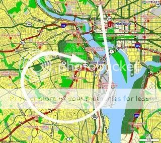
Here's an image I pulled from The Guardian's website from sometime near 9/11. This was the original flight path that was published back in 2001.
Also, here's an interesting article from Boston.com from Nov. 2001.
www.boston.com...
Do any of these conflicting reports on the flight path make any sense in terms of your research?
Here's an image I pulled from The Guardian's website from sometime near 9/11. This was the original flight path that was published back in 2001.
Also, here's an interesting article from Boston.com from Nov. 2001.
www.boston.com...
Because the plane's transponder was turned off, it was hard for controllers to track the plane precisely, but ultimately the controller who cleared the plane out of Dulles watched his scope as the aircraft flew back toward Washington.
Authorities contend that Hanjour was at the controls and that the plane may have been on autopilot.
Controllers say the plane crossed the Pentagon at 7,000 feet and then made a sweeping circle to the right, during which time it dropped down to near surface level.
Do any of these conflicting reports on the flight path make any sense in terms of your research?
Authorities contend that Hanjour was at the controls and that the plane may have been on autopilot.
?!?!?!
Why would they say that?
new topics
-
Bobiverse
Fantasy & Science Fiction: 2 hours ago -
Florida man's trip overseas ends in shock over $143,000 T-Mobile phone bill
Social Issues and Civil Unrest: 2 hours ago -
Former Labour minister Frank Field dies aged 81
People: 4 hours ago -
SETI chief says US has no evidence for alien technology. 'And we never have'
Aliens and UFOs: 6 hours ago -
This is our Story
General Entertainment: 8 hours ago -
President BIDEN Vows to Make Americans Pay More Federal Taxes in 2025 - Political Suicide.
2024 Elections: 11 hours ago -
Ode to Artemis
General Chit Chat: 11 hours ago
top topics
-
President BIDEN Vows to Make Americans Pay More Federal Taxes in 2025 - Political Suicide.
2024 Elections: 11 hours ago, 14 flags -
Should Biden Replace Harris With AOC On the 2024 Democrat Ticket?
2024 Elections: 17 hours ago, 6 flags -
One Flame Throwing Robot Dog for Christmas Please!
Weaponry: 15 hours ago, 6 flags -
Florida man's trip overseas ends in shock over $143,000 T-Mobile phone bill
Social Issues and Civil Unrest: 2 hours ago, 5 flags -
Don't take advantage of people just because it seems easy it will backfire
Rant: 15 hours ago, 4 flags -
Ditching physical money
History: 15 hours ago, 4 flags -
SETI chief says US has no evidence for alien technology. 'And we never have'
Aliens and UFOs: 6 hours ago, 4 flags -
Former Labour minister Frank Field dies aged 81
People: 4 hours ago, 4 flags -
Ode to Artemis
General Chit Chat: 11 hours ago, 3 flags -
This is our Story
General Entertainment: 8 hours ago, 3 flags
active topics
-
President BIDEN Vows to Make Americans Pay More Federal Taxes in 2025 - Political Suicide.
2024 Elections • 51 • : Scratchpost -
SETI chief says US has no evidence for alien technology. 'And we never have'
Aliens and UFOs • 24 • : mysterioustranger -
Suspended Nigerian Poverty Minister had $24M in her Bank Accounts
Political Issues • 11 • : malamarabi -
Should Biden Replace Harris With AOC On the 2024 Democrat Ticket?
2024 Elections • 47 • : Cvastar -
Florida man's trip overseas ends in shock over $143,000 T-Mobile phone bill
Social Issues and Civil Unrest • 2 • : mysterioustranger -
Post A Funny (T&C Friendly) Pic Part IV: The LOL awakens!
General Chit Chat • 7133 • : underpass61 -
VirginOfGrand says hello
Introductions • 2 • : TheMichiganSwampBuck -
Thousands Of Young Ukrainian Men Trying To Flee The Country To Avoid Conscription And The War
Other Current Events • 128 • : twistedpuppy -
The Reality of the Laser
Military Projects • 37 • : DronesandUFOs -
Breaking Baltimore, ship brings down bridge, mass casualties
Other Current Events • 476 • : IndieA