It looks like you're using an Ad Blocker.
Please white-list or disable AboveTopSecret.com in your ad-blocking tool.
Thank you.
Some features of ATS will be disabled while you continue to use an ad-blocker.

Question: Was this GoogleMap Image Altered on purpose?
page: 2share:
great find gfad!
Although I didn't see the building you mentioned at first, I do see an object to the northwest that appears that it could be a five sided object...maybe that is what you are talking about...
It struck me as either something like you said, or even a sattelite?
Also, to the northeast about the same distance from the center as the five sided object, I see a white triangle pointing southward...If you zoom in a couple times, it is more evident...Do you see this? It almost resembles your mouse cursor in shape..My thoughts are that it may be an aircraft of some type....
This is getting very interesting..
Has anyone got a screen capturing program in case this gets taken down from Flash Earth?
Why would it be obviously blurred in one source, and obviously blacked out in another?
[edit on 11-4-2007 by Azazelus]
I noticed a simliar blacked out area on Google maps, of an area of Greenland. stood out as most of the continent is white!
maps.google.com...,-42.802734&spn=3.621801,14.80957&t=h&om=1
[edit on 11/4/2007 by Mukiwa]
maps.google.com...,-42.802734&spn=3.621801,14.80957&t=h&om=1
[edit on 11/4/2007 by Mukiwa]
Ok., checking coordinated on the two sites this is very close. However, if in fact what I have found is a lake, then the question remains WHAT IS
blurred out on the original post? Have you been able to find it? I am still looking without any luck.
Ok I Just checked coordinates...And they are unfortuneately not the same
My coordinates= 67.51293602 lat/172.17396561 long
ok I'm re-checking because you may have a point. I am having a really hard time finding the exact coordinates of eh=whatever it is that is blurred out!
you are obviously seeing the small lake up and to the west I am closer to the shore, farther east. Check the latitude and longitude,I believe we at different locations, they are different. Good work though. If more people can triangulate the way you did, we will have this figured out in no time.
I will keep trying, I think they are different locations
[edit on 11-4-2007 by theutahbigfoothunter]
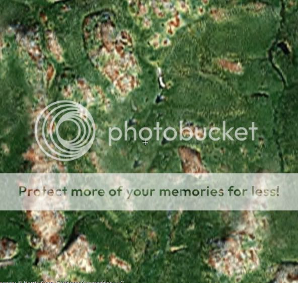
Heres a screencap of the image. Ive outlined the area which is black on the Yahoo image and also circled what I think appears to be a building with 5
lobes on it. As far as I can see it is the only building in the area.
The TerraServer image is not even close. The "UFO" is a lake. If you notice the TerraServer site says the image is from 1991. Anyhow, used the
Long./Lat. to locate by cross referencing Google Earth. The coordinates are shown on the screen shot. Here's the two corresponding pics:
GoogleEarth:
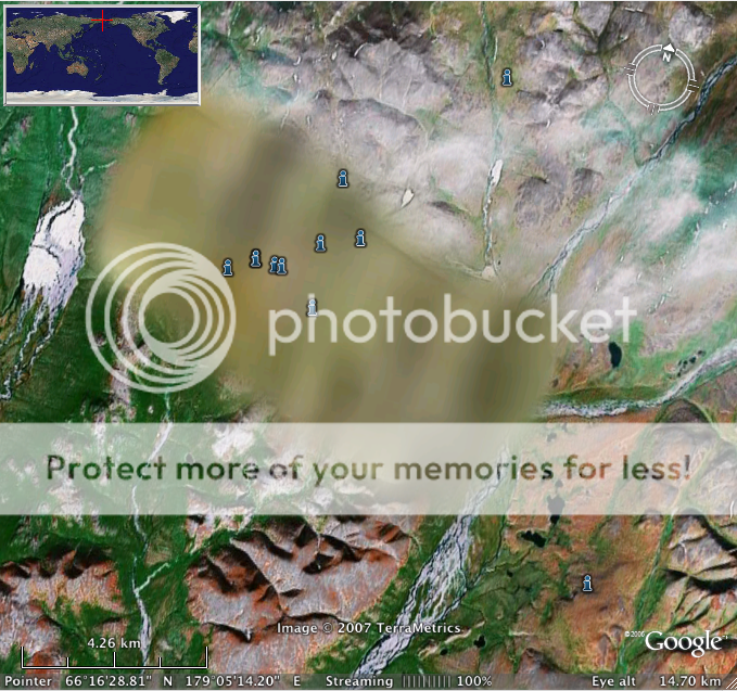
TerraServer:
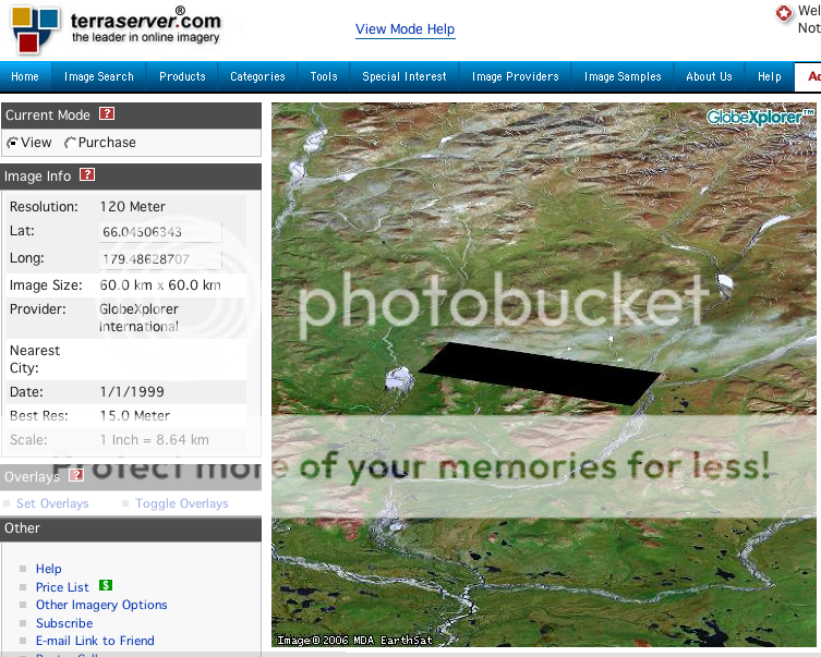
GoogleEarth:
TerraServer:
I am actually more suspicious of the giant hole to the south east of the 'building' in the posted picture. Its about equal length away from the
crosshair as the 'building'. That black spot or 'hole' may be something in itself that HAD to be blacked out. If that image has not been edited
and the black spot is infact a hole then I would suspect it to be an underground cannon. It would be used to shoot nukes in a protective casing too
heavy to drop or launch in the conventional sense.
G.F.A.D. - why you gotta be punking me out like that?!
guess I'm a little too slow.
thanks for the link to flashearth though. didn't know about that site.
guess I'm a little too slow.
thanks for the link to flashearth though. didn't know about that site.
You Are right! Darn I hate defeat....But you are right I just got more satellite recogniton, and focused in using a terraserver platform recently
downloaded. Good work there. The Lats and Longs are way close to the ones in Google earth. But not the same. That building is very interesting. What
do you make of it? Hmmm...Whether this proves or disprooves anything, Well, who knows. But I am still interested. Let me know if anything else comes
up. Awesome Work!
- Man, I still hate it when they blurr stuff out !
What the heck are they hiding from us?
BTW the Flashsite is awesome! Thanks
[edit on 11-4-2007 by theutahbigfoothunter]
- Man, I still hate it when they blurr stuff out !
What the heck are they hiding from us?
BTW the Flashsite is awesome! Thanks
[edit on 11-4-2007 by theutahbigfoothunter]
That triangle is interesting. What about this pattern of four strange shapes, each one identical:
Im highly skeptical of a "nuclear cannon"! That theory just doesnt make sense, but something is obviously being hidden here.
Im highly skeptical of a "nuclear cannon"! That theory just doesnt make sense, but something is obviously being hidden here.
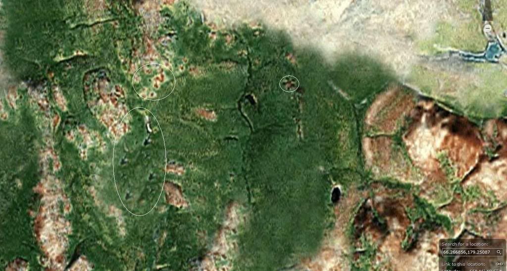
OK sorry guys but I think even the microft imagery we are looking at is faked aswell. Look at this image, the two areas I have circled are both
EXACTLY on the boundary of the Yahoo blackout and Google blur. The mountains dont match up, the river doesnt run into anything. The microsoft image
has been totally edited by the powers from above as well!!
Gfad, I'm inclined to think that those repeating shapes are the after effect of image editing.
Whenever you use a program such as photoshop to edit an image, say, if I was editing a picture of a model's face to remove a pimple, I couldn't just paint over that pimple with "flesh" color - that would be instantly obvious, since the texture wouldn't match. What I *would* do, would be to clone an area of the image that is roughly the same in hue. When you do this, with a "magic wand" type tool, you select a starter point, and then you start to paint, and the two brushes move in parallel, magically erasing the pimple with skin-toned and textured pixels that *isn't* obvious. Later versions of photoshop etc have perfected this tool so it works even better.
But say, for example, when doing this I picked an area of her face that had a mole on it. The mole would be repeated over and over in the small area I was painting, a common mistake if you're a new user.
See, if you look at the image you posted, not only are the shapes repeated, but there are shapes near them that are also repeated.. Classic mistake.. You've accidentally re-cloned some artifact from your original "clean" area of the image..
It's something I've done many times by accident, and had to fix, when editing an image. (Photoshopping things is a hobby)
The greenland one is weird.. measures about 2 miles by 25 miles..
What would cover that sort of an area? Only thing I can think of is something like a runway?
[edit on 11-4-2007 by Inannamute]
I completely agree, I use photoshop quite a bit and am familiar with the tools. Cloning a distinguishing feature is the biggest rookie mistake in the
book.
Im just amazed that a government agent would make such a mistake when covering up a facility. Surely you would just clone some of the green from the surrounding area!!
Im just amazed that a government agent would make such a mistake when covering up a facility. Surely you would just clone some of the green from the surrounding area!!
Originally posted by gfad
Im highly skeptical of a "nuclear cannon"! That theory just doesnt make sense, but something is obviously being hidden here.
Uggh! I wish I knew what it was called. The cannon concept is being used as an alternative to launching rockets in achieving satellite orbit. During the Cold War it could have been a 'Black Project' until ICBMS and bombers were technically sufficent enough. ALSO, even if a global EMP fried everything but intentionally 'Ruggedized' equiptment you could still launch nukes. Mathematically sloving angles and theoretical charge necessities would allow a densely armored solid 'nuclear bullet' to be shot at predetermined locations. Depending on the scale of such an operation, this theoretical cannon could deliver MASSIVE nukes of last resort.
I forget the name of the town but I believe a 'test round' has already hit America. I think it was in the 1950's or so but could be wrong. Some rural area had something crash in the woods and the military came and confiscated it. I saw it on the History channel a while back but never made the connection. Depending on if and when such a cannon was developed would change a lot of foreign relations.
If anyone knows the incident in the woods im talking about please let me know.
Sorry I'm so off topic on altering google or yahoo. The four identical shapes you mentioned gfad do look to be 'layerd'. Good eye though. Doesnt Area 51 have blacked out circles on it or are thoes water sheds of sorts? What do you guys think about blacking out or altering google?
Another source
Note to the mod: I beleive the second link from the originating post was accidentally modified to shorten it ...but the link is wrong now here is the
yahoo link I intended to post
Original Yahoo Link
[edit on 4/11/2007 by a1ex]
Note to the mod: I beleive the second link from the originating post was accidentally modified to shorten it ...but the link is wrong now here is the
yahoo link I intended to post
Original Yahoo Link
[edit on 4/11/2007 by a1ex]
There are some strange features of this area in question. This almost feels like the mars or moon anomaly thread
The strange features:
1) Strange shapes in a pattern of four (4x). These 4 shapes seem to be identical, and it's not some natural shape that can be explained away, it is an ODD shape. This shape is seemingly patterned or copied in a pattern of 4 shapes grouped together. Any ideas?
2) Four or Five lobed feature or structure. This looks like there can be a change in elevation associated with the 'peak' of the lobed structure, similar to a pyramid rising to a point.
3) 'Letter N-Z' shape found in the image. This looks to be a canyon or indentation of some sort in a peculiar shape. This is one feature that is questionable, may be natural feature...What do you think?
There are some other possible anomalies in the image, however in my view some can be natural so I did not circle these. In another post, someone stated that 'the big hole in the image'. This is just a lake, some other lakes with similar looking features are found near the oval dark 'hole' as stated.
So what do you all think, this may be a stumble upon that needs more peoples pupils looking at! After all this is an image that was blurred on google Earth and Google Maps, and blocked out on another server.
[edit on 11-4-2007 by greatlakes]
[edit on 11-4-2007 by greatlakes]
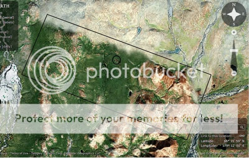
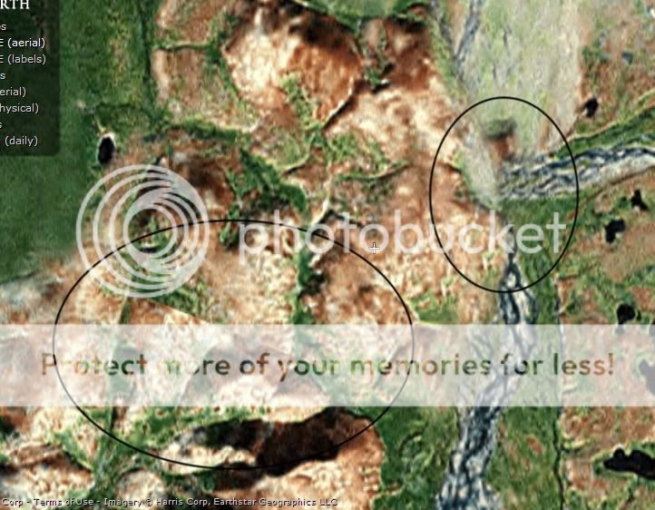
Looking at the 66.266856,179.25087 coordinates on flash earth with microsoft VE, the obvious thing to notice is the northeastern face of the border of
the blurred area.
It looks to have been photoshopped, because the greener area meets with the tan area in a very suspicious way, especially given the fact that this border coincides exactly with the border of the blurred area.
Also, if you have microsoft VE (labels) on, and you zoom in far enough, you can see a label, which appears to read 'CHUKOT'. Wierd, huh?
Did anyone else notice this?
I know this isn't directly related but I thought it was appropriate to add it to this thread...
Google map edit
Now this is literally a mile and a half away from my house. Anybody got any idea what this is?
Google map edit
Now this is literally a mile and a half away from my house. Anybody got any idea what this is?
If it's close to your house, go take a look and see what's there?
Take pictures, too.. Might give clues as to the reason there are other map edits - eg. are the blank areas ones for which there *is* no data due to technical glitches, or are these user inserted blackspots..
You can also try the different imaging services, see if they're *all* blacked out or blurred out..
new topics
-
George Knapp AMA on DI
Area 51 and other Facilities: 4 hours ago -
Not Aliens but a Nazi Occult Inspired and then Science Rendered Design.
Aliens and UFOs: 4 hours ago -
Louisiana Lawmakers Seek to Limit Public Access to Government Records
Political Issues: 7 hours ago -
The Tories may be wiped out after the Election - Serves them Right
Regional Politics: 8 hours ago -
So I saw about 30 UFOs in formation last night.
Aliens and UFOs: 10 hours ago -
Do we live in a simulation similar to The Matrix 1999?
ATS Skunk Works: 11 hours ago -
BREAKING: O’Keefe Media Uncovers who is really running the White House
US Political Madness: 11 hours ago
top topics
-
BREAKING: O’Keefe Media Uncovers who is really running the White House
US Political Madness: 11 hours ago, 24 flags -
George Knapp AMA on DI
Area 51 and other Facilities: 4 hours ago, 19 flags -
Biden--My Uncle Was Eaten By Cannibals
US Political Madness: 12 hours ago, 18 flags -
African "Newcomers" Tell NYC They Don't Like the Free Food or Shelter They've Been Given
Social Issues and Civil Unrest: 17 hours ago, 12 flags -
"We're All Hamas" Heard at Columbia University Protests
Social Issues and Civil Unrest: 12 hours ago, 7 flags -
Louisiana Lawmakers Seek to Limit Public Access to Government Records
Political Issues: 7 hours ago, 7 flags -
Russian intelligence officer: explosions at defense factories in the USA and Wales may be sabotage
Weaponry: 16 hours ago, 6 flags -
So I saw about 30 UFOs in formation last night.
Aliens and UFOs: 10 hours ago, 5 flags -
The Tories may be wiped out after the Election - Serves them Right
Regional Politics: 8 hours ago, 3 flags -
Not Aliens but a Nazi Occult Inspired and then Science Rendered Design.
Aliens and UFOs: 4 hours ago, 3 flags
active topics
-
George Knapp AMA on DI
Area 51 and other Facilities • 16 • : Brotherman -
Election Year 2024 - Interesting Election-Related Tidbits as They Happen.
2024 Elections • 64 • : Zanti Misfit -
Biden--My Uncle Was Eaten By Cannibals
US Political Madness • 45 • : RazorV66 -
Truth Social goes public, be careful not to lose your money
Mainstream News • 119 • : Kaiju666 -
Candidate TRUMP Now Has Crazy Judge JUAN MERCHAN After Him - The Stormy Daniels Hush-Money Case.
Political Conspiracies • 383 • : xuenchen -
OUT OF THE BLUE Chilling moment pulsating blue cigar-shaped UFO is filmed hovering over PHX AZ
Aliens and UFOs • 42 • : Ophiuchus1 -
-@TH3WH17ERABB17- -Q- ---TIME TO SHOW THE WORLD--- -Part- --44--
Dissecting Disinformation • 531 • : cherokeetroy -
So I saw about 30 UFOs in formation last night.
Aliens and UFOs • 20 • : Halfswede -
MULTIPLE SKYMASTER MESSAGES GOING OUT
World War Three • 33 • : Halfswede -
Not Aliens but a Nazi Occult Inspired and then Science Rendered Design.
Aliens and UFOs • 7 • : JonnyC555