It looks like you're using an Ad Blocker.
Please white-list or disable AboveTopSecret.com in your ad-blocking tool.
Thank you.
Some features of ATS will be disabled while you continue to use an ad-blocker.

google earth censor in siberia
page: 10
share:
maybe this has been posted before, dont know.
go here:
66 16 30.01 N
179 12 33.60 E
a place in siberia not too terribly far from the region close to alaska, its not a blackout, this is straight up blurred out, like its a base being censored, maybe someones got some info?
go here:
66 16 30.01 N
179 12 33.60 E
a place in siberia not too terribly far from the region close to alaska, its not a blackout, this is straight up blurred out, like its a base being censored, maybe someones got some info?
IMHO , most likley a technicians thumb print or glitch - it is translucent , not blurred
What about Antartica? Why can't I get a decent close up view of that continent? Everytime I try to zoom in I get the following message:
"Unable to view at that level" or some similar message which I don't exactly remember now!
"Unable to view at that level" or some similar message which I don't exactly remember now!
check out green land( i dont know if this has been posted) its weird but i dont think to much of it go here -------> 60 44'27.76"n 46
15'25.46"w
[edit on 4-3-2007 by miguelbmx]
[edit on 4-3-2007 by miguelbmx]
Originally posted by SocialistAgenda
What about Antartica? Why can't I get a decent close up view of that continent?
Why should you be able to get a close up of antarctica? Google Maps/Earth is collected statellite data, there isn't going to be much public interest in mapping antarctica, people tend not to travel there much.
Originally posted by Nygdan
Originally posted by SocialistAgenda
What about Antartica? Why can't I get a decent close up view of that continent?
Why should you be able to get a close up of antarctica? Google Maps/Earth is collected statellite data, there isn't going to be much public interest in mapping antarctica, people tend not to travel there much.
Does that mean that only "popular" areas get coverage? What about the north and south poles? There are many reasons I am interested in getting relatively close ups...but mainly too see the ice shelfs and second I would like to see the alleged research facilities there operated by several countries! Is this prohibited?
i have been to CFS ALERT up on ellsmere island and when i tried to find it on google earth and it was just a dot with a name, same with THULE Airforce
Base in Greenland (everything else is sharp and clear )
i even checked out my own area and the base is sharp and clear(CFB Gagetown just outside Fredricton New Brunswick) the image was about 3-4 yrs. old lol.
i even checked out my own area and the base is sharp and clear(CFB Gagetown just outside Fredricton New Brunswick) the image was about 3-4 yrs. old lol.

So the Russians got them to censor a military base on national security grounds...so what?
I just want to point out that the data on Google Earth is not current. It is at least a year old. What you find there may not be
there now. I know this by googling my own address where I get a picture showing a mesquite tree in my front yard that I had to cut down over a year
ago.
I really miss that tree.
[edit on 8-8-2007 by groingrinder]
I really miss that tree.
[edit on 8-8-2007 by groingrinder]
It would be great for Google Earth to map Antartica just to see if there is a big hole there and maybe green forests
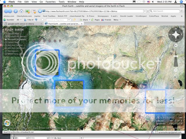
Flash Earth shows it. It's nothing at first glance, but looking
closer it almost looks airbrushed in. Check out the river to the right, all those tributaries just appearing out of nowhere.
Originally posted by howie0
i have been to CFS ALERT up on ellsmere island and when i tried to find it on google earth and it was just a dot with a name, same with THULE Airforce Base in Greenland (everything else is sharp and clear )
Nothing much to say about Thule. My uncle used to work there for a couple of years, and he took tons of pictures while there. Showed them gladly when he got home. So they can't have too many secrets up there
Originally posted by Quasar
Flash Earth shows it. It's nothing at first glance, but looking closer it almost looks airbrushed in. Check out the river to the right, all those tributaries just appearing out of nowhere.
If the map looks airbrushed, that's because it is. Or, more accurately .. it's clone stampped.
It's evident in the places I've highlighted here:
For an example of clone stampping, I've demonstrated below. Notice I've cloned a section of the car onto the door. And to mimic the shotty work done on the map, I've placed a small clone stamp just a little off center to start the cloning. This is was has been done in the photos where I've highlighted. Can you find them?


Yup, definately cloned. I play with photoshop too, and know how valuable of a tool that is. I didn't see that, why would they clone something that
close? I would have brought something in from miles away.
new topics
-
HORRIBLE !! Russian Soldier Drinking Own Urine To Survive In Battle
World War Three: 40 minutes ago -
Bobiverse
Fantasy & Science Fiction: 3 hours ago -
Florida man's trip overseas ends in shock over $143,000 T-Mobile phone bill
Social Issues and Civil Unrest: 3 hours ago -
Former Labour minister Frank Field dies aged 81
People: 5 hours ago -
SETI chief says US has no evidence for alien technology. 'And we never have'
Aliens and UFOs: 7 hours ago -
This is our Story
General Entertainment: 10 hours ago
top topics
-
President BIDEN Vows to Make Americans Pay More Federal Taxes in 2025 - Political Suicide.
2024 Elections: 12 hours ago, 16 flags -
One Flame Throwing Robot Dog for Christmas Please!
Weaponry: 16 hours ago, 6 flags -
Florida man's trip overseas ends in shock over $143,000 T-Mobile phone bill
Social Issues and Civil Unrest: 3 hours ago, 6 flags -
SETI chief says US has no evidence for alien technology. 'And we never have'
Aliens and UFOs: 7 hours ago, 5 flags -
Don't take advantage of people just because it seems easy it will backfire
Rant: 17 hours ago, 4 flags -
Ditching physical money
History: 16 hours ago, 4 flags -
Former Labour minister Frank Field dies aged 81
People: 5 hours ago, 4 flags -
Bobiverse
Fantasy & Science Fiction: 3 hours ago, 3 flags -
This is our Story
General Entertainment: 10 hours ago, 3 flags -
Ode to Artemis
General Chit Chat: 13 hours ago, 3 flags
active topics
-
The Reality of the Laser
Military Projects • 40 • : Zaphod58 -
HORRIBLE !! Russian Soldier Drinking Own Urine To Survive In Battle
World War Three • 6 • : CarlLaFong -
President BIDEN Vows to Make Americans Pay More Federal Taxes in 2025 - Political Suicide.
2024 Elections • 67 • : UnderAether -
-@TH3WH17ERABB17- -Q- ---TIME TO SHOW THE WORLD--- -Part- --44--
Dissecting Disinformation • 642 • : Thoughtful3 -
Windows tracking links to WEF and more:
New World Order • 21 • : milaganenogan -
SETI chief says US has no evidence for alien technology. 'And we never have'
Aliens and UFOs • 29 • : SchrodingersRat -
"We're All Hamas" Heard at Columbia University Protests
Social Issues and Civil Unrest • 274 • : YourFaceAgain -
Manly P. Hall says Freemasonry is a religion?
Secret Societies • 21 • : SchrodingersRat -
Florida man's trip overseas ends in shock over $143,000 T-Mobile phone bill
Social Issues and Civil Unrest • 4 • : VariedcodeSole -
How ageing is" immune deficiency"
Medical Issues & Conspiracies • 28 • : SchrodingersRat
0