It looks like you're using an Ad Blocker.
Please white-list or disable AboveTopSecret.com in your ad-blocking tool.
Thank you.
Some features of ATS will be disabled while you continue to use an ad-blocker.

Lunar Strip Mine in John Lear's Moon Photos??
page: 2share:
Not saying I believe this but these places I marked sure do look remarkably like cranes. Could just be seeing things though I guess.


Originally posted by mikesingh
I don't see any indications of such tracks. Or how is the soil being scooped out from the bottom? This is just a meteor which has smashed to dust on the surface.
Granted, the violence and kinetic energy of a massive meteor impact can certainly melt rock and cause all manner of formations.
On the other hand, there are some compelling features that have unique parallels.

en.wikipedia.org...
If this is a surface mining site, I think it's ancient.
Originally posted by SkepticOverlord
If this is a surface mining site, I think it's ancient.
That was my first impression, I second that, still is fascinating and something that merits debate.
its time to join this interesting discussion
my question:
where is all the equipment used to mine on the surface of the moon (if all of this is true)???
did NASA (???) take it back to earth or destroy it (they wouldn't want evidence of this would they (???)...
did the aliens help them mine (serious question)
my question:
where is all the equipment used to mine on the surface of the moon (if all of this is true)???
did NASA (???) take it back to earth or destroy it (they wouldn't want evidence of this would they (???)...
did the aliens help them mine (serious question)
Depending on the make up of the stone, wind patterns and other erosion factors...some parts look a bit like this (Arizona Desert)...
Desert rocks
However it does have that...look to it huh?
I remember seeing some pictures of abandoned strip mines somewhere...all overgrown and eroded in places...hmmm.
Will see if I can find the site I saw them on
Desert rocks
However it does have that...look to it huh?
I remember seeing some pictures of abandoned strip mines somewhere...all overgrown and eroded in places...hmmm.
Will see if I can find the site I saw them on
1) We don't know for sure that if another civilization did this, it required land based physical equipment.
2) I don't beleive any Apollo landed in that area.. these are probe pictures, or so I thought.
2) I don't beleive any Apollo landed in that area.. these are probe pictures, or so I thought.
Originally posted by they see ALL
did the aliens help them mine (serious question)
I can't speak for John Lear if that's who your question is for... but I would think that, if we're looking at a surface strip mine, it's ancient and long abandoned.
Regarding the question from someone as to why "they" didn't mine on the earth... it's likely that such a massive impact from a large meteor that likely contained exotic metals/compounds would create further exotic metals and compounds within the crater. As a result, "someone" would be searching to exploit such impact sites.
Just a guess.
Originally posted by SkepticOverlord
The source is NASA.
And with the Wiki image, we now have two different images, from different angles, through different sources, showing the same "strip-mine-like" attributes.
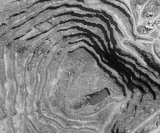
This image is from NASA World Wind taken on the Clementine mission.
I screen captured it from their program simular to Google Earth, and the data set was probably produced between February and April of 1994 for the Naval Research Laboratory.
The step like structures are clearly visible.
This image is from the Lunar Orbiter II, taken 23 November 1966.
Looks like the same image Skeptic posted above.
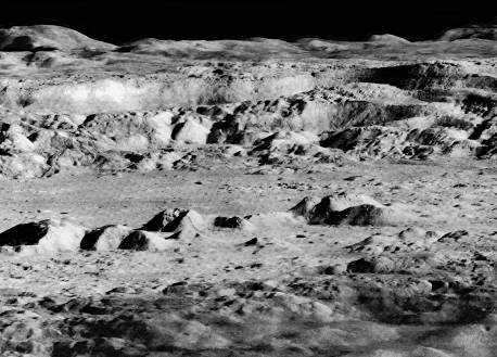
Called by the media the “Picture of the Century,” it is looking in the same direction, to the north, but the telephoto lens has changed the whole atmosphere of thecrater.
Now the frame is filled with a forbidding landscape of plunging cliffs, sweeping escarpments, and tumbling landslides backed by desolate mountain ranges rolling away into the distance. Ringed by rugged 600 metre high cliffs, a jagged mountain ridge thrusts up from the crater floor to a height of 305 metres.
This view must have awed the Apollo astronauts, about to embark on their voyages to the Moon. In fact, this is the crater that was supposed to be the destination of Apollo 20, the last Apollo mission, as a spectacular finale of the Moon landing program. One suggestion was for the astronauts to fly a small spacecraft to the ledges of the surrounding cliffs. It’s a pity it was cancelled – it would have been an exciting mission.
www.honeysucklecreek.net...
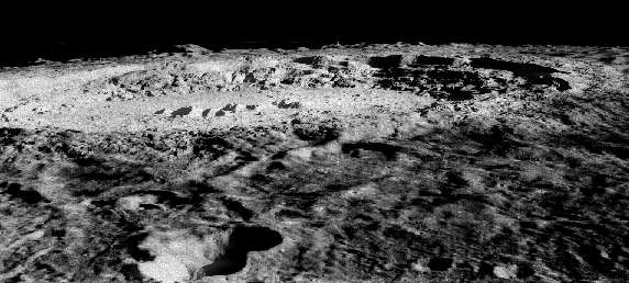
This one's a longer shot from the same mission:
Now back to Earth...........
A diamond mine in Canada:
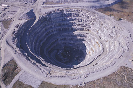
One more pit mine on Earth.
The similarities are striking.
There's a crater in Canada that is currently mined as Skeptic Overlord pointed out...
Crater Mining
If there were a race technologically advanced enough to "be" there...chances are they would have recognized a good opportunity.
Opportunistic little green men
Crater Mining
If there were a race technologically advanced enough to "be" there...chances are they would have recognized a good opportunity.
Opportunistic little green men
Nice job on the mine pics..
If America had the ability to mine on the Moon before we even got there.. where did the technology come from, why are there no bases there? Why have we stopped going? If in 1966 we could mine on the moon, why are we not going to Mars anytime soon?
MR. Lear, could you explain the gravity issue on page 1? thanks.
Originally posted by SkepticOverlord
I can't speak for John Lear if that's who your question is for... but I would think that, if we're looking at a surface strip mine, it's ancient and long abandoned.
i was speaking to whoever
i know you are a skeptic and everything but, may i ask, what is your opinion on this supposed mine???
or is it still too early for you to formulate an opinion???
as for myself, i think it is a mining area (but i am not an expert and i am very new to this thread)...
plus i am an "alien optimist"
If the site is an ancient site . . . perhaps mined by other people before our time in earth, then I guess they are not different from us when it comes
to opportunism and techniques.
Originally posted by they see ALL
i know you are a skeptic and everything
-sigh-
People still misunderstand the "Skeptic" part of my site name.
It means I'm skeptical of what we've been told... not that I'm skeptical of alternative topics.
I think there may be an interesting probability that we are looking at an ancient strip mine site... and not one used by humans.
Originally posted by marg6043
Could the operations be underground?
But back in the 60s did the US had such technology as to make possible to mine in the moon?
Or to build facilities underground.
I can't vouch for USA's capability in mining moon but as far as I'm concerned they had the technology to build underground bases since mid 50's. In 1956 Rand Corporation held a symposium about underground bases and the technology to achieve such goal. And the technology was a borin machine, atomic powered that could bore a tunnel in a hard strata with a rate of 5 miles a day, etc... imagine 10 years later or now days. So the technology existed.
Titanium?
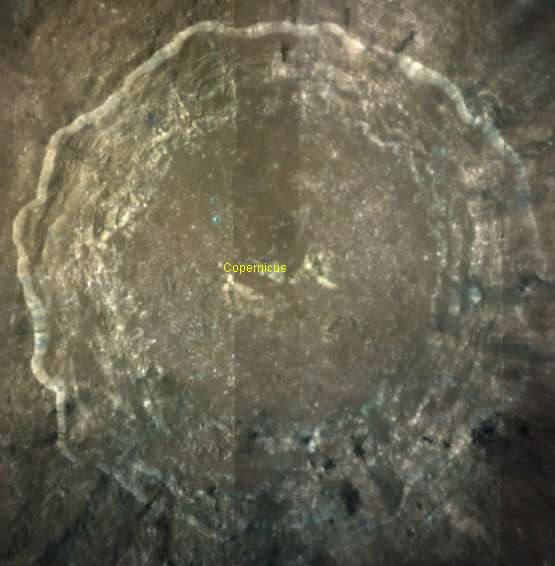
This is a false color image taken by Galileo spacecraft.
the Bluer the area, the more titanium present.
Copernicus is pretty much in the center of the image..
the region doesn't look very blue, but it's covered with an ejecta blanket.
You can sort of see the blue underneath.
A natural Titanium mine?
If I had to mine the moon for titanium, and I've often wanted to do that (j/k).
Maybe thats a good place?
[edit on 19-9-2006 by spacedoubt]
Nice photo Spacedoubt,
Copernicus seems like the bluest spot on the map. Maybe not the biggest, but looks like a darker blue than any other spot on the map. Maybe the mining of titanium is another piece of this puzzle...
I still think there must be some kind of oxygen extraction from the rocks going on there too.
Copernicus seems like the bluest spot on the map. Maybe not the biggest, but looks like a darker blue than any other spot on the map. Maybe the mining of titanium is another piece of this puzzle...
I still think there must be some kind of oxygen extraction from the rocks going on there too.
some of you keep mentioning that they are mining for some rare material but if this is real it could be that they are just mining for building
materials. its easier to mine them there than to haul them all the way from earth.
hehe - good idea.. It actually looks like it could be an old mine..from the time of Atlantis and stuff..
If we take the story all the way out there - then why not?!
If we take the story all the way out there - then why not?!
Who could mine the moon? Maybe the grays were there? What about an ancient human civilization like Atlantis that disappeared?
Mining would be good on the moon, no water, plants, weather etc to deal with. The lighter gravity would make moving mass easier too. Makes sense to mine the moon.
Mining would be good on the moon, no water, plants, weather etc to deal with. The lighter gravity would make moving mass easier too. Makes sense to mine the moon.
Tell you what, if I owned Google, Apple, Microsoft -- i.e. was filthy rich -- my probe would be up on the Moon and on Mars taking hi-res pics of every
square inch, just for sh1ts and giggles.
Larry/Sergey, Steve, Bill -- forget the money you're making, you can't spend it all -- really leave a lasting legacy for the human race. See what's going on, get some video.
Chaz.
[edit on 19-9-2006 by Chaz]
Larry/Sergey, Steve, Bill -- forget the money you're making, you can't spend it all -- really leave a lasting legacy for the human race. See what's going on, get some video.
Chaz.
[edit on 19-9-2006 by Chaz]
new topics
-
Maestro Benedetto
Literature: 8 minutes ago -
Is AI Better Than the Hollywood Elite?
Movies: 16 minutes ago -
Las Vegas UFO Spotting Teen Traumatized by Demon Creature in Backyard
Aliens and UFOs: 3 hours ago -
2024 Pigeon Forge Rod Run - On the Strip (Video made for you)
Automotive Discussion: 4 hours ago -
Gaza Terrorists Attack US Humanitarian Pier During Construction
Middle East Issues: 4 hours ago -
The functionality of boldening and italics is clunky and no post char limit warning?
ATS Freshman's Forum: 6 hours ago -
Meadows, Giuliani Among 11 Indicted in Arizona in Latest 2020 Election Subversion Case
Mainstream News: 6 hours ago -
Massachusetts Drag Queen Leads Young Kids in Free Palestine Chant
Social Issues and Civil Unrest: 6 hours ago -
Weinstein's conviction overturned
Mainstream News: 8 hours ago -
Supreme Court Oral Arguments 4.25.2024 - Are PRESIDENTS IMMUNE From Later Being Prosecuted.
Above Politics: 9 hours ago
top topics
-
Krystalnacht on today's most elite Universities?
Social Issues and Civil Unrest: 9 hours ago, 9 flags -
Supreme Court Oral Arguments 4.25.2024 - Are PRESIDENTS IMMUNE From Later Being Prosecuted.
Above Politics: 9 hours ago, 8 flags -
Weinstein's conviction overturned
Mainstream News: 8 hours ago, 7 flags -
University of Texas Instantly Shuts Down Anti Israel Protests
Education and Media: 12 hours ago, 6 flags -
Massachusetts Drag Queen Leads Young Kids in Free Palestine Chant
Social Issues and Civil Unrest: 6 hours ago, 6 flags -
Gaza Terrorists Attack US Humanitarian Pier During Construction
Middle East Issues: 4 hours ago, 6 flags -
Meadows, Giuliani Among 11 Indicted in Arizona in Latest 2020 Election Subversion Case
Mainstream News: 6 hours ago, 5 flags -
Las Vegas UFO Spotting Teen Traumatized by Demon Creature in Backyard
Aliens and UFOs: 3 hours ago, 3 flags -
2024 Pigeon Forge Rod Run - On the Strip (Video made for you)
Automotive Discussion: 4 hours ago, 2 flags -
Any one suspicious of fever promotions events, major investor Goldman Sachs card only.
The Gray Area: 14 hours ago, 2 flags
active topics
-
University of Texas Instantly Shuts Down Anti Israel Protests
Education and Media • 210 • : DBCowboy -
Is AI Better Than the Hollywood Elite?
Movies • 1 • : 5thHead -
British TV Presenter Refuses To Use Guest's Preferred Pronouns
Education and Media • 164 • : Annee -
VP's Secret Service agent brawls with other agents at Andrews
Mainstream News • 56 • : CarlLaFong -
Maestro Benedetto
Literature • 0 • : BrotherKinsMan -
Massachusetts Drag Queen Leads Young Kids in Free Palestine Chant
Social Issues and Civil Unrest • 11 • : marg6043 -
Electrical tricks for saving money
Education and Media • 7 • : chr0naut -
Definitive 9.11 Pentagon EVIDENCE.
9/11 Conspiracies • 424 • : Zanti Misfit -
Las Vegas UFO Spotting Teen Traumatized by Demon Creature in Backyard
Aliens and UFOs • 8 • : Macenroe82 -
SHORT STORY WRITERS CONTEST -- April 2024 -- TIME -- TIME2024
Short Stories • 23 • : DontTreadOnMe