It looks like you're using an Ad Blocker.
Please white-list or disable AboveTopSecret.com in your ad-blocking tool.
Thank you.
Some features of ATS will be disabled while you continue to use an ad-blocker.

Tropical Storm Ernesto
page: 2share:
not much going on here when it comes to wind. Heavy rains for the past 20-30 minutes now. Little thunder, nothing to get excited over though, I've
seen fiercer afternoon thunderstorms.
I'm relieved, but still wary about the overall effects of the storm, I'm sure with these heavy rains, south floridians with blue roofs or damaged roofs are experiencing problems.
I'm relieved, but still wary about the overall effects of the storm, I'm sure with these heavy rains, south floridians with blue roofs or damaged roofs are experiencing problems.
Originally posted by worldwatcher
I've seen fiercer afternoon thunderstorms.
At 4AM I saw a person from Key West on the news saying the exact same thing. He lives on a boat there.
My area is now confirmed to be pretty much a non-event, the schools will not even close today, with the worst (more rain than wind being the worry) hitting on the overnight this evening. Looks like I don't even have to worry about the bridge closing during work (which would prevent me from getting beachside to back home tonight.
I'll be watching any updates from you WW as your area gets the impact today and will be an obvious gauge for those of us in the north. We have our generators ready for power outages, but no one (even beachside) has bothered boarding up. I work for a property management firm with most commercial properties beachside and they are not bothering to bring out the boards. No school closings in Flagler (just north of Daytona) which confirms they do not expect ot even have to close the bridge over the intracoastal (or they couldn't get the kids home).
I do wonder about that canal out your back. Did that ever overflow it's banks onto your property in 2004?
I do want to add that the buzzing of beetles last night in the woods behind my house was never so loud and sustained. It definately caught my attention, whatever it means. I guess the big question is will there be dead silence today?
[edit on 8/30/2006 by Relentless]
Watch it but don't worry too much about it, just listen to your local officials for advisements. Ernesto has been downgraded to a depression, I
think if it hits the Atlantic, it may get up to Tropical Storm strength again, but I don't think we'll see it being a hurricane again.
We might still get some of the heavier rains later today in Broward, but up to now, the rain has also been non event also. Sustained winds are under 20mph and we're getting gusts in the 20-35 mph range. We've had cold front that brought the same type of wind conditions here before too.
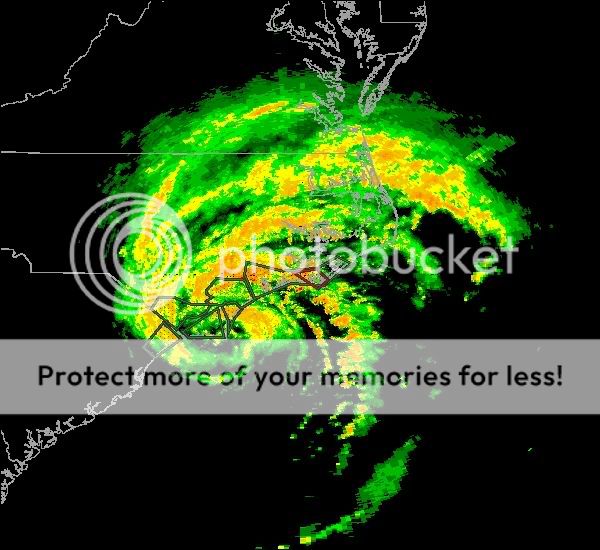
Imo it looks a whole worse on satellite and radar than what is actually being felt on the ground.
Relentless, (knock on wood) I've never had the canal really breach it's banks yet, even with the no name storm that had caused severe flooding in the area back in 98.
[edit on 8-30-2006 by worldwatcher]
We might still get some of the heavier rains later today in Broward, but up to now, the rain has also been non event also. Sustained winds are under 20mph and we're getting gusts in the 20-35 mph range. We've had cold front that brought the same type of wind conditions here before too.
Imo it looks a whole worse on satellite and radar than what is actually being felt on the ground.
Relentless, (knock on wood) I've never had the canal really breach it's banks yet, even with the no name storm that had caused severe flooding in the area back in 98.
[edit on 8-30-2006 by worldwatcher]
Well, I'm very happy to see that it isn't very bad over there, WorldWatcher.
Let's hope that this is the worst storm we get this year and I hope everything continues to go well.
Let's hope that this is the worst storm we get this year and I hope everything continues to go well.
Looks like Ernie is stronger now, than he was coming ashore...go figure.
Hope you all need the rain. Looks like a real soaker.

Hope you all need the rain. Looks like a real soaker.
Ernesto has been one very odd storm. Maintaining it's circulation over it's traverse of Florida as a depression and then regaining strenght as
atropical storm now.
I don't know if anything changed with Ernesto, but imo he was much more impressive on imagery than on the ground over south florida, hope he stays that way for the Carolinas.
[edit on 8-31-2006 by worldwatcher]
Tropical Storm ERNESTO Public Advisory...ERNESTO CONTINUES MOVING NORTHWARD TOWARD THE CAROLINAS...
A TROPICAL STORM WARNING REMAINS IN EFFECT FROM FLAGLER BEACH
FLORIDA TO CAPE LOOKOUT NORTH CAROLINA.
FOR STORM INFORMATION SPECIFIC TO YOUR AREA...INCLUDING POSSIBLE
INLAND WATCHES AND WARNINGS...PLEASE MONITOR PRODUCTS ISSUED
BY YOUR LOCAL WEATHER OFFICE.
AT 800 AM EDT...1200Z...THE CENTER OF TROPICAL STORM ERNESTO WAS
LOCATED NEAR LATITUDE 30.4 NORTH...LONGITUDE 79.9 WEST OR ABOUT 95
MILES...155 KM...EAST OF JACKSONVILLE FLORIDA AND ABOUT 170 MILES...
275 KM...SOUTH OF CHARLESTON SOUTH CAROLINA.
ERNESTO IS MOVING TOWARD THE NORTH NEAR 15 MPH...24 KM/HR...AND A
GRADUAL TURN TOWARD THE NORTH-NORTHEAST AND A FASTER FORWARD SPEED
ARE EXPECTED DURING THE NEXT 24 HOURS. THIS MOTION WILL TAKE THE
CENTER OF ERNESTO FARTHER AWAY FROM THE COAST OF NORTHEAST FLORIDA
TODAY...AND COULD BRING THE CENTER NEAR THE NORTH AND SOUTH CAROLINA
COASTS LATE THIS AFTERNOON OR TONIGHT.
MAXIMUM SUSTAINED WINDS HAVE INCREASED TO NEAR 55 MPH...90 KM/HR...
WITH HIGHER GUSTS. SOME STRENGTHENING IS FORECAST DURING THE NEXT
24 HOURS.
TROPICAL STORM FORCE WINDS EXTEND OUTWARD UP TO 85 MILES...140 KM
MAINLY TO THE SOUTHEAST OF THE CENTER.
LATEST MINIMUM CENTRAL PRESSURE REPORTED BY AN AIR FORCE PLANE WAS
996 MB...29.41 INCHES.
I don't know if anything changed with Ernesto, but imo he was much more impressive on imagery than on the ground over south florida, hope he stays that way for the Carolinas.
[edit on 8-31-2006 by worldwatcher]
10 hours to go before landfall, will Ernie make hurricane status?
NHC/NWS says Ernie will not become a hurricane. Any bets?
Detailed State Weather Info: NWS Forecast Offices
• Charleston, South Carolina
• Wilmington, NC
• Newport/Morehead City, NC
[edit on 31-8-2006 by Regenmacher]

NHC/NWS says Ernie will not become a hurricane. Any bets?
TROPICAL STORM ERNESTO LOCAL STATEMENT
NATIONAL WEATHER SERVICE WILMINGTON NC
1158 AM EDT THU AUG 31 2006
A HURRICANE WATCH HAS BEEN ADDED. AT THIS TIME...ERNESTO IS NOT
FORECAST TO BECOME A HURRICANE. HOWEVER...FURTHER STRENGTHENING
WOULD REQUIRE THE ISSUANCE OF A HURRICANE WARNING.
A TROPICAL STORM WARNING IS IN EFFECT ALONG THE COAST FROM
THE SOUTH SANTEE RIVER IN SOUTH CAROLINA TO SURF CITY NORTH
CAROLINA. TROPICAL STORM CONDITIONS ARE FORECAST TODAY INTO TONIGHT.
A FLOOD WATCH IS IN EFFECT THROUGH MIDNIGHT FOR HEAVY RAIN ACROSS
THE AREA. A WIND ADVISORY IS IN EFFECT FOR INLAND COUNTIES. NWS
Detailed State Weather Info: NWS Forecast Offices
• Charleston, South Carolina
• Wilmington, NC
• Newport/Morehead City, NC
[edit on 31-8-2006 by Regenmacher]
Lastest Recon has winds up to 70 (and the pressure down to 993)....
Looks like it will be a cat 1 before landfall.
[edit on 31-8-2006 by ThatsJustWeird]
Looks like it will be a cat 1 before landfall.
DATA FROM A NOAA P-3 RECONNAISSANCE AIRCRAFT INDICATE THAT MAXIMUM
SUSTAINED WINDS HAVE INCREASED TO NEAR 70 MPH...110 KM/HR...WITH
HIGHER GUSTS. ERNESTO COULD STRENGTHEN A LITTLE MORE AND REACH THE
COAST AS A HURRICANE.
TROPICAL STORM FORCE WINDS EXTEND OUTWARD UP TO 85 MILES...140 KM
MAINLY TO THE NORTH AND EAST OF THE CENTER.
LATEST MINIMUM PRESSURE REPORTED BY A NOAA P-3 RECONNAISSANCE PLANE
WAS IS 993 MB...29.32 INCHES.
[edit on 31-8-2006 by ThatsJustWeird]
Late August? The gulf stream temps should be hot enough to heat it up some. I say yes, he'll hit the coast as a cane.
Hopefully with enough speed to blow thru quickly, not hang about and dump more rain than they can handle. That's what punch Ernesto will be handing out. Hope they're batting down the hatches in Charleston.
What's the upper levels doing inland there? Is there a high nearby to keep it offshore?
Hopefully with enough speed to blow thru quickly, not hang about and dump more rain than they can handle. That's what punch Ernesto will be handing out. Hope they're batting down the hatches in Charleston.
What's the upper levels doing inland there? Is there a high nearby to keep it offshore?

new topics
-
This is our Story
General Entertainment: 2 hours ago -
President BIDEN Vows to Make Americans Pay More Federal Taxes in 2025 - Political Suicide.
2024 Elections: 4 hours ago -
Ode to Artemis
General Chit Chat: 5 hours ago -
Ditching physical money
History: 9 hours ago -
One Flame Throwing Robot Dog for Christmas Please!
Weaponry: 9 hours ago -
Don't take advantage of people just because it seems easy it will backfire
Rant: 9 hours ago -
VirginOfGrand says hello
Introductions: 10 hours ago -
Should Biden Replace Harris With AOC On the 2024 Democrat Ticket?
2024 Elections: 10 hours ago
top topics
-
University student disciplined after saying veganism is wrong and gender fluidity is stupid
Education and Media: 13 hours ago, 12 flags -
Police clash with St George’s Day protesters at central London rally
Social Issues and Civil Unrest: 16 hours ago, 9 flags -
President BIDEN Vows to Make Americans Pay More Federal Taxes in 2025 - Political Suicide.
2024 Elections: 4 hours ago, 9 flags -
TLDR post about ATS and why I love it and hope we all stay together somewhere
General Chit Chat: 17 hours ago, 7 flags -
Should Biden Replace Harris With AOC On the 2024 Democrat Ticket?
2024 Elections: 10 hours ago, 6 flags -
Don't take advantage of people just because it seems easy it will backfire
Rant: 9 hours ago, 4 flags -
One Flame Throwing Robot Dog for Christmas Please!
Weaponry: 9 hours ago, 4 flags -
God lived as a Devil Dog.
Short Stories: 14 hours ago, 3 flags -
Ditching physical money
History: 9 hours ago, 3 flags -
VirginOfGrand says hello
Introductions: 10 hours ago, 2 flags
active topics
-
The Reality of the Laser
Military Projects • 33 • : ADVISOR -
Terrifying Encounters With The Black Eyed Kids
Paranormal Studies • 71 • : FlyersFan -
This is our Story
General Entertainment • 1 • : Encia22 -
whistleblower Captain Bill Uhouse on the Kingman UFO recovery
Aliens and UFOs • 17 • : vance2 -
DerBeobachter - Electric Boogaloo 2
Introductions • 13 • : DerBeobachter2 -
One Flame Throwing Robot Dog for Christmas Please!
Weaponry • 7 • : OzBiker -
University student disciplined after saying veganism is wrong and gender fluidity is stupid
Education and Media • 26 • : DerBeobachter2 -
President BIDEN Vows to Make Americans Pay More Federal Taxes in 2025 - Political Suicide.
2024 Elections • 4 • : 727Sky -
British TV Presenter Refuses To Use Guest's Preferred Pronouns
Education and Media • 128 • : Consvoli -
Tucker Carlson UFOs are piloted by spiritual entities with bases under the ocean and the ground
Aliens and UFOs • 42 • : Jukiodone