It looks like you're using an Ad Blocker.
Please white-list or disable AboveTopSecret.com in your ad-blocking tool.
Thank you.
Some features of ATS will be disabled while you continue to use an ad-blocker.

Interesting man-made landscape in China
page: 1share:
The following link takes you to Google Maps, with a picture of what appears to be a man-made topographical representation of somewhere, complete with
rivers and snow capped mountains.
Link to Google Maps
Mud maps are something the military still uses to this day, but the scale of the project is quite impressive (over a kilometre long by the looks of it).
Any thoughts on where it could be, or what the role of the co-located facility is? There is certainly access control (gates) at various places, so I'm thinking military at least.
Look forward to reading your thoughts!
This image is from the model in your link.
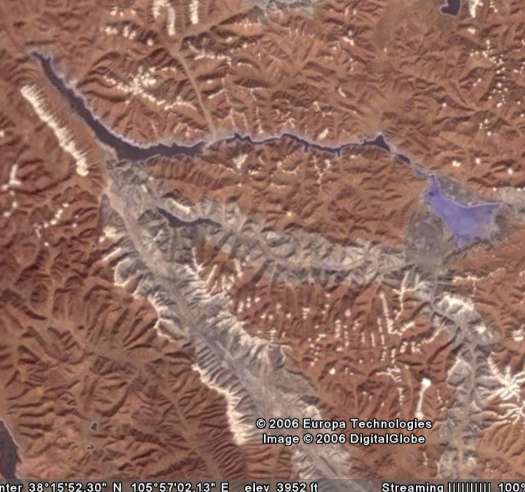
This image is from an area along the border with India.
Google Earth has the borders marked out in red around that area, so they might be fighting over the land.
The detail in that model is amazing, and the thing is huge.
Maybe this is China's version of Google Earth.
EDIT: This will give everyone an idea of the scale of the thing........
[edit on 20/7/2006 by anxietydisorder]
India and China have previously clashed over the border region. It was so long ago that Nehru was Prime Minister. It was never resolved, China moved
back to the previous "line of control" but there was no border negotiation or treaty. However, unlike Kashmir, it was a one-time thing.
China and India recently re-opened the mountain pass in the border region that has been closed ever since the fighting.
It was a traditional trade route between India and China for a couple of thousand years.
China and India recently re-opened the mountain pass in the border region that has been closed ever since the fighting.
It was a traditional trade route between India and China for a couple of thousand years.
The more I look at it, the more I think it's military.
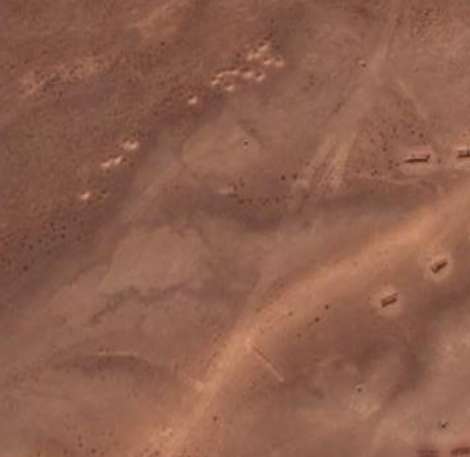
This looks like barracks to me.
If you look at the area at the top north west corner of the recreation it appears to have a bunch of holes in the ground like they've been shooting artillary at the hillside.
When you consider the area that the mock-up covers, it sounds more and more like a training area of some type for the army.
The area that was fought over is part of the mock-up.
This looks like barracks to me.
If you look at the area at the top north west corner of the recreation it appears to have a bunch of holes in the ground like they've been shooting artillary at the hillside.
When you consider the area that the mock-up covers, it sounds more and more like a training area of some type for the army.
Indo-China War of 1962
The Chinese have two major claims on what India deems its own territory. One claim, in the western sector, is on Aksai Chin in the northeastern section of Ladakh District in Jammu and Kashmir. The other claim is in the eastern sector over a region included in the British-designated North-East Frontier Agency, the disputed part of which India renamed Arunachal Pradesh and made a state. In the fight over these areas, the well-trained and well-armed troops of the Chinese People's Liberation Army overpowered the ill-equipped Indian troops, who had not been properly acclimatized to fighting at high altitudes.
Unable to reach political accommodation on disputed territory along the 3,225-kilometer-long Himalayan border, the Chinese attacked India on October 20, 1962. At the time, nine divisions from the eastern and western commands were deployed along the Himalayan border with China. None of these divisions was up to its full troop strength, and all were short of artillery, tanks, equipment, and even adequate articles of clothing.
www.globalsecurity.org...
The area that was fought over is part of the mock-up.
You have voted Willard856 for the Way Above Top Secret award. You have two more votes this month.
You have voted anxietydisorder for the Way Above Top Secret award. You have one more vote left for this month.
Great find Willard, that thing is very detailed and pretty impressive. How did you happen to come across that? Thanks for posting it
anxietydisorder, I can't believe you identified what area that mockup was of this place never ceases to amaze me.
The mockup is basically 1/2 mile across, but how big is that area on the Indian border it's a model of? With that we could try to figure out the scale, and what it's purpose might be. Are they training military officers, pilots etc..?
[edit on 22-7-2006 by warpboost]
I was about to post the same thing..
Props to both of you, for digging this up..
"China's version of google earth" yur killing me!
Unfortunately I am out of WATS's.
Next month, remind me..
Props to both of you, for digging this up..
"China's version of google earth" yur killing me!
Unfortunately I am out of WATS's.
Next month, remind me..
Thanks for the kudos guys, I spent a lot of time tracking this one down.
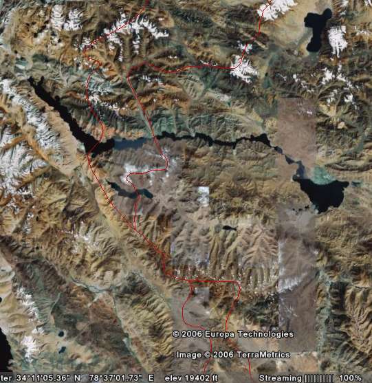
This image from Google Earth covers about the same area covered by the simulation.
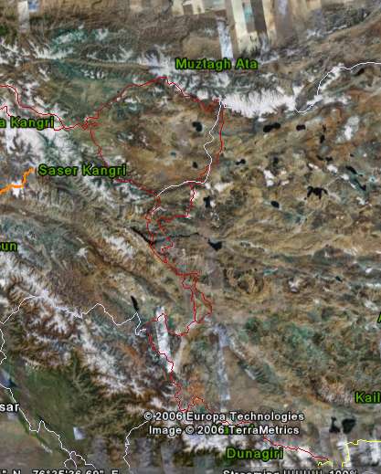
I tried to cut out the entire area that is covered by the mock-up. It's over 400 miles long, and about 300 miles wide in the real world.
This image from Google Earth covers about the same area covered by the simulation.
I tried to cut out the entire area that is covered by the mock-up. It's over 400 miles long, and about 300 miles wide in the real world.
Props to both of you, for digging this up..
Unfortunately I am out of WATS's.
I'm not.
You have voted Willard856 for the Way Above Top Secret award. You have one more vote left for this month.
You have voted anxietydisorder for the Way Above Top Secret award. You have used all of your votes for this month.
My question is; is this a mock-up of the area near where Osama may be, or is that too far north for this?
Edit: Yup, the Wakhan corridor is too far north.
Great finds, none the less, to the both of you.
Wonder how long this life sized recreation has been there?
[edit on 7/22/06 by redmage]
After you posted about Osama I took another look at the area that the mock-up displays.
It is in the general area that the media has said he could be in, but I don't think China has any interest in hunting down an enemy of America.
This has to be something for their own self interest being that the area depicted is an area that is still under dispute by the two countries.
It just blows my mind that they would construct such a large recreation, and in so much detail.
Perhaps it's for military training, or for mapping resources, but anyone could do the same with a cheap home computer.
It all seems very strange.............
Originally posted by anxietydisorder
It just blows my mind that they would construct such a large recreation, and in so much detail.
Perhaps it's for military training, or for mapping resources, but anyone could do the same with a cheap home computer.
I was wondering the same thing? In this age of computers why mess with constructing a 1/2 mile long model?
I wonder what it's used for? Military training? if so what would it be used for? To orient pilots, simulate a battle in the region, train artillary officers? I was thinking maybe they use little scale cannons on it to simulate artillery fire missions
Originally posted by warpboost
Originally posted by anxietydisorder
It just blows my mind that they would construct such a large recreation, and in so much detail.
Perhaps it's for military training, or for mapping resources, but anyone could do the same with a cheap home computer.
I was wondering the same thing? In this age of computers why mess with constructing a 1/2 mile long model?
I wonder what it's used for? Military training? if so what would it be used for? To orient pilots, simulate a battle in the region, train artillary officers? I was thinking maybe they use little scale cannons on it to simulate artillery fire missions
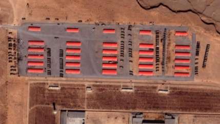
The red buildings have way to many same type of vehicle parked in rows out front of them for it to be civilian, the trucks look like a millitary truck the national guard still has here and there.
many of the best armies in the world use sand tables, they use them because its easier to use and understand and does not break down like computers. it looks like it was there to train the unit in the type of geography it was expected to fight in, an idea that is not new to us or other armies. many operation iracki freedom mobilization stations are as far south as can be because of the heat there and the fact that its really freakin hot over there. basicly the thinking is, if its hot where we are going then we want to train up some where where it is equally hot to get ready for it. same thing here.
I am relieved its not of any where in the us. all though if we look hard enough I suspect we would find one of some where in the US.
Thanks to everyone for your input thus far, it has been an excellent discussion. I'm a little embarrassed with the WATS, a friend of mine sent me the
link, I simply posted it here as I thought some of you would find it interesting, so I in know way scrolled through Google Earth to find it. But I
appreciate the thought nonetheless.
Having worked with computer recreations of fairly severe topographical terrain such as Afghanistan, it is actually quite hard to get a "feel" for the true extent of the real terrain (if you get what I mean by "feel"). However, I've never seen something so detailed before. For someone who is potentially going to be operating in such terrain, a model such as that would give you an excellent ability to determine choke points, line of site, artillery placement, and a swag of other useful military planning pointers. Given the effort that has gone into the model, maybe it is a planning resource for senior military planner? While the building nearby are almost certainly military, there doesn't seem to be the amount of accomodation you would expect from a typical base, which again makes me feel it is more a training college rather than a dedicated base. But I could be wrong!
I'll be handing out some WATS myself shortly, thanks again for your interest!
Will
You have voted anxietydisorder for the Way Above Top Secret award. You have two more votes this month.
Don't be embarassed Willard. Even if you didnt orginally find it, you took the time to share here so you deserve it
I still can't figure out how they would use this landscape? Do they walk on it? fly over it? stand on a moveable tower looking down on it? I mean the thing is pretty big so if you stood next to it or on top of it at ground level it probably wouldn't be all that useful since you wouldnt really be able to even see all of it
[edit on 31-7-2006 by warpboost]
Could you please post the Google Earth coordinates of this please?
It would be interesting to check out. I'd like to look because I recall something about China building what would be the largest dam in the world for power generation. So, I'm curious if this is their odd way of planning, instead of or in addition to computer modelling.
It would be interesting to check out. I'd like to look because I recall something about China building what would be the largest dam in the world for power generation. So, I'm curious if this is their odd way of planning, instead of or in addition to computer modelling.
It's "allegedly" a Tank Training ground according to a Bejing news correspondent who contacted the authorities in Huangyangtan. but they're hardly
gonna tell her it's really a terrain for testing their legions of tiny robotic flying butler warrior monkeys now are they.
www.theage.com.au...
www.theage.com.au...
Space.com is running the story now...........
www.space.com...
Lots of pictures at the link, and the story almost looks like this thread we've made on ATS. But they filed the story on July 31st, and this thread started July 20th.
Do you think Space.com reads ATS ???
Or did they get the story from Google Earth Community, like they said in the story ???
Edit: bbcode
[edit on 1/8/2006 by anxietydisorder]
www.space.com...
It is speculated that this scale model is being used by Chinese military planners. If you want to train pilots to work in a particular area that is off-limits, create a model that allows them to practice.
NASA used exactly the same technique in the 1960's to train the pilots-turned-astronauts who were to land on the moon.
Once the probable landing site in the Sea of Tranquility was selected, NASA geologists went to the volcanic mountain range in Arizona. There, they carefully measured the locations of each crater, and used explosives to create an exact scale model of the landing area.
Lots of pictures at the link, and the story almost looks like this thread we've made on ATS. But they filed the story on July 31st, and this thread started July 20th.
Do you think Space.com reads ATS ???
Or did they get the story from Google Earth Community, like they said in the story ???
Google Earth community members have spotted a strange installation by the remote Chinese village of Huangyangtan. A 800x700 meter scale model of a mountainous landscape has been created right next to a military base.
Edit: bbcode
[edit on 1/8/2006 by anxietydisorder]
Ok so they are training pilots with it, but how do they do that? Do they fly over it, stand in some type of moveable tower, or maybe a basket on a
crane or something? I'm trying to understand how they use the model, or what method is utilized if that makes sense.
Hmm, not sure how much a pilot would get out of it, other than general situational awareness. I'd still put my money on general staff officers using
it as a training tool, like at a war college. "Colonel Chang, where would you place the artillery to best provide support to infantry units in the
initial incursion", or something like that.
Maybe Space.Com does read ATS. Hiya if you do!
Again, thanks for the input all. Wonder if there are other similar terrain models floating around?
Maybe Space.Com does read ATS. Hiya if you do!
Again, thanks for the input all. Wonder if there are other similar terrain models floating around?
new topics
-
USO 10 miles west of caladesi island, Clearwater beach Florida
Aliens and UFOs: 2 hours ago -
Abortions in first 12 weeks should be legalised in Germany, commission says
Medical Issues & Conspiracies: 11 hours ago -
Israel ufo shoot down drones?
Aliens and UFOs: 11 hours ago -
Tesla cutting 14,000 jobs
Global Meltdown: 11 hours ago -
On this Day in History, April 15, 1865, Abraham Lincoln Passed Away.
General Chit Chat: 11 hours ago
top topics
-
Anti-Israel Protesters in CHICAGO Chant 'Death to Israel and 'Death to America'
Social Issues and Civil Unrest: 14 hours ago, 15 flags -
Denver to Defund the Police 8.4 Million To Pay for Illegal Aliens
Social Issues and Civil Unrest: 16 hours ago, 14 flags -
Running Through Idiot Protestors Who Block The Road
Rant: 13 hours ago, 12 flags -
Fossils in Greece Suggest Human Ancestors Evolved in Europe, Not Africa
Origins and Creationism: 16 hours ago, 9 flags -
Report March 2024 - Underwater UFOs display capability that ‘jeopardizes US maritime security,’
Aliens and UFOs: 16 hours ago, 6 flags -
Tesla cutting 14,000 jobs
Global Meltdown: 11 hours ago, 6 flags -
Israel ufo shoot down drones?
Aliens and UFOs: 11 hours ago, 5 flags -
Abortions in first 12 weeks should be legalised in Germany, commission says
Medical Issues & Conspiracies: 11 hours ago, 5 flags -
USO 10 miles west of caladesi island, Clearwater beach Florida
Aliens and UFOs: 2 hours ago, 5 flags -
On this Day in History, April 15, 1865, Abraham Lincoln Passed Away.
General Chit Chat: 11 hours ago, 4 flags
active topics
-
The Reality of the Laser
Military Projects • 25 • : Zaphod58 -
Running Through Idiot Protestors Who Block The Road
Rant • 44 • : ScarletDarkness -
Israel ufo shoot down drones?
Aliens and UFOs • 17 • : Zaphod58 -
Tesla cutting 14,000 jobs
Global Meltdown • 43 • : Vermilion -
USO 10 miles west of caladesi island, Clearwater beach Florida
Aliens and UFOs • 6 • : matafuchs -
-@TH3WH17ERABB17- -Q- ---TIME TO SHOW THE WORLD--- -Part- --44--
Dissecting Disinformation • 471 • : 777Vader -
Woke Leftist dems, hate Your Rights and the Country;
Political Issues • 62 • : ashisnotanidiot -
It has begun... Iran begins attack on Israel, launches tons of drones towards the country
World War Three • 625 • : Justoneman -
Candidate TRUMP Now Has Crazy Judge JUAN MERCHAN After Him - The Stormy Daniels Hush-Money Case.
Political Conspiracies • 187 • : Daughter2v2 -
Fossils in Greece Suggest Human Ancestors Evolved in Europe, Not Africa
Origins and Creationism • 45 • : whereislogic