It looks like you're using an Ad Blocker.
Please white-list or disable AboveTopSecret.com in your ad-blocking tool.
Thank you.
Some features of ATS will be disabled while you continue to use an ad-blocker.

Groom Lake Pre-1955
page: 10
share:
Area 51 as we know it now was founded for classified development of the AQUATONE project (U-2) when Tony LeVier (project pilot), Kelly Johnson
(designer), Richard M. Bissell (project director), and Osmond Ritland (AF liason) selected it as the optimum location for the required test site after
2 days flying round Nevada and surveying possible locations.
Yet even before the U-2 base was built there was an Air Force facility at Groom Lake. Groom Lake was selected as a candidate location when Ritland recalled "a little X-shaped field" in southern Nevada, which was actually on the eastern edge of dry lakebed. This was referred to as Nellis Auxiliary Field No.1 but by the time LeVier, Johnson, Bissell and Ritland flew in to do the survey in early 1955 the old airfield was overgrown and unusable.
So basically my question is what was at Groom Lake before 1955? Was the auxiliary airfield there for support of a facility? Was it a bombing target like so many you can see at Nellis?
Also I'm assuming that this airfield was unpaved but I'm suprised that there is absolutely no sign of it anymore on Google Earth. Does anyone know where it was?
My final question regards the story that Groom Lake was Kelly Johnsons second choice as it was further from Burbank than he wanted and it was downwind from the nulcear test site, a concern which came back to haunt Area 51. Johnsons first choice was dubbed Site I and Groom was Site II. My last question is, where was Site I?
Thanks Guys
Most WWII Army Air Fields had auxiliary strips. The Helendale and Grey Buttel RCS facilities were built on two of Victorville AAF's auxiliary fields.
Nellis Auxiliary Field No. 1 was located just off the southeast corner of Groom Lake and is still visible in aerial and satellite imagery. During WWII, the Groom Lake area was part of the gunnery ranges. The Lockheed guys had to clean up a lot of debris from this activity when they were preparing the U-2 test site.
According to Kelly Johnson's personal log, groom was the second choice. It would have been less expensive to built a facility at "Site I." Unfortunately, he didn't give the actual name of Site I in his diary. Since he was looking at dry lakebeds as potential test sites, I think it's safe to assume Site I was another dry lake. It was rejected because it was not as remote as Groom. I have often wondered if it might be Mud Lake, a near-circular playa with nearly five miles of "runway" in any direction. Mud lake is close to Tonopah and Goldfield and would have been somewhat less secure than Groom.
Thanks for the info shadowhawk. What is a gunnery range? Is it similar to a bombing range? I still dont really understand why there would be a runway
in the middle of no where!
Come on guys ... does no one else know anything about Groom Lake before '55?
Come on guys ... does no one else know anything about Groom Lake before '55?
A gunnery range is used for aircraft (In this case) practicing firing thier guns. From my studies of the area there were alot of spent casing around
when Paradise Ranch was discovered. If you are diligent enuf you can find pictures of Groom lake even before this when it was a mining area.
Ok since you mentioned photos pre-1955 I did a little bit of digging (infact a very little bit ... it was the first item on a search for "groom lake
before 1955"). I found this page on Desert Secrets, which has some old photos of Groom
Lake, some during atomic bomb tests and one taken from Groom Mines. I think the problem with these old photos is that loads are probably unknown
because the owner doesnt realise the importance of the image he possesses.
Anyway, on the website there is a large USGS sattelite image of the Groom Lake area taken on 9th October 1952. Check it out here. From this image I identified one area which I thought could possibly be the site of the dirt runway described in my openning post. I've highlighted the area in this image:
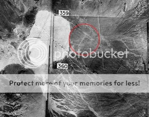
When zoomed you can compare the 1952 image to the 2002 satelite image taken from Google Earth.
This leads me to the conclusion that the area in the image below, contains the remains of "Nellis Auxiliary Field No. 1".

It can be seen that there are two strips of ground which appear outlined and different from surrounding dirt forming an X (or maybe a T). At the crossover point there is a large white area which I cant work out what it is, does anyone know?
So what do you guys think? Do we agree that this is probably the little X airstrip that Ritland remembered?
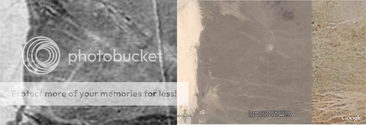
Anyway, on the website there is a large USGS sattelite image of the Groom Lake area taken on 9th October 1952. Check it out here. From this image I identified one area which I thought could possibly be the site of the dirt runway described in my openning post. I've highlighted the area in this image:
When zoomed you can compare the 1952 image to the 2002 satelite image taken from Google Earth.
This leads me to the conclusion that the area in the image below, contains the remains of "Nellis Auxiliary Field No. 1".
It can be seen that there are two strips of ground which appear outlined and different from surrounding dirt forming an X (or maybe a T). At the crossover point there is a large white area which I cant work out what it is, does anyone know?
So what do you guys think? Do we agree that this is probably the little X airstrip that Ritland remembered?
new topics
-
We need less laws in the UK not more
General Chit Chat: 29 minutes ago -
The Baloney aka BS Detection Kit
Social Issues and Civil Unrest: 5 hours ago -
Suspected Iranian agent working for Pentagon while U.S. coordinated defense of Israel
US Political Madness: 5 hours ago -
How does my computer know
Education and Media: 8 hours ago
top topics
-
Suspected Iranian agent working for Pentagon while U.S. coordinated defense of Israel
US Political Madness: 5 hours ago, 12 flags -
USO 10 miles west of caladesi island, Clearwater beach Florida
Aliens and UFOs: 13 hours ago, 9 flags -
The Baloney aka BS Detection Kit
Social Issues and Civil Unrest: 5 hours ago, 3 flags -
How does my computer know
Education and Media: 8 hours ago, 2 flags -
We need less laws in the UK not more
General Chit Chat: 29 minutes ago, 0 flags
0