It looks like you're using an Ad Blocker.
Please white-list or disable AboveTopSecret.com in your ad-blocking tool.
Thank you.
Some features of ATS will be disabled while you continue to use an ad-blocker.

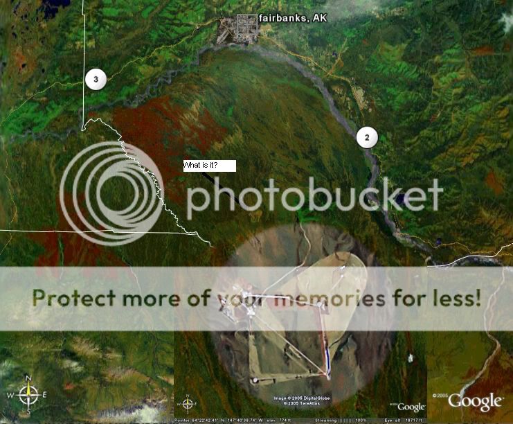
Fairbanks, Alaska?
page: 1share:
Hey all, anybody know what this thing is?
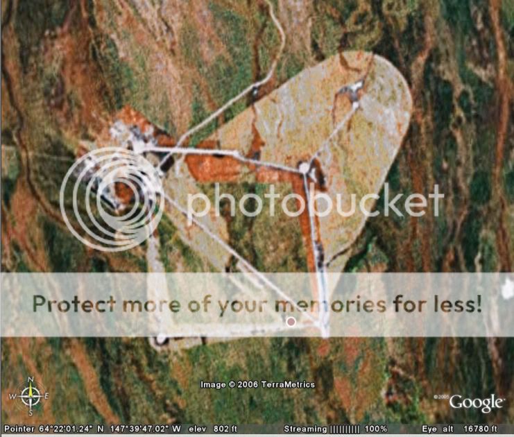
Here's a closer look:
I've read there's supposedly a rex84 concentration camp for 2 million sheeple around Fairbanks, is this it? If not, what is this facility?
Here's a closer look:
I've read there's supposedly a rex84 concentration camp for 2 million sheeple around Fairbanks, is this it? If not, what is this facility?
Just out of curiousity what are Sheeple ? Looks like some sort of camp or something.
[edit on 21-5-2006 by Liamoville]
[edit on 21-5-2006 by Liamoville]
Sheeple = people herded like sheep. Whatever it is, it's big. Does the pipeline run through here? Maybe it's a pump station. Maybe HAARP is
a front and this is the REAL program?
The only info I could find was it's name:
Blair Lake Air Force Range
Blair Lake Air Force Range
Radar/surveillance installation, I'd wager. On or about Blair Lakes Air Force Range
Terraserver has better detail. (Or MS Jive I mean Live Local)
EDIT:
Bombing range, supposedly, although theere seems to be a distinct lack of bomb craters.
[edit on 21-5-2006 by rand]
Terraserver has better detail. (Or MS Jive I mean Live Local)
EDIT:
FAA Notice (Federal Register: June 15, 2005 (Volume 70, Number 114))
R-2211 Blair Lakes, AK [Amended]
Boundaries. Beginning at lat. 64[deg]29'58'' N., long.
147[deg]44'09'' W.; to lat. 64[deg]19'58'' N., long. 147[deg]19'09''
W.; to lat. 64[deg]13'28'' N., long. 147[deg]32'08'' W.; to lat.
64[deg]22'28'' N., long. 147[deg]58'09'' W.; to the point of beginning.
Time of designation. 0800 to 1800, local Monday through Friday,
other times by NOTAM.
Designated altitude. Surface to FL310.
Controlling agency. FAA, Fairbanks Approach Control.
Using agency. U.S. Air Force, 354th Fighter Wing, Eielson AFB, AK.
Bombing range, supposedly, although theere seems to be a distinct lack of bomb craters.
[edit on 21-5-2006 by rand]
Rand - Kudos on the images you found on Terraserver, they are much clearer than the original pics.
So far, all I've been able to find is that the Blair Lakes Air Force Range is one of three ranges used for the Red Flag - Alaska exercise. Red Flag - Alaska is very much like it's more well known counterpart Red Flag - Nellis, exept that it takes place in a colder environment and covers more area.
Red Flag - Alaska
I still don't know what the lines and circles are, maybe the circles are some sort of antenna array?
Originally posted by rand
Bombing range, supposedly, although theere seems to be a distinct lack of bomb craters.
[edit on 21-5-2006 by rand]
this is because a lot of bombing exercises -- esp overland use inert training munitions .
these obviously dont leave much of a crater
Hmmmm this is strange. The same day that i placemark this on Google Earth. All of 'My Places' have been some how deleted Grr that's annoying.
I'm just curious of the fact how long ive had Google Earth and loads and loads of Placemarks, then the first day i add this facility. All of them are deleted.
I'm just curious of the fact how long ive had Google Earth and loads and loads of Placemarks, then the first day i add this facility. All of them are deleted.
looks like an elctroniclly scored bombing range to me based on the land structures, there are a few of these in coastal NC.
Originally posted by ben94gt
looks like an elctroniclly scored bombing range to me based on the land structures, there are a few of these in coastal NC.
Could you name a base with a similar system so that I could check it out?
could be some more missile silos the government is placing. i know someone
on the inside who dose some work for this kind of stuff and thy just placed about 25 more silos in alaska alone.. mostly around the fairbanks and south west islands
of alaska
it could also be a concentration camp i know thy have 2 up there
also
[edit on 5/27/06 by shadowstriker]
on the inside who dose some work for this kind of stuff and thy just placed about 25 more silos in alaska alone.. mostly around the fairbanks and south west islands
of alaska
it could also be a concentration camp i know thy have 2 up there
also
[edit on 5/27/06 by shadowstriker]
I couldn't find exactly where it's at using google maps. Whatever it is it's probably military or something for the oil companies there's not too
much out there. except a few villages and military and oil companies.
EDIT
Found it it looks like it's a pretty far from Eielson air force base so it's probably theirs. And it's far away from fairbanks. I doubt it's a camp as it's dark and very cold in the winter (fairbanks)
[edit on 12-6-2007 by sandman441]
EDIT
Found it it looks like it's a pretty far from Eielson air force base so it's probably theirs. And it's far away from fairbanks. I doubt it's a camp as it's dark and very cold in the winter (fairbanks)
[edit on 12-6-2007 by sandman441]
hi there,
it is part of the usa`s missile defence shield, i will try to find the mil site i found the info on, i remeber i was researching radar instalations at the time.
snoopyuk
it is part of the usa`s missile defence shield, i will try to find the mil site i found the info on, i remeber i was researching radar instalations at the time.
snoopyuk
Im at Eielson which is near fairbanks.
It is not a concentration camp. LOL
It is just a bombing range.
It is not a concentration camp. LOL
It is just a bombing range.
Oh, and where are the concentration camps on Alaska? Im curious, since I live here
I will say this about Alaska...there is a saying....
"you are either here in Alaska for the military or the pipe line....or you are in hiding"
[edit on 1-10-2007 by greeneyedleo]
I will say this about Alaska...there is a saying....
"you are either here in Alaska for the military or the pipe line....or you are in hiding"
[edit on 1-10-2007 by greeneyedleo]
Antenna Farm, circular direction finding antenna's, HF surface wave radar
new topics
-
Russia Flooding
Other Current Events: 19 minutes ago -
MULTIPLE SKYMASTER MESSAGES GOING OUT
World War Three: 48 minutes ago -
Two Serious Crimes Committed by President JOE BIDEN that are Easy to Impeach Him For.
US Political Madness: 1 hours ago -
911 emergency lines are DOWN across multiple states
Breaking Alternative News: 1 hours ago -
Former NYT Reporter Attacks Scientists For Misleading Him Over COVID Lab-Leak Theory
Education and Media: 3 hours ago -
Why did Phizer team with nanobot maker
Medical Issues & Conspiracies: 4 hours ago -
Pro Hamas protesters at Columbia claim hit with chemical spray
World War Three: 4 hours ago -
Elites disapearing
Political Conspiracies: 6 hours ago -
A Personal Cigar UFO/UAP Video footage I have held onto and will release it here and now.
Aliens and UFOs: 6 hours ago -
Go Woke, Go Broke--Forbes Confirms Disney Has Lost Money On Star Wars
Movies: 8 hours ago
top topics
-
British TV Presenter Refuses To Use Guest's Preferred Pronouns
Education and Media: 14 hours ago, 17 flags -
Go Woke, Go Broke--Forbes Confirms Disney Has Lost Money On Star Wars
Movies: 8 hours ago, 12 flags -
Pro Hamas protesters at Columbia claim hit with chemical spray
World War Three: 4 hours ago, 11 flags -
Trump To Hold Dinner with President of Poland At Trump Tower Tonight
2024 Elections: 17 hours ago, 8 flags -
Elites disapearing
Political Conspiracies: 6 hours ago, 7 flags -
Freddie Mercury
Paranormal Studies: 8 hours ago, 7 flags -
Tucker Carlson interviews Christian pastor from Bethlehem.
Middle East Issues: 16 hours ago, 7 flags -
A Personal Cigar UFO/UAP Video footage I have held onto and will release it here and now.
Aliens and UFOs: 6 hours ago, 5 flags -
Nirvana - Immigrant Song
Music: 13 hours ago, 4 flags -
Two Serious Crimes Committed by President JOE BIDEN that are Easy to Impeach Him For.
US Political Madness: 1 hours ago, 3 flags
active topics
-
Two Serious Crimes Committed by President JOE BIDEN that are Easy to Impeach Him For.
US Political Madness • 6 • : charlest2 -
MULTIPLE SKYMASTER MESSAGES GOING OUT
World War Three • 5 • : Nekbet2024 -
Russia Flooding
Other Current Events • 0 • : Kenzo -
-@TH3WH17ERABB17- -Q- ---TIME TO SHOW THE WORLD--- -Part- --44--
Dissecting Disinformation • 516 • : cherokeetroy -
AARO/Dr Kirkpatrick-Caught Lying in UAP report.
Aliens and UFOs • 24 • : Ophiuchus1 -
Go Woke, Go Broke--Forbes Confirms Disney Has Lost Money On Star Wars
Movies • 15 • : 5thHead -
911 emergency lines are DOWN across multiple states
Breaking Alternative News • 0 • : TheGoondockSaint -
Pro Hamas protesters at Columbia claim hit with chemical spray
World War Three • 10 • : KrustyKrab -
Elites disapearing
Political Conspiracies • 16 • : annonentity -
Israel ufo shoot down drones?
Aliens and UFOs • 25 • : introufo2