It looks like you're using an Ad Blocker.
Please white-list or disable AboveTopSecret.com in your ad-blocking tool.
Thank you.
Some features of ATS will be disabled while you continue to use an ad-blocker.

Google earth strange findings post your finds
page: 15share:
This is an image I just took from Google Earth, located in the middle of the Brazilian jungle. Any ideas as to what the circular objects are? Or what
the thin roadway would be for? It is too narrow to be an airstrip.

reply to post by allenidaho
looks reflective, probably water, like a river that isn't covered by trees.
looks reflective, probably water, like a river that isn't covered by trees.
Is there anything that is regularly watered around DIA ? Those two pits look like nothing more than permanent run of the mill irrigation ponds to me.
If there is a sewage treatment facility in the area they could also be settlement ponds.
Obviously sewage plants are usually easy to identify but there seems to be lots of room around there so something more remote or even built for future expansion etc wouldn't surprise me. Wouldn't doubt if they were the result of having leftover building material from a large pour. Seems like you can never have enough irrigation on large projects like DIA.
Obviously sewage plants are usually easy to identify but there seems to be lots of room around there so something more remote or even built for future expansion etc wouldn't surprise me. Wouldn't doubt if they were the result of having leftover building material from a large pour. Seems like you can never have enough irrigation on large projects like DIA.
edit on 22-8-2011 by Candycab because: add another thought
well, i'll tell you but keep it SECRET okay? i was researching "area 51" on google earth and i saw a person in this old building because google
earth isn't live (dates a few months back), i thought it was a glitch.... kind of weird huh? not amazing or cool...but a bit frightning. have you
found anything like that?
Use this in google maps, not google earth :
-47.238482,-127.313011
What can it be ? (it's near the Nemo point, and near where the bloop sound was heard in 1997)
-47.238482,-127.313011
What can it be ? (it's near the Nemo point, and near where the bloop sound was heard in 1997)
My latest thread may be found for now in the "2012" Forum until moved to this forum.
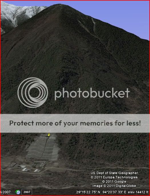
Doomsday Bunker/Facility Hidden In The Mountains Of Tibet?
www.abovetopsecret.com...
Sample photo from the thread:
29°17'0.33"N, 94°20'58.54"E
Doomsday Bunker/Facility Hidden In The Mountains Of Tibet?
www.abovetopsecret.com...
Sample photo from the thread:
29°17'0.33"N, 94°20'58.54"E
Probably not a bunker. Otherwise, they most likely wouldn't have reinforced the slope with concrete. Also, they wouldn't have a large diameter pipe
coming down from the facility to those outbuildings.
It almost looks like some sort of underground water reservoir or possibly a mine.
It almost looks like some sort of underground water reservoir or possibly a mine.
On Google Earth Go directly to the Eiffel Tower and go across the river to this building and if you see it you might think it is funny.
Originally posted by Kjack93
On Google Earth Go directly to the Eiffel Tower and go across the river to this building and if you see it you might think it is funny.
Umm? What are you smoking?
cloud over area 51 and theres a green/black lake, i dont have a clue what it is
reply to post by firmbeliever
Try putting Glastonbury, England, into the search box on Google Earth. If you look carefully you will find not only crop circles but the imprints left after old crop circles have been harvested.
Try putting Glastonbury, England, into the search box on Google Earth. If you look carefully you will find not only crop circles but the imprints left after old crop circles have been harvested.
its to the back of the facility and another few to the left of groom lake
I really want to know what this facility is inside shadow mountain PRESERVE. It can only be seen if you physically hike the mountain.
maps.google.com... l1l0l0l0l0l0l0l0ll0l0&bav=on.2,or.r_gc.r_pw.,cf.osb&biw=1440&bih=807&um=1&ie=UTF-8&sa=N&tab=wl
coordinates 33.614253,-112.029589
maps.google.com... l1l0l0l0l0l0l0l0ll0l0&bav=on.2,or.r_gc.r_pw.,cf.osb&biw=1440&bih=807&um=1&ie=UTF-8&sa=N&tab=wl
coordinates 33.614253,-112.029589
reply to post by JohnDoe11
Reminds me alot of an archeological site... they will sometimes build a structure over a large or important site to protect it from the elements (sandstorms in this case...). I know that there are a large number of archeological sites w/in the city of Phoenix itself...maybe this is one of them.
BTW, heres a photo...someone said they thought it was a wastewater treatment plant....I don't think so, doesn't look like one. The fencing around it is more construction site type fencing, and there is no real infrastructure.
Image Source
edit on 4-1-2012 by JJRichey because: add photo
The other day i discovered over 40 intreasting images from the grand canyon on google earth.I discovered ancient ruins,many strange and secret
tunnels,caves even a crashed ufo.The strangest thing was the giant human skull about one metre wide.That skull was jammed into a deep cravas.No
wounder nobody had found it before.
The tunnels looked intreasting.Most of them looked like doors in the cliff face.One door was lite up like a shop window display or atm machine.Found a couple of what looked like gold deposits and some rock carvings.Thats was only half of the grand canyon i searched.As a new member i cannot post photos of all theses at this time but the locations to these intreasting images have been posted elsewhere on the net.
The tunnels looked intreasting.Most of them looked like doors in the cliff face.One door was lite up like a shop window display or atm machine.Found a couple of what looked like gold deposits and some rock carvings.Thats was only half of the grand canyon i searched.As a new member i cannot post photos of all theses at this time but the locations to these intreasting images have been posted elsewhere on the net.
I will use this for Google Maps as well but you tell what it looks like in Google Earth:
Norio Hayakawa who's held some of the Dulce conferences has this youtube video where he shows something that looks like a door or gate, the coordinates he gives (also on his youtube video description):
maps.google.com...
Norio Hayakawa who's held some of the Dulce conferences has this youtube video where he shows something that looks like a door or gate, the coordinates he gives (also on his youtube video description):
maps.google.com...
I don't have the pictures with me, but at the area 51 Google earth location, (yes, i am able to find it.) there are regular clouds, and then there is
huge "blur" cloud that blocks out what may be some of the base. Same thing around the mayan ruins. What do you think about this?
new topics
-
God's Righteousness is Greater than Our Wrath
Religion, Faith, And Theology: 2 hours ago -
Electrical tricks for saving money
Education and Media: 5 hours ago -
VP's Secret Service agent brawls with other agents at Andrews
Mainstream News: 6 hours ago -
Sunak spinning the sickness figures
Other Current Events: 7 hours ago -
Nearly 70% Of Americans Want Talks To End War In Ukraine
Political Issues: 7 hours ago -
Late Night with the Devil - a really good unusual modern horror film.
Movies: 9 hours ago -
Cats Used as Live Bait to Train Ferocious Pitbulls in Illegal NYC Dogfighting
Social Issues and Civil Unrest: 10 hours ago
top topics
-
VP's Secret Service agent brawls with other agents at Andrews
Mainstream News: 6 hours ago, 9 flags -
Florida man's trip overseas ends in shock over $143,000 T-Mobile phone bill
Social Issues and Civil Unrest: 17 hours ago, 8 flags -
Cats Used as Live Bait to Train Ferocious Pitbulls in Illegal NYC Dogfighting
Social Issues and Civil Unrest: 10 hours ago, 8 flags -
Electrical tricks for saving money
Education and Media: 5 hours ago, 4 flags -
Bobiverse
Fantasy & Science Fiction: 17 hours ago, 3 flags -
HORRIBLE !! Russian Soldier Drinking Own Urine To Survive In Battle
World War Three: 14 hours ago, 3 flags -
Nearly 70% Of Americans Want Talks To End War In Ukraine
Political Issues: 7 hours ago, 3 flags -
Sunak spinning the sickness figures
Other Current Events: 7 hours ago, 3 flags -
Late Night with the Devil - a really good unusual modern horror film.
Movies: 9 hours ago, 2 flags -
The Good News According to Jesus - Episode 1
Religion, Faith, And Theology: 12 hours ago, 1 flags
active topics
-
Nearly 70% Of Americans Want Talks To End War In Ukraine
Political Issues • 12 • : Asher47 -
VP's Secret Service agent brawls with other agents at Andrews
Mainstream News • 39 • : Asher47 -
Electrical tricks for saving money
Education and Media • 4 • : Lumenari -
Cats Used as Live Bait to Train Ferocious Pitbulls in Illegal NYC Dogfighting
Social Issues and Civil Unrest • 19 • : WeMustCare -
New whistleblower Jason Sands speaks on Twitter Spaces last night.
Aliens and UFOs • 54 • : Ophiuchus1 -
DONALD J. TRUMP - 2024 Candidate for President - His Communications to Americans and the World.
2024 Elections • 514 • : WeMustCare -
The Acronym Game .. Pt.3
General Chit Chat • 7744 • : bally001 -
Truth Social goes public, be careful not to lose your money
Mainstream News • 128 • : Astyanax -
Sunak spinning the sickness figures
Other Current Events • 5 • : glen200376 -
SETI chief says US has no evidence for alien technology. 'And we never have'
Aliens and UFOs • 44 • : MikeDeGrasseTyson