It looks like you're using an Ad Blocker.
Please white-list or disable AboveTopSecret.com in your ad-blocking tool.
Thank you.
Some features of ATS will be disabled while you continue to use an ad-blocker.

Google earth strange findings post your finds
page: 10share:
reply to post by Anonymous ATS
Sorry, I posted this before I joined. I copy and pasted the image thinking it would work, but apparently it didn't.
Sorry, I posted this before I joined. I copy and pasted the image thinking it would work, but apparently it didn't.
Found a couple of strange objects on google earth with what look like contrails stretching out behind them at lake issyk tul in Kyrgyzstan which is
apparently a Russian submarine test area (600+metres deep). The 1st is at 42°29'19.99"N 76°45'50.42"E and an almost identical object is nearby
at 42°11'38.46"N 77°35'40.62"E. There appears to be a double image of each as there is a second "reflection" below each object and slightly
offset from it.
Any ideas what they may be ?.
Any ideas what they may be ?.
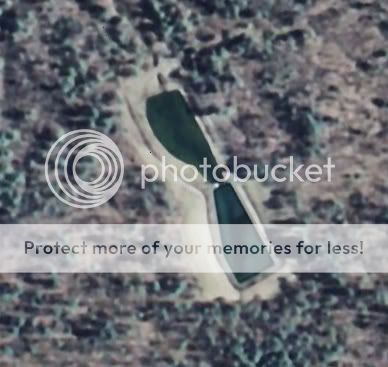
I found something strange at 36 08' 57.52"N -117 52'02.24"W
i don;t understand what it is and may take a drive out there when the weather gets warmer.
i don;t understand what it is and may take a drive out there when the weather gets warmer.
reply to post by Flaminghedgehog
Hi. Look forward to me when I make my own account here, fprrtp6. You know that line that "shoots" off of it? wll, its exactly paralell with the onther line, which appears to e a negative. It may be a ballistic testing facility because there is something similar but under land here where I live in the USA. It might even just be a barge or something, or not actually there at all, like a sattelite disfunction. Take care now!
fprrtp6
This one made me think of a cheesy ZZ Top video, lol. Its directly northeast of Fort Drum NY. Ya can't miss it. Don't know what it is, but it stuck
out like a sore thumb.
LAT: 44° 5'19.52"N
LON: 75°41'23.72"W
LAT: 44° 5'19.52"N
LON: 75°41'23.72"W
reply to post by sevenkev
It seems like a target for missle or bomb practice. See all those little dots around the center? It looks like a target practice to me. And a rather precise for if for a missle (earth to earth)
It seems like a target for missle or bomb practice. See all those little dots around the center? It looks like a target practice to me. And a rather precise for if for a missle (earth to earth)
Moving Lights
If you take a screen shot and enlarge it you can see greenish disk like things under the lights.
i557.photobucket.com...
http://
maps.google.com/maps?f=q&hl=en&geocode=&q=Pine+Gap+Alice+Springs+australia&ie=UTF8&t=h&om=0&ll=-23.835562,134.08159&spn=0.004141,0.007231&z=17
Volcano with Stars in it?
No idea if it is a lake in a volcano reflecting stars or just gas. if you ask my 15 year old she says it's a stargate. I just think its so cool.
i557.photobucket.com...
http://
maps.google.com/maps?f=q&source=s_q&hl=en&geocode=&q=17%C2%B052'2.09%22N+21%C2%B026'47.26%22E&sll=39.893802,-104.684429&sspn=0.034309,0.054932&ie=UT F8&ll=12.963534,24.275601&spn=0.010895,0.013733&t=h&z=16
Grrr links wont show up
[edit on 31-1-2009 by bluecuddle]
This is my first post, hope I am doing this correctly. Strange findings on Google Earth, then this would have to rank right up there with some of the
strangest. This is one image from google earth, I have 200 saved. To me, this looks like a a growth, a vine of some giant proportion that is all
over the nevada desert. There are many tire tracks and vehicles present as well in these images.
Dennis
Well, apparantly I can't upload an image from my desktop. Not sure what to do?
Dennis
Well, apparantly I can't upload an image from my desktop. Not sure what to do?
reply to post by xepicx
Actually the test nuclear weapons there but explode them underground so that they are a contained blast. Hence the hill shapes.
Actually the test nuclear weapons there but explode them underground so that they are a contained blast. Hence the hill shapes.
Check out 28*26'25'' N 7*30'42''E . Some villa with trees and swimming pool. In a desert. And with a surrounding of some factories.
I find that cool
I find that cool
Found this weird white square near area 51
not sure if its been posted, havent looked at everything on here yet
lat - 37°28'42.95"N
long - 115°49'13.15"W
Dunno if its a computer glitch or something
or something soeone's trying to hide. Take a look,
if you cant see it straight up try zooming in a little bit.....
not sure if its been posted, havent looked at everything on here yet
lat - 37°28'42.95"N
long - 115°49'13.15"W
Dunno if its a computer glitch or something
or something soeone's trying to hide. Take a look,
if you cant see it straight up try zooming in a little bit.....
reply to post by MadDogtheHunter
Yea, this is the Officers Golf Club putting green for Fort Drum, N.Y.
Yea, this is the Officers Golf Club putting green for Fort Drum, N.Y.
reply to post by dk2852
I checked and I it came up with Invalid Search. This is the most ridiculous rubbish I have ever heard.
I checked and I it came up with Invalid Search. This is the most ridiculous rubbish I have ever heard.
reply to post by rand
It starts to show me a page with airplanes. But then it switches pages to one of a field and roads.
It starts to show me a page with airplanes. But then it switches pages to one of a field and roads.
How about this one?
Now we know where the Bat Hanger is:
26-21-17 N
127-45-56 E
[atsimg]http://files.abovetopsecret.com/images/member/ee1255630c4a.jpg[/atsimg]
[edit on 3/24/2009 by darkbluesky]
[edit on 3/24/2009 by darkbluesky]
Now we know where the Bat Hanger is:
26-21-17 N
127-45-56 E
[atsimg]http://files.abovetopsecret.com/images/member/ee1255630c4a.jpg[/atsimg]
[edit on 3/24/2009 by darkbluesky]
[edit on 3/24/2009 by darkbluesky]
Near Clayton NM. It looks like snow in some grooves, but if you look at the historical information and the date, it never goes away. The current
image say July 2005.
36°32'37.76"N
103°30'20.29"W
36°32'37.76"N
103°30'20.29"W
new topics
-
University of Texas Instantly Shuts Down Anti Israel Protests
Education and Media: 1 minutes ago -
Any one suspicious of fever promotions events, major investor Goldman Sachs card only.
The Gray Area: 2 hours ago -
God's Righteousness is Greater than Our Wrath
Religion, Faith, And Theology: 6 hours ago -
Electrical tricks for saving money
Education and Media: 9 hours ago -
VP's Secret Service agent brawls with other agents at Andrews
Mainstream News: 11 hours ago -
Sunak spinning the sickness figures
Other Current Events: 11 hours ago -
Nearly 70% Of Americans Want Talks To End War In Ukraine
Political Issues: 11 hours ago
top topics
-
VP's Secret Service agent brawls with other agents at Andrews
Mainstream News: 11 hours ago, 9 flags -
Cats Used as Live Bait to Train Ferocious Pitbulls in Illegal NYC Dogfighting
Social Issues and Civil Unrest: 15 hours ago, 8 flags -
Electrical tricks for saving money
Education and Media: 9 hours ago, 4 flags -
Nearly 70% Of Americans Want Talks To End War In Ukraine
Political Issues: 11 hours ago, 3 flags -
Sunak spinning the sickness figures
Other Current Events: 11 hours ago, 3 flags -
Late Night with the Devil - a really good unusual modern horror film.
Movies: 13 hours ago, 2 flags -
Any one suspicious of fever promotions events, major investor Goldman Sachs card only.
The Gray Area: 2 hours ago, 2 flags -
The Good News According to Jesus - Episode 1
Religion, Faith, And Theology: 17 hours ago, 1 flags -
God's Righteousness is Greater than Our Wrath
Religion, Faith, And Theology: 6 hours ago, 0 flags -
University of Texas Instantly Shuts Down Anti Israel Protests
Education and Media: 1 minutes ago, 0 flags
active topics
-
University of Texas Instantly Shuts Down Anti Israel Protests
Education and Media • 0 • : FlyersFan -
God's Righteousness is Greater than Our Wrath
Religion, Faith, And Theology • 18 • : andy06shake -
Nearly 70% Of Americans Want Talks To End War In Ukraine
Political Issues • 23 • : andy06shake -
Sunak spinning the sickness figures
Other Current Events • 9 • : Ohanka -
The Acronym Game .. Pt.3
General Chit Chat • 7748 • : bally001 -
HORRIBLE !! Russian Soldier Drinking Own Urine To Survive In Battle
World War Three • 37 • : FlyersFan -
Any one suspicious of fever promotions events, major investor Goldman Sachs card only.
The Gray Area • 3 • : seekshelter -
-@TH3WH17ERABB17- -Q- ---TIME TO SHOW THE WORLD--- -Part- --44--
Dissecting Disinformation • 662 • : F2d5thCavv2 -
SETI chief says US has no evidence for alien technology. 'And we never have'
Aliens and UFOs • 61 • : andy06shake -
The Reality of the Laser
Military Projects • 47 • : F2d5thCavv2