It looks like you're using an Ad Blocker.
Please white-list or disable AboveTopSecret.com in your ad-blocking tool.
Thank you.
Some features of ATS will be disabled while you continue to use an ad-blocker.

Kecksburg Pics -- NEW Evidence
page: 1share:
Gather 'round kiddies, the man with the goodies is here...
Here are high resolution (well, high for the time) Corona images of Kecksburg (the "landing spot", at least), one from two years before and a stereo pair from one year after the Kecksburg Event. As far as I know this is an ATS exclusive; these pics have never been mentioned anywhere, much less released. (Frankly, I'm both surprised and curious about that.)
They've been rotated to put the sun at the top to make the landforms easier to see, and sized for ATS. The images were made 1963-12-26 and 1966-11-13; November must have been unseasonably warm that year, drat the luck. The second image of the stereo pair from 1963 missed the mark by less than a mile, double drat.
There are images from 1964, but they're completely clouded over. And somehow, the spooks missed Kecksburg completely in 1965.
The photos are public domain, from USGS, so feel free to copy, distribute, etc. (but if you publish them elsewhere I'd appreciate credit for finding and paying for them, at least )
I haven't had time to do anything except extract these sections and upload them; specifically I haven't taken time yet to try to analyze them in any detail, so we're seeing them together. If anyone feels like having a go at the raw pixels, there are high-quality JPEGs and unprocessed TIFFs, but be warned, the files are over 1/2 meg each. They were mostly too big for PhotoBucket, so they're here:
h++p://www.geocities.com/randmcnatt/1963_1a.jpeg
h++p://www.geocities.com/randmcnatt/1966_1a.jpeg
h++p://www.geocities.com/randmcnatt/1966_2a.jpeg
h++p://www.geocities.com/randmcnatt/1963_1a.tiff
h++p://www.geocities.com/randmcnatt/1966_1a.tiff
h++p://www.geocities.com/randmcnatt/1966_2a.tiff
You'll notice they're not clickable links; that's on purpose.
Please don't grab them unless you plan to do a through examination and report back to the forum: you'll just kill the connection. The limit on this geocities account is 4.2M/hr. Don't be surprised if it chokes up; you may have to wait an hour or two and try again.
Happy hunting!
ok, please explain this kecksburg incident....I have no idea what im looking at in these pictures or what to look for. All I see is farm land.
....
..
.
....
..
.
Kecksburg.. Sounds a bit familiar.. That the UFO crash near Vladivostok?
Originally posted by Gunman
Kecksburg.. Sounds a bit familiar.. That the UFO crash near Vladivostok?
Vladivostok? WTF? You really need to do more researching lol
Where is Kecksburg then? The only UFO crash in any region where those kinds of city and town names are common was in Siberia, and the only point of
reference is Vladivostok.
Hell, we're a bit lazy aren't we, don't you know how to use a search engine ?
What exactly soared through the late afternoon skies of Canada, Michigan, Ohio, and Pennsylvania on December 5, 1965? Eye witnesses described the unknown object as a "fireball," but it seemed to be under some type of intelligent control, as it veered somewhat in Ohio toward the Quaker State. One of the first official reports of that day came from Frances Kalp, who phoned in her experience to radio station WHJB in Greensburg at 6:30 P.M. She related seeing a fiery object crash into a wooded area near her home in Westmoreland County. Kalp and her children had approached the site within a half-mile, and there they saw an odd object resembling a "four-pointed star." Radio station employee John Murphy immediately phoned in the report to the Pennsylvania State Police Department. The Police phoned Kalp and arranged to meet her in Kecksburg.
Murphy also raced to the site of the alleged crash. He interviewed Kalp and her children for his report, while the State Police searched the woods for the crashed object. Murphy eagerly awaited the return of the searchers. When they finally completed their search, Murphy was unable to get any clear information from either Carl Metz or Paul Shipco, who headed the search. They only stated that they were calling in the Military to handle the case. Undaunted, Murphy made phone contact with Captain Dussia at State Police Headquarters in Greensburg. Murphy was instructed to visit the office to receive an official statement on the search party results. Upon arriving at headquarters, Murphy noticed that the Military had already arrived in force. Murphy was startled when he received the "official" statement;
"The Pennsylvania State Police have made a thorough search of the woods. We are convinced that there is nothing whatsoever in the woods."
ufocasebook.com...
Is there a smiley for deer-in-headlights? The first hard evidence to come to light in 40 years and nary a nibble.
So be it.
So be it.
Originally posted by rand
Is there a smiley for deer-in-headlights? The first hard evidence to come to light in 40 years and nary a nibble.
So be it.
Am i missing somthing here? hard evidence? plz pardon my ignorence
can you explain? what proof, i dont see no crash site, i know you've gone to the trouble of paying for these photo's so i want to try and understand
more clearly.
All the best... ian
Beats the hell out of me as to what rand is trying to show us.
Rand get out the grease pencil and mark the spot.
Roper
Rand get out the grease pencil and mark the spot.
Roper
I have watched many (actually getting tired of seeing the Sci-Fi one have seen it 5 or 6 times).
I believe there was a major cover up.
But I am not seeing anything in these aerial shots. Not saying there is nothing there, I am just not good with maps.
Maybe you can highlight the before and after parts so we can see what you are seeing.
Thanks
JP
I believe there was a major cover up.
But I am not seeing anything in these aerial shots. Not saying there is nothing there, I am just not good with maps.
Maybe you can highlight the before and after parts so we can see what you are seeing.
Thanks
JP
Originally posted by porky1981
ok, please explain this kecksburg incident....I have no idea what im looking at in these pictures or what to look for. All I see is farm land.
....
..
.
Kecksburg is in Pennsylvania, USA
It does sound like a town from overseas.
I'm missing whatever rand is trying to present as well. First, the top pic is not oriented the same way as the bottom two are. In order to align
the pics the top one needs to be rotated -30deg (approximately). I'm using the cleared area in the wooded patc located at the top picture'd 7
o'clok position. On the bottom two pics you can see about 1/3 of that same cleared area peeking above the bottom edge of the photos at just about
the 6 o'clock position. Once you re-orient the pics you can also see that the top pic has a slightly different field of view.
So rand, what is it you're trying to show us?
So rand, what is it you're trying to show us?
Originally posted by rand
Is there a smiley for deer-in-headlights? The first hard evidence to come to light in 40 years and nary a nibble.
So be it.
For being such hard and conclusive evidence we sure have to wait a long time for your response.
I always believed there was a cover up but not sure what was being covered up ( UFO or Russian satellite).
So Rand whats up?
I had really hoped that many pairs of eyes would open up the process and reveal what I may miss.
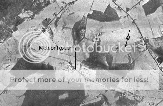
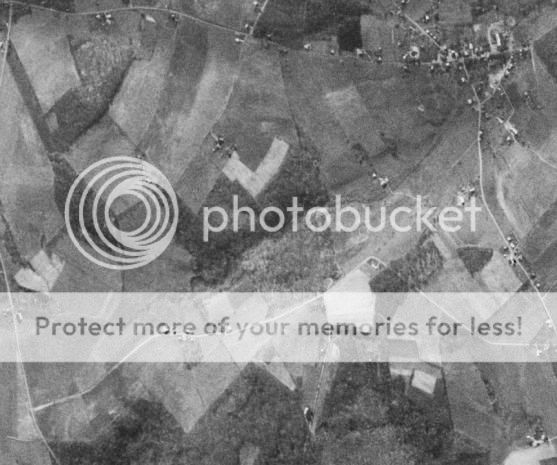
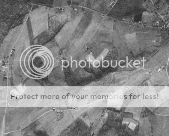
First, what you're seeing here are declassified spy-satellite images of the Kecksburg, Pa, area, and specifically the wooded area just south of what is now known as Meteor Road where, on December 9, 1965, something reportedly fell from the sky and was recovered by the US mlitary.
These are sections cut from the original images, which I didn't post because they are 4-part, 1.2 Gigabyte TIFs. Luckily I have a pair of 100G drives at home but those huge TIFs are still a bear to work with.
If something crashed into the woods, there should be evidence in the form of broken tree tops, branches, truck tire marks, etc. The producers of History Channel's Kecksburg special chose to look for disturbed layers of dirt, and use tree-rings to imply that somthing stressful happened to some trees in 1965. I decided to check out the aerials, instead. The shots are from two years before and one year after the Kecksburg event. If anything changed during that time, say in December, 1965, the marks should be visible in the 1966 images. The 1963 image shows bare trees and, suitably enhanced, can reveal the ground pretty well. The 1966 shots are a stereo pair and could potentially show any tree-top damage.
I could tell from preview images, using Terraserver images from the 90's, that very little had actually changed in the Kecksburg area since 1965, so I ordered the full-size images from UGSG. (There are some higher-resolution shots from a few years later available, but I'm not rich and my wife will stand just so much, y'know )
I was hoping that any recent damage would be apparent and provide some hard evidence about whether something had actually crashed into the forest there.
As I originally said, these are sections of the raw images, just as I got them, posted just as soon as I got them, so anybody could look them over, dissect them, etc., and see if there is any evidence of military activity.
Now that I've had a brief chance to look at them briefly, I don't see any overwhelming evidence of a crash site, although there are tantalizing hints. However, I found something I didn't expect: at least one of the shots from 1966 shows signs of tampering. Specifically, the frame appears to have been assembled from at least two different images, and the splice goes right through the eastern edge of a certain wooded area south of Meteor Road near Kecksburg, Pa. You can't see it on these images, unfortunately, but one of the raw images linked above shows it quite well.
I'll let you know more when I know more. In the meantime, if anyone wants to take a hard look at the images, I'd be personally grateful.
Kecksburg Theory.
What landed in PA was a Russian warhead or warhead dummy from one of the earlier ICBMs. The shape was often said to be that of an acorn which is the shape of the early ICBM warheads. images.google.com...,GGGL:2005-09,GGGL:en&start=20&sa=N
As to why it was over the US or landed in PA, that would be even greater speculation.
That isn't evidence of tampering I'm afraid, it was, and is still, common to produce arial photographs by making multiple passes of an area and
photographing in strips, which are then assembled into a single larger image, a slight change in either altitude, or attitude of the aircraft between
taking one strip and a second pass for the next strip make it hard to photograph the area at exactly the same angle each pass, so there will be
edges that don't seem to match fully.
Anglo.
Anglo.
Originally posted by anglodragon
That isn't evidence of tampering I'm afraid, it was, and is still, common to produce arial photographs by making multiple passes of an area and photographing in strips, which are then assembled into a single larger image, a slight change in either altitude, or attitude of the aircraft between taking one strip and a second pass for the next strip make it hard to photograph the area at exactly the same angle each pass, so there will be edges that don't seem to match fully.
Anglo.
Except that these are supposedly scanned directly from the original KH-4 Corona films, which are exposed as a single panoramic image in a strip 2.25 x 30 inches.
samadhi.jpl.nasa.gov...
There should be NO splices, especially electronic (e.g., Photoshop).
According to the USGS database, there were only two frames taken of that particular piece of ground in 1966, one from the forward camera, and one from the aft camera, and I have both of them.


So where did the extra piece of image come from? That's the question now.
I've looked at the photo's could only find two distincted markings,
are these the areas that you are suggesting are the before and after crash site?
kecksburg - a

kecksburg - b

are these the areas that you are suggesting are the before and after crash site?
kecksburg - a
kecksburg - b
new topics
-
Thousands Of Young Ukrainian Men Trying To Flee The Country To Avoid Conscription And The War
Other Current Events: 1 hours ago -
12 jurors selected in Trump criminal trial
US Political Madness: 4 hours ago -
Iran launches Retalliation Strike 4.18.24
World War Three: 4 hours ago -
Israeli Missile Strikes in Iran, Explosions in Syria + Iraq
World War Three: 4 hours ago -
George Knapp AMA on DI
Area 51 and other Facilities: 10 hours ago -
Not Aliens but a Nazi Occult Inspired and then Science Rendered Design.
Aliens and UFOs: 10 hours ago
top topics
-
BREAKING: O’Keefe Media Uncovers who is really running the White House
US Political Madness: 17 hours ago, 26 flags -
George Knapp AMA on DI
Area 51 and other Facilities: 10 hours ago, 25 flags -
Israeli Missile Strikes in Iran, Explosions in Syria + Iraq
World War Three: 4 hours ago, 13 flags -
Louisiana Lawmakers Seek to Limit Public Access to Government Records
Political Issues: 12 hours ago, 7 flags -
So I saw about 30 UFOs in formation last night.
Aliens and UFOs: 16 hours ago, 6 flags -
Iran launches Retalliation Strike 4.18.24
World War Three: 4 hours ago, 5 flags -
Not Aliens but a Nazi Occult Inspired and then Science Rendered Design.
Aliens and UFOs: 10 hours ago, 5 flags -
Do we live in a simulation similar to The Matrix 1999?
ATS Skunk Works: 16 hours ago, 4 flags -
The Tories may be wiped out after the Election - Serves them Right
Regional Politics: 14 hours ago, 3 flags -
12 jurors selected in Trump criminal trial
US Political Madness: 4 hours ago, 3 flags
active topics
-
President BIDEN Warned IRAN Not to Attack ISRAEL - Iran Responded with a Military Attack on Israel.
World War Three • 43 • : WeMustCare -
Israeli Missile Strikes in Iran, Explosions in Syria + Iraq
World War Three • 52 • : WeMustCare -
Mandela Effect - It Happened to Me!
The Gray Area • 107 • : inflaymes69 -
Terrifying Encounters With The Black Eyed Kids
Paranormal Studies • 45 • : daskakik -
Not Aliens but a Nazi Occult Inspired and then Science Rendered Design.
Aliens and UFOs • 12 • : BeyondKnowledge3 -
Elites disapearing
Political Conspiracies • 31 • : Degradation33 -
MULTIPLE SKYMASTER MESSAGES GOING OUT
World War Three • 47 • : SchrodingersRat -
12 jurors selected in Trump criminal trial
US Political Madness • 21 • : VictorVonDoom -
British TV Presenter Refuses To Use Guest's Preferred Pronouns
Education and Media • 64 • : Degradation33 -
Iran launches Retalliation Strike 4.18.24
World War Three • 14 • : Cloudbuster1