It looks like you're using an Ad Blocker.
Please white-list or disable AboveTopSecret.com in your ad-blocking tool.
Thank you.
Some features of ATS will be disabled while you continue to use an ad-blocker.

Fantasy Island
page: 1share:
Anyone have a line on this place?
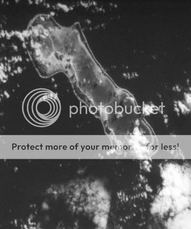
It's in the middle of the Pacific (and I do mean MIDDLE; it's like exactly between Australia and South America) at:
17'18'00'S, 145'39'54'W
It's about 10 miles long and one wide.
I haven't found it on a map yet; unfortunately (I suppose) I don't do Windows, so I can't get to the newest mapping stuff.
TIA
Cant be sure what its name may be.
But I swear I see a boat on the beach . With gilligan the skipper two
a millionair and you know the rest. lol
ps couldent resist.
But I swear I see a boat on the beach . With gilligan the skipper two
a millionair and you know the rest. lol
ps couldent resist.
OMG LOL IT'S THE ISLAND FROM LOST!!!!!!!
That's a nice find, chances are it's already some tourist place though.
That's a nice find, chances are it's already some tourist place though.
Beat me to it Nventual. Should post this on a lost forum haha
But no never have heard of it, looks like a old picture you sure its not on google earth? I have it on my other comp but its screwed.
If someone has goodle earth please posts pics of the island.
But no never have heard of it, looks like a old picture you sure its not on google earth? I have it on my other comp but its screwed.
If someone has goodle earth please posts pics of the island.
I'm looking at that area in Google Earth, there's nothing there?
It sure does look like the island from Lost though, and the plane did take off from Australia, so..
It sure does look like the island from Lost though, and the plane did take off from Australia, so..
This will drive the losties crazy if it turns to be true haha
Rand, can you give the source of where you got the photo, and how you know its at those co-ordinates aswell?
Rand, can you give the source of where you got the photo, and how you know its at those co-ordinates aswell?
Actually, the Lost island is filmed in Oahu, so, uh, yeah.
www.crewpix.com..." target="_blank" class="postlink">I see Hurley in the backround!
I love Lost, lol sorry for going off-topic.
www.crewpix.com..." target="_blank" class="postlink">I see Hurley in the backround!
I love Lost, lol sorry for going off-topic.
There's gotta still be unmapped islands out there. Too many small pieces of land exist in the oceans. However, I would be interested to know what it
is exactly now that I saw it.
Google Earth doesn't help much.
I left the gridline on for the pic to show it's probably the same one.
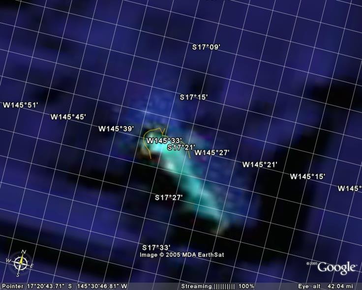
According to Google, the yellow bit up at the top is a road so someone must be there, but it won't say a name!
[edit on 1-8-2006 by Djarums]
I left the gridline on for the pic to show it's probably the same one.
According to Google, the yellow bit up at the top is a road so someone must be there, but it won't say a name!
[edit on 1-8-2006 by Djarums]
Hmmm...
Here's the deal: this little fly-speck has been the subject of at least 41 images on 20-some Corona missions over at least 2 decades. I really don't think the CIA needed maps that were THAT good. The spooks were looking for something.
This is from a stero pair at slightly higher seolution.
There is something on the beach, something that doesn't show on other frames. It the size of a huntchback whale -- maybe it is a beached whale, but there's no rotting carcase on later images That's a pretty substantial coral reef out there, so I don't think it would be a ship, unless it were thrown there by a typhoon.
Now the question is, "Is it worth 113 USD to get a better look?", because that's what it would cost to order the set in 1-meter resolution.
If it has been the target of so many Corona missions, and that it is in the Pacific, may I suggest that it is the site of nuclear testing?
From these images, I can't see any blast marks, but the US, France & the UK all did testing in the Pacific.
Just a guess
From these images, I can't see any blast marks, but the US, France & the UK all did testing in the Pacific.
Just a guess
Hi,
Is is not just one of the North Mariana Islands? They are a chain of islands under the protection of the U.S. Guam (probrably one of America's most important bases is just south of here, so it makes sense that the CIA keep an eye or two on neighbouring islands?
Cheers
Robbie
Is is not just one of the North Mariana Islands? They are a chain of islands under the protection of the U.S. Guam (probrably one of America's most important bases is just south of here, so it makes sense that the CIA keep an eye or two on neighbouring islands?
Cheers
Robbie
Its called Anaa.
It is in the Tuamotu Islands of French Polynesia. It has an Airport( Anaa -size unknown)
Small in size with no reef pass, this atoll was the birthplace of the royal Pomare family and was also renowned in days gone by for its fierce conquering warriors.
Since those times the island has become more friendly and now lives at the slow pace of the traditional activities of fishing and coprah making around the village of Tukuhora.
[edit on 9-1-2006 by ajsr71]
[edit on 9-1-2006 by ajsr71]
What's amazing is how remote it is... When I need a break from the world, I'm going there!!
It must be an interesting experience to literally be in the middle of no where.
It must be an interesting experience to literally be in the middle of no where.
Originally posted by ajsr71
Its called Anaa.
It is in the Tuamotu Islands of French Polynesia. It has an Airport (Anaa -size unknown)
Thanks! With that I was able to locate some decent maps of the island. It seems the object was sitting on or hovering over the airstrip. I'll let you know if I come up with anything else.
Anyone heard anything to verify this?
Overheard Conversation at Bullfeathers two years ago
Two men in black suits sharing a bottle talking about a small group of U.S. territorial islands. Summary of the conversation.
Plan to utilize the northern most islands of the Marianas islands
- The islands of Uracas or Farallon de Pajaros, Maug and Asuncion meet all the requirements to continue with the project. They are remote, uninhabited, and uniquely, owned by us.
- Location is within the earth’s magnetic flux zone, similar in nature to the requirements of the 1940 geographical location.
- The islands are seldom called on, even by fishermen.
To secure the islands for our operational needs we intend to acquire them under the guise of a Pew Charitable Trusts and designate of the area as the “Mariana Trench Marine National Monument”
We are prepared to fund a lobby group, solicit tree hugger volunteers to join the group, promoting the environmental benefits of setting this area aside from visitations from the rest of world.
To be sure there is no army stronger and more prolific than those that carry the save the whale flag. We shall utilize this force to our benefit; convince any local indigenous group of the wise decision to simply just give us the area. There is no need for glass beads or smallpox laden blankets anymore as long as we have the Greenies on our side.
Suggest we advise the President, make the necessary resource allocations and send this to planning for implementation.
I can tell you that this is happing today. Saipan island is awash with political activist types bent on support to remove a huge part of the Commonwealth of the Northern Mariana islands and make it disappear from the map. All for what real purpose?
there's a ton of little island chains and islets all over the pacific. especially around fiji. 300+.
a lot of them are privately owned. sure would be a great way of life.
good call on anaa.
a lot of them are privately owned. sure would be a great way of life.
good call on anaa.
new topics
-
We need less laws in the UK not more
General Chit Chat: 1 hours ago -
The Baloney aka BS Detection Kit
Social Issues and Civil Unrest: 6 hours ago -
Suspected Iranian agent working for Pentagon while U.S. coordinated defense of Israel
US Political Madness: 6 hours ago -
How does my computer know
Education and Media: 9 hours ago
top topics
-
Suspected Iranian agent working for Pentagon while U.S. coordinated defense of Israel
US Political Madness: 6 hours ago, 12 flags -
USO 10 miles west of caladesi island, Clearwater beach Florida
Aliens and UFOs: 13 hours ago, 9 flags -
The Baloney aka BS Detection Kit
Social Issues and Civil Unrest: 6 hours ago, 4 flags -
How does my computer know
Education and Media: 9 hours ago, 2 flags -
We need less laws in the UK not more
General Chit Chat: 1 hours ago, 0 flags
active topics
-
Running Through Idiot Protestors Who Block The Road
Rant • 57 • : FlyersFan -
It has begun... Iran begins attack on Israel, launches tons of drones towards the country
World War Three • 642 • : CriticalStinker -
Tesla cutting 14,000 jobs
Global Meltdown • 49 • : Vermilion -
NYAG Letitia James Prepares to Begin Seizing TRUMP Assets Even Though There Was No Crime.
Above Politics • 277 • : matafuchs -
Suspected Iranian agent working for Pentagon while U.S. coordinated defense of Israel
US Political Madness • 13 • : Kaiju666 -
Afterlife, unknown, so prepare, or just go into the unknown (bad)!!
ATS Skunk Works • 53 • : CCoburn -
-@TH3WH17ERABB17- -Q- ---TIME TO SHOW THE WORLD--- -Part- --44--
Dissecting Disinformation • 476 • : Degradation33 -
Abortions in first 12 weeks should be legalised in Germany, commission says
Medical Issues & Conspiracies • 13 • : malte86 -
Are the 'Abrahamic Religions' all Really the Worshipping the Same Abrahamic God?
Conspiracies in Religions • 174 • : Sookiechacha -
We Captured a Honey Bee Swarm Today (Video)
Fragile Earth • 20 • : grey580