It looks like you're using an Ad Blocker.
Please white-list or disable AboveTopSecret.com in your ad-blocking tool.
Thank you.
Some features of ATS will be disabled while you continue to use an ad-blocker.

Antarctica was Atlantis
page: 8share:
And you are correct that there are stone structures all around the world, there are many right there in the Mediterreanean region that we know little or nothing about. But I'm not sure what that has to do with anything. Especially the structures that we don't even know who used them. I mean, we can't even speculate about whether or not these[ structures were built with the methods the Egyptians could have used - many of these haven't even been dated. Obviously, they were built by somebody. We have no evidence of any ancient advanced civilization. So until we do (if ever,) it only makes sense to assume the civilizations we know built the structures that (like the pyramids) we at least know something about. Especially when construction experts can devise a perfectly reasonable method for them having done so. As for the structures that we can't date and can't associate with any particular civilization, again, absent any evidence of anything out of the ordinary, it only makes sense to assume these were built by local residents of the areas where they are located. Harte
Do you actually believe that the definition of "PI" was an actual refferance to the number? It is an Abherent" concept. we have invented "PI" for to teach every other young person of our principles of basic "Physics". Though it applies to many of "OUR" mathematical solutions, it does not mean we are correct under the assumptions of it's plausibilities. It was created by "US" the human being's of this planet. If I were you, "I would think out-side the box, before trying to reclaim something that you have 'NO-IDEA' over."
There's no real reason why the Egyptians couldn't have built the Giza pyramids. There's no evidence to suggest any other specific group opf people
built them. And the Egyptians themselves actually claim to have built them.
Oh, and in any case - what relevance has any of this to the slightly bizarre theory that Atlantis was in Antarctica?
Oh, and in any case - what relevance has any of this to the slightly bizarre theory that Atlantis was in Antarctica?
I'm not sure what it is that is being said in these statements, but I assure you that I, at least, absolutely do know about the arguments concerning pi and the pyramids, and I also know that the concept of pi exists wherever there is a closed loop (you know, like maybe even an orbit.)
Originally posted by Allred5923
Do you actually believe that the definition of "PI" was an actual refferance to the number? It is an Abherent" concept. we have invented "PI" for to teach every other young person of our principles of basic "Physics". Though it applies to many of "OUR" mathematical solutions, it does not mean we are correct under the assumptions of it's plausibilities. It was created by "US" the human being's of this planet. If I were you, "I would think out-side the box, before trying to reclaim something that you have 'NO-IDEA' over."
Since that is true, I must say here that nobody "invented" pi. Pi was discovered. And sure, pi helps in physics, but it is a mathematical concept, and not a scientific concept.
It's apparent that you have not grasped what pi actually is, and hence it is you that has "NO-IDEA" what you're talking about.
Pi is the ratio of a circle's circumference to it's diameter. Most "pyramid mysteries" sites contain as one of their arguments that the number pi can be found in the Great Pyramid by taking the area of the base divided by the pyramid's height, which results in the number 3.14297.... They usually go on to say that, since the Egyptians didn't know pi, the Great Pyramid must have been built by someone else, someone more advanced than the Egyptians.
Problem is, this number, which admittedly resembles pi, is a relic of the way Egyptians measured angles, nothing more.
Now I've got to go lay down and cry.
Harte
If anyone is interested you might be able to find some more info on this subject by reading the following book:
Title: Fingerprints of the Gods
Author: Graham Hancock
Publisher: Three Rivers Press
ISBN: 0-517-88729-0
Title: Fingerprints of the Gods
Author: Graham Hancock
Publisher: Three Rivers Press
ISBN: 0-517-88729-0
I don't know if anyone is interested, but another possible source of info, on this subject, is a book called Fingerprints of the Gods. The author is
Graham Hancock, and published by Three Rivers Press. It is not exactly about Antarctica being Atlantis, but is does shed some light on the
"history" of Antarctica. Good reading!!!!
Just because you're paranoid, doesn't mean they're not out to get you!
Just because you're paranoid, doesn't mean they're not out to get you!
Sorry about posting the Graham Hancock book info twice. By the way has anyone else heard about the water erosion marks, on the back of the Sphinx.
Originally posted by flighttraumajunkie
I don't know if anyone is interested, but another possible source of info, on this subject, is a book called Fingerprints of the Gods. The author is Graham Hancock, and published by Three Rivers Press. It is not exactly about Antarctica being Atlantis, but is does shed some light on the "history" of Antarctica. Good reading!!!!
Just because you're paranoid, doesn't mean they're not out to get you!
Check this thread coz Fingerprints of the Gods and G Hancock has been discussed...
I first kind of blew off this whole Antarctica and Atlantis thing until I saw the Piri Reis map. Is anyone familiar with this? Sorry if it's
already been discussed or even debunked maybe; if so, skip over this post.
Piri Reis map most likely has been discussed in other threads but don't mention that cos since has been analysed by G. Hancock for some members here
is a lost argument and not worth to mention it.
In short, the Piri Reis map was drawn up in roughly 1500 by an Ottoman cartographer. It is similiar to many other maps of that age which show a
southern continent, not because it (the southern continent) had been mapped but because it was assumed one must exist. The Americas, as depicted on
the map, are probably a mixture of the maps of Colombus as interepreted by Piri Reis in the context of Asia. Its a wonderful map but horribly
misinterpreted by the true believers.
Piri Reis map depicts olso Antarcitc not only America. I don't see the misinterpretation here and speculation. Thing are written black on white. Here
is an excerpt from the answer of HAROLD Z. OHLMEYER Lt Colonel, USAF Commander to Prof. Charles Hapgood in the relation with the Piri Reis map:
Despite the deadpan language, Ohlmeyer’s letter is a bombshell. If Queen Maud Land was mapped before it was covered by ice, the original cartography must have been done an extraordinarily long time ago.
In attempting that explanation it is worth reminding ourselves of the basic historical and geological facts:
1 The Piri Reis Map, which is a genuine document, not a hoax of any kind, was made at Constantinople in AD 1513.3
2 It focuses on the western coast of Africa, the eastern coast of South
America and the northern coast of Antarctica.
3 Piri Reis could not have acquired his information on this latter region from contemporary explorers because Antarctica remained undiscovered until AD 1818,4 more than 300 years after he drew the map.
4 The ice-free coast of Queen Maud Land shown in the map is a colossal puzzle because the geological evidence confirms that the latest date it could have been surveyed and charted in an ice-free condition is 4000 BC.
5 It is not possible to pinpoint the earliest date that such a task could have been accomplished, but it seems that the Queen Maud Land littoral may have remained in a stable, unglaciated condition for at least 9000 years before the spreading ice-cap swallowed it entirely
6 There is no civilization known to history that had the capacity or need to survey that coastline in the relevant period: between 13,000 BC and 4000 BC.

In other words, the true enigma of this 1513 map is not so much its inclusion of a continent not discovered until 1818 but its portrayal of part of the coastline of that continent under ice-free conditions which came to an end 6000 years ago and have not since recurred.
How can this be explained? Piri Reis obligingly gives us the answer in a series of notes written in his own hand on the map itself. He tells us that he was not responsible for the original surveying and cartography. On the contrary, he admits that his role was merely that of compiler and copyist and that the map was derived from a large number of source maps.
Some of these had been drawn by contemporary or near-contemporary explorers (including Christopher Columbus), who had by then reached South America and the Caribbean, but others were documents dating back to the fourth century BC or earlier.
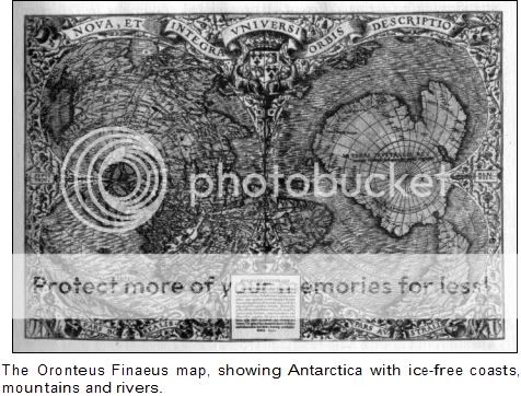
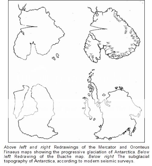
But Piri Reis is not the only map. We have the map drawn by Oronteus Finaeus in 1531. And here are Hapgoods coments about this map:
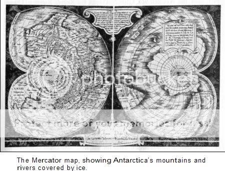
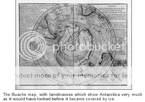
Then we have Mercator and Buache's maps that show the same thing:
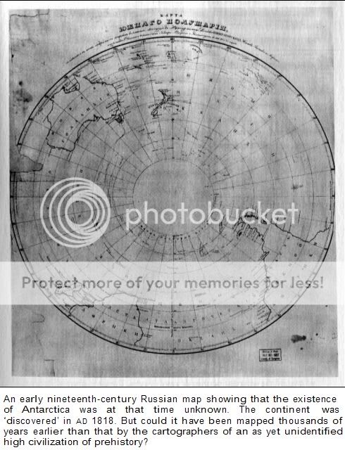
And is another drawing or map done by Russians.
The combined effect of the Piri Reis, Oronteus Finaeus, Mercator and Buache Maps is the strong, though disturbing, impression that Antarctica may have been continuously surveyed over a period of several thousands of years as the ice-cap gradually spread outwards from the interior, increasing its grip with every passing millennium but not engulfing all the coasts of the southern continent until around 4000 BC. The original sources for the Piri Reis and Mercator Maps must therefore have been prepared towards the end of this period, when only the coasts of
Antarctica were free of ice; the source for the Oronteus Finaeus Map, on the other hand, seems to have been considerably earlier, when the ice- cap was present only in the deep interior of the continent; and the source for the Buache Map appears to originate in even earlier period (around13,000 BC), when there may have been no ice in Antarctica at all.
[edit on 17-8-2006 by Telos]
8 RECONNAISSANCE TECHNICAL SQUADRON (SAC) UNITED STATES AIRFORCE
Westover Airforce Base
Massachusetts
6 July 1960
SUBJECT: Admiral Piri Reis World Map To: Professor Charles H. Hapgood, Keene College,
Keene, New Hampshire.
Dear Professor Hapgood,
Your request for evaluation of certain unusual features of the Piri Reis World Map of
1513 by this organization has been reviewed.
The claim that the lower part of the map portrays the Princess Martha Coast of Queen Maud Land Antarctica, and the Palmer Peninsula, is reasonable. We find this is the most logical and in all probability the correct interpretation of the map.
The geographical detail shown in the lower part of the map agrees very remarkably with the results of the seismic profile made across the top of the ice-cap by the Swedish- British Antarctic Expedition of 1949.
This indicates the coastline had been mapped before it was covered by the ice-cap.
The ice-cap in this region is now about a mile thick.
We have no idea how the data on this map can be reconciled with the supposed state of geographical knowledge in 1513.
HAROLD Z. OHLMEYER Lt Colonel, USAF Commander
Despite the deadpan language, Ohlmeyer’s letter is a bombshell. If Queen Maud Land was mapped before it was covered by ice, the original cartography must have been done an extraordinarily long time ago.
In attempting that explanation it is worth reminding ourselves of the basic historical and geological facts:
1 The Piri Reis Map, which is a genuine document, not a hoax of any kind, was made at Constantinople in AD 1513.3
2 It focuses on the western coast of Africa, the eastern coast of South
America and the northern coast of Antarctica.
3 Piri Reis could not have acquired his information on this latter region from contemporary explorers because Antarctica remained undiscovered until AD 1818,4 more than 300 years after he drew the map.
4 The ice-free coast of Queen Maud Land shown in the map is a colossal puzzle because the geological evidence confirms that the latest date it could have been surveyed and charted in an ice-free condition is 4000 BC.
5 It is not possible to pinpoint the earliest date that such a task could have been accomplished, but it seems that the Queen Maud Land littoral may have remained in a stable, unglaciated condition for at least 9000 years before the spreading ice-cap swallowed it entirely
6 There is no civilization known to history that had the capacity or need to survey that coastline in the relevant period: between 13,000 BC and 4000 BC.
In other words, the true enigma of this 1513 map is not so much its inclusion of a continent not discovered until 1818 but its portrayal of part of the coastline of that continent under ice-free conditions which came to an end 6000 years ago and have not since recurred.
How can this be explained? Piri Reis obligingly gives us the answer in a series of notes written in his own hand on the map itself. He tells us that he was not responsible for the original surveying and cartography. On the contrary, he admits that his role was merely that of compiler and copyist and that the map was derived from a large number of source maps.
Some of these had been drawn by contemporary or near-contemporary explorers (including Christopher Columbus), who had by then reached South America and the Caribbean, but others were documents dating back to the fourth century BC or earlier.
But Piri Reis is not the only map. We have the map drawn by Oronteus Finaeus in 1531. And here are Hapgoods coments about this map:
1 It had been copied and compiled from several earlier source maps drawn up according to a number of different projections.
2 It did indeed show non-glacial conditions in coastal regions of Antarctica, notably Queen Maud Land, Enderby Land, Wilkes Land, Victoria Land (the east coast of the Ross Sea), and Marie Byrd Land.
3 As in the case of the Piri Reis Map, the general profile of the terrain, and the visible physical features, matched closely seismic survey maps of the subglacial land surfaces of Antarctica.
Then we have Mercator and Buache's maps that show the same thing:
The Piri Reis and Oronteus Finaeus Maps therefore provide us with a glimpse of Antarctica as no cartographer in historical times could possibly have seen it. On their own, of course, these two pieces of evidence should not be sufficient to persuade us that we might be gazing at the fingerprints of a lost civilization. Can three, or four, or six such maps, however, be dismissed with equal justification?
And is another drawing or map done by Russians.
The combined effect of the Piri Reis, Oronteus Finaeus, Mercator and Buache Maps is the strong, though disturbing, impression that Antarctica may have been continuously surveyed over a period of several thousands of years as the ice-cap gradually spread outwards from the interior, increasing its grip with every passing millennium but not engulfing all the coasts of the southern continent until around 4000 BC. The original sources for the Piri Reis and Mercator Maps must therefore have been prepared towards the end of this period, when only the coasts of
Antarctica were free of ice; the source for the Oronteus Finaeus Map, on the other hand, seems to have been considerably earlier, when the ice- cap was present only in the deep interior of the continent; and the source for the Buache Map appears to originate in even earlier period (around13,000 BC), when there may have been no ice in Antarctica at all.
[edit on 17-8-2006 by Telos]
Antarctica has been covered by ice for approx 35 million years. This is not a debatable point (well I guess anything is debatable, even positions that
are indefensible) This makes it highly difficult for any ancient civilization to have knowledge of the underlying topography. As always the most
probable answer should not be thrown out simply because it isnt the most interesting. Belief in the existence of a Terra Australis (southern
continent) had existed since the Greeks. The idea was that the northern continents had to be balanced by a southern continent. This continent was
included on many different maps in antiquity and especially on european maps in the 15th-18th centuries.
Well I'm showing you the emperor that is naked and you are telling me that the fact that is naked doesn't prove that he is no wearing any clothes?
Originally posted by mccainz
Antarctica has been covered by ice for approx 35 million years. This is not a debatable point (well I guess anything is debatable, even positions that are indefensible) This makes it highly difficult for any ancient civilization to have knowledge of the underlying topography. As always the most probable answer should not be thrown out simply because it isnt the most interesting. Belief in the existence of a Terra Australis (southern continent) had existed since the Greeks. The idea was that the northern continents had to be balanced by a southern continent. This continent was included on many different maps in antiquity and especially on european maps in the 15th-18th centuries.
35 milion years... according to whom?
You are saying belief in the existence of Terra Australis since the ancien greeks time. But here we're talking about precise maps that demonstrate high knowledge of mathematics and topography.
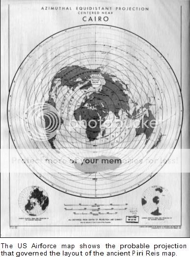
Lorenzo Burroughs, chief of the 8th Reconnaissance Technical Squadron’s Cartographic Section at Westover Air Base, made a particularly close study of the Oronteus Finaeus Map. He concluded that some of the sources upon which it was based must have been drawn up by means of a projection similar to the modern Cordiform Projection. This, said Burroughs:
suggests the use of advanced mathematics. Further, the shape given to the Antarctic Continent suggests the possibility, if not the probability, that the original source maps were compiled on a stereographic or gnomonic type of projection involving the use of spherical trigonometry.
There are many different kinds of projection. Mercator’s, still used in atlases today, is perhaps the most familiar. Others are dauntingly referred to as Azimuthal, Stereographic, Gnomonic, Azimuthal Equidistant, Cordiform, and so on, but it is unnecessary to go into this any further here. We need only note that all successful projections require the use of sophisticated mathematical techniques of a kind supposedly unknown in the ancient world20 (particularly in the deepest antiquity before 4000 BC when there was allegedly no human civilization at all, let alone one capable of developing and using advanced mathematics and geometry).
i'm completly cofused...so where is more possible to be found Atlantis ?
Antartica or Cyprus ?
Antartica or Cyprus ?
Originally posted by Telos
Originally posted by mccainz
Antarctica has been covered by ice for approx 35 million years.
35 milion years... according to whom?
According to all available geological knowledge. Sediment cores, for example:
news.bbc.co.uk...
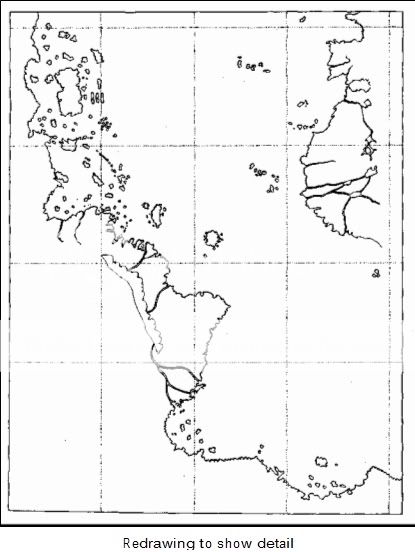
As for the Piri Re'is map - it depicts S America down to Tierra del Fuego. The fact that the entrance to the Staits of Magellan is shown as a bay indicates whoever drew the map did not sail through to the eastern side of the continent:
xoomer.alice.it...
A host of other problems exist with this map and the Antarctica as Atlantis theory. If you ignore the geological evidence from ice-cores and insist
that Antarctica was more or less temperate at the time of Plato's Atlantis then you must explain where all the water from the melting ice went. We
should see a 260 foot spike in sea levels followed by a drop of the same amount as the continent refroze. This would appear in the geologic records as
a sea level roughly 150 feet higher than today's sea level and there is absolutely no evidence for this. Also, you would have to explain how such a
severe localized warming and then refreezing could occur over a single continent in such a short period of time. Remember, glaciation started in
Antarctica 35 million years ago and took many millions of years to sock the continent under. How do we recreate this on a timescale reduced to
accomodate our wildest Atlantean wishes?
Originally posted by Essan
According to all available geological knowledge. Sediment cores, for example:
news.bbc.co.uk...
As for the Piri Re'is map - it depicts S America down to Tierra del Fuego. The fact that the entrance to the Staits of Magellan is shown as a bay indicates whoever drew the map did not sail through to the eastern side of the continent:
xoomer.alice.it...
Eassn I wonder if you read my post. It specifies clearly that the map shows Queen Maud Land and not only Tierra del Fuego. In the map the coast of Queen Mad is ice-free.
I know that the analysis of sediments give us that number but at the other side we have all this maps that are done with high precision and knwoledge of math, geografy and topography. And and this point one of this is gotta be either wrong or incorrect.
In my posts I'm refering to Hapgood which has studied this maps in detailes and so far his theories haven't been proved wrong or at least no counter argument has been suficent to dismiss his explanations.
The Oronteus Finaeus World Map also commands attention: it
successfully places the coasts of Antarctica in correct latitudes and
relative longitudes and finds a remarkably accurate area for the continent
as a whole. This reflects a level of geographical knowledge not available
until the twentieth century.
For more info check Hapgood materials on google or read Fingerprints of the God (has been quoted there so many times).
Originally posted by mccainz
A host of other problems exist with this map and the Antarctica as Atlantis theory. If you ignore the geological evidence from ice-cores and insist that Antarctica was more or less temperate at the time of Plato's Atlantis then you must explain where all the water from the melting ice went. We should see a 260 foot spike in sea levels followed by a drop of the same amount as the continent refroze. This would appear in the geologic records as a sea level roughly 150 feet higher than today's sea level and there is absolutely no evidence for this. Also, you would have to explain how such a severe localized warming and then refreezing could occur over a single continent in such a short period of time. Remember, glaciation started in Antarctica 35 million years ago and took many millions of years to sock the continent under. How do we recreate this on a timescale reduced to accomodate our wildest Atlantean wishes?
Have you ever heard about the mechanism of earth-crust displacement? I'm quoting something from Einstein:
Albert Einstein investigated the possibility that the weight of the ice-caps, which
are not symmetrically distributed about the pole, might cause such a
displacement. Einstein wrote: ‘The earth’s rotation acts on these unsymmetrically
deposited masses, and produces centrifugal momentum that is transmitted to the
rigid crust of the earth. The constantly increasing centrifugal momentum
produced this way will, when it reaches a certain point, produce a movement of
the earth’s crust over the earth’s body, and this will displace the polar regions
towards the equator.
When Einstein wrote these words [1953] the astronomical causes of ice ages were
not fully appreciated. When the shape of the earth’s orbit deviates from a perfect
circle by more than one per cent, the gravitational influence of the sun increases,
exercising more pull on the planet and its massive ice sheets. Their ponderous
weight pushes against the crust and this immense pressure, combined with the
greater incline in the earth’s tilt [another changing factor of the orbital geometry]
forces the crust to shift ...
And this theory is used by them who believe that Antarctica was 2000 miles from the Pol and thus ice-free.
In a displacement, those parts of the earth’s crust which are situated at the North and South Poles (and which are therefore as completely glaciated as Antarctica is today) shift suddenly into warmer latitudes and begin to melt with extraordinary rapidity. Conversely, land that has hitherto been located at warmer latitudes is shifted equally suddenly into the polar zones, suffers a devastating climate change, and begins to vanish under a rapidly expanding ice-cap.
In other words, when huge parts of northern Europe and north America were heavily glaciated in what we think of as the last Ice Age, it was not because of some mysterious slow-acting climatic factor, but rather because those areas of land were then situated much closer to the North Pole than they are today. Similarly, when the Wisconsin and Wurm glaciations began to go into their meltdown at around 15,000 BC the trigger was not global climate change but a shift of the ice-caps into warmer latitudes ...
In other words: there is an Ice Age going on right now—inside the Arctic Circle and in Antarctica.
Originally posted by Telos
Eassn I wonder if you read my post. It specifies clearly that the map shows Queen Maud Land and not only Tierra del Fuego. In the map the coast of Queen Mad is ice-free.
It does not show Queen Maud land. Read the link I posted.
For more info check Hapgood materials on google or read Fingerprints of the God (has been quoted there so many times).
Or, indeed, read Hapgood's own books Just remember that they were written 50 years ago and new research and advances in earth sciences have shown almost everything he says to be erroneous - from ECD to flash frozen mammoths.
Of course, modern research may be wrong - in the same way that Quaoar, Sedna and Xena don't exist because they're not mentioned in books about the solar system written 50 years ago ....
new topics
-
Ditching physical money
History: 1 hours ago -
One Flame Throwing Robot Dog for Christmas Please!
Weaponry: 1 hours ago -
Don't take advantage of people just because it seems easy it will backfire
Rant: 2 hours ago -
VirginOfGrand says hello
Introductions: 2 hours ago -
Should Biden Replace Harris With AOC On the 2024 Democrat Ticket?
2024 Elections: 3 hours ago -
University student disciplined after saying veganism is wrong and gender fluidity is stupid
Education and Media: 5 hours ago -
Geddy Lee in Conversation with Alex Lifeson - My Effin’ Life
People: 7 hours ago -
God lived as a Devil Dog.
Short Stories: 7 hours ago -
Police clash with St George’s Day protesters at central London rally
Social Issues and Civil Unrest: 8 hours ago -
TLDR post about ATS and why I love it and hope we all stay together somewhere
General Chit Chat: 9 hours ago
top topics
-
Hate makes for strange bedfellows
US Political Madness: 11 hours ago, 18 flags -
Who guards the guards
US Political Madness: 14 hours ago, 13 flags -
University student disciplined after saying veganism is wrong and gender fluidity is stupid
Education and Media: 5 hours ago, 11 flags -
Police clash with St George’s Day protesters at central London rally
Social Issues and Civil Unrest: 8 hours ago, 8 flags -
TLDR post about ATS and why I love it and hope we all stay together somewhere
General Chit Chat: 9 hours ago, 7 flags -
Should Biden Replace Harris With AOC On the 2024 Democrat Ticket?
2024 Elections: 3 hours ago, 5 flags -
Has Tesla manipulated data logs to cover up auto pilot crash?
Automotive Discussion: 16 hours ago, 3 flags -
One Flame Throwing Robot Dog for Christmas Please!
Weaponry: 1 hours ago, 2 flags -
Don't take advantage of people just because it seems easy it will backfire
Rant: 2 hours ago, 2 flags -
Geddy Lee in Conversation with Alex Lifeson - My Effin’ Life
People: 7 hours ago, 2 flags
active topics
-
VirginOfGrand says hello
Introductions • 1 • : VirginOfGrand -
Candidate TRUMP Now Has Crazy Judge JUAN MERCHAN After Him - The Stormy Daniels Hush-Money Case.
Political Conspiracies • 740 • : matafuchs -
Should Biden Replace Harris With AOC On the 2024 Democrat Ticket?
2024 Elections • 33 • : BernnieJGato -
Gold and silver prices....woo hoo
History • 84 • : annonentity -
The Democrats Take Control the House - Look what happened while you were sleeping
US Political Madness • 108 • : Zanti Misfit -
Ditching physical money
History • 7 • : TheMisguidedAngel -
BREAKING! Another Bridge Hit by a barge #3 this week.
Mainstream News • 110 • : RookQueen2 -
One Flame Throwing Robot Dog for Christmas Please!
Weaponry • 4 • : Dalamax -
15 Unhealthiest Sodas On The Market
Health & Wellness • 40 • : Freeborn -
Remember These Attacks When President Trump 2.0 Retribution-Justice Commences.
2024 Elections • 47 • : Zanti Misfit