It looks like you're using an Ad Blocker.
Please white-list or disable AboveTopSecret.com in your ad-blocking tool.
Thank you.
Some features of ATS will be disabled while you continue to use an ad-blocker.

Places west of A-51
page: 10
share:
I took these pictures from Google Earth of a place west of A51 (beyond the mountain but not to far), the reason I was looking away from Area 51 was
this: If A-51 Base has so many images taken of it...so few images have been taken of the rest of the actual base. Its possible tunnels exit from the
base miles and miles away. Looking at just the base compound for ansers is tunnle vision...
I forgot the exact locations on Google Earth, but I will get the coordinates next time I'm on the program.
This looks like a bunker of some sort, with ramps up onto the roof. Objects that looks like large AC Vents are noticeable. Some could be vehicles, but some obviously arnt vehicles but infastructure. This place was relativly in the middle of no where.

Here is a dirt airfield not to far from this bunker. Noteable is a jet on the runway with some sort of addition to its right wing (or the wing has fallen off onto the ground?) and a few other various structures, mounds, and possible vehicles. Looks fresh or kepts up at time of images, so its possible that is not a derilect plane.
Judge them as you wish. I will gett the exact coordinates soon as I can.
[edit on 17-11-2005 by Foxe]
EDIT:
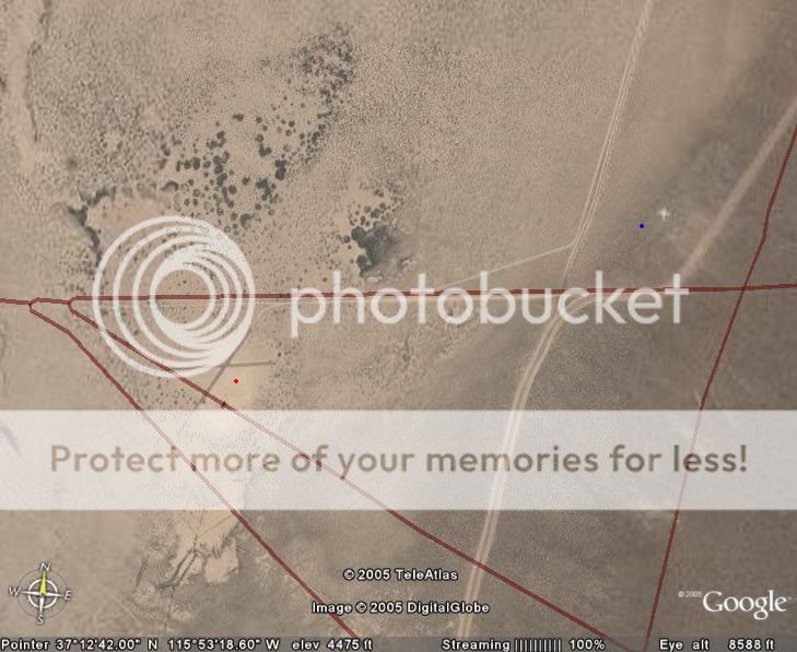
Here is the Google Earth Coordinates.
37 23'56.62 N
116 13'41.83 w
Elev 5437 ft
Look west of A-51, here is an image. Red dot is air field, blue dot is bunkers/junk yard in question, green arrow is pointing towards Groom Lake.

[edit on 17-11-2005 by Foxe]
EDIT:
Another spot found(red spot). Its not a run way either...whats the use of it? Nearby (blue spot) is a crashed jet, looks sort of like a U2 when up close but no way to tell. But it is MUCH bigger than the roads and black X. The X is slightly bigger than the small dirt road which has a turn off onto the X. These roads are not big enough for aircraft unless it was extremely tiny one.
Google Earth Location on image.
[edit on 17-11-2005 by Foxe]
I forgot the exact locations on Google Earth, but I will get the coordinates next time I'm on the program.
This looks like a bunker of some sort, with ramps up onto the roof. Objects that looks like large AC Vents are noticeable. Some could be vehicles, but some obviously arnt vehicles but infastructure. This place was relativly in the middle of no where.
Here is a dirt airfield not to far from this bunker. Noteable is a jet on the runway with some sort of addition to its right wing (or the wing has fallen off onto the ground?) and a few other various structures, mounds, and possible vehicles. Looks fresh or kepts up at time of images, so its possible that is not a derilect plane.
Judge them as you wish. I will gett the exact coordinates soon as I can.
[edit on 17-11-2005 by Foxe]
EDIT:
Here is the Google Earth Coordinates.
37 23'56.62 N
116 13'41.83 w
Elev 5437 ft
Look west of A-51, here is an image. Red dot is air field, blue dot is bunkers/junk yard in question, green arrow is pointing towards Groom Lake.
[edit on 17-11-2005 by Foxe]
EDIT:
Another spot found(red spot). Its not a run way either...whats the use of it? Nearby (blue spot) is a crashed jet, looks sort of like a U2 when up close but no way to tell. But it is MUCH bigger than the roads and black X. The X is slightly bigger than the small dirt road which has a turn off onto the X. These roads are not big enough for aircraft unless it was extremely tiny one.
Google Earth Location on image.
[edit on 17-11-2005 by Foxe]
To me, just to me mind you, the airplane on the apron looks like it is possibly a bone yard airplane.
They tend to look that way (wings hanging off and stuff) after a few years in the desert.
Again this is just my very HUMBLE opinion.
Nice find though with google earth.
You know what they are saying now..."GOOGLE SHALL RULE THE EARTH".
- One Man Short
They tend to look that way (wings hanging off and stuff) after a few years in the desert.
Again this is just my very HUMBLE opinion.
Nice find though with google earth.
You know what they are saying now..."GOOGLE SHALL RULE THE EARTH".
- One Man Short
Thank you sir.
Here is the Google Earth Coordinates.
37 23'56.62 N
116 13'41.83 w
Elev 5437 ft
Look west of A-51, here is an image. Red dot is air field, blue dot is bunkers/junk yard in question, green arrow is pointing towards Groom Lake.
Enjoy.
I do wanna comment this: I am not saying it is a bunker or junk yard, but it is very interesting to what it is out there for...
Originally posted by Foxe
I took these pictures from Google Earth of a place west of A51...
First one is target city, just NE of Area 19.
Second one is target airstrip, just north of that.
Both are within the TTR bombing range. The
airplane skeleton, buildings, vehicles, SAM
emplacements etc are all targets for Red
Flag and other aerial exercises held at TTR.
The last pic is within the A51 boundary, east of
Guard Station 700, the gate between A51 and
the NTS. Best guess of the experts in the area is
that the two runways are UAV runways. They're over
there so that they won't interfere with the
regular air traffic at the main Groom base.
I haven't found a good answer to that white
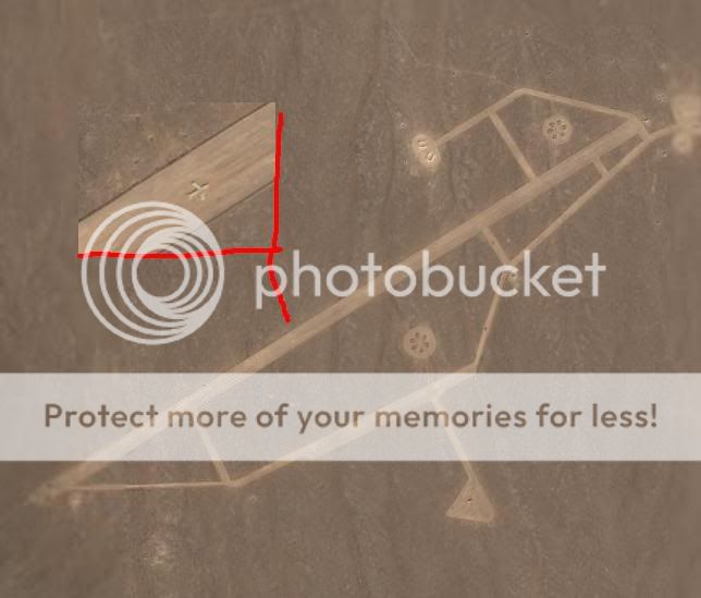
thing that's NE of the UAV runways. Sort of
looks like a plane but too "blocky" as if made
of rectangular stones. The points pretty much
are true NSEW and therefore, to me at least,
suggests some sort of man made compass
orientation object. There are a bunch of those
orientation objects scattered throughout the
Nellis range. Most of the newer ones are huge
laser sighted, cut into the earth, and visible from
commercial airlines flying nearby.
Lots of things that you may find on the sat
photos have already been identified. Go over
to dreamlandresort.com and go to the section
"Maps & GPS" and then download the
"Google Earth Plugin". That will place landmark
points all over the photo and identify spots
that are frequently asked about here.
Sarge
Thank you SgtCamo. Thats why I did not go to deep into what I thought they could be as I was not well versed in what I was looking at. Thank you for
ansering my questions pretty much and directing me to that plug in.
Originally posted by Foxe
Here is a dirt airfield not to far from this bunker. Noteable is a jet on the runway with some sort of addition to its right wing (or the wing has fallen off onto the ground?) and a few other various structures, mounds, and possible vehicles. Looks fresh or kepts up at time of images, so its possible that is not a derilect plane.
[edit on 17-11-2005 by Foxe]
I've seen this before! I can't remember what this airfeild is called, but I know it is used by the airforce to practice Emergency landings on dirt air strips. There is really nothing very exciting about this air strip, what you see, is what's there. I think the name might be listed in the Tom Clancy book: Fighter Wing. Don't get excited, what you see, is what you get.
You found one of the few places in Nellis that really doesn't have any secrets!
The shape are there to simulate obsticals that a pilot would have to look out for during an energency landing, such as building, power lines and roads of different sizes.
Tim
[edit on 22-11-2005 by ghost]
new topics
-
I hate dreaming
Rant: 8 minutes ago -
Is the origin for the Eye of Horus the pineal gland?
General Conspiracies: 1 hours ago -
Man sets himself on fire outside Donald Trump trial
Mainstream News: 2 hours ago -
Biden says little kids flip him the bird all the time.
2024 Elections: 2 hours ago -
The Democrats Take Control the House - Look what happened while you were sleeping
US Political Madness: 2 hours ago -
Sheetz facing racial discrimination lawsuit for considering criminal history in hiring
Social Issues and Civil Unrest: 2 hours ago -
In an Historic First, In N Out Burger Permanently Closes a Location
Mainstream News: 4 hours ago -
MH370 Again....
Disaster Conspiracies: 5 hours ago -
Are you ready for the return of Jesus Christ? Have you been cleansed by His blood?
Religion, Faith, And Theology: 7 hours ago -
Chronological time line of open source information
History: 8 hours ago
top topics
-
In an Historic First, In N Out Burger Permanently Closes a Location
Mainstream News: 4 hours ago, 14 flags -
The Democrats Take Control the House - Look what happened while you were sleeping
US Political Madness: 2 hours ago, 9 flags -
Thousands Of Young Ukrainian Men Trying To Flee The Country To Avoid Conscription And The War
Other Current Events: 15 hours ago, 8 flags -
A man of the people
Medical Issues & Conspiracies: 10 hours ago, 8 flags -
Man sets himself on fire outside Donald Trump trial
Mainstream News: 2 hours ago, 6 flags -
Biden says little kids flip him the bird all the time.
2024 Elections: 2 hours ago, 6 flags -
4 plans of US elites to defeat Russia
New World Order: 11 hours ago, 4 flags -
Are you ready for the return of Jesus Christ? Have you been cleansed by His blood?
Religion, Faith, And Theology: 7 hours ago, 3 flags -
Is the origin for the Eye of Horus the pineal gland?
General Conspiracies: 1 hours ago, 3 flags -
Sheetz facing racial discrimination lawsuit for considering criminal history in hiring
Social Issues and Civil Unrest: 2 hours ago, 3 flags
0