It looks like you're using an Ad Blocker.
Please white-list or disable AboveTopSecret.com in your ad-blocking tool.
Thank you.
Some features of ATS will be disabled while you continue to use an ad-blocker.

Earth during the Cretaceous
page: 10
share:
During the Cretaceous Period ('K') the earth's tectonic plates were more or less in positions similar to what they were today, and there was an
hothouse condition (for earth anyway). There was no ice at the poles, sea levels were high, temperature was high, and the concentration of Carbon
Dioxid (CO2) was high.
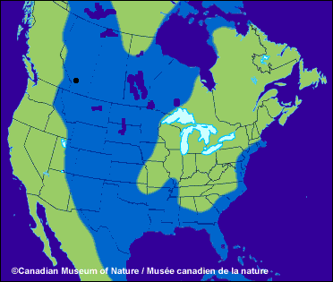
IOW, this is what happens to north america in a greenhouse condition:
This is what happens to the world at large:
Unfortunately, there wouldn't be these guys swimming over the ocean floor (nebraska, wyomming, etc), if it happens again
HOWEVER[/size=2], these kinds of things don't happen quickly.
IOW, this is what happens to north america in a greenhouse condition:
This is what happens to the world at large:
Unfortunately, there wouldn't be these guys swimming over the ocean floor (nebraska, wyomming, etc), if it happens again
HOWEVER[/size=2], these kinds of things don't happen quickly.
Thanks for this information Nygdan .
I live here at the black dot. Underwater
About an hour from where I live is the Royal Tyrrell Museum. It is all of prehistoric life, fossils and such. "world's most extensive collection of dinosaur fossils." Being at the bottom of the sea made for great conditions to create fossils.
Alberta's west border is made by the Rocky Mountains. In this picture the mountains are under water. I wonder if the Rockies were there during the the Cretaceous Period. If not, I wonder if the caps totally melt, would it change this map?
[edit on 3/10/2005 by Umbrax]
Originally posted by Umbrax
I live here at the black dot.
Thankyou. We are adjusting the ATS firing batteries range and distance inputs now. j/k
Being at the bottom of the sea made for great conditions to create fossils.
Having Phil Currie no doubt helps out too!
I wonder if the Rockies were there during the the Cretaceous Period.
The Rockies are very intersting. They were formed during the cretaceous, I'm not entirely sure how this particular map was drawn up, but it might even be before the rockies were uplifted. The Rockies are very young, and indeed its impressive, I think anyway, to see the action of erosion upon mountains, at one point, the appalachians in the eastern half of the continent were just about as high and sharp as the rockies are today, they're simply so old that they've been ground down and smoothed out.
new topics
-
Former Labour minister Frank Field dies aged 81
People: 1 hours ago -
SETI chief says US has no evidence for alien technology. 'And we never have'
Aliens and UFOs: 2 hours ago -
This is our Story
General Entertainment: 5 hours ago -
President BIDEN Vows to Make Americans Pay More Federal Taxes in 2025 - Political Suicide.
2024 Elections: 7 hours ago -
Ode to Artemis
General Chit Chat: 8 hours ago -
Ditching physical money
History: 11 hours ago
0