It looks like you're using an Ad Blocker.
Please white-list or disable AboveTopSecret.com in your ad-blocking tool.
Thank you.
Some features of ATS will be disabled while you continue to use an ad-blocker.

Found Something Weird In Katrina Satellite Pic
page: 1-1
share:
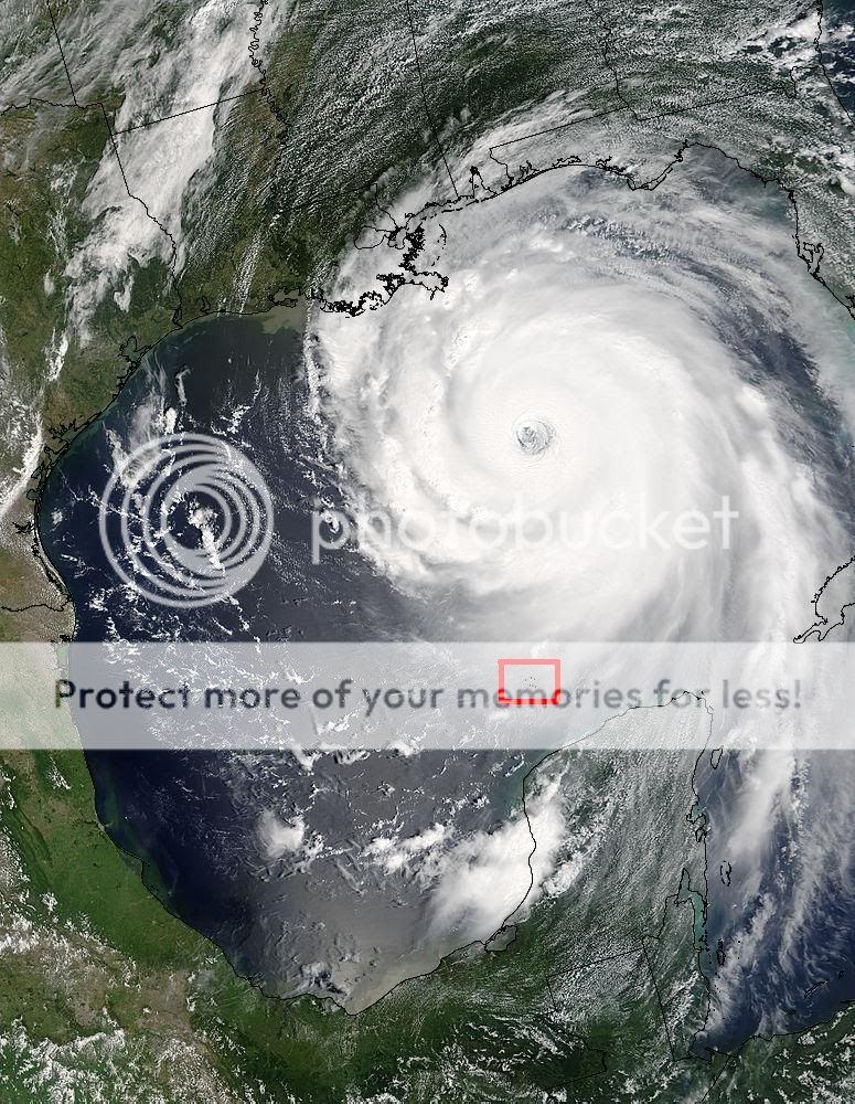
I Found Something Weird In Katrina Satellite Pic. Not Much More To Say. I Was Just Looking At The Pic And Noticed a Weird Cluster Of Black Dots. I
Don't Know If They Are Planes But The Don't Look Right. Please Tell Me Whats You Think.
Please Tell Me What You Think. I Think The Dots Look Out Of Place Tell Me What I Could Be.
[edit on 11-9-2005 by DJDOHBOY]
Please Tell Me What You Think. I Think The Dots Look Out Of Place Tell Me What I Could Be.
[edit on 11-9-2005 by DJDOHBOY]

They look like an error from the boundry lines. Same colour, 1 pixel.
BTW: This is way off from being in the right forum.
BTW: This is way off from being in the right forum.
If A Mod Want To Move This Feel Free I don't Know Where It Belongs.
It would belong in the Aliens & UFOs part of the forum, not the NEWS part, and stop making so many posts within such a small timeframe.
Sorta looks like someone just put the image into paint, and took like that pencil thing and dotted it. Nothing wierd, could be anything. What did you
think it was?
I Put The Red Around It. If You Zoom It In You Can Tell The Dots Are Not Penciled In. I Think It Might Be Military Planes Possibally Hurricane Hunter
But I Don't Know.
No, paint does work well, I just tried it, using black and the paintbrush tool on the smallest setting looks exactly like it. Also I doubt a plane
would show up that well.
Planes are WAY to small to be able to be seen that big from that high up.
It would be an error from when they were drawing the black line around the states and boundries.
It would be an error from when they were drawing the black line around the states and boundries.
You're probaly right actually. There's another lot down the bottom on the right.
Its what looks like a coral atol to me. I couldnt find a map with it named but its definately earthly and the product of a border overlay:

Heres the original satellite view I got from google maps (because I cant use Imageready for crap and it looks all grainy in the animation ):

Nice find though, keep on scouring
Heres the original satellite view I got from google maps (because I cant use Imageready for crap and it looks all grainy in the animation ):
Nice find though, keep on scouring
Nice find ...
In Laymen terms that is what we call a " steering mechanism" ....lol
I do not know what its inventors call it ..
You don't believe a 1degree rise in ocean temperatures could create 2.5 times as any storms per year do you?
They are using lasers to heat ocean grids and then launching these storms via cyclone force winds that they are also generating, in hope of steering one in the right direction, according to wind current.
I don't know, what is it? I give up ..
~peace
As you can see from this map it's a series of small islands and coral reefs.

new topics
-
Tucker on Joe Rogan talking Kona Blue and UFOs
Aliens and UFOs: 1 minutes ago -
Remember These Attacks When President Trump 2.0 Justice-Retribution Commences.
2024 Elections: 44 minutes ago -
Predicting The Future: The Satanic Temple v. Florida
Conspiracies in Religions: 52 minutes ago -
WF Killer Patents & Secret Science Vol. 1 | Free Energy & Anti-Gravity Cover-Ups
General Conspiracies: 2 hours ago -
Hurt my hip; should I go see a Doctor
General Chit Chat: 3 hours ago -
Israel attacking Iran again.
Middle East Issues: 4 hours ago -
Michigan school district cancels lesson on gender identity and pronouns after backlash
Education and Media: 4 hours ago -
When an Angel gets his or her wings
Religion, Faith, And Theology: 5 hours ago -
Comparing the theology of Paul and Hebrews
Religion, Faith, And Theology: 6 hours ago -
Pentagon acknowledges secret UFO project, the Kona Blue program | Vargas Reports
Aliens and UFOs: 7 hours ago
top topics
-
The Democrats Take Control the House - Look what happened while you were sleeping
US Political Madness: 11 hours ago, 18 flags -
In an Historic First, In N Out Burger Permanently Closes a Location
Mainstream News: 13 hours ago, 16 flags -
Man sets himself on fire outside Donald Trump trial
Mainstream News: 10 hours ago, 9 flags -
Biden says little kids flip him the bird all the time.
Politicians & People: 10 hours ago, 9 flags -
Michigan school district cancels lesson on gender identity and pronouns after backlash
Education and Media: 4 hours ago, 7 flags -
WF Killer Patents & Secret Science Vol. 1 | Free Energy & Anti-Gravity Cover-Ups
General Conspiracies: 2 hours ago, 6 flags -
Pentagon acknowledges secret UFO project, the Kona Blue program | Vargas Reports
Aliens and UFOs: 7 hours ago, 6 flags -
Israel attacking Iran again.
Middle East Issues: 4 hours ago, 5 flags -
Remember These Attacks When President Trump 2.0 Justice-Retribution Commences.
2024 Elections: 44 minutes ago, 4 flags -
Boston Dynamics say Farewell to Atlas
Science & Technology: 7 hours ago, 4 flags
active topics
-
Tucker on Joe Rogan talking Kona Blue and UFOs
Aliens and UFOs • 0 • : pianopraze -
Remember These Attacks When President Trump 2.0 Justice-Retribution Commences.
2024 Elections • 8 • : WeMustCare -
MULTIPLE SKYMASTER MESSAGES GOING OUT
World War Three • 55 • : annonentity -
Predicting The Future: The Satanic Temple v. Florida
Conspiracies in Religions • 5 • : Degradation33 -
Israel attacking Iran again.
Middle East Issues • 28 • : KrustyKrab -
In an Historic First, In N Out Burger Permanently Closes a Location
Mainstream News • 11 • : TheMisguidedAngel -
Michigan school district cancels lesson on gender identity and pronouns after backlash
Education and Media • 9 • : TheMisguidedAngel -
Mood Music Part VI
Music • 3064 • : MRTrismegistus -
Man sets himself on fire outside Donald Trump trial
Mainstream News • 41 • : TheMisguidedAngel -
The New, New ATS Members Photos thread. Part 3.
Members • 1653 • : zosimov
-1