It looks like you're using an Ad Blocker.
Please white-list or disable AboveTopSecret.com in your ad-blocking tool.
Thank you.
Some features of ATS will be disabled while you continue to use an ad-blocker.

Area 51 mounds and craters
page: 1share:
Hello there,
I was just fooling about with Google Earth taking a peek at Area 51.
G.E is pretty cool, you can zoom right in.
Anyway, I was looking about the surrounding area and spotted some strange "landmarks".
I'm not sure what they are but here are some links to the pics
This first one is showing where, in comparison to Area 51 I was looking (lower left)
i8.photobucket.com...
The rest of them are just close ups of the "craters" and "mounds".
i8.photobucket.com...
i8.photobucket.com...
i8.photobucket.com...
i8.photobucket.com...
Also, has anyone looked around Area 51 on high zoom (probably a silly question ) and noticed what looks like a door leading down into the ground?
You probably all have seen this but I haven't and was just wondering if anyone could shed some light for me please.
i8.photobucket.com...
Another close up:
i8.photobucket.com...
Any help would be great.
p.s: Anyone think they could've faked a moon landing in the area with all of those craters???
[edit on 1/9/2005 by redize]
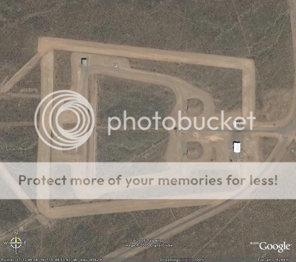
It's an underground hangar for something. They tow the planes right in and out of it onto the ramp.
Why are they using underground hangars to store their aircraft when they have hangars outside?
Doesn't it seem more convenient to store them somewhere more easily accessible than underground?
That seems odd.
Any ideas about the craters and hills/mounds?
Doesn't it seem more convenient to store them somewhere more easily accessible than underground?
That seems odd.
Any ideas about the craters and hills/mounds?
All those craters are from nuclear bomb testing. There's one really large one at the North end. It's big enough that it actually it's very
noticeable with the 3d terrain.
i'm glad i'm not the only freak "googling" area 51 with google earth but yes that a underground hangar and theres 5 more south west of the one u
circle even though the one u circled is the biggest and if u notice the biggest runway is 4.6 miles long oh ya those bumps and stuff are from
underground bombs going of because thats the bombing range =D
i've been looking there for about 3 weeks staight its neato eh? oh ya i'll soo u the 5 hangars i'm talking about
[edit on 1-9-2005 by Lamagraa]
i've been looking there for about 3 weeks staight its neato eh? oh ya i'll soo u the 5 hangars i'm talking about
[edit on 1-9-2005 by Lamagraa]
Area 51 started life as a nuclear testing ground. That's why they chose it when they saw it. As far as the underground hangars, it's safer to hide
things underground than in a building. There could be any number of reasons to keep it underground. There could be specialized equipment under
there, or it could use special fuel that is safer to keep underground where they can control the environment better...... Those are just a couple
reasons why they might keep things underground.
[edit on 1-9-2005 by Zaphod58]
[edit on 1-9-2005 by Zaphod58]
Originally posted by Lamagraa
i'm glad i'm not the only freak "googling" area 51 with google earth
I know, i'm finding it addictive.
So thats what the mounds are. Is the area around all of the mounds still inhabitable? I mean, wouldn't there be massive amounts of radiation? Yet there see to be buildings in and around the area. Or were they not nuclear bomb tests? (Ooops, question answered!)
There's even loads of roads leading into little doors in the sides of the mountains too.
The surface area of Area 51 is huge. (Why would you need a runway over four miles long??? ) If this place is sitting on top of an underground facility, could your imagine the sheer size of the interior?
That's mind boggling.
[edit on 1/9/2005 by redize]
Ever hear the story of the B-1 that made the emergency landing at Edwards not long after the B-1B came out? They were doing a low level flight, and
lost hydraulic systems. They couldn't get the wings to come forward past 55 degrees. Fortunately they had enough fuel to make it to Edwards AFB,
and land on the dry lake bed. When they touched down, they were doing 250+ knots, roughly 275 mph. Normal landing speed is about 180 for a B-1. By
the time they stopped all the tires had blown from overheating, and the brakes had melted, and they had overrun the two mile long runway, and were on
the lakebed itself. That's the best reason to have a four mile long runway if you have the room for it.
4.6 miles long i know i've thought and thought about and i came up with a couple idea 1.space flgihts of course 2. ground speed?!? not sure on #2
just a guess though the white things poking in the sky in area 51 are used for radar cross sections if u ever wonder as for the underground radiation
no doubt its there maybe the ground absorbs most of it?!? not an expert or anything i could ask my dad in law tommrow though hes very knowledgable in
serval fields
They were underground tests, so most of the radiation would be absorbed by the ground and not come through. That was one of the main reasons for
doing underground testing.
As far as the 4.6 mile runway, see my previous post.
As far as the 4.6 mile runway, see my previous post.
Thanks for clueing me up people. Much appreciated.
I'm not really familiar with the distances travelled by landing aircraft and such so thanks for that.
I just can't get my head around the bomb testing area. They really look like they went hell for leather on that area huh?
One thing is bugging me though. If this base doesn't officially exist, then why has google earth been allowed to show the area in hi-res?
Seems to be a bit of a contradiction.
[edit on 1/9/2005 by redize]
easy answer you dont any ufos there do you? cause norad tell them when a satellite is over head and they put all the kewl stuff inside ...for national
secruirty reasons of course
A plane landing at normal speed will use about 2-3000 feet of runway.
Lamagraa posted a satellite image above to illustrate the mysterious "underground hangars." These are not hangars at all. They are bunkers in the
weapons storage area for the Groom Lake Facility (popularly known as Area 51, its name from 1958 to 1979).
Area 51 had nothing to do with nuclear testing. Those tests were conducted on the Nevada Test Site southwest of Area 51. One "safety experiment" (plutonium dispersal test) was conducted in Area 13, just five miles northwest of Area 51.
The longest runway at Groom Lake was originally built as an 8,500-foot concrete strip with a 5,000-foot asphalt safety overrun. It was extended on the south end in the 1980s due to flooding on the north end of the concrete strip. Only the part south of the dry lakebed was considered active runway. The rest was simply for emergency use. Now, that strip is entirely closed. The new 13,000-foot parallel strip to the east took its place in the early 1990s.
There have been many posts, on this and other forums, regarding the Google satellite images. The most common errors seem to involve the boundaries of "Area 51." People are attributing all sorts of features to Area 51 that are way beyond the boundaries. These "startling mystery features" are usually craters and facilities on the Nevada Test Site, bombing targets on the Nevada Test and Training Range (formerly Nellis Air Force Range) and Tonopah Test Range, and the Penoyer Farms alfalfa fields near the town of Rachel.
Wow. Everyone seems to know a lot about Area 51. I've had an interest in this place for a couple of years but have never really investigated this
topic in depth.
I think maybe I need to find out some more info. I'm getting really interested in it again.
Has anyone ever taken it upon themselves to visit this place? I know you can't get anywhere near the actual base, but you can go to the border and apparently spot guards in their trucks with guns patrolling the area.
Or is it too dangerous? I've seen pictures of the signs they have around the area saying "no trespassing, use of deadly force".
If I ever visit America I think this would be on my list of things to do. Or after reading above.... maybe not.
[edit on 1/9/2005 by redize]
Prior to August 1984, you could visit Area 51. At least you could drive up to the edge of the lakebed. Part of the lakebed itself was outside the
military reservation boundary. You could also go up into the Groom Mountains for a view from a higher vantage point. Unfortunately, the Air Force
seized the mountains and the rest of the lakebed and made them off limits to the public.
Before April 1995, it was possible to view the base from a couple of hills near on the edge of the valley. The main base was 10 miles away, but it was a great view. Then the Air Force siezed that lnad as well.
Now the closest view of the base is from Tikaboo Peak, 26 miles away. There are some great recent photos from Tikaboo on www.dreamlandresort.com
Is there anything the Air Force or government aren't going to take?!?
All of that land just to keep this little veil of secrecy up. It seems pretty pathetic to me. Oh well. I guess some things will never change!
Thanks for that address, i'm going to check it out now.
All of that land just to keep this little veil of secrecy up. It seems pretty pathetic to me. Oh well. I guess some things will never change!
Thanks for that address, i'm going to check it out now.
Hi everyone, i'm back again. I was looking around Area 51 and the surrounding areas again and this time i've found something that I don't think is
anything to do with bomb testing or underground hangars!!!
If anyone does know what this is please let me know. I'm totally stumped on this one
This is what i'm talking about:

And again but this time close up:

This thing is huge and the circles seem to be perfect. Not only that, it looks like it is carved into the actual rock floor. One can only imagine how a perfectly formed circle (and triangle I might add) of this size is created.
If this has already been posted before then I apologise. I guess I got a little excited again.
Information and opinions greatly looked forward to.
[edit on 3/9/2005 by redize]
If anyone does know what this is please let me know. I'm totally stumped on this one
This is what i'm talking about:
And again but this time close up:
This thing is huge and the circles seem to be perfect. Not only that, it looks like it is carved into the actual rock floor. One can only imagine how a perfectly formed circle (and triangle I might add) of this size is created.
If this has already been posted before then I apologise. I guess I got a little excited again.
Information and opinions greatly looked forward to.
[edit on 3/9/2005 by redize]
Sorry for double posting.
Actually, I apologise. My excitement does seem to have gotten the better of me yet again.
After closely scrutinizing the pictures, I realized that the lines of the outer triangle are perfectly straight. Even when they seem to pass over the mountain ous regions. Obviously if the lines were carved into the rock then they would not be this straight passing over said area.
Nonetheless i'm still boggled by this image. Please help!?! :
[edit on 3/9/2005 by redize]
new topics
-
Las Vegas UFO Spotting Teen Traumatized by Demon Creature in Backyard
Aliens and UFOs: 2 hours ago -
2024 Pigeon Forge Rod Run - On the Strip (Video made for you)
Automotive Discussion: 3 hours ago -
Gaza Terrorists Attack US Humanitarian Pier During Construction
Middle East Issues: 3 hours ago -
The functionality of boldening and italics is clunky and no post char limit warning?
ATS Freshman's Forum: 5 hours ago -
Meadows, Giuliani Among 11 Indicted in Arizona in Latest 2020 Election Subversion Case
Mainstream News: 5 hours ago -
Massachusetts Drag Queen Leads Young Kids in Free Palestine Chant
Social Issues and Civil Unrest: 5 hours ago -
Weinstein's conviction overturned
Mainstream News: 7 hours ago -
Supreme Court Oral Arguments 4.25.2024 - Are PRESIDENTS IMMUNE From Later Being Prosecuted.
Above Politics: 8 hours ago -
Krystalnacht on today's most elite Universities?
Social Issues and Civil Unrest: 8 hours ago -
Chris Christie Wishes Death Upon Trump and Ramaswamy
Politicians & People: 9 hours ago
top topics
-
Krystalnacht on today's most elite Universities?
Social Issues and Civil Unrest: 8 hours ago, 9 flags -
Supreme Court Oral Arguments 4.25.2024 - Are PRESIDENTS IMMUNE From Later Being Prosecuted.
Above Politics: 8 hours ago, 8 flags -
Weinstein's conviction overturned
Mainstream News: 7 hours ago, 7 flags -
University of Texas Instantly Shuts Down Anti Israel Protests
Education and Media: 11 hours ago, 6 flags -
Gaza Terrorists Attack US Humanitarian Pier During Construction
Middle East Issues: 3 hours ago, 5 flags -
Meadows, Giuliani Among 11 Indicted in Arizona in Latest 2020 Election Subversion Case
Mainstream News: 5 hours ago, 5 flags -
Massachusetts Drag Queen Leads Young Kids in Free Palestine Chant
Social Issues and Civil Unrest: 5 hours ago, 4 flags -
Las Vegas UFO Spotting Teen Traumatized by Demon Creature in Backyard
Aliens and UFOs: 2 hours ago, 3 flags -
Chris Christie Wishes Death Upon Trump and Ramaswamy
Politicians & People: 9 hours ago, 2 flags -
2024 Pigeon Forge Rod Run - On the Strip (Video made for you)
Automotive Discussion: 3 hours ago, 2 flags
active topics
-
Supreme Court Oral Arguments 4.25.2024 - Are PRESIDENTS IMMUNE From Later Being Prosecuted.
Above Politics • 76 • : YourFaceAgain -
The Acronym Game .. Pt.3
General Chit Chat • 7750 • : bally001 -
-@TH3WH17ERABB17- -Q- ---TIME TO SHOW THE WORLD--- -Part- --44--
Dissecting Disinformation • 681 • : MetalThunder -
Chris Christie Wishes Death Upon Trump and Ramaswamy
Politicians & People • 20 • : chr0naut -
Las Vegas UFO Spotting Teen Traumatized by Demon Creature in Backyard
Aliens and UFOs • 7 • : rickymouse -
Meadows, Giuliani Among 11 Indicted in Arizona in Latest 2020 Election Subversion Case
Mainstream News • 10 • : chr0naut -
University student disciplined after saying veganism is wrong and gender fluidity is stupid
Education and Media • 50 • : watchitburn -
VP's Secret Service agent brawls with other agents at Andrews
Mainstream News • 55 • : CarlLaFong -
Cats Used as Live Bait to Train Ferocious Pitbulls in Illegal NYC Dogfighting
Social Issues and Civil Unrest • 23 • : Ravenwatcher -
Is there a hole at the North Pole?
ATS Skunk Works • 40 • : Oldcarpy2