It looks like you're using an Ad Blocker.
Please white-list or disable AboveTopSecret.com in your ad-blocking tool.
Thank you.
Some features of ATS will be disabled while you continue to use an ad-blocker.

Satellite Radar Images to Aid Sudan's Water Crisis.
page: 10
share:
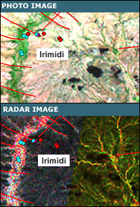
Comparing the optical and the radar images of the area around Iridimi refugee camp in Chad illustrates the potential.
The photograph shows the wadi, or dry river bed, on the left of the picture, with red dots showing dry wells and blue dots the productive wells.
Red lines are the fractures, which could hold water.
There is no real way of knowing why some wells provide water while others are dry. But the radar image is clear.
The black areas are dry, while the bright areas have the potential to hold water.
The three red dots, indicating dry wells are in the black and therefore dry area, while the blue dots are on the bright areas or on a fracture.
BBC
This is good news for all countries suffering from a lack of bores, because they hopefully won't be looking for a "needle in a haystack" for too much longer.
Sanc'.
new topics
-
whistleblower Captain Bill Uhouse on the Kingman UFO recovery
Aliens and UFOs: 3 hours ago -
1980s Arcade
General Chit Chat: 5 hours ago -
Deadpool and Wolverine
Movies: 6 hours ago -
Teenager makes chess history becoming the youngest challenger for the world championship crown
Other Current Events: 7 hours ago -
CIA botched its handling of sexual assault allegations, House intel report says
Breaking Alternative News: 8 hours ago -
Lawsuit Seeks to ‘Ban the Jab’ in Florida
Diseases and Pandemics: 10 hours ago
0