It looks like you're using an Ad Blocker.
Please white-list or disable AboveTopSecret.com in your ad-blocking tool.
Thank you.
Some features of ATS will be disabled while you continue to use an ad-blocker.

Hurricane Laura - Rapid Intensification - Half a million people ordered to evacuate
page: 2share:
a reply to: LookingForABetterLife
How's it looking? Are you still in the path?
You should get out of there if so.
Be careful and stay safe.
How's it looking? Are you still in the path?
You should get out of there if so.
Be careful and stay safe.
originally posted by: LookingAtMars
a reply to: LSU2018
The long term models are wrong a lot of the time.
Hope it misses her by miles and that you stay safe too.
Thanks. I just warned her, again, about how dangerous this will be and she said everything is tied down and extra generators have been bought. Friday, I'll post pics of damage done here, if any.
a reply to: Cancerwarrior
Hope you fare well, fortunately on the weak side and fairly far from the center, so it shouldn't be much more than the intense thunderstorms we get here on occasion.
Stay safe.
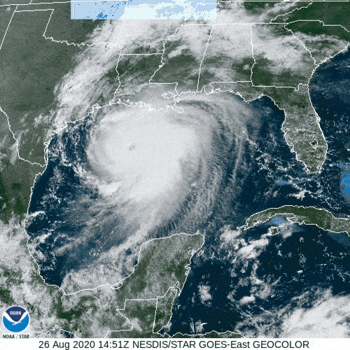
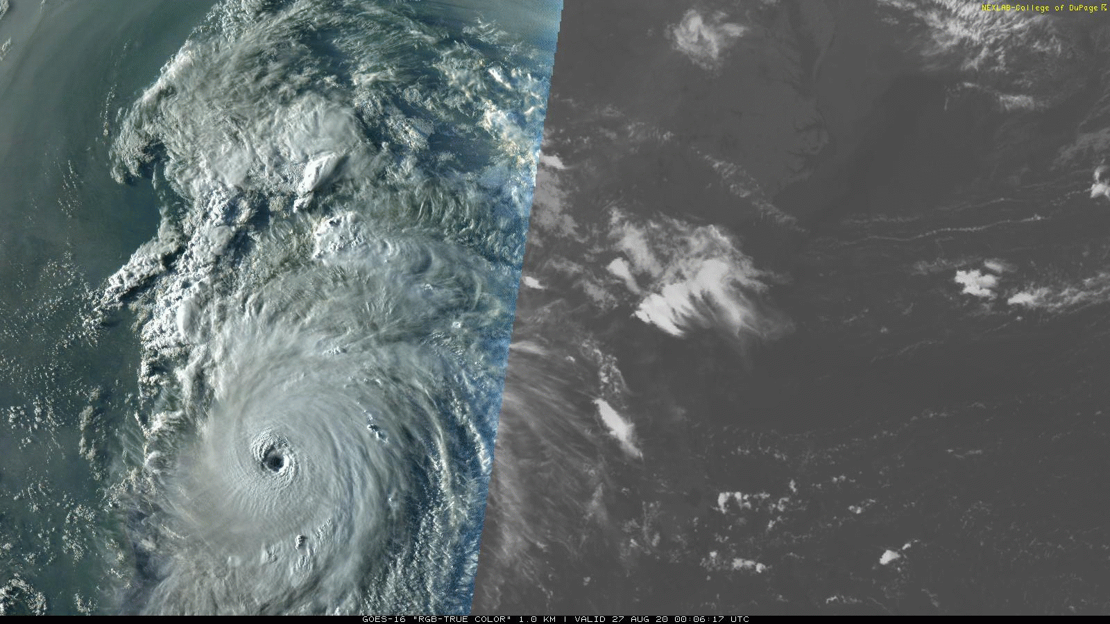
Gulf of Mexico GOES floater imagery
a reply to: LookingAtMars
And
musicismagic
And
Aallanon
And
ketsuko
Thank you all! As I mentioned above, it looks like the track is taking it fairly far east of me so I won't be in the significant damage zone, but it looks like other members are.
From a fellow resident of hurricane country, stay safe all!
Hope you fare well, fortunately on the weak side and fairly far from the center, so it shouldn't be much more than the intense thunderstorms we get here on occasion.
Stay safe.
Gulf of Mexico GOES floater imagery
a reply to: LookingAtMars
And
musicismagic
And
Aallanon
And
ketsuko
Thank you all! As I mentioned above, it looks like the track is taking it fairly far east of me so I won't be in the significant damage zone, but it looks like other members are.
From a fellow resident of hurricane country, stay safe all!
edit on 26-8-2020 by jadedANDcynical because: Replies to other posters
Local weather guy spent some time doing hurricane casting in Florida, so he keeps a blog on these things among other weather curiosities.
He thinks there might be enough sheer to keep the storm from going beyond Cat 4 and might back it down to Cat 3, but it won't happen in time to make any difference for the storm surge which will be very, very bad. He's thinking the last storm that was close to this one was Rita in terms of track and intensity.
He thinks there might be enough sheer to keep the storm from going beyond Cat 4 and might back it down to Cat 3, but it won't happen in time to make any difference for the storm surge which will be very, very bad. He's thinking the last storm that was close to this one was Rita in terms of track and intensity.
More Live Feeds
Live Coverage of Hurricane Laura from Galveston, TX.
Live From Lake Charles, LA
Live Coverage of Hurricane Laura from Kemah, TX.
Live Coverage of Hurricane Laura from Surfside, TX.
Live Storm Cam Streaming Fishing Boats Railroad Galveston Bay Texas
Hurricane Laura Live Stream - Camp Melancon
Live - Laura landfall from Lake Charles, LA
Live - Hurricane Laura from Delcambre, LA 29.94N, 91.96W
A few more live feeds.
Some have to be watched on YT's website.
When it hits I am sure we will lose some of the feeds.
edit on 26-8-2020 by LookingAtMars because: (no reason given)
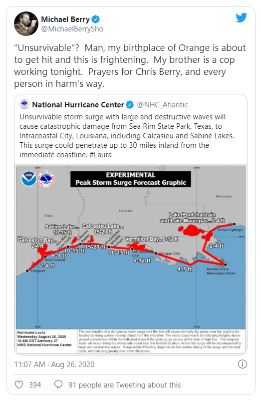
GALVESTON, Texas (AP) — Laura rapidly gained strength Wednesday, raising fears that it could come ashore as a Category 4 hurricane with a 20-foot storm surge that forecasters said would be "unsurvivable” and capable of sinking entire communities. Authorities implored coastal residents of Texas and Louisiana to flee.
The storm grew nearly 70% in power in just 24 hours to reach Category 3 status, and it continued to draw energy from the warm Gulf of Mexico waters. The system was on track to arrive late Wednesday or early Thursday as the most powerful hurricane to strike the U.S. so far this year.
“This is shaping up to be just a tremendous storm,” Louisiana Gov. John Bel Edwards told The Weather Channel.
Laura gains power, could come ashore as Category 4 hurricane
Looking at the live feeds, rain and wind are hitting the coast hard now in some places.
The storm has not even hit land yet. Over 130mph winds and up to a 20-foot storm surge is expected when it makes landfall.

edit on 26-8-2020 by LookingAtMars because: (no reason given)
NHC
warns of 15-20ft storm surge along TX-LA Gulf Coast. They are labeling it "unsurvivable" if you happen to be in those areas and saying it could
penetrate as far inland as 30 miles.
Please get out if you are in one of those areas. Someone here mentioned having a loved on in Orange? It's right in the line of this thing.
Please get out if you are in one of those areas. Someone here mentioned having a loved on in Orange? It's right in the line of this thing.
edit on 26-8-2020 by ketsuko because: (no reason given)
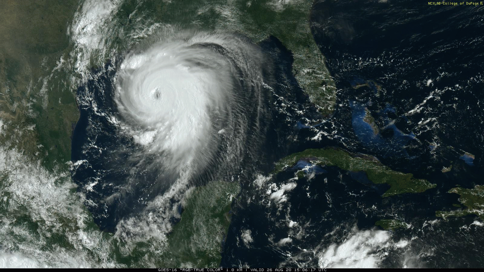
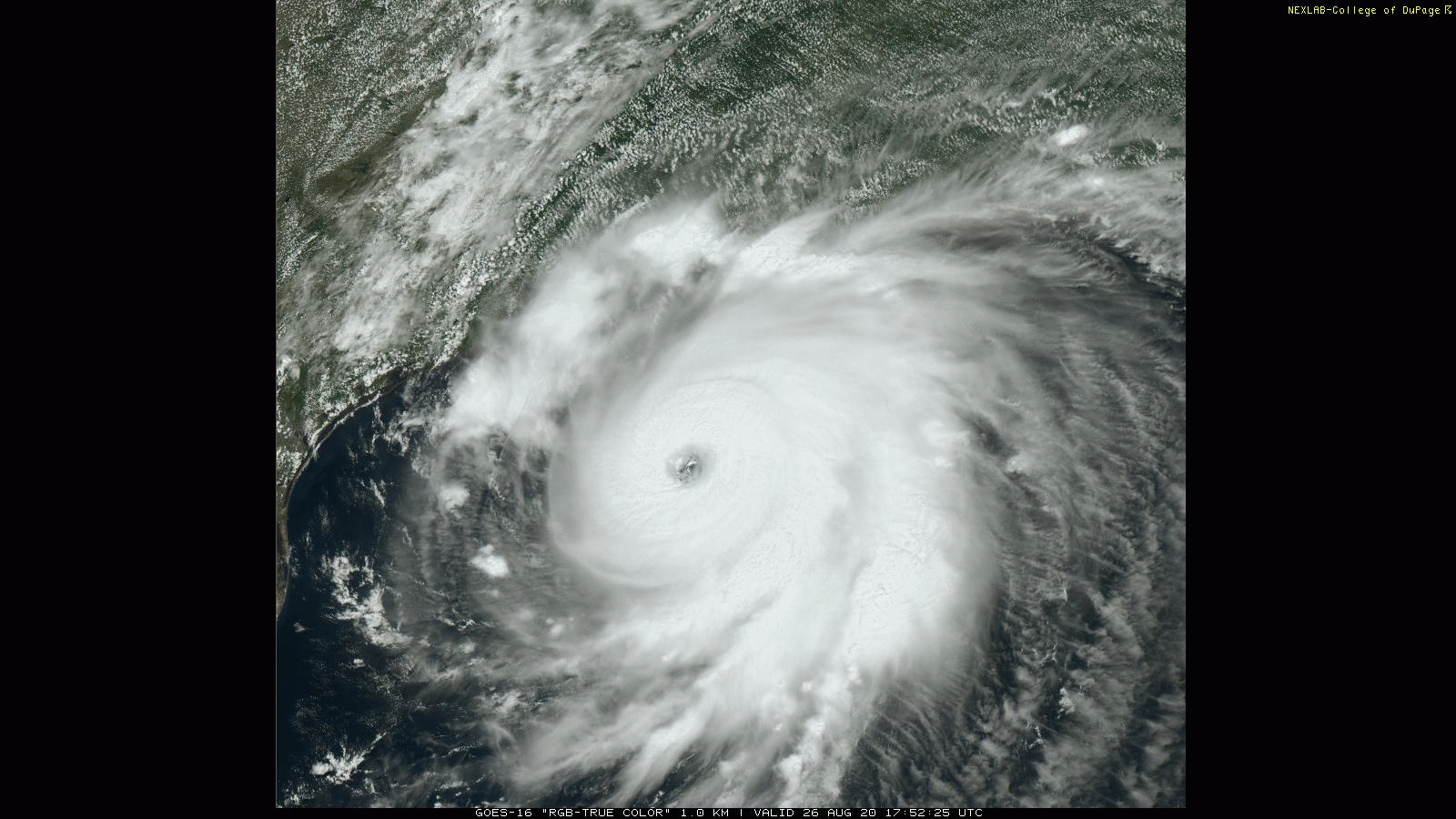
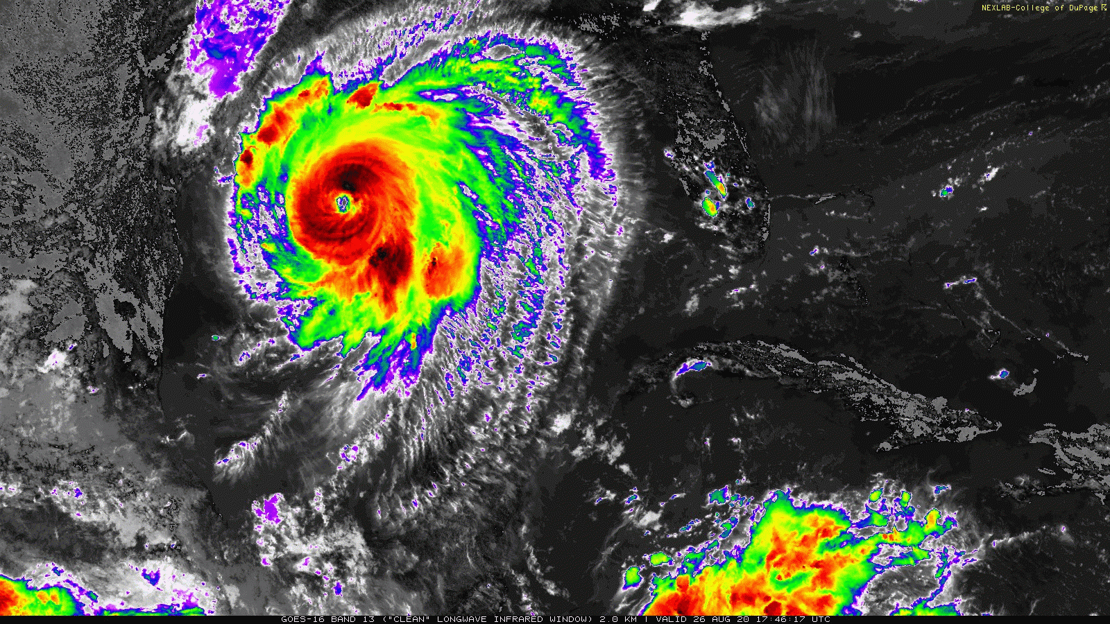
Laura is now Category 4, 'unsurvivable storm surge' expected
Anyone in the path needs to get out now. Convince love ones to get out now. This may end up worst than Katrina.
As has been posted, this storm is not survivable. Find shelter on high ground now!
"Unsurvivable storm surge with large and destructive waves will cause catastrophic damage from Sea Rim State Park, Texas, to Intracoastal City, Louisiana, including Calcasieu and Sabine Lakes," the NWS said in a statement. "This surge could penetrate up to 30 miles inland from the immediate coastline. Only a few hours remain to protect life and property and all actions should be rushed to completion."
Parts of eastern Texas and western Louisiana are forecast to see "catastrophic wind damage," especially in places where the storm's eyewall makes landfall, the NWS said. Residents are urged to brace for "widespread damaging wind gusts" that will spread well inland across parts of those areas early Thursday morning.
Anyone in the path needs to get out now. Convince love ones to get out now. This may end up worst than Katrina.
As has been posted, this storm is not survivable. Find shelter on high ground now!
edit on 26-8-2020 by LookingAtMars because: (no reason given)
Still see people walking and driving around on those live feeds. Look like one guy was surfboarding.
Crazy...
Crazy...
a reply to: ketsuko
That was me. I've tried to get my Aunt to leave but she refuses. I don't think she understands how bad this is going to get, especially right there in Orange. She's only about 20 miles from the Gulf and right at Sabine Lake. I wish my Uncle was alive, he'd force her to leave.
That was me. I've tried to get my Aunt to leave but she refuses. I don't think she understands how bad this is going to get, especially right there in Orange. She's only about 20 miles from the Gulf and right at Sabine Lake. I wish my Uncle was alive, he'd force her to leave.
originally posted by: LSU2018
a reply to: ketsuko
That was me. I've tried to get my Aunt to leave but she refuses. I don't think she understands how bad this is going to get, especially right there in Orange. She's only about 20 miles from the Gulf and right at Sabine Lake. I wish my Uncle was alive, he'd force her to leave.
Oh my, you have my thoughts and prayers and so does she. Is there no one who can get her out of there?
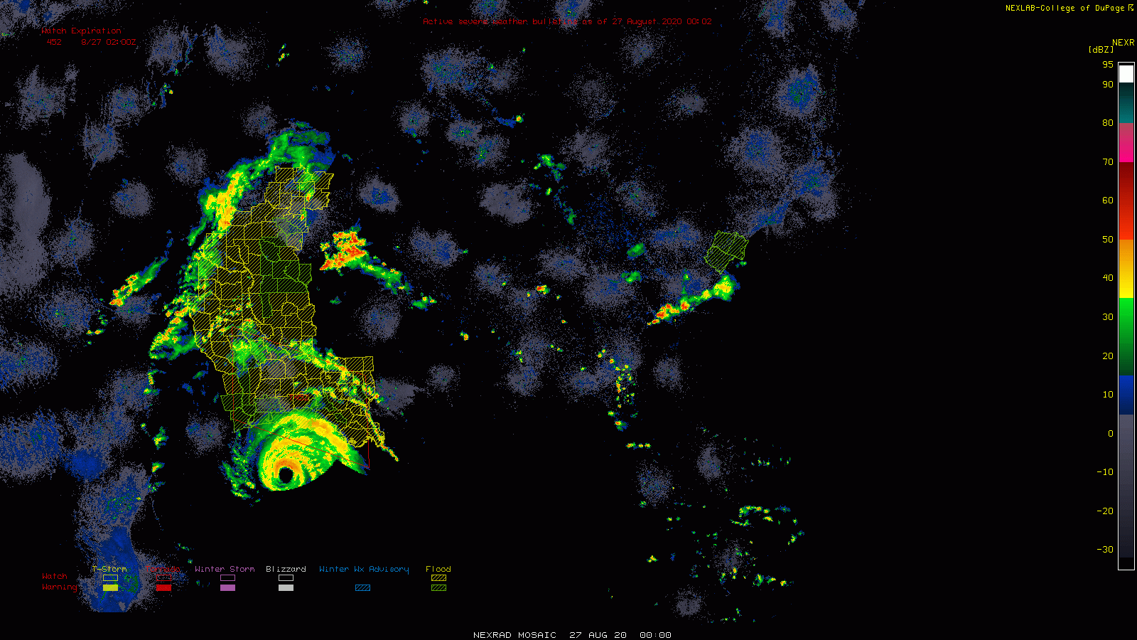
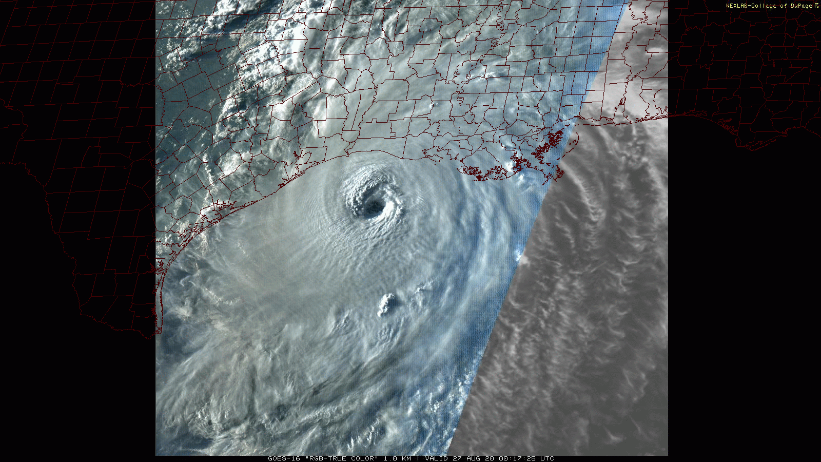
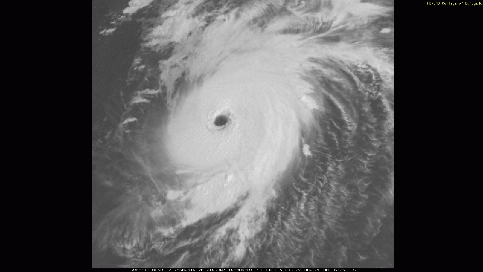
Laura is close enough to the shore to be picked up on ground radar.
The only good news I see in this is that it sounds like a lot of people are evacuating.
Hurricane Laura’s maximum sustained winds “have increased to near 150 mph,” according to the latest advisory by the National Weather Service’s National Hurricane Center.
The Category 4 storm could strengthen further before making landfall near the Texas-Louisiana border, according to the advisory.
Hurricane Laura updates: News and live hurricane path tracker
San Antonio had expected 300 evacuees Tuesday night but 1,400 arrived by the end of the night, said Joe Arrington, San Antonio Fire Department spokesman. By 5 p.m. Wednesday, 2,103 had come to the help center to get hotel accommodations assigned to them.
The only good news I see in this is that it sounds like a lot of people are evacuating.
edit on 26-8-2020 by LookingAtMars because: (no reason given)
Water levels. Realtime, more or less.
tidesandcurrents.noaa.gov...
tidesandcurrents.noaa.gov...
edit on 8/26/2020 by Phage because: (no reason given)
edit on
8/26/2020 by Phage because: (no reason given)
Pretty crazy here at the moment. I’ve got limbs down everywhere. Pine tree fell in the yard and ripped the junction box off the side of the house.
The cleanup from this is gonna take a long while and the bad weather is still south of where I’m at.
This is going to be bad for what’s already a pretty poor state. Stay safe frens
This is going to be bad for what’s already a pretty poor state. Stay safe frens
a reply to: LookingAtMars
My brother-in-law is a research meteorologist (as opposed to a TV weatherman) who's spent a lot of time flying around in those hurricane hunter airplanes. He's done a lot of work for NASA over the years.
Personally, I think he's nuts, but my sister loves him, so we all nod approvingly.
In any event, he doesn't often get hyperbolic when it comes to discussing potential hurricanes, etc.
I asked him what he thought of this one a few days ago and he said "This one is going to be a monster".
From him, that's a very dire warning.
I hope people in that area listened when told to evacuate or take cover.
If you are in the area evacuate! I think this is going to be a very powerful storm.
Hurricane Laura has started to rotate and an eye is developing.
The sea level will rise at least 10 feet. That will flood many miles of inland.
Something else that is rare about Laura is that it has tremendous electrical energy.
My brother-in-law is a research meteorologist (as opposed to a TV weatherman) who's spent a lot of time flying around in those hurricane hunter airplanes. He's done a lot of work for NASA over the years.
Personally, I think he's nuts, but my sister loves him, so we all nod approvingly.
In any event, he doesn't often get hyperbolic when it comes to discussing potential hurricanes, etc.
I asked him what he thought of this one a few days ago and he said "This one is going to be a monster".
From him, that's a very dire warning.
I hope people in that area listened when told to evacuate or take cover.
edit on 8/27/2020 by Riffrafter because: (no reason given)
The storm missed me so nothing bad to report. My heart goes out to all those who have lost family, friends, pets, and property.
Calcasieu Pass, LA
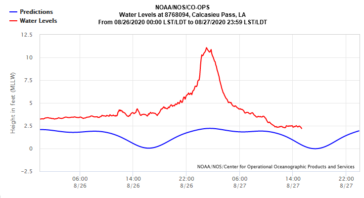
Looks like "normal" tides have been running about 1' above the prediction, so call it an 8' storm surge at this tide station.
Looks like "normal" tides have been running about 1' above the prediction, so call it an 8' storm surge at this tide station.
edit on 8/27/2020 by Phage because: (no reason given)
originally posted by: ketsuko
originally posted by: LSU2018
a reply to: ketsuko
That was me. I've tried to get my Aunt to leave but she refuses. I don't think she understands how bad this is going to get, especially right there in Orange. She's only about 20 miles from the Gulf and right at Sabine Lake. I wish my Uncle was alive, he'd force her to leave.
Oh my, you have my thoughts and prayers and so does she. Is there no one who can get her out of there?
Thank you, all my family is safe. She refused to evacuate but has since told us she's fine. They lost one of their big barns but everything else is ok. Up here where I'm at, there are lots of limbs down and if you step outside, you hear generators all over the place. My wife and I tried to find one Wednesday but when we called any business that sold them, they answered (I'll use Tractor Supply as an example), "Tractor Supply, we're out of generators". Yesterday around 2 pm we called Lowe's and I asked the guy when their next shipment was coming in. He said we just got it in but they're going fast.
We went there immediately and there were probably 60 cars at the Lumber Pickup. I parked, went inside and asked where the gens were. The man I asked said "You're looking at them". I says to him, where are the other options and he says that's all they got in. So we bought a 7500 for $940.00 after tax and 2 more gas cans. They started with 170 and within 4 hours were down to just 31 left.
Living in a small town, we're always the last to get power so the purchase was a needed one. There are 3 trees down across power lines, but here's the one effecting us.
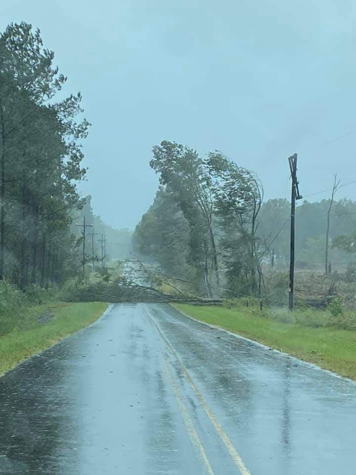
There's also another line down near our house but I didn't see a tree laying on it.
new topics
-
God's Righteousness is Greater than Our Wrath
Religion, Faith, And Theology: 17 minutes ago -
Electrical tricks for saving money
Education and Media: 3 hours ago -
VP's Secret Service agent brawls with other agents at Andrews
Mainstream News: 4 hours ago -
Sunak spinning the sickness figures
Other Current Events: 5 hours ago -
Nearly 70% Of Americans Want Talks To End War In Ukraine
Political Issues: 5 hours ago -
Late Night with the Devil - a really good unusual modern horror film.
Movies: 7 hours ago -
Cats Used as Live Bait to Train Ferocious Pitbulls in Illegal NYC Dogfighting
Social Issues and Civil Unrest: 8 hours ago -
The Good News According to Jesus - Episode 1
Religion, Faith, And Theology: 10 hours ago
top topics
-
Florida man's trip overseas ends in shock over $143,000 T-Mobile phone bill
Social Issues and Civil Unrest: 15 hours ago, 8 flags -
Cats Used as Live Bait to Train Ferocious Pitbulls in Illegal NYC Dogfighting
Social Issues and Civil Unrest: 8 hours ago, 8 flags -
VP's Secret Service agent brawls with other agents at Andrews
Mainstream News: 4 hours ago, 8 flags -
Former Labour minister Frank Field dies aged 81
People: 17 hours ago, 4 flags -
Bobiverse
Fantasy & Science Fiction: 15 hours ago, 3 flags -
HORRIBLE !! Russian Soldier Drinking Own Urine To Survive In Battle
World War Three: 12 hours ago, 3 flags -
Electrical tricks for saving money
Education and Media: 3 hours ago, 3 flags -
Nearly 70% Of Americans Want Talks To End War In Ukraine
Political Issues: 5 hours ago, 3 flags -
Sunak spinning the sickness figures
Other Current Events: 5 hours ago, 3 flags -
Late Night with the Devil - a really good unusual modern horror film.
Movies: 7 hours ago, 2 flags
active topics
-
HORRIBLE !! Russian Soldier Drinking Own Urine To Survive In Battle
World War Three • 31 • : budzprime69 -
How ageing is" immune deficiency"
Medical Issues & Conspiracies • 33 • : rickymouse -
VP's Secret Service agent brawls with other agents at Andrews
Mainstream News • 32 • : ThatSmellsStrange -
The Reality of the Laser
Military Projects • 46 • : Zaphod58 -
God's Righteousness is Greater than Our Wrath
Religion, Faith, And Theology • 0 • : randomuser2034 -
President BIDEN Vows to Make Americans Pay More Federal Taxes in 2025 - Political Suicide.
2024 Elections • 136 • : ImagoDei -
Electrical tricks for saving money
Education and Media • 3 • : Mike72 -
TLDR post about ATS and why I love it and hope we all stay together somewhere
General Chit Chat • 10 • : theshadowknows -
Why to avoid TikTok
Education and Media • 20 • : 5thHead -
-@TH3WH17ERABB17- -Q- ---TIME TO SHOW THE WORLD--- -Part- --44--
Dissecting Disinformation • 657 • : daskakik