It looks like you're using an Ad Blocker.
Please white-list or disable AboveTopSecret.com in your ad-blocking tool.
Thank you.
Some features of ATS will be disabled while you continue to use an ad-blocker.

S4 now listed on KXTA Homey Airport chart?
page: 16
share:
I was checking out some charts on a popular pilot/aviation website, and came across this great chart of Groom Lake (Homey Airport)
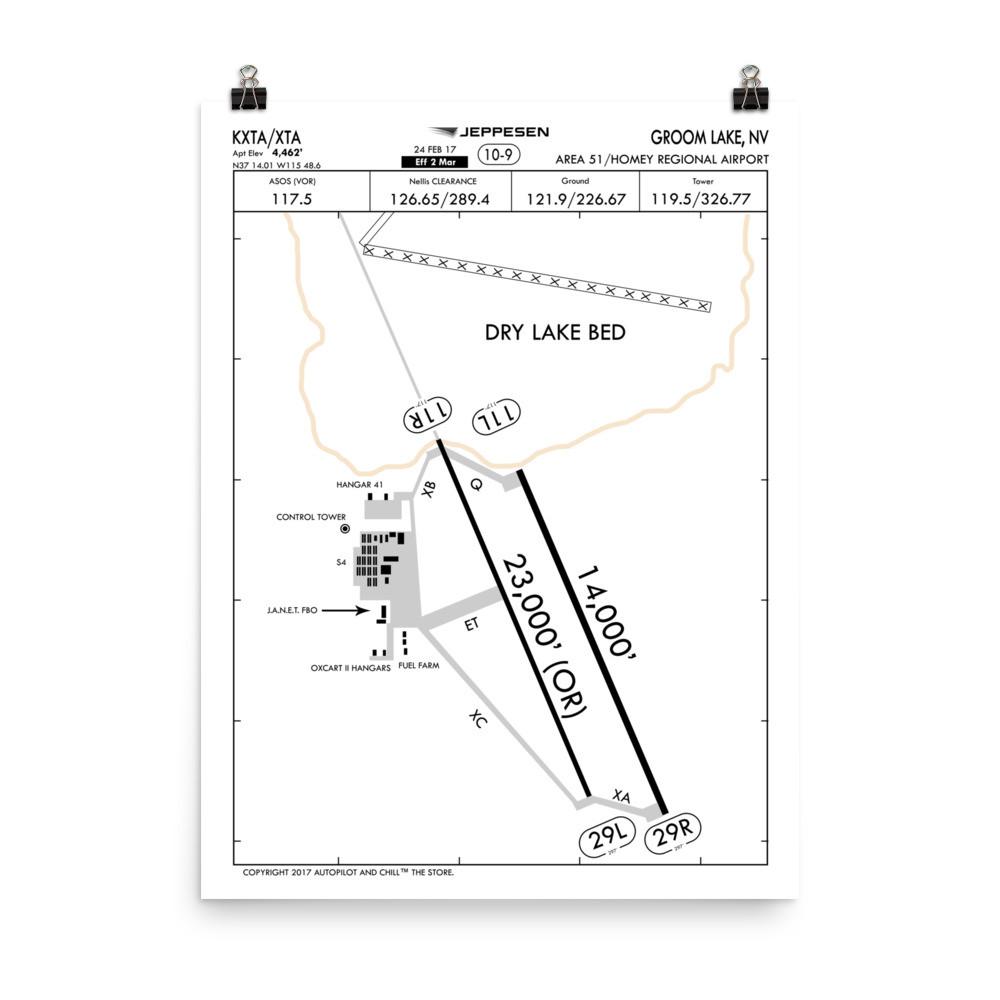
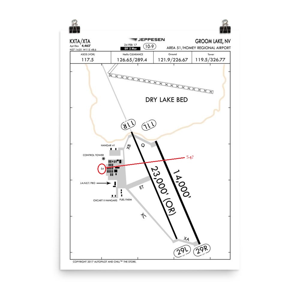
Highlighted the area that jumped out at me..
Sure, somebody who designs these charts could be having a chuckle. Just wondering if any other chart lists this (or other) designations, or if this was a one-off joke
Here is the original site selling the map (you don't have to buy it to view the sample map)
www.autopilotandchill.com...
edit on 9/29/2019 by JBurns because: (no
reason given)
We all know Homey don't play that chit...
They named it Homey....really. great comedy....no....that place is serious....so the pilots get clearance from the center.....CLEARED DIRECT, HOMEY!! He he
They named it Homey....really. great comedy....no....that place is serious....so the pilots get clearance from the center.....CLEARED DIRECT, HOMEY!! He he
a reply to: GBP/JPY
I wondered if this was how they pronounced it, "Home-E" or "Home-Why"
Figured it might be like "Slatter Lake" and named after somebody well known among the base workers
This "S-4" stuff is unusual though, if official in any way it represents no less than two confirmed locations/buildings/sites bearing the same name as Lazar's Papoose lake facility. It may not prove anything, but makes one question "Why" not to mention how Lazar would know about any facility called "S-4"
Always interested me also that the Manhattan project was referred to as "S-1" during its time. Just a thought, but the Teller connection again comes to mind
a reply to: JBurns
Good one.
Your source:
www.autopilotandchill.com...
Good one.
Your source:
Area 51 Airport Facility Diagram Poster
Regular price $21.50
Some how we got out hands on the most coveted Airport Facility Diagram of aviation. Really this is so top-secret we don't recommend hanging it in a place for others to see. It could be confiscated by the feds too. Realistically, we stole the from Russian and Chinese spies. The fight was intense, something out of a James Bond movie, but we prevailed and now have it to offer for sale right here at Autopilot And Chill™ The Store. This print is officially scaled and drawn to FAA NACO specs.
www.autopilotandchill.com...
edit on 9/30/2019 by Phage because: (no reason given)
Heh.
www.autopilotandchill.com...
www.autopilotandchill.com...
www.autopilotandchill.com...
www.autopilotandchill.com...
edit on 9/30/2019 by Phage because: (no reason
given)
a reply to: ignorant_ape
Yeah, what's with the bogus runway headings? It should be runway 14-32 (L and R).
Yeah, what's with the bogus runway headings? It should be runway 14-32 (L and R).
Note that they don't show the two vertical runways starting from the Oxcart hangar doors.
originally posted by: Phage
a reply to: pteridine
Hint.
It's a joke.
www.abovetopsecret.com...
Hint.
So are vertical runways.
New to this site and for some reason cannot create a thread, but this is perhaps related to s-4. I have seen photos of this site before, but does
anyone know its purpose or use? It's use appears to have increased over time based on density and thickness of the road shown in sat images over the
years. Location north west of Papoose Lake. It lies in a valley and is adjoined by mountains on nearly all sides at close proximity. It is very
hard to see on older images but dates to the 1980's as it is visible.
37° 9'32.95"N 115°55'39.41"W
www.google.com...@37.1591544,-115.9275376,311m/data=!3m1!1e3
www.google.com...@37.1632398,-115.8765329,17905m/data=!3m1!1e3
37° 9'32.95"N 115°55'39.41"W
www.google.com...@37.1591544,-115.9275376,311m/data=!3m1!1e3
www.google.com...@37.1632398,-115.8765329,17905m/data=!3m1!1e3
new topics
-
Weinstein's conviction overturned
Mainstream News: 1 hours ago -
Supreme Court Oral Arguments 4.25.2024 - Are PRESIDENTS IMMUNE From Later Being Prosecuted.
Above Politics: 2 hours ago -
Krystalnacht on today's most elite Universities?
Social Issues and Civil Unrest: 2 hours ago -
Chris Christie Wishes Death Upon Trump and Ramaswamy
Politicians & People: 3 hours ago -
University of Texas Instantly Shuts Down Anti Israel Protests
Education and Media: 5 hours ago -
Any one suspicious of fever promotions events, major investor Goldman Sachs card only.
The Gray Area: 7 hours ago
top topics
-
VP's Secret Service agent brawls with other agents at Andrews
Mainstream News: 16 hours ago, 11 flags -
Krystalnacht on today's most elite Universities?
Social Issues and Civil Unrest: 2 hours ago, 7 flags -
Nearly 70% Of Americans Want Talks To End War In Ukraine
Political Issues: 17 hours ago, 6 flags -
Supreme Court Oral Arguments 4.25.2024 - Are PRESIDENTS IMMUNE From Later Being Prosecuted.
Above Politics: 2 hours ago, 5 flags -
Weinstein's conviction overturned
Mainstream News: 1 hours ago, 5 flags -
Electrical tricks for saving money
Education and Media: 15 hours ago, 5 flags -
Sunak spinning the sickness figures
Other Current Events: 17 hours ago, 5 flags -
University of Texas Instantly Shuts Down Anti Israel Protests
Education and Media: 5 hours ago, 3 flags -
Any one suspicious of fever promotions events, major investor Goldman Sachs card only.
The Gray Area: 7 hours ago, 2 flags -
God's Righteousness is Greater than Our Wrath
Religion, Faith, And Theology: 12 hours ago, 1 flags
active topics
-
Candidate TRUMP Now Has Crazy Judge JUAN MERCHAN After Him - The Stormy Daniels Hush-Money Case.
Political Conspiracies • 748 • : Justoneman -
God's Righteousness is Greater than Our Wrath
Religion, Faith, And Theology • 26 • : CristianVictoria -
Weinstein's conviction overturned
Mainstream News • 12 • : CristianVictoria -
University of Texas Instantly Shuts Down Anti Israel Protests
Education and Media • 106 • : DBCowboy -
Nearly 70% Of Americans Want Talks To End War In Ukraine
Political Issues • 82 • : gortex -
Supreme Court Oral Arguments 4.25.2024 - Are PRESIDENTS IMMUNE From Later Being Prosecuted.
Above Politics • 39 • : xuenchen -
Chris Christie Wishes Death Upon Trump and Ramaswamy
Politicians & People • 13 • : mysterioustranger -
"We're All Hamas" Heard at Columbia University Protests
Social Issues and Civil Unrest • 283 • : FlyersFan -
Biden--My Uncle Was Eaten By Cannibals
US Political Madness • 73 • : CarlLaFong -
-@TH3WH17ERABB17- -Q- ---TIME TO SHOW THE WORLD--- -Part- --44--
Dissecting Disinformation • 671 • : daskakik
6