It looks like you're using an Ad Blocker.
Please white-list or disable AboveTopSecret.com in your ad-blocking tool.
Thank you.
Some features of ATS will be disabled while you continue to use an ad-blocker.

I have a bad feeling about Dorian
page: 14
share:
I was checking the expected path of Dorian today and also comparing with Sandy's path.
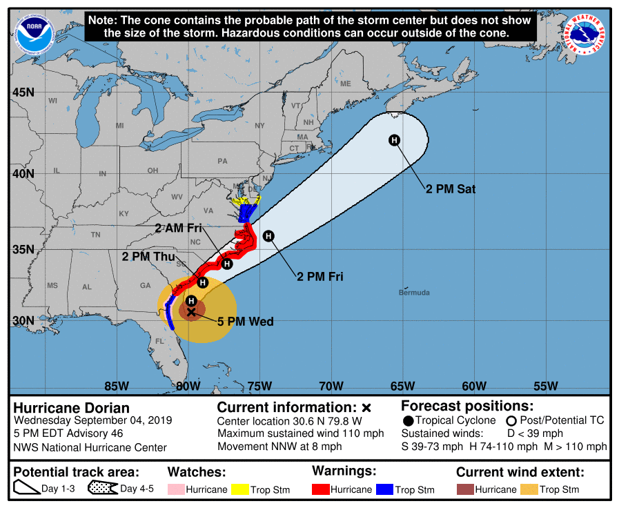
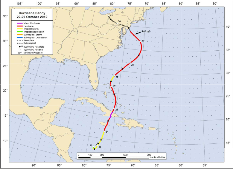
Dorian will be near NJ about Friday. I wonder what are the chances that it could make a turn and hit us like Sandy.
I was reading an article from nj.com with a title "Hurricane Dorian update: Storm tracks dangerously close to East Coast". We'll have a lot of rain for sure. Today is very hot here and we are under a severe thunderstorm watch for most of the areas of NJ.
Told wife to get the groceries tomorrow, just in case.
edit on 4-9-2019 by Trueman because: (no reason given)
I'm in South Jersey across the bridge from Philadelphia.
Personally based on the track as is I don't think we are going to feel anything but those down the shore may.
Personally based on the track as is I don't think we are going to feel anything but those down the shore may.
originally posted by: opethPA
I'm in South Jersey across the bridge from Philadelphia.
Personally based on the track as is I don't think we are going to feel anything but those down the shore may.
I really hope the same but it's good to be alert too. You know, these things never follow orders.
Well that's disappointing I hope you are safe I thought the news was that it was finally going to somehow get to Alabama

originally posted by: Trueman
originally posted by: SeaWorthy
a reply to: Trueman
You know, these things never follow orders.
That is likely untrue now days.
Prove it. Order Dorian to go back.
blogs.scientificamerican.com...
Here's how Hoffman described what he found in a simulation of the Hurricane Iniki, a 1992 storm that was the most powerful ever to hit the Hawaiian islands: The most significant modifications proved to be in the starting temperatures and winds.
Typical temperature adjustments across the grid were mere tenths of a degree, but the most notable change—an increase of nearly two degrees Celsius—occurred in the lowest model layer west of the storm center. The calculations yielded wind-speed alterations of two or three miles per hour. In a few locations, though, the velocities changed by as much as 20 mph because of minor redirections of the winds near the storm’s center.
Although the original and altered versions of Hurricane Iniki looked nearly identical in structure, the changes in the key variables were large enough that the latter veered off to the west for the first six hours of the simulation and then traveled due north, so that Kauai escaped the storm’s most damaging winds.
The relatively small, artificial alterations to the storm’s initial conditions had propagated through the complex set of nonlinear equations that simulated the storm to result in the desired relocation after six hours. This run gave us confidence that we were on the right path to determining the changes needed to modify real hurricanes.
originally posted by: Trueman
originally posted by: SeaWorthy
a reply to: Trueman
You know, these things never follow orders.
That is likely untrue now days.
Prove it. Order Dorian to go back.
2017
Scientist close to being able to steer huricanes
"In the wake of Katrina, two rival teams of climate scientists are working on ways to steer hurricanes, so as to be able to avoid direct hits on major cities in the future. Both teams are using the technique of removing power and speed from strategic points in the hurricane, effectively refracting its path.
The American team is approaching this by warming the areas of the tops of the hurricane clouds, either by dropping ash to absorb heat from the sun, or directly beaming microwaves on those areas from space. The Israeli team is taking the approach of cooling the bottom of the hurricane by releasing dust along its base.
The concern is raised of lawsuits from the small towns that hurricanes are directed towards in the effort to avoid large cities. But if the space-based solution could be done efficiently, and applied to all large tropical storms, couldn't we one day send them all harmlessly into the North Atlantic?"
science.slashdot.org...
a reply to: SeaWorthy
Our land is supposed to be hit by these storms, that is just the process of the planet. Europe usually will get the vestiges of the storm systems that dissipate in the Atlantic.
This is why apocalyptic wildfire occur as well, human modifications prevent the regular occurrence of smaller wild fires.
Our land is supposed to be hit by these storms, that is just the process of the planet. Europe usually will get the vestiges of the storm systems that dissipate in the Atlantic.
This is why apocalyptic wildfire occur as well, human modifications prevent the regular occurrence of smaller wild fires.
originally posted by: Willtell
a reply to: Trueman
Hey, my fellow Jersian please don't put a hex on us.
I remember Sandy..No gas...stores were empty... pretty ugly and I don't live near any beaches
Oh man, how can I forget that. It was almost like a Carrington event.
edit on 5-9-2019 by Trueman because: (no reason given)
Dorian will not hook left to hit the Jersey area. The steering currents will.not let it happen. Dorian will be accelerating to the northeast while
transitioning to an extra-tropical low.
originally posted by: jrod
Dorian will not hook left to hit the Jersey area. The steering currents will.not let it happen. Dorian will be accelerating to the northeast while transitioning to an extra-tropical low.
Just reading it went up to cat 2 again and moving slow, 8 mph. Steering winds are our hope.
Actually, it's cat 3 now.
edit on 5-9-2019 by Trueman because: (no reason given)
new topics
-
In an Historic First, In N Out Burger Permanently Closes a Location
Mainstream News: 1 hours ago -
MH370 Again....
Disaster Conspiracies: 1 hours ago -
Are you ready for the return of Jesus Christ? Have you been cleansed by His blood?
Religion, Faith, And Theology: 3 hours ago -
Chronological time line of open source information
History: 5 hours ago -
A man of the people
Diseases and Pandemics: 6 hours ago -
Ramblings on DNA, blood, and Spirit.
Philosophy and Metaphysics: 6 hours ago -
4 plans of US elites to defeat Russia
New World Order: 8 hours ago -
Thousands Of Young Ukrainian Men Trying To Flee The Country To Avoid Conscription And The War
Other Current Events: 11 hours ago
top topics
-
Israeli Missile Strikes in Iran, Explosions in Syria + Iraq
World War Three: 15 hours ago, 17 flags -
In an Historic First, In N Out Burger Permanently Closes a Location
Mainstream News: 1 hours ago, 10 flags -
Thousands Of Young Ukrainian Men Trying To Flee The Country To Avoid Conscription And The War
Other Current Events: 11 hours ago, 7 flags -
Iran launches Retalliation Strike 4.18.24
World War Three: 14 hours ago, 6 flags -
12 jurors selected in Trump criminal trial
US Political Madness: 14 hours ago, 4 flags -
4 plans of US elites to defeat Russia
New World Order: 8 hours ago, 4 flags -
A man of the people
Diseases and Pandemics: 6 hours ago, 4 flags -
Chronological time line of open source information
History: 5 hours ago, 2 flags -
Are you ready for the return of Jesus Christ? Have you been cleansed by His blood?
Religion, Faith, And Theology: 3 hours ago, 2 flags -
MH370 Again....
Disaster Conspiracies: 1 hours ago, 1 flags
active topics
-
Thousands Of Young Ukrainian Men Trying To Flee The Country To Avoid Conscription And The War
Other Current Events • 22 • : Xtrozero -
12 jurors selected in Trump criminal trial
US Political Madness • 46 • : iaylyan -
Fossils in Greece Suggest Human Ancestors Evolved in Europe, Not Africa
Origins and Creationism • 69 • : Xtrozero -
4 plans of US elites to defeat Russia
New World Order • 31 • : andy06shake -
In an Historic First, In N Out Burger Permanently Closes a Location
Mainstream News • 3 • : Bluntone22 -
George Knapp AMA on DI
Area 51 and other Facilities • 24 • : Raptured -
Marjorie Taylor Greene Files Motion to Vacate Speaker Mike Johnson
US Political Madness • 63 • : WeMustCare -
Do we live in a simulation similar to The Matrix 1999?
ATS Skunk Works • 23 • : JoelSnape -
Are you ready for the return of Jesus Christ? Have you been cleansed by His blood?
Religion, Faith, And Theology • 13 • : Cvastar -
MH370 Again....
Disaster Conspiracies • 4 • : Vermilion
4