It looks like you're using an Ad Blocker.
Please white-list or disable AboveTopSecret.com in your ad-blocking tool.
Thank you.
Some features of ATS will be disabled while you continue to use an ad-blocker.

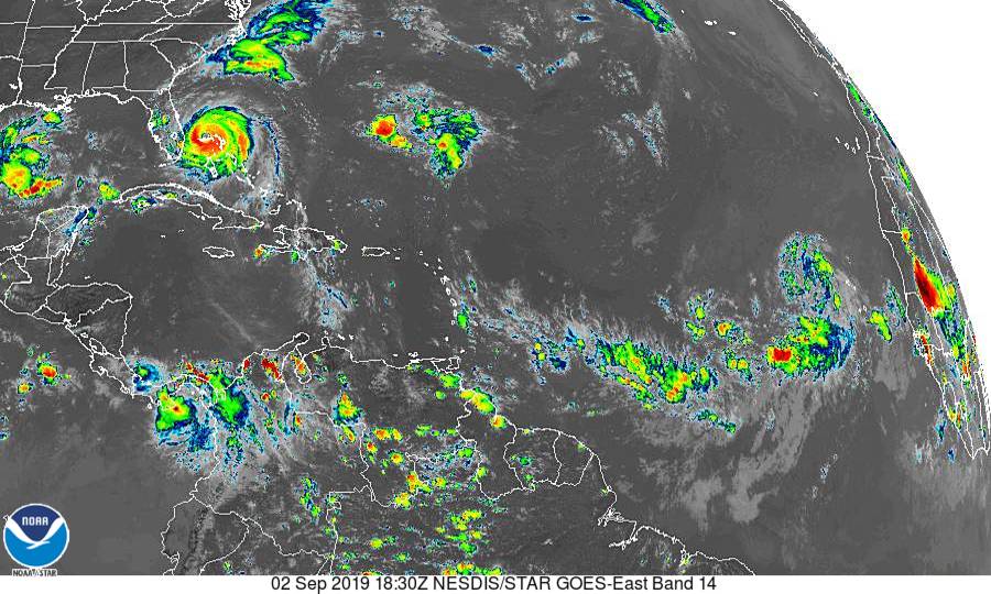
Is this Huge Storm going to be Hurricane Erin?
page: 2share:
originally posted by: Phage
Yes, most models have the low pressure system you're talking about developing into a tropical depression over the next 5 days. Some show the possibility of it turning into a tropical storm. Almost all of them have it turning north into the mid-Atlantic. Too early to tell what might happen after that.
But the extent of the low pressure area does not indicate the size of a depression, storm, or hurricane which may develop.
tropicalatlantic.com...
Awesome graphic Phage, and your correct. I corrected my above post.
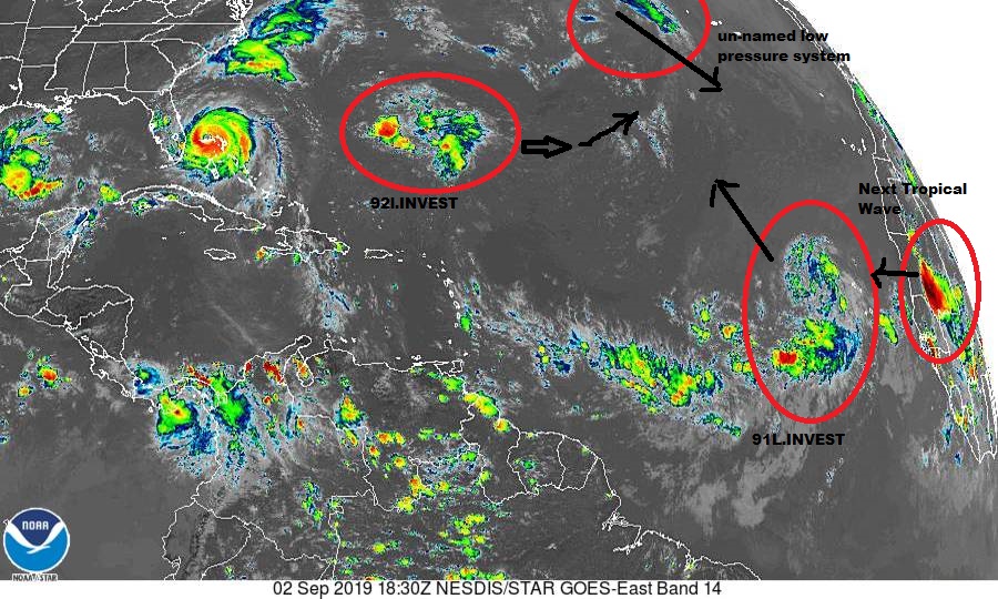
Now what do you think will happen when the HUGE low above it (which by the way is turning S by SE) joins 91L?
Please review my other thread (or is it a post?) here; www.abovetopsecret.com...
originally posted by: Flyingclaydisk
a reply to: Violater1
Don't know anything really about storms, but that time lapse link you posted is cool as hell!
Thank you
Here is another one:cdn.star.nesdis.noaa.gov...
a reply to: Violater1
It won't. It's moving east quite rapidly and losing strength, being eaten by the high pressure area. It will be gone within 72 hours.
ocean.weather.gov...
Now what do you think will happen when the HUGE low above it (which by the way is turning S by SE) joins 91L?
It won't. It's moving east quite rapidly and losing strength, being eaten by the high pressure area. It will be gone within 72 hours.
ocean.weather.gov...
edit on 9/2/2019 by Phage because: (no reason given)
a reply to: Violater1
That one is a bit far north to be a threat to the US. Those usually go straight north not hitting anyone. NOAA only gives it a 40% chance for development.
Another storm just off the cape verde coastal area which is further south has a 60% chance for development. I'd watch that one more. Thats the area where the big ones form this time of year.
a reply to: Phage
I hope your right (don't get me started :-) ).
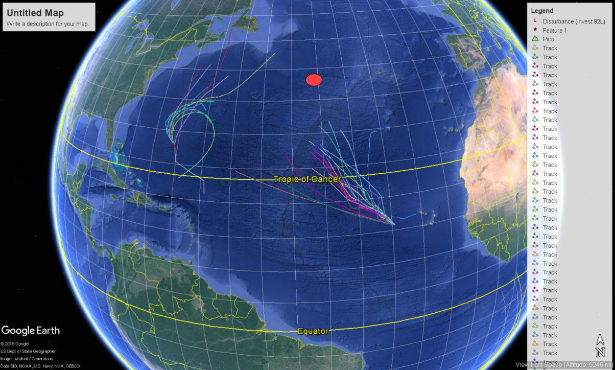
However this GEOS video (updated q 15 min) and photo show them closing in on each other.
www.star.nesdis.noaa.gov...
I hope your right (don't get me started :-) ).
However this GEOS video (updated q 15 min) and photo show them closing in on each other.
www.star.nesdis.noaa.gov...
The next name will be Fernand. Tropical stormbErin already formed and dissapated this year.
Here in the UK we tend to get the dregs of the storms and hurricanes you received, at much lower strength levels. It all depends on where the jet
stream is placed. Currently, it is right over the UK covering the whole landmass, streaming at around a 100 mile an hour west to east.
It is the jet stream that steers all your storms towards us here in Britain, so we tend to hope that the jet stream loops wildly towards extreme north, as that draws the hot weather up from the Med and Africa. The geological placement of Britain gives the land mass a unique weather situation. There are always three weather systems competing for dominance over Britain at any time, and the positioning of the jet stream tends to determine which system wins the day.
We have a east to west weather system bringing the cold air over from Siberia, we have the Atlantic system (west to east) which can bring both good and bad weather, but generally a lot of precipitation, and we also have a south to north system which brings us the good weather.
Dorian looks interesting as it may well only scratch the US coast and end up under the jet stream to be driven towards Europe and the UK?
a reply to: elysiumfire
You have cause and effect reversed. The jet streams are the result of conditions in the lower atmosphere. The northern jet stream forms where cool polar air meets warmer temperate air. It is this interface which "steers" (and forms) northern storms as well as producing the jet streams. While jet streams can transport moisture which gets taken into them, they do not cause weather. But they do make very good signposts for showing where that interface occurs.
www.weather.gov...
It is the jet stream that steers all your storms towards us here in Britain, so we tend to hope that the jet stream loops wildly towards extreme north, as that draws the hot weather up from the Med and Africa.
You have cause and effect reversed. The jet streams are the result of conditions in the lower atmosphere. The northern jet stream forms where cool polar air meets warmer temperate air. It is this interface which "steers" (and forms) northern storms as well as producing the jet streams. While jet streams can transport moisture which gets taken into them, they do not cause weather. But they do make very good signposts for showing where that interface occurs.
www.weather.gov...
From my understanding the hot air from equatorial regions rises up into the atmosphere and moves north and south, depending which side of the doldrums
the rising air is.
As you suggest, this northwards moving hot air meets with southward moving cold air and where they interface jet streams form. For the north the stream tends to move west to east, but often loops wildly and even break up and then reform, anything under the jet stream is influenced to move along in the same direction.
Of course, the jet stream is not 'causal' of weather (I don't think I said it was, nor implied to be) just that it can steer weather by influence of motion. For instance, the east to west weather system of cold air can only gain dominance over Britain if the jet stream loops very south of Britain, which allows a southward movement of cold air from the north, there is no resistance to the movement, ie, such as the jet stream.
a reply to: elysiumfire
No. The location of the jet stream is determined by what happens below it. The kinks and bends form when arctic air masses move into temperate air masses (and vice versa). It is also these intrusions which cause storm systems.
The steering is not caused by the jet streams, they are far higher than most weather. As I said, moisture which is carried that high can be transported by the jet streams but this is not the case with storm systems. They occur at lower altitudes.
but often loops wildly and even break up and then reform, anything under the jet stream is influenced to move along in the same direction.
No. The location of the jet stream is determined by what happens below it. The kinks and bends form when arctic air masses move into temperate air masses (and vice versa). It is also these intrusions which cause storm systems.
The steering is not caused by the jet streams, they are far higher than most weather. As I said, moisture which is carried that high can be transported by the jet streams but this is not the case with storm systems. They occur at lower altitudes.
Again, you have caused and effect reversed.
For instance, the east to west weather system of cold air can only gain dominance over Britain if the jet stream loops very south of Britain, which allows a southward movement of cold air from the north, there is no resistance to the movement, ie, such as the jet stream.
edit on 9/2/2019 by Phage because: (no reason given)
Phage:
You are not quite as accurate as you think, Phage. Yes, landmass and the earth's spin play a part, but all along I have been discussing how the jet stream determines the UK's weather, which it does. I also stated that the jet stream can steer weather towards the UK not directly, but as an indirect influencer upon the motion of weather beneath it, but it depends on the strength of the stream. Of course, there are other variables at play, but I suppose I should direct you to the following.
www.netweather.tv...
The location of the jet stream is determined by what happens below it.
You are not quite as accurate as you think, Phage. Yes, landmass and the earth's spin play a part, but all along I have been discussing how the jet stream determines the UK's weather, which it does. I also stated that the jet stream can steer weather towards the UK not directly, but as an indirect influencer upon the motion of weather beneath it, but it depends on the strength of the stream. Of course, there are other variables at play, but I suppose I should direct you to the following.
Summary of the Jet Stream and the weather it creates:
The position of the jet stream over the UK determines the type of weather we experience.
If the polar front jet is situated significantly to the south of the UK we will experience colder than average weather.
If the polar front jet is situated to the north of the UK we will experience warmer than average weather.
If the polar front jet is situated over the UK we will experience wetter and windier than average weather.
If the polar front jet has a large amplification then cold air will travel further south than average and warm air will travel further north than average.
The direction and angle of the jet stream arriving at the UK will determine what source of air (i.e. cold, dry, warm, wet, from maritime or continental sources) the UK experiences.
www.netweather.tv...
a reply to: elysiumfire
The polar jet stream forms above the interface of the arctic air mass and the temperate air mass. When those air masses fluctuate the jet stream fluctuates. The greater the difference in temperature between those air masses, the greater the speed of the jet stream. The jet stream makes a good marker for where that interface is, as well as its shape (that's why TV weathermen like to talk about it so much), but it does not cause warm weather nor does it cause cold weather. Ed O'Toole seems to have fallen into that same trap of reversing cause and effect. It's a very common misconception.
Yes. Because arctic air moving south causes the location of the jet stream to move south. But the jet stream does not cause that to happen.
If the polar front jet is situated significantly to the south of the UK we will experience colder than average weather.
Yes. Yes because warmer air has moved north, causing the jet stream to move north.
If the polar front jet is situated to the north of the UK we will experience warmer than average weather.
The polar jet stream forms above the interface of the arctic air mass and the temperate air mass. When those air masses fluctuate the jet stream fluctuates. The greater the difference in temperature between those air masses, the greater the speed of the jet stream. The jet stream makes a good marker for where that interface is, as well as its shape (that's why TV weathermen like to talk about it so much), but it does not cause warm weather nor does it cause cold weather. Ed O'Toole seems to have fallen into that same trap of reversing cause and effect. It's a very common misconception.
weatherstreet.com...
Contrary to popular belief, the jet stream does not "cause" weather conditions of a certain type to occur. Its existence is instead the result of certain weather conditions (a large temperature contrast between two air masses).
www.weather.gov...
Jet streams are relatively narrow bands of strong wind in the upper levels of the atmosphere. The winds blow from west to east in jet streams but the flow often shifts to the north and south. Jet streams follow the boundaries between hot and cold air.
edit on 9/3/2019 by Phage because: (no reason given)
new topics
-
Late Night with the Devil - a really good unusual modern horror film.
Movies: 1 hours ago -
Cats Used as Live Bait to Train Ferocious Pitbulls in Illegal NYC Dogfighting
Social Issues and Civil Unrest: 2 hours ago -
The Good News According to Jesus - Episode 1
Religion, Faith, And Theology: 4 hours ago -
HORRIBLE !! Russian Soldier Drinking Own Urine To Survive In Battle
World War Three: 6 hours ago -
Bobiverse
Fantasy & Science Fiction: 9 hours ago -
Florida man's trip overseas ends in shock over $143,000 T-Mobile phone bill
Social Issues and Civil Unrest: 9 hours ago
top topics
-
Florida man's trip overseas ends in shock over $143,000 T-Mobile phone bill
Social Issues and Civil Unrest: 9 hours ago, 8 flags -
SETI chief says US has no evidence for alien technology. 'And we never have'
Aliens and UFOs: 13 hours ago, 7 flags -
Cats Used as Live Bait to Train Ferocious Pitbulls in Illegal NYC Dogfighting
Social Issues and Civil Unrest: 2 hours ago, 7 flags -
This is our Story
General Entertainment: 16 hours ago, 4 flags -
Former Labour minister Frank Field dies aged 81
People: 12 hours ago, 4 flags -
Bobiverse
Fantasy & Science Fiction: 9 hours ago, 3 flags -
HORRIBLE !! Russian Soldier Drinking Own Urine To Survive In Battle
World War Three: 6 hours ago, 2 flags -
Late Night with the Devil - a really good unusual modern horror film.
Movies: 1 hours ago, 2 flags -
The Good News According to Jesus - Episode 1
Religion, Faith, And Theology: 4 hours ago, 0 flags
active topics
-
Hi folks I'm Leon Grad
Introductions • 9 • : leongrad -
The Reality of the Laser
Military Projects • 41 • : 5thHead -
President BIDEN Vows to Make Americans Pay More Federal Taxes in 2025 - Political Suicide.
2024 Elections • 97 • : DBCowboy -
Thousands Of Young Ukrainian Men Trying To Flee The Country To Avoid Conscription And The War
Other Current Events • 136 • : NorthOS -
Cats Used as Live Bait to Train Ferocious Pitbulls in Illegal NYC Dogfighting
Social Issues and Civil Unrest • 8 • : lordcomac -
British TV Presenter Refuses To Use Guest's Preferred Pronouns
Education and Media • 140 • : Annee -
Florida man's trip overseas ends in shock over $143,000 T-Mobile phone bill
Social Issues and Civil Unrest • 16 • : grey580 -
HORRIBLE !! Russian Soldier Drinking Own Urine To Survive In Battle
World War Three • 22 • : RickyD -
SETI chief says US has no evidence for alien technology. 'And we never have'
Aliens and UFOs • 35 • : Consvoli -
Late Night with the Devil - a really good unusual modern horror film.
Movies • 1 • : DAVID64