It looks like you're using an Ad Blocker.
Please white-list or disable AboveTopSecret.com in your ad-blocking tool.
Thank you.
Some features of ATS will be disabled while you continue to use an ad-blocker.

Hurricane Dorian taking aim at Florida
page: 3share:
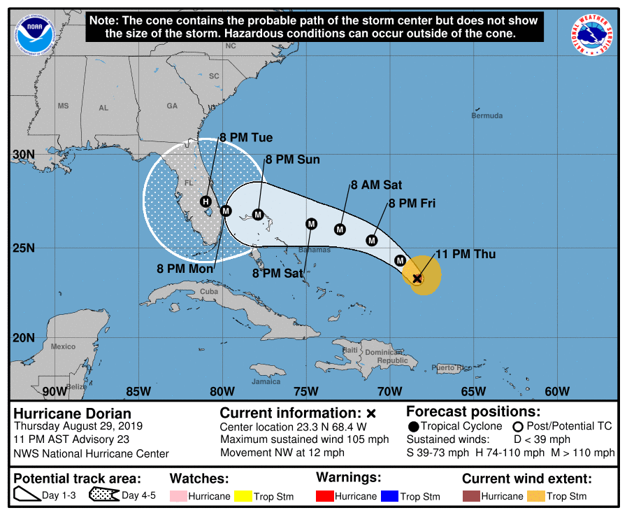
A very grim advisory from the National Hurricane Center. The storm is up to 105 mph, just why not a major hurricane.
The forecast is now calling for 140mph winds at landfall! It also has shifted south a little to the JupiterPalm Beach area.
It is important to not focus on the exact landfall point. Generally on a storm moving west, the worst wind and surge will be north of the center.
The forecast is now calling for 140mph winds at landfall! It also has shifted south a little to the JupiterPalm Beach area.
It is important to not focus on the exact landfall point. Generally on a storm moving west, the worst wind and surge will be north of the center.
a reply to: jrod
once again irma did not make landfall in fort myers it made landfall in marco island. they are not even in the same county. i wasnt comparing deaths in honduras and nicaragua to america, i was making a point that hurricane barely kill people in america. most of the deaths that do occur are caused by people being stupid. fyi the term 3rd world country applies to countries that didnt back america or ussr in the cold war scare. since the ussr dissolved in 1991 the term is meaningless. i wont bother replying to you anymore since you have proven that you will ignore facts and make up your own narrative on everything regardless of just being told the correct answer. perhaps you should be worried about hurricanes
once again irma did not make landfall in fort myers it made landfall in marco island. they are not even in the same county. i wasnt comparing deaths in honduras and nicaragua to america, i was making a point that hurricane barely kill people in america. most of the deaths that do occur are caused by people being stupid. fyi the term 3rd world country applies to countries that didnt back america or ussr in the cold war scare. since the ussr dissolved in 1991 the term is meaningless. i wont bother replying to you anymore since you have proven that you will ignore facts and make up your own narrative on everything regardless of just being told the correct answer. perhaps you should be worried about hurricanes
a reply to: fightzone58
There are many places in Central America and Haiti where people live in 3rd world conditions. This is a major contributor the very high death tolls they have with hurricanes.
The eye of Irma went through Fort Myers/Naples. That is a direct hit.
You are making a fool of yourself on here.
By definition a category 3 hurricane is a major hurricane. Something you tried to dispute...
I know my stuff when it comes to Hurricanes, I've been tracking them since I was 5.
This storm is not one to take lightly.
edit on 30-8-2019 by jrod because: ID10T
Dorian is up to 110mph as of 8am EDT today.
Watches will likely be issued for Florida with the 5pm advisory.
It is still expected to make landfall as an extremely strong category 4 hurricane in South to Central Florida.
Watches will likely be issued for Florida with the 5pm advisory.
It is still expected to make landfall as an extremely strong category 4 hurricane in South to Central Florida.
edit on 30-8-2019 by jrod
because: F
Forecasters and News Outlets are already trying to out-do each other, predicting how dire Dorian will be for Florida. "Absolute Monster" is one I
just heard.
a reply to: carewemust
This is one of the few storms that may live up or exceed the hype.
Possibly the strongest storm to strike the East Coast of Florida since Andrew in '92 is no joke. The mass hysteria of an approaching storm will cause some chaos this weekend.
This is one of the few storms that may live up or exceed the hype.
Possibly the strongest storm to strike the East Coast of Florida since Andrew in '92 is no joke. The mass hysteria of an approaching storm will cause some chaos this weekend.
a reply to: jrod
Dorian is very close to crossing hurricane Andrews track near 25.5 N, once it becomes a cat 5 hurricane it may stall.
A category 3 hurricane would be steered into Florida by the mid level ridge, but the computer models don't know where a cat 5 hurricane would go. Its like deep blue trying to predict a chess end game.
edit on 30-8-2019 by Slichter because: (no reason given)
I live in Florida on the east coast by Daytona Beach and I’m laughing. Why? Because they have no idea where it’s going yet!! It has literally
changed three times since I woke up this morning. They love to freak people out. Now it’s supposedly going to be a Cat 3 hitting south Florida and
coming up the middle as a 1. I’ve lived here for 35 years and they have never predicted a hurricane this far out. Honestly it gets quite annoying
because everything just stops until it hits and that could be Tuesday into Wednesday where I am. I’m not going anywhere. I’ll stay and sleep
through it like I did all the others. People are already going nuts in stores for water, food and wood. A friend of mine waited 7 hours in line for
sand bags! I guess because I’ve lived here so long I just don’t get all hyped up until I know exactly where it could go. I remember in 1999 they
told us we HAD to evacuate! We did and were stuck in traffic for 10 hours! It was hell and guess what the damn thing turned last minute and barely
touched us. So ever since then I don’t leave.
If you have to rely on the news to get you through this, I feel sorry for you. Find a wiser friend to stay in touch with.
When the news does stuff like this, can you trust them for accurate info.
Morning Weather Blog
As powerful as Dorian is right now, it's still fighting some issues keeping it from reaching its full potential. These may or may not get out of the way over the weekend. If they do, then look for Dorian to intensify rapidly before landfall. The scary thing, according to our meteorologist, is if Dorian can reach this level of power now, fighting dry air intrusions and similar weakening factors ... what will it do if those things get out of its way?
Still some questions as to exactly where it makes landfull and with how much power and what will happen to it after that. Right now, you're looking at that blocking high pressure system to the north. If it weakens or moves east (both somewhat unlikely to unlikely), then Dorian could still head north up the coast. But you're talking about the whole storm running right up the coast, not staying offshore, so Cat 3 to 4 levels of wind damage all along the coast.
There is also the possibility that the storm gets strong enough to pull up deeper and colder water and it could weaken itself that way ... or it gets strong enough that it ends up pulling itself further south than expected.
a reply to: roadgravel
This is from your link.
It looks like the models are wanting to start showing it running the coast. That's not good. If it hangs on/off the coast, it could maintain Cat 3 to 4 strength for a long time and do massive damage all the way up as it goes.
The ridge over the western Atlantic appears to be already building
to the north of Dorian and is beginning to force the hurricane on a
more west-northwest track or 300 degrees at 9 kt. The ridge is
forecast to build even more and steer Dorian on a westward track for
the next 3 to 4 days. However, the steering currents will then
weaken, and this should result in a decrease in the hurricane's
forward speed. Given the collapse of the steering currents, the
track forecast by the end of the forecast period is highly
uncertain, and any small deviation in the track could bring the
core of the powerful hurricane well inland over the Florida, keep
it near the coast, or offshore. The models have not been very
consistent from run to run in terms of the timing of the northward
turn, but there are more models now indicating that the turn could
occur near the east coast of Florida instead of well inland. Given
this latest change, the NHC forecast has been shifted just a little
to the right at this time, but users should be prepared for
additional adjustements to the left or right depending on future
model trends.
This is from your link.
It looks like the models are wanting to start showing it running the coast. That's not good. If it hangs on/off the coast, it could maintain Cat 3 to 4 strength for a long time and do massive damage all the way up as it goes.
The chances of a recurve have greatly increased but the storm has become a monster.
Still no hurricane watches or warnings for Florida.
Still no hurricane watches or warnings for Florida.
a reply to: jrod
haiti and central america are called undeveloped countries. 3rd world means you didnt align with nato or the communist bloc. the eye of irma went inland slightly and crossed lehigh acres. fort myers got the western wall. i hope you dont track storms for a living because you are not very good at it. dorian is finally worthy of being called a major hurricane now. if this storm keeps slowing down it could turn north before it hits florida. with the way you attempt to spread panic and disinformation, you should be working for nbc
haiti and central america are called undeveloped countries. 3rd world means you didnt align with nato or the communist bloc. the eye of irma went inland slightly and crossed lehigh acres. fort myers got the western wall. i hope you dont track storms for a living because you are not very good at it. dorian is finally worthy of being called a major hurricane now. if this storm keeps slowing down it could turn north before it hits florida. with the way you attempt to spread panic and disinformation, you should be working for nbc
new topics
-
Hurt my hip; should I go see a Doctor
General Chit Chat: 44 minutes ago -
Israel attacking Iran again.
Middle East Issues: 1 hours ago -
Michigan school district cancels lesson on gender identity and pronouns after backlash
Education and Media: 1 hours ago -
When an Angel gets his or her wings
Religion, Faith, And Theology: 2 hours ago -
Comparing the theology of Paul and Hebrews
Religion, Faith, And Theology: 3 hours ago -
Pentagon acknowledges secret UFO project, the Kona Blue program | Vargas Reports
Aliens and UFOs: 4 hours ago -
Boston Dynamics say Farewell to Atlas
Science & Technology: 4 hours ago -
I hate dreaming
Rant: 5 hours ago -
Man sets himself on fire outside Donald Trump trial
Mainstream News: 7 hours ago -
Biden says little kids flip him the bird all the time.
Politicians & People: 7 hours ago
top topics
-
The Democrats Take Control the House - Look what happened while you were sleeping
US Political Madness: 8 hours ago, 17 flags -
In an Historic First, In N Out Burger Permanently Closes a Location
Mainstream News: 10 hours ago, 16 flags -
A man of the people
Medical Issues & Conspiracies: 15 hours ago, 10 flags -
Biden says little kids flip him the bird all the time.
Politicians & People: 7 hours ago, 8 flags -
Man sets himself on fire outside Donald Trump trial
Mainstream News: 7 hours ago, 7 flags -
Pentagon acknowledges secret UFO project, the Kona Blue program | Vargas Reports
Aliens and UFOs: 4 hours ago, 6 flags -
Israel attacking Iran again.
Middle East Issues: 1 hours ago, 5 flags -
Michigan school district cancels lesson on gender identity and pronouns after backlash
Education and Media: 1 hours ago, 4 flags -
Boston Dynamics say Farewell to Atlas
Science & Technology: 4 hours ago, 4 flags -
4 plans of US elites to defeat Russia
New World Order: 17 hours ago, 4 flags
active topics
-
Hurt my hip; should I go see a Doctor
General Chit Chat • 6 • : charlest2 -
When an Angel gets his or her wings
Religion, Faith, And Theology • 2 • : stelth2 -
MULTIPLE SKYMASTER MESSAGES GOING OUT
World War Three • 51 • : Zaphod58 -
Israel attacking Iran again.
Middle East Issues • 19 • : stelth2 -
Pentagon acknowledges secret UFO project, the Kona Blue program | Vargas Reports
Aliens and UFOs • 7 • : Ophiuchus1 -
-@TH3WH17ERABB17- -Q- ---TIME TO SHOW THE WORLD--- -Part- --44--
Dissecting Disinformation • 549 • : cherokeetroy -
In an Historic First, In N Out Burger Permanently Closes a Location
Mainstream News • 9 • : VariedcodeSole -
A man of the people
Medical Issues & Conspiracies • 14 • : chr0naut -
British TV Presenter Refuses To Use Guest's Preferred Pronouns
Education and Media • 68 • : ToneD -
MH370 Again....
Disaster Conspiracies • 9 • : WakeUpBeer