It looks like you're using an Ad Blocker.
Please white-list or disable AboveTopSecret.com in your ad-blocking tool.
Thank you.
Some features of ATS will be disabled while you continue to use an ad-blocker.

Hurricane Dorian taking aim at Florida
page: 1share:
Florida will likely be hit by a major hurricane this weekend. Dorian strengthened into a hurricane this afternoon while striking the US Virgin Islands
and is expected to be near the East coast of Florida Sunday.
Preparations to secure property and life need to be happening now if you are anywhere from Miami to Jacksonville. There is still quite a bit of uncertainty where the exact landfall and the strength but a major hurricane making landfall on the east coast of Florida appears imminent.
www.nhc.noaa.gov...
edit on 28-8-2019 by jrod because: (no reason given)
Major edit fail
edit on 28-8-2019 by jrod because: (no reason given)
a reply to: Phage
Pretty much anywhere on the east coast of Florida could get the landfall. The computer models have been trending South all day, so right now I would guess West Palm to Cape Canaveral are most at risk. Mandatory evacuations will likely start Friday.
Once the storm makes the west turn coupled with the better computer model data(much more atmosphere sampling with an approaching storm) we should be able to narrow down where he will make landfall.
The next update is at 5pm from the NHC.
tropicaltidbits.com...
spaghettimodels.com...
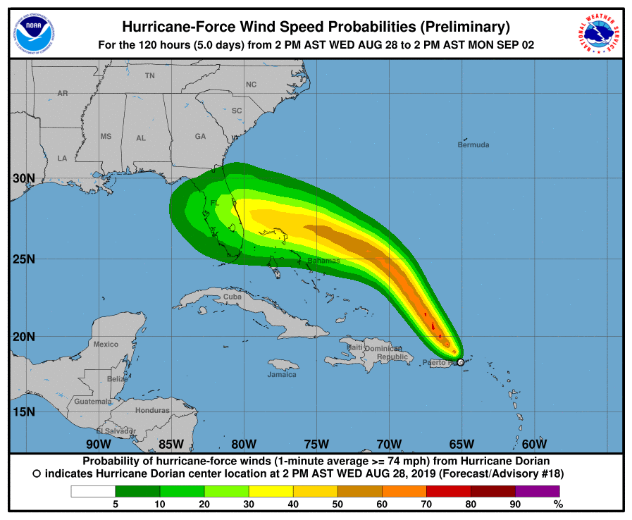
a reply to: Phage
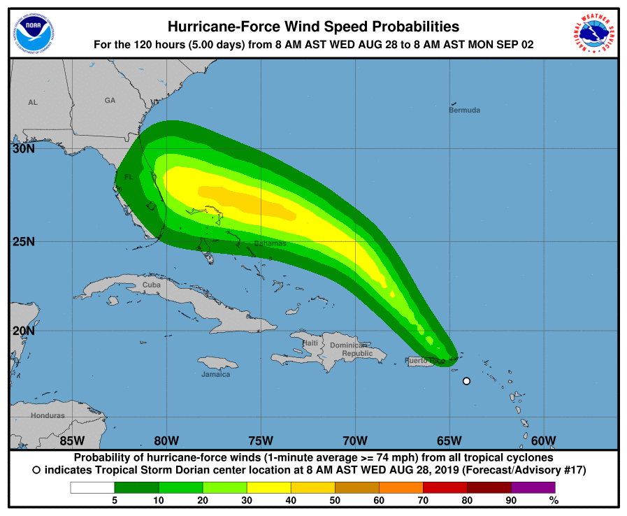
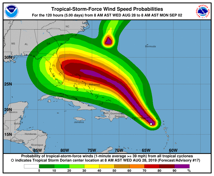
That probability map can be misleading. Something like 95% off the ensembles aka Spagetti models have it striking Florida.
There was talk of a weakness in the ridge that may allow the storm to turn more north, last night and this morning but today's computer model squashed that way of thinking. The Synoptic setup gives the storm no where else to go.
It should be noted the green lines that miss Florida are purely statistical models.
edit on 28-8-2019 by jrod because: Autocorrect does not
know weather terms
Our local meteorologist thinks that Dorian has a few tricks up his sleeve and could be harder to forecast than people think. None of that means folks
in Florida shouldn't be paying attention though, just that Dorian may do some weird stuff before making landfall.
How many hurricanes were predicted to strike the US mainland this season?
a reply to: jrod
The intensity forecasts are always a bit more of a crapshoot than the path forecasts. It's pretty certain that the storm will hit the East Coast. As of the last forecast, it seems much more likely to do so with tropical storm force winds than hurricane.
Going to be a crappy long weekend, either way.
edit on 8/28/2019 by Phage because: (no reason given)
The update will be out within minutes. As of 11am it was forecast to be a major hurricane just off Cape Canaveral on Sunday. I will wait until the 5pm
to post the next forecast cone.
Here is a weather forecast you don't see often, from Cocoa Beach:
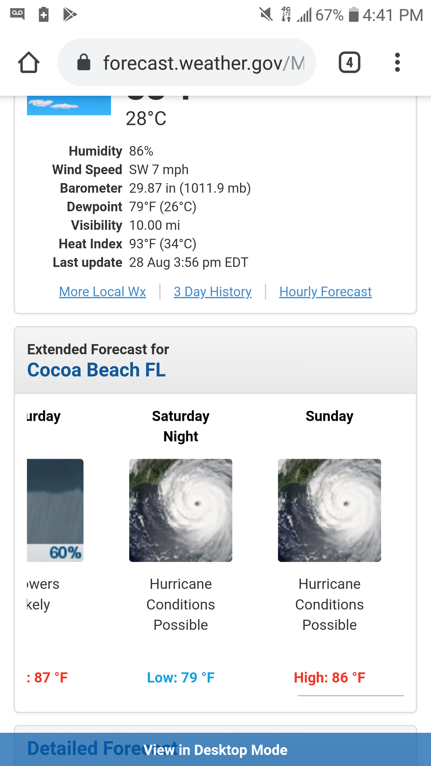
Here is a weather forecast you don't see often, from Cocoa Beach:
originally posted by: jrod
a reply to: ketsuko
If your local weatherman thinks he knows better than the National Hurricane Center, then he is an idiot and no one should take him seriously.
Out of curiosity who is he and what station airs him?
Someone who watches all the weather and knows that forecasts change from day to day, hour to hour, even minute to minute no matter what type of weather we're talking about. He's also usually fairly accurate with what he predicts, but he hasn't made any real predictions about Dorian yet aside from telling folks this is something to watch and be preparing for.
Did I say he thought it was going to miss Florida? Nope, not at all, only that he thinks Dorian's forecast will be more complex than a lot of people think at the moment.
And he has to keep an eye on tropical systems. They occasionally get up into our neck of the woods. Not often, but it has happened and brings inches of rain when it does.
edit on 28-8-2019 by ketsuko because: (no reason given)
Highlights from the 5 PM advisory:
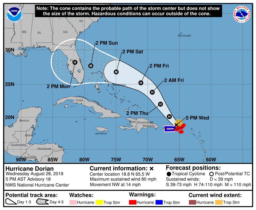
Forecasting a major hurricane strike.
1. Dangerous winds will continue in the Virgin Islands, Culebra,
Vieques, and portions of Puerto Rico during the next few hours.
Heavy rainfall over portions of Puerto Rico and the Virgin Islands
could produce flash flooding through Thursday morning.
2. The risk of dangerous storm surge and hurricane-force winds later
this week and this weekend continues to increase in the central and
northwestern Bahamas and along the Florida east coast, although it
is too soon to determine where these hazards will occur. Residents
in these areas should ensure they have their hurricane plan in place
and not focus on the exact forecast track of Dorian's center.
3. Heavy rains are expected to occur over portions of the Bahamas,
Florida, and elsewhere in the southeastern United States later this
week and into early next week.
FORECAST POSITIONS AND MAX WINDS
INIT 28/2100Z 18.8N 65.5W 70 KT 80 MPH
12H 29/0600Z 20.1N 66.6W 75 KT 85 MPH
24H 29/1800Z 22.0N 68.0W 80 KT 90 MPH
36H 30/0600Z 23.8N 69.3W 85 KT 100 MPH
48H 30/1800Z 25.2N 71.1W 90 KT 105 MPH
72H 31/1800Z 26.8N 75.0W 100 KT 115 MPH
96H 01/1800Z 27.7N 79.0W 100 KT 115 MPH
120H 02/1800Z 28.2N 81.5W 85 KT 100 MPH...INLAND
Forecasting a major hurricane strike.
a reply to: ketsuko
That is very wishy washy. So far this storm has been difficult to forecast. The initial thinking was it would hit Hispaniola and be shredded by the mountains. Only 1 of major computer model(UKMET) has had a good handle on the storm so far.
There is a very strong chance it will take WSW dive when the ridge that will push him west fills in. If so that will put the Straits of Florida back in the cone(and me).
Looks like my one weekend to make good money this month is ruined. Even if we get nothing in Key West, we will loose tourism.
Does your local guy have a name? It would to verify his credentials. Too many TV Mets have little in they way of credidentials, they get the job because of how they look and sound.
edit on 28-8-2019 by jrod because: (no reason given)
a reply to: Phage
forecast discussion
Latest forecast looks fairly certain - category 3 at landfall...
(hopefully this quote and link work - I'm just now learning how to 'cut and paste')
The cloud pattern has become better organized with a hint of an eye
on high resolution satellite imagery and plenty of convective bands.
In addition, earlier data from a reconnaissance plane and surface
observations from St. Thomas as Dorian moved by yield an initial
intensity of 70 kt. Now that the hurricane has developed an inner
core with a 15 to 20 n mi eye, strengthening is more likely. Given
the favorable environment of warm waters and low shear prevailing in
the western Atlantic, the NHC forecast calls for a marked
intensification, and brings Dorian to category 3 intensity in 72
hours, and keeps it at that intensity until landfall. This
forecast is very close to the intensity consensus, the HCCA model,
and the SHIPS guidance.
forecast discussion
Latest forecast looks fairly certain - category 3 at landfall...
(hopefully this quote and link work - I'm just now learning how to 'cut and paste')
edit on 28-8-2019 by lostgirl because: to put the quote in properly
edit on 28-8-2019 by lostgirl because: took 3 tries, but
I finally got it!
I'm in Ft. Lauderdale, I had to contact all of our vendors (I'm the chief engineer of a 500,000 sq foot campus) and get our generator tank topped off.
I'm not predicting anything crazy. This happens year after year, the news will build this up and get everyone in hysterics, all the gas and water gets
sold out and not much more but a tropical storm passes over. Supposedly Irma was going to be disastrous and all we had was drizzling rain and a lot of
wind. I was here for Wilma, so I certainly know what it's like to have our asses handed to us, but I take these with a grain of salt because 95% of
the time we're told it'll be bigger than it is.
Either way, stay safe down there in the Keys!
Either way, stay safe down there in the Keys!
new topics
-
University of Texas Instantly Shuts Down Anti Israel Protests
Education and Media: 1 hours ago -
Any one suspicious of fever promotions events, major investor Goldman Sachs card only.
The Gray Area: 3 hours ago -
God's Righteousness is Greater than Our Wrath
Religion, Faith, And Theology: 8 hours ago -
Electrical tricks for saving money
Education and Media: 11 hours ago
top topics
-
VP's Secret Service agent brawls with other agents at Andrews
Mainstream News: 12 hours ago, 10 flags -
Cats Used as Live Bait to Train Ferocious Pitbulls in Illegal NYC Dogfighting
Social Issues and Civil Unrest: 16 hours ago, 8 flags -
Nearly 70% Of Americans Want Talks To End War In Ukraine
Political Issues: 13 hours ago, 4 flags -
Sunak spinning the sickness figures
Other Current Events: 13 hours ago, 4 flags -
Electrical tricks for saving money
Education and Media: 11 hours ago, 4 flags -
Late Night with the Devil - a really good unusual modern horror film.
Movies: 15 hours ago, 2 flags -
Any one suspicious of fever promotions events, major investor Goldman Sachs card only.
The Gray Area: 3 hours ago, 2 flags -
University of Texas Instantly Shuts Down Anti Israel Protests
Education and Media: 1 hours ago, 1 flags -
God's Righteousness is Greater than Our Wrath
Religion, Faith, And Theology: 8 hours ago, 0 flags
active topics
-
Nearly 70% Of Americans Want Talks To End War In Ukraine
Political Issues • 36 • : Xtrozero -
University of Texas Instantly Shuts Down Anti Israel Protests
Education and Media • 3 • : CriticalStinker -
Sunak spinning the sickness figures
Other Current Events • 13 • : Xtrozero -
Any one suspicious of fever promotions events, major investor Goldman Sachs card only.
The Gray Area • 7 • : seekshelter -
Hate makes for strange bedfellows
US Political Madness • 42 • : network dude -
-@TH3WH17ERABB17- -Q- ---TIME TO SHOW THE WORLD--- -Part- --44--
Dissecting Disinformation • 663 • : MetalThunder -
Russia Ukraine Update Thread - part 3
World War Three • 5731 • : Freeborn -
President BIDEN Vows to Make Americans Pay More Federal Taxes in 2025 - Political Suicide.
2024 Elections • 137 • : CriticalStinker -
I think this life means something.
Philosophy and Metaphysics • 59 • : seekshelter -
Late Night with the Devil - a really good unusual modern horror film.
Movies • 5 • : chiefsmom