It looks like you're using an Ad Blocker.
Please white-list or disable AboveTopSecret.com in your ad-blocking tool.
Thank you.
Some features of ATS will be disabled while you continue to use an ad-blocker.

California earthquake crack can be seen in satellite image
page: 129
share:
Satellite images provided to CNN by Planet Labs, Inc. show a crack has formed in the area close to the epicenter.
The large crack extends some distance from an area that apparently held water before. The erosion patterns on the desert sand indicate that some of that water was sucked out.
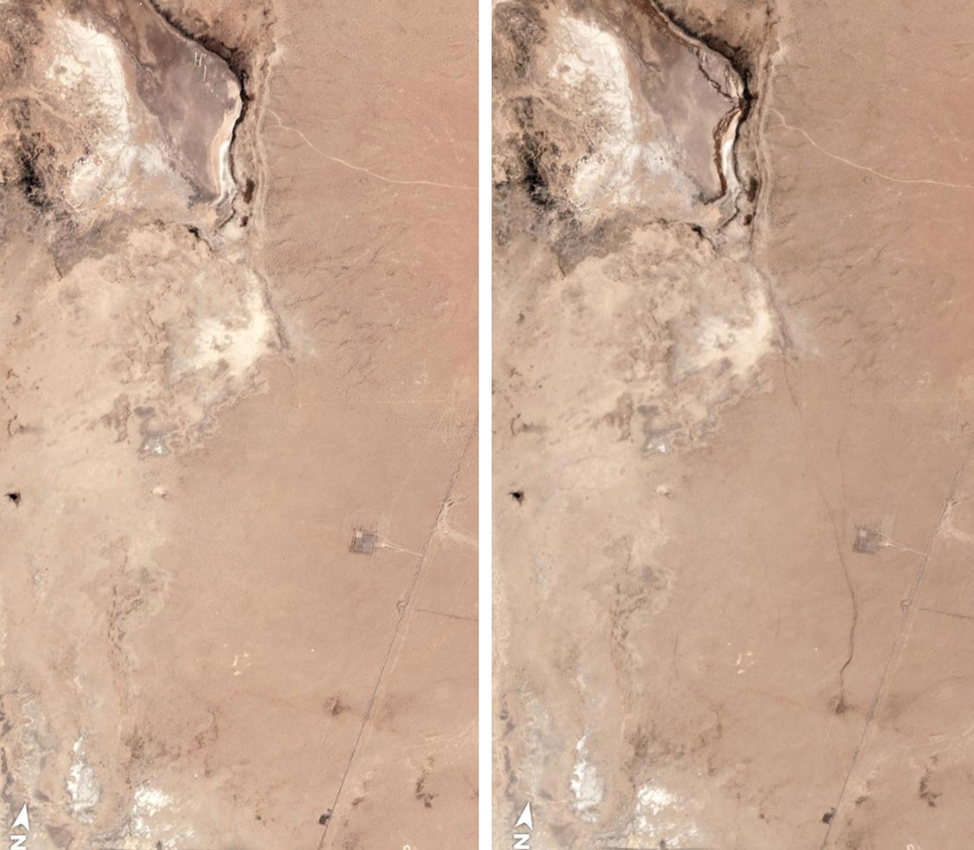
California earthquake created a massive crack in the Earth visible in satellite images
The image on the left is the before image and on the right is the after image. The crack is said to have been caused by the 7.1 magnitude earthquake.
Below is a ground truth image from the USGS twitter account.
This photo was taken on 178 SW of Trona. The road is now closed for repairs.
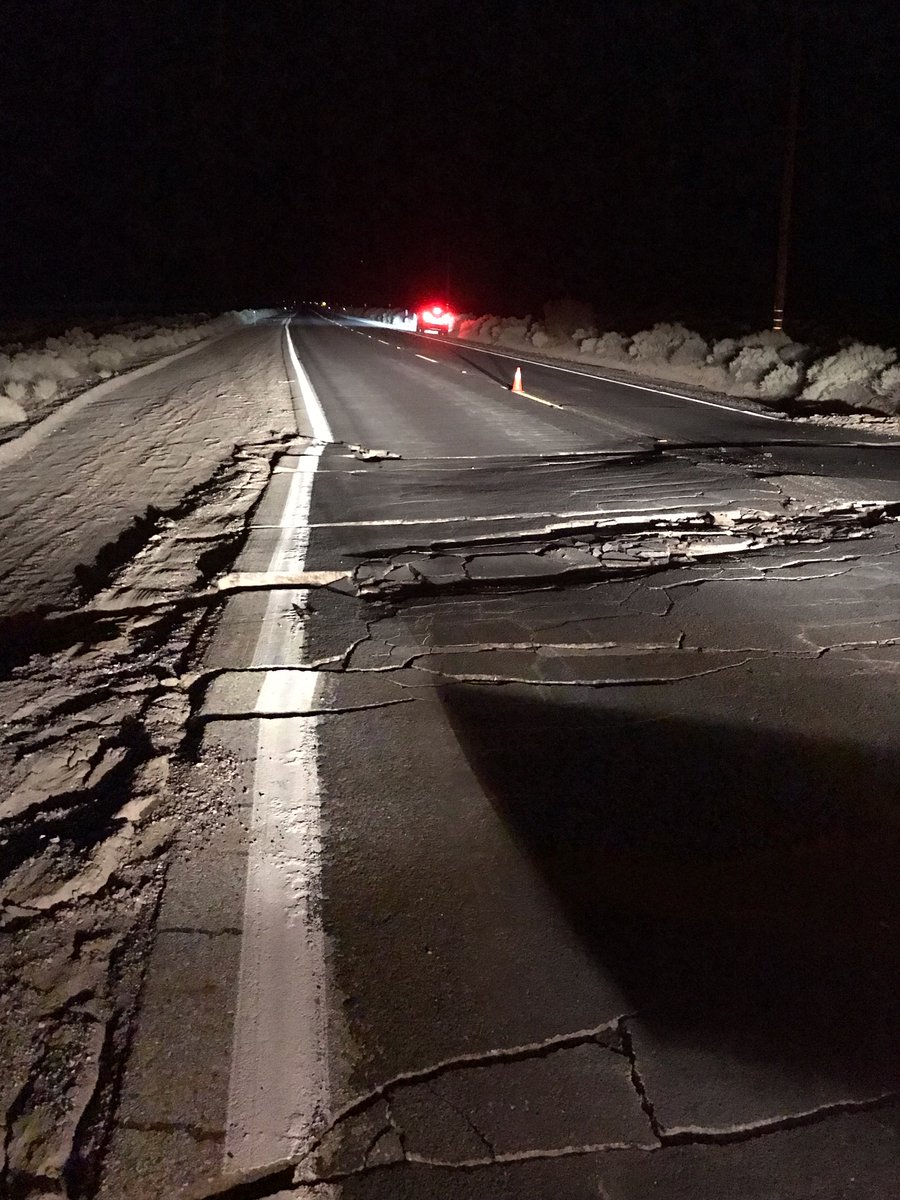
USGS Twitter
Looks like nuke or strangelette bomb detonated in the fault
sort of like Lex Luther did in Superman movie, but then again he's not military, is he?
sort of like Lex Luther did in Superman movie, but then again he's not military, is he?
a reply to: LookingAtMars
They did an overflight of the bombing range, and measured a 6.5 foot lateral shift. On the road, it was something like 3 feet vertically.
They did an overflight of the bombing range, and measured a 6.5 foot lateral shift. On the road, it was something like 3 feet vertically.
originally posted by: Zaphod58
a reply to: LookingAtMars
They did an overflight of the bombing range, and measured a 6.5 foot lateral shift. On the road, it was something like 3 feet vertically.
Still better than most roads in Michigan.
Maybe the bird is pecking at the shell from underneath trying to be born. Maybe the earth is a dragon egg.
Of course, nothing so cool would ever happen.
Of course, nothing so cool would ever happen.
You guys are funny! A little silly too
It better not have been an underground bomb. There will be plenty of lawsuits if it was. Someone will have some splaining to do, and it will be all Trumps fault. Get it? Trumps fault
It better not have been an underground bomb. There will be plenty of lawsuits if it was. Someone will have some splaining to do, and it will be all Trumps fault. Get it? Trumps fault
a reply to: Zaphod58
First thing they here in Anchorage was get a helicopter up (remember, we had a 7.2 Turkey Day, 2018).
We had ground liquefaction in frozen ground around water sources. Not a big @ss crack... but a straight line (kinda. Followed the highway which was also cracked)
I would think that the same forces were at play but in different ground types: liquid and ground with a whole bunch of shaking!
Still, that is ton of crack!
a reply to: LookingAtMars
The power of nature is absolutely terrifying, I can't imagine experiencing something with enough power to do this. I would love to explore the crack for rocks and gemstones, I know that would ne incredibly unsafe though (not to mention too expensive to achieve)...
The power of nature is absolutely terrifying, I can't imagine experiencing something with enough power to do this. I would love to explore the crack for rocks and gemstones, I know that would ne incredibly unsafe though (not to mention too expensive to achieve)...
Here is more satellite data.
"Linear color lines indicate where an area was cracked open or was disturbed."
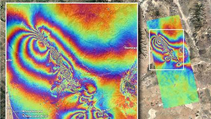
Ridgecrest earthquakes caused damage to the earth’s crust seen from satellite
"Linear color lines indicate where an area was cracked open or was disturbed."
The Advanced Rapid Imaging and Analysis team at NASA’s Jet Propulsion Laboratory in Pasadena, California, used satellite data to produce a map showing ruptures and displacements not visible to the naked eye — employing technology that has been developed over the last quarter century. The imagery was acquired on July 8 and compared with data from April 8.
Ridgecrest earthquakes caused damage to the earth’s crust seen from satellite
a reply to: LookingAtMars
Looks like the local Coso Petroglyphs. Maybe those glyphs are maps of an underground area. Not crazy humans aliens.
PIC in link below:
I’m this glyph, You have a long body, like the main chamber and a circular head which could be another part of the underground system. Arms are shafts. The side by side of a similar smaller figure could indicate a lower level like a two storied cave. link to Photo of Coso Petroglyph
Sorry for the link for some reason I Can’t upload photos from my phone now.
a reply to: Observationalist
I can see where that could be what some of the pics show. You should start a thread about that.
It is strange that there is so much art in a desert. Stranger still is some of the things in the pics.
I can see where that could be what some of the pics show. You should start a thread about that.
It is strange that there is so much art in a desert. Stranger still is some of the things in the pics.
Armitage Airfield at China Lake reopened late in the week, with aircraft from VX-9 (F-18E/F and EA-18G) flying from the base, to verify necessary
equipment was functional, and test that the runway and ramp areas were safe to operate from.
originally posted by: LookingAtMars
a reply to: Observationalist
I can see where that could be what some of the pics show. You should start a thread about that.
It is strange that there is so much art in a desert. Stranger still is some of the things in the pics.
Thanks.
Sadly at I can only post from my phone at this point. So starting a thread like that, with lots of pics will be tough.
I’m more and more thinking these glyphs are not meant to be a representation of human or aliens, but some devise or dwelling. The glyphs is like a schematic drawing. On a small scale a battery comes to mind, or like I said, an underground chamber with vent shafts and the such.
Perhaps they chose the location of this base because of what they discovered in these canyons.
a reply to: Observationalist
The original artists and the Navy my have chose this land for the same reason.
Perhaps they chose the location of this base because of what they discovered in these canyons.
The original artists and the Navy my have chose this land for the same reason.
a reply to: Observationalist
It actually started life as the Naval Ordnance Test Station in 1943. CalTech was looking for a range to test rockets, including the 3.5", 5", and 11.75" rockets, and the Navy was looking for a location to test aviation ordnance. The lake bed had previously been used to collect borax. The airfield was built using Manhattan Project funds, and as part of Project Camel, B-29s tested atomic bomb shapes.
It actually started life as the Naval Ordnance Test Station in 1943. CalTech was looking for a range to test rockets, including the 3.5", 5", and 11.75" rockets, and the Navy was looking for a location to test aviation ordnance. The lake bed had previously been used to collect borax. The airfield was built using Manhattan Project funds, and as part of Project Camel, B-29s tested atomic bomb shapes.
new topics
-
HORRIBLE !! Russian Soldier Drinking Own Urine To Survive In Battle
World War Three: 1 hours ago -
Bobiverse
Fantasy & Science Fiction: 4 hours ago -
Florida man's trip overseas ends in shock over $143,000 T-Mobile phone bill
Social Issues and Civil Unrest: 4 hours ago -
Former Labour minister Frank Field dies aged 81
People: 6 hours ago -
SETI chief says US has no evidence for alien technology. 'And we never have'
Aliens and UFOs: 8 hours ago -
This is our Story
General Entertainment: 11 hours ago
top topics
-
President BIDEN Vows to Make Americans Pay More Federal Taxes in 2025 - Political Suicide.
2024 Elections: 13 hours ago, 16 flags -
One Flame Throwing Robot Dog for Christmas Please!
Weaponry: 17 hours ago, 6 flags -
Florida man's trip overseas ends in shock over $143,000 T-Mobile phone bill
Social Issues and Civil Unrest: 4 hours ago, 6 flags -
SETI chief says US has no evidence for alien technology. 'And we never have'
Aliens and UFOs: 8 hours ago, 6 flags -
Former Labour minister Frank Field dies aged 81
People: 6 hours ago, 4 flags -
Ditching physical money
History: 17 hours ago, 4 flags -
This is our Story
General Entertainment: 11 hours ago, 3 flags -
Ode to Artemis
General Chit Chat: 14 hours ago, 3 flags -
Bobiverse
Fantasy & Science Fiction: 4 hours ago, 3 flags -
HORRIBLE !! Russian Soldier Drinking Own Urine To Survive In Battle
World War Three: 1 hours ago, 1 flags
active topics
-
President BIDEN Vows to Make Americans Pay More Federal Taxes in 2025 - Political Suicide.
2024 Elections • 68 • : Boomer1947 -
-@TH3WH17ERABB17- -Q- ---TIME TO SHOW THE WORLD--- -Part- --44--
Dissecting Disinformation • 646 • : Thoughtful3 -
HORRIBLE !! Russian Soldier Drinking Own Urine To Survive In Battle
World War Three • 9 • : budzprime69 -
Thousands Of Young Ukrainian Men Trying To Flee The Country To Avoid Conscription And The War
Other Current Events • 131 • : Consvoli -
American Government to Sanction Israel Defence Force in the West Bank
Middle East Issues • 54 • : yuppa -
Florida man's trip overseas ends in shock over $143,000 T-Mobile phone bill
Social Issues and Civil Unrest • 5 • : Consvoli -
Breaking Baltimore, ship brings down bridge, mass casualties
Other Current Events • 478 • : IndieA -
Russia Ukraine Update Thread - part 3
World War Three • 5726 • : stu119 -
One Flame Throwing Robot Dog for Christmas Please!
Weaponry • 10 • : ATruGod -
New whistleblower Jason Sands speaks on Twitter Spaces last night.
Aliens and UFOs • 51 • : Ophiuchus1
29